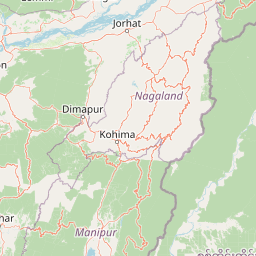
Why Ntangki National Park stands out
Ntangki National Park is best known for its pristine semi-evergreen and moist evergreen forests that harbor significant populations of large mammals including elephants, tigers, and leopards. The park represents one of the last remaining contiguous forest blocks in Nagaland and serves as a crucial habitat for species adapted to the montane forest ecosystems of the northeastern Himalayas. The area is also recognized for its bird diversity and the presence of several endemic species found nowhere else in India.
Ntangki National Park history and protected-area timeline
Ntangki National Park was originally declared a wildlife sanctuary in 1986 under the Indian Wildlife Protection Act, recognizing the need to conserve the remaining forest ecosystems in Nagaland's mountainous terrain. The area was subsequently upgraded to national park status in 1993, providing it with stronger legal protection and stricter regulations against activities such as hunting, logging, and habitat destruction. This transition reflected growing recognition of the park's significance as a repository of biodiversity in one of India's most ecologically rich but threatened regions. The establishment of the park came during a period when conservation priorities in northeastern India were gaining increased attention, as the region's unique ecosystems faced mounting pressures from development, agriculture, and resource extraction. Management of the park has involved efforts to balance ecological preservation with the needs of local communities who have historically depended on the forest landscape.
Ntangki National Park landscape and geographic character
The landscape of Ntangki National Park is defined by its location in the Naga Hills, a mountainous region forming part of the extensive arc of mountains that separates the Indian subcontinent from Southeast Asia. The terrain is predominantly hilly and steep, with narrow valleys carved by perennial streams that drain into larger river systems. The forest cover is dense and continuous, comprising semi-evergreen and moist evergreen formations that remain verdant throughout much of the year. The elevation gradient creates visual diversity, with lower slopes supporting more tropical vegetation while higher elevations feature species adapted to cooler, more montane conditions. Ridgelines within the park offer sweeping views of the surrounding forested mountains, though the terrain is rugged enough to make extensive foot travel challenging. The park's watersheds provide important hydrological functions, regulating water flow and preventing soil erosion in this mountainous landscape.
Ntangki National Park ecosystems, habitats, and plant life
The natural environment of Ntangki National Park exemplifies the Indo-Burma biodiversity hotspot, one of the world's most important regions for conservation due to its extraordinary species richness and high degree of endemism. The park's vegetation comprises tropical semi-evergreen forests and moist evergreen forests, characterized by tall trees, dense canopy, and多层 understory vegetation. These forest types support complex ecological communities adapted to the region's high rainfall and moderate temperatures. The park's location at the crossroads of Himalayan and Southeast Asian biogeographic influences means that species from both realms are present, creating a unique ecological blend. The forest structure provides habitat for numerous species of mammals, birds, reptiles, and invertebrates, many of which are threatened by habitat loss elsewhere in their ranges.
Ntangki National Park wildlife and species highlights
Ntangki National Park supports populations of several large mammal species that are characteristic of northeastern India's forests. The park is known to harbor elephants, tigers, and leopards, representing the apex predators and megaherbivores that require large, contiguous forest areas. Smaller carnivores including various species of cats, civets, and mustelids are also present. Ungulate species such as sambar deer, gaur, and hog deer occupy the forest understory and open areas, while primates including langurs may be found in the canopy. The bird fauna is particularly diverse, with numerous resident species supplemented by seasonal migrants. The park's streams and water bodies support aquatic biodiversity, though specific species inventories for the park remain limited. The presence of these wildlife populations makes Ntangki important for maintaining ecological processes in the Naga Hills region.
Ntangki National Park conservation status and protection priorities
Ntangki National Park plays a critical role in conserving the remaining old-growth forest ecosystems of Nagaland, a region that has experienced significant habitat loss and fragmentation due to agricultural expansion, logging, and development pressures. The park protects species that are increasingly rare in northeastern India, including populations of elephants and tigers that require large, contiguous habitats to maintain viable populations. As part of the Indo-Burma biodiversity hotspot, the park contributes to regional conservation goals by preserving a sample of the unique ecosystems that exist in this globally significant area. Management challenges include addressing human-wildlife conflict, preventing poaching and illegal extraction, and maintaining forest connectivity with adjacent landscapes. The park also serves as an important reference area for understanding the ecology of montane forests in the eastern Himalayas.
Ntangki National Park cultural meaning and human context
Ntangki National Park exists within a landscape that has been inhabited by Naga communities for generations, and the forest holds cultural and practical significance for these local populations. Traditional practices including shifting cultivation, hunting, and collection of forest products have shaped the relationship between communities and the land over centuries. The establishment of the park as a protected area has created both opportunities and challenges for these communities, requiring navigation between conservation objectives and local livelihoods. Several Naga villages are located in the vicinity of the park, and community involvement has been recognized as important for successful long-term conservation. The cultural context of the park reflects the broader story of conservation in northeastern India, where protected areas often overlap with lands of indigenous and local communities.
Top sights and standout views in Ntangki National Park
Ntangki National Park offers visitors the opportunity to experience some of northeastern India's least-explored forest landscapes, where Dense semi-evergreen vegetation covers steep hillsides and wildlife moves through relatively untouched habitat. The park's significance as an elephant and tiger habitat makes it particularly notable among India's protected areas, while its location in Nagaland provides a cultural dimension that distinguishes it from parks in more mainstream destinations. The montane forest ecosystems support a richness of biodiversity that remains incompletely documented, offering potential for discovery and scientific study. The park remains less visited than many other Indian national parks, preserving a sense of remoteness and wilderness that appeals to those seeking authentic natural experiences.
Best time to visit Ntangki National Park
The most favorable period for visiting Ntangki National Park typically falls during the cooler, dry months from October through March, when weather conditions are more comfortable for outdoor exploration and wildlife viewing opportunities may improve as animals congregate around remaining water sources. The monsoon season from June to September brings heavy rainfall to the Naga Hills, making some areas difficult to access and increasing the risk of landslides on mountain roads. Winter months can bring cold temperatures, especially at higher elevations within the park. Visitors planning trips should be aware that access and facilities may be limited compared to more developed parks, and arrangements should be made in advance through local authorities.