

Mori Atlas logo
National parkIsla Isabel National Park

Discover the mapped boundaries and distinct landscape of this national park in Nayarit.

Isla Isabel National Park: Navigating Nayarit's Protected Island Geography

(Parque Nacional Isla Isabel)

Isla Isabel National Park stands as a distinct protected area within the regional geography of Nayarit, Mexico. This national park offers a unique opportunity for atlas-based exploration, focusing on its island terrain and mapped natural landscape. Understanding Isla Isabel National Park involves appreciating its specific geographic context and its role as a conservation landscape within the broader atlas of protected areas.

volcanic islandseabird coloniesRamsar sitePacific coastbird sanctuarymarine protected area

Isla Isabel National Park

National park

Park overview

Structured park overview, official facts, and landscape profile for Isla Isabel National Park

Isla Isabel National Park park facts, protected area profile, and essential visitor context

Review the core facts for Isla Isabel National Park, including designation, size, terrain, visitor scale, habitats, and operating context in one park-focused overview.

About Isla Isabel National Park

Isla Isabel National Park protects a volcanic island of significant ecological importance in the Mexican Pacific. Despite its small land area, the park encompasses a complete island ecosystem including terrestrial habitats, coastal cliffs, and surrounding marine waters that together support remarkable biodiversity. The island's volcanic geology has produced a landscape characterized by steep cliffs, rocky promontories, and irregular terrain that creates numerous sheltered nesting sites for seabirds. These conditions have made Isla Isabel one of the most important nesting colonies for frigatebirds and boobies along the Pacific coast of North America. The surrounding ocean waters support marine ecosystems that contribute to the site's Ramsar Wetland designation, recognizing the importance of the combined terrestrial and marine environment. The park represents Mexico's commitment to protecting critical seabird habitat and maintaining biodiversity in the eastern Pacific region.

Quick facts and research context for Isla Isabel National Park

Isla Isabel National Park covers 1.94 square kilometers of volcanic island terrain in Nayarit, Mexico, in the Pacific Ocean. The park was established in 1980 and received Ramsar Wetland designation in 2003, recognizing its international importance as a seabird nesting site. The island is managed by Mexico's National Commission of Natural Protected Areas. Its volcanic geological formation creates a distinctive landscape of cliffs, rocky outcrops, and coastal formations that support dense seabird colonies.

Protection and recognition

Verifying the 2003 designation history and international conservation recognition

Isla Isabel National Park Protection Status and Ramsar Site Designation

Geographic records outline the official protected area designation of Isla Isabel National Park, which was established in 2003. International records confirm its registered inclusion as a Ramsar Wetland of International Importance, aligning local conservation efforts with global ecological frameworks.

International recognition

Protection details

Designated year
2003
Transboundary protection
No
Park context

Deeper park guide and search-rich context for Isla Isabel National Park

Isla Isabel National Park history, landscape, wildlife, and travel context

Explore Isla Isabel National Park through its history, landscape character, ecosystems, wildlife, conservation priorities, cultural context, and seasonal travel timing in a structured park guide built for atlas discovery and search intent.

Why Isla Isabel National Park stands out

Isla Isabel is best known as a premier seabird nesting colony in the eastern Pacific. The island supports one of the largest populations of frigatebirds in the region, along with significant colonies of booby species and other marine birds. The dramatic volcanic landscape, with its towering cliffs and rugged shoreline, provides ideal nesting habitat. The surrounding marine waters are equally important, supporting diverse marine life and contributing to the park's recognition as a Ramsar Wetland site.

Isla Isabel National Park history and protected-area timeline

Isla Isabel National Park was established in 1980 as part of Mexico's expanding network of protected natural areas. The park was created to protect the island's significant seabird colonies and the unique volcanic island ecosystem. In 2003, the site received additional recognition as a Ramsar Wetland, designating it as a wetland of international importance under the Ramsar Convention. This dual protection status reflects both the terrestrial bird nesting habitat and the surrounding marine waters that together form an ecologically significant unit. Management of the park falls under Mexico's National Commission of Natural Protected Areas, which oversees conservation and monitoring activities.

Isla Isabel National Park landscape and geographic character

Isla Isabel is a volcanic island rising from the Pacific Ocean off the coast of Nayarit. The island's terrain is dominated by volcanic rock formations, steep cliffs that drop directly into the sea, and rocky coastal shores. The interior of the island features irregular volcanic terrain with exposed rock and limited vegetation in certain areas. The dramatic coastline includes vertical cliff faces that provide ideal nesting habitat for seabirds, as well as rocky outcrops and small beaches where marine life congregates. The surrounding Pacific waters complete the park's landscape, creating a seamless marine-terrestrial conservation area.

Isla Isabel National Park ecosystems, habitats, and plant life

The ecological significance of Isla Isabel centers on its role as a critical seabird nesting colony in the eastern Pacific. The island supports dense populations of frigatebirds, which nest in the cliff areas and surrounding vegetation where it exists. Booby colonies, including both blue-footed and other species, also nest on the island, creating one of the most significant seabird aggregation sites in the region. The surrounding marine waters support fish populations and other marine life that sustain the seabird colonies. The combination of volcanic island terrain, coastal marine environments, and the absence of significant human disturbance has allowed these bird populations to thrive. The Ramsar designation recognizes both the terrestrial nesting habitat and the marine foraging areas as essential components of this important bird ecosystem.

Isla Isabel National Park wildlife and species highlights

Isla Isabel's wildlife is defined by its remarkable seabird populations. Frigatebirds represent one of the most prominent species groups, with the island serving as a major nesting and resting site for these distinctive birds. Booby colonies, including several species adapted to the Pacific coast, nest alongside the frigatebirds in the cliff habitats. The surrounding waters support fish species that the seabirds feed on, creating an interconnected marine-terrestrial food web. The island's isolated position in the Pacific makes it a crucial waypoint for migratory seabirds traveling along the Pacific flyway. While the focus is on birdlife, the marine environment around the island supports additional species that contribute to the overall biodiversity of the protected area.

Isla Isabel National Park conservation status and protection priorities

Isla Isabel National Park holds significant conservation value as one of the premier seabird nesting sites in the eastern Pacific. The Ramsar Wetland designation in 2003 elevated the site's international recognition and reinforced protection measures for both terrestrial and marine components. The park protects critical nesting habitat for frigatebirds and boobies, species that face pressures from habitat loss and disturbance throughout their ranges. Management by Mexico's National Commission of Natural Protected Areas ensures monitoring and enforcement that maintains the island as a relatively undisturbed environment. The small size of the island and its offshore location provide natural protection from many anthropogenic pressures that affect mainland protected areas, though ongoing vigilance regarding marine pollution and potential disturbance remains important for maintaining the health of the seabird colonies.

Isla Isabel National Park cultural meaning and human context

Isla Isabel has historically served as a maritime landmark for sailors and fishermen navigating the Pacific coast of Nayarit. The island's prominent position in the ocean and its distinctive volcanic silhouette have made it a recognizable feature of the regional seascape. While the island itself does not support permanent human settlement due to its protected status, the surrounding waters have traditionally been used by local fishing communities. The park status protects the island while allowing for carefully managed access for research and conservation purposes.

Top sights and standout views in Isla Isabel National Park

The volcanic island landscape of Isla Isabel, with its dramatic cliffs and Pacific Ocean setting, creates a distinctive protected area. The dense seabird colonies, particularly frigatebirds and boobies, represent the park's most significant ecological feature. The Ramsar Wetland designation recognizes the dual terrestrial-marine importance of this small but vital conservation area. The island's isolation provides natural protection for nesting bird populations, making it a success story in seabird conservation.

Best time to visit Isla Isabel National Park

Isla Isabel can be visited throughout the year, though conditions vary with seasonal weather patterns in the Pacific. The dry season from December through May typically offers more stable conditions for boat access to the island. Wildlife viewing, particularly of seabird colonies, is best during nesting seasons when bird activity is most visible. Marine conditions influence access, as the park is reached by boat from the mainland coast of Nayarit.

Monthly climate preview

Long-term representative temperature and precipitation patterns across twelve months

Isla Isabel National Park Climate Normals and Monthly Weather Records

Representative coordinate records show measured annual temperature and precipitation shifts for Isla Isabel National Park from 1991 to 2020. Reviewing the complete monthly profile provides detailed long-term averages for scientific evaluation and structured geographic comparison.
Annual mean26 °C
23 °C29 °C
Jan23°
Feb23°
Mar24°
Apr25°
May27°
Jun28°
Jul28°
Aug29°
Sep28°
Oct28°
Nov26°
Dec24°
Warmest month
August

28.6 °C

Coolest month
January

23.2 °C

Wettest month
August

11.3 mm/day

Driest month
April

0 mm/day

Park location guide

Geography guide, regional context, and park location map for Isla Isabel National Park

Isla Isabel National Park park geography, regions, and map view in Mexico

Understand where Isla Isabel National Park sits in Mexico through a broader geographic reading of the surrounding landscape, nearby location context, and its mapped position within the national park landscape.

How Isla Isabel National Park fits into Mexico

Mexico, officially the United Mexican States, is a country in North America spanning the Sierra Madre mountain ranges, coastal plains, and tropical regions. It borders the United States to the north, Guatemala and Belize to the southeast, and has coastlines along the Pacific Ocean, Gulf of Mexico, and Caribbean Sea. With a population exceeding 130 million, Mexico is home to one of the world's most significant concentrations of Indigenous languages alongside Spanish.

Wider geography shaping Isla Isabel National Park in Mexico

Mexico occupies a land area of 1,972,550 km2, making it the thirteenth-largest country in the world. The terrain is highly diverse, featuring the Sierra Madre Occidental and Sierra Madre Oriental mountain ranges, the Mexican Plateau, coastal lowlands along the Pacific and Gulf/Caribbean margins, and the Yucatan Peninsula. The country spans multiple climate zones from desert in the north to tropical rainforest in the south.

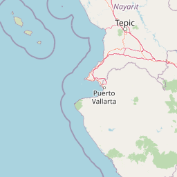
Map view of Isla Isabel National Park

Use this park location map to pinpoint Isla Isabel National Park in Mexico, understand its exact geographic position, and read its mapped placement within the surrounding landscape more clearly.

Pigeon | © OpenStreetMap contributors

Location context for Isla Isabel National Park

Nayarit
Recorded earthquake history

Review Historical Seismic Activity Data for Isla Isabel National Park

Examine the historical catalogue of recorded seismic events associated with Isla Isabel National Park. MoriAtlas provides a clear, data-driven view of documented earthquake activity, including event magnitude and distance, to support deeper geographic understanding of this Pacific island protected area.

Isla Isabel National Park Earthquake History

Catalogued events

2 events

Strongest magnitude

Magnitude 5.6

Most recent event

Feb 16, 2023

This history includes earthquakes recorded inside the park or within 50 km of its borders

Park atlas

Trace Nearby Protected Landscapes and Marine Conservation Zones Along Mexico's Pacific Coast

Discover Related National Parks and Protected Areas Beyond Isla Isabel National Park

Browse a curated atlas of national parks and protected areas geographically relevant to Isla Isabel National Park, including coastal zones and marine reserves along Mexico's Pacific coast. Explore this regional context to compare diverse conservation efforts and understand the spread of protected landscapes beyond the immediate vicinity of this unique volcanic island.
Biosphere reserveNayarit
About 71 km away#1 closest

Southwest

Islas Marías Biosphere Reserve: Geographic Overview and Protected Island Mapping

Volcanic topography and marine ecosystems in the Pacific.

The Islas Marías archipelago represents a significant protected area within the Mexican Pacific. Defined by its four major islands and diverse volcanic terrain, the reserve supports unique endemic species and expansive marine ecosystems. This overview tracks the geographic boundaries, island profiles, and the ecological importance of this remote Pacific territory offshore from the state of Nayarit.

Area
244.97 km²
Established
2010
Relief
Upland
Climate
Subtropical
Biosphere reserveNayarit
About 103 km away#2 closest

Southeast

Sierra de San Juan Biosphere Reserve: Geographic Overview and Protected Area Mapping

Volcanic terrain and forest ecosystems in Nayarit, Mexico

Explore the volcanic landforms and layered forest communities of Sierra de San Juan Biosphere Reserve. This protected area in Nayarit spans distinct ecological zones from dry coastal lowlands to mountain cloud forests, providing essential habitat and unique biodiversity at the convergence of major Mexican mountain systems.

Area
198.01 km²
Established
2003
Relief
Mountain
Scope
Terrestrial
National parkNayarit
About 130 km away#3 closest

South

Islas Marietas National Park: National Park Protected Landscape and Geographic Context

Explore its mapped boundaries and natural terrain in Nayarit.

Discover the distinct protected landscape of Islas Marietas National Park, a vital national park situated in the Nayarit region of Mexico. This entry facilitates a detailed exploration of its mapped geography and protected area status, offering a specific focus on the park's natural terrain and its significance within the broader atlas of conservation lands. Understand the unique context provided by its location and designation for comprehensive geographic discovery.

IUCN
II
Visitors
127.4K annual
Climate
Tropical
Access
Moderate access
Protected areaMexico
About 146 km away#4 closest

East

Cuenca Alimentadora del Distrito Nacional de Riego 043 Estado de Nayarit: Atlas Overview

Watershed reserve and montane forest geography

This extensive protected area spans the Sierra Madre Occidental, featuring a fragmented landscape of high mountain ridges separated by river valleys. It safeguards critical pine and oak forest ecosystems that supply the Irrigation District 043, serving as a vital natural resource hub in west-central Mexico.

Area
23,290.3 km²
Established
1949
IUCN
VI
Relief
Mountain
Wildlife reserveSinaloa
About 208 km away#5 closest

North

Meseta de Cacaxtla Flora and Fauna Protection Area: Sinaloa Protected Landscape Overview

Mapping dry forests and Pacific coastal ecosystems

Meseta de Cacaxtla Flora and Fauna Protection Area is a significant wildlife reserve in Sinaloa, characterized by its transition from an elevated inland plateau to a complex coastal fringe of mangroves and lagoons. Spanning 508 square kilometers, this protected area preserves an essential blend of arid tropical ecosystems and marine habitats along the Mexican Pacific coast, providing a clear geographic view of regional conservation efforts.

Area
508.62 km²
Established
2000
IUCN
VI
Relief
Lowland
Regional parkSinaloa
About 250 km away#6 closest

Northwest

Ceuta Regional Park: Coastal Geography and Protected Nesting Habitats in Sinaloa

Coastal protection and agricultural valley landscape analysis.

Ceuta Regional Park stands as a key protected area on the Sinaloa coast of Mexico, noted for its long-standing sea turtle conservation initiatives and importance to migratory shorebirds. The park geography spans low-lying coastal plains and beach environments, framed by the agricultural heart of the Elota municipality. This entry provides a structural overview of the terrain, boundaries, and ecological context defining this coastal reserve.

Area
15 km²
Established
2002
Relief
Lowland
Access
Access unknown
Wildlife reserveJalisco
About 258 km away#7 closest

Southeast

Sierra de Quila: Protected Mountain Geography and Forested Wildlife Reserve in Western Jalisco

Mapped terrain, watershed boundaries, and high-altitude forest ecosystems

Sierra de Quila stands as a prominent protected mountain range in western Jalisco, offering a unique mosaic of pine, oak, and mesophilic cloud forests. This wildlife reserve serves as a essential natural anchor for regional biodiversity and watershed protection, with its rugged canyons and dramatic elevation changes providing a distinct geographical profile within the broader Mexican landscape.

Area
151.92 km²
Established
1982
Relief
Mountain
Climate
Temperate
Biosphere reserveJalisco
About 277 km away#8 closest

Southeast

La Primavera Biosphere Reserve: Mapping Volcanic Landscapes and Protected Watersheds

Ecological geography and forest distribution in Jalisco, Mexico

Centering on the Sierra la Primavera volcanic complex, this biosphere reserve functions as an essential green corridor and water catchment zone. The terrain consists of a complex mosaic of vegetation types, including pine-oak forests and relict cloud forest patches across high-elevation ridges. Discover the structural role of these protected lands in moderating the climate and supporting biodiversity in the Guadalajara metropolitan region.

Area
305 km²
Established
2000
IUCN
VI
Relief
Mountain

Common questions about visiting, size, designation, and location context for Isla Isabel National Park

Isla Isabel National Park FAQs for park facts, access, geography, and protected area context

Find quick answers about Isla Isabel National Park, including protected-area facts, park geography, trail and visitor context, and how the park fits into its surrounding country and regional landscape.
MoriAtlas Explorer

Continue Your Protected Areas Search Across the Global Atlas

Deepen your exploration by continuing the structured search for national parks and protected areas worldwide. Utilize the comprehensive filtering capabilities to compare different conservation landscapes and refine your understanding of global park geography. Discover more about the distribution and characteristics of protected natural areas.

Global natural geography