
Mori Atlas logo
Nature reserveJenaer Forst

A detailed look at the forest renaturation, diverse calcareous habitats, and layered terrain of this significant protected landscape.

Jenaer Forst Nature Reserve: Mapping the Protected Limestone Plateau of Thuringia, Germany

Jenaer Forst represents a significant protected nature reserve situated on a limestone plateau west of Jena in the German state of Thuringia. This 540 hectare area showcases active ecological restoration, where managed woodland and rare calcareous flora interact with a complex human history. The terrain, defined by its geological foundation, serves as a crucial habitat for endangered invertebrates, various bat species, and breeding birds across a varied, layered forest landscape.

Thuringianature reservecalcareous woodlandorchidslimestone plateauperi-urban forest
A stylized flat-color digital illustration of a forest scene, featuring a small pond in the foreground with a piece of driftwood and trees against a soft, light-colored sky in the background.

Jenaer Forst

Nature reserve

Park overview

Structured park overview, official facts, and landscape profile for Jenaer Forst

Jenaer Forst park facts, protected area profile, and essential visitor context

Review the core facts for Jenaer Forst, including designation, size, terrain, visitor scale, habitats, and operating context in one park-focused overview.

About Jenaer Forst

Jenaer Forst lies on the western edge of Jena, extending into the adjacent Saale-Holzland-Kreis in central Thuringia. The protected area sits on a forested limestone plateau framed by major transport corridors: the Bundesstrasse 7 to the north, the Saale river and a regional road (L2308) to the east, and the A4 motorway to the south. Its location gives the reserve an unusual character, as it functions simultaneously as a quiet natural refuge and a green space deeply tied to the daily life of nearby residents.

Ecologically, the reserve is shaped by its calcareous substrate. Thin, dry soils over limestone create the conditions for species-rich, herb-rich woodland that is uncommon in the region. Open areas, forest edges, and historically cleared zones within the reserve have proven especially valuable, supporting orchid populations that thrive in these base-rich, light-rich microhabitats. The management of the reserve balances the needs of these specialist plants with broader woodland biodiversity, including a wide range of bat species, endangered breeding birds, and rare invertebrates.

Layered onto this ecological framework is a dense cultural and historical footprint. The wider forest landscape was used for anti-aircraft artillery training in the 1930s, housed prisoners of war and forced laborers during World War II, and was later occupied by Soviet forces who stationed Scud-B and SS-23 Spider missile batteries there between 1960 and 1990. The barracks complexes, dumps, and infrastructure associated with these eras, including a Carl Zeiss prisoner-of-war camp, have left behind extensive settlement remains, landfill sites, and contaminated ground, much of which is still undergoing remediation or active renaturation.

The modern visitation landscape is built around this layered setting. Inside and just outside the protected zone, visitors can find the 1874 Forstturm observation tower, the Forststernwarte observatory, the Bismarckturm monument approached by an avenue of trees, and the Schullandheim Stern. The Otto-Schott-Platz at the forest's edge hosts outdoor recreation amenities and the Forum Natura, a visitor facility opened in April 2022. While the reserve is increasingly valued for its biodiversity, it remains at heart a working forest and a beloved local recreation area for Jena.

Quick facts and research context for Jenaer Forst

Jenaer Forst is a Thuringian nature reserve located west of Jena, partly within the Saale-Holzland-Kreis. It carries the official NSG number 452 and was designated in 2008 under IUCN Category IV (Habitat/Species Management Area). The protected area measures about 541 hectares and lies on a limestone plateau bordered by the B7, the Saale valley, and the A4 motorway. Its dry calcareous soils support orchids such as lady's slipper and various orchid species, while its woodland structure provides habitat for bats, threatened bird species, and rare insects.

Protection and recognition

Examining documented designation records and international recognition sources for Jenaer Forst.

Jenaer Forst Protection Status and Natura 2000 Recognition Data

Jenaer Forst maintains documented protection status anchored by official Natura 2000 recognition records. Structured database entries outline international designation tracking parameters without assuming specific conservation outcomes.
Park context

Deeper park guide and search-rich context for Jenaer Forst

Jenaer Forst history, landscape, wildlife, and travel context

Explore Jenaer Forst through its history, landscape character, ecosystems, wildlife, conservation priorities, cultural context, and seasonal travel timing in a structured park guide built for atlas discovery and search intent.

Why Jenaer Forst stands out

Jenaer Forst is best known as a peri-urban Thuringian forest where active ecological restoration is taking place on top of a complex landscape legacy. The reserve is recognized for its calcareous woodland flora, particularly orchid-rich sites that develop on the limestone bedrock, and for the unusual combination of conservation work, forest management, and public recreation that defines its modern identity. It is also notable for the layered human history embedded in its terrain, including wartime camps, Soviet missile bases, and former barracks that have all left traces now being addressed through demolition, rewilding, and contaminated-site remediation.
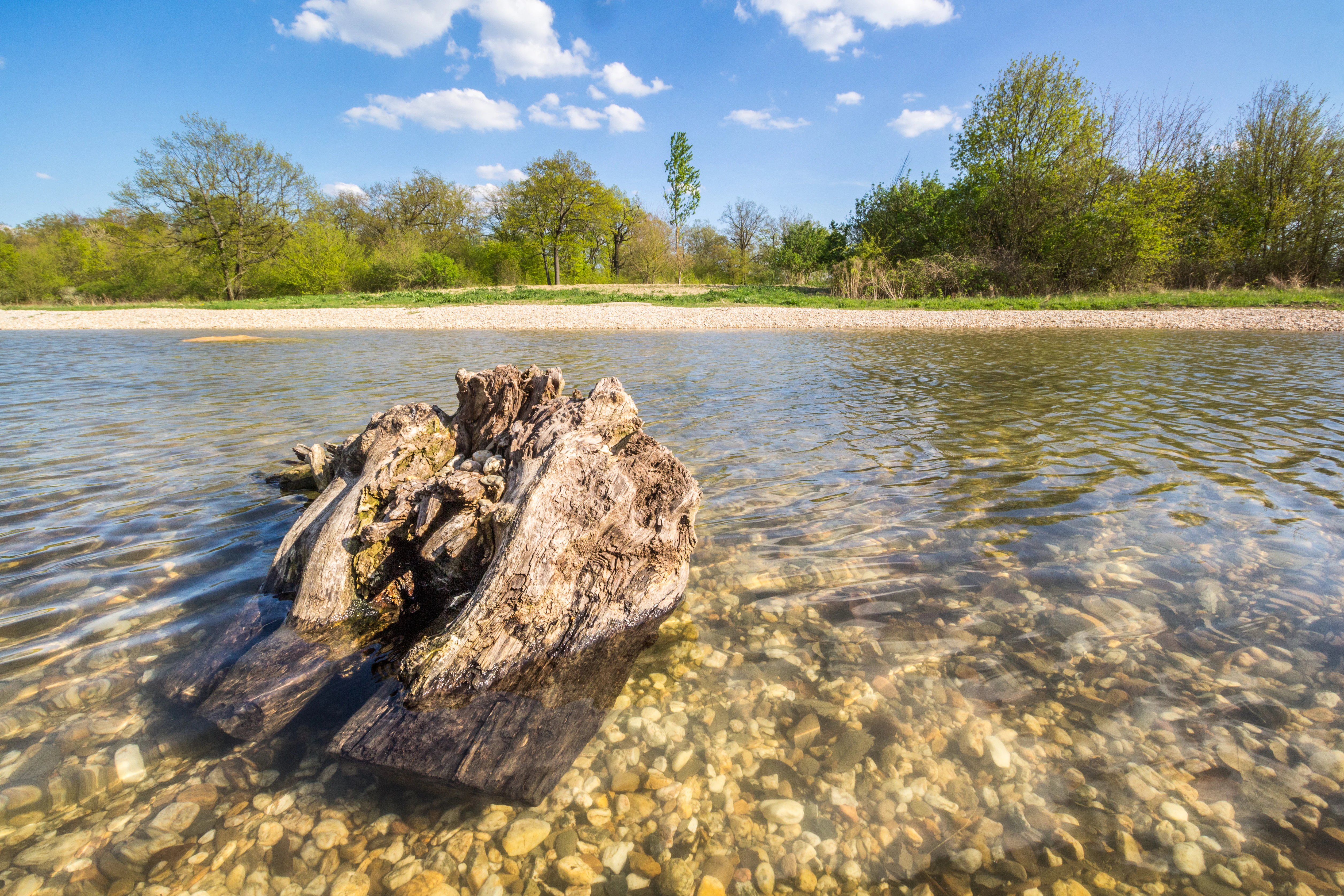
A weathered, partially submerged tree stump in the shallow, clear water of a pond, with a pebbly shore and green trees in the background under a blue sky.
A weathered tree stump sits in the shallows of Himmelteich, a pond in the Jena-Lichtenhain area.

Jenaer Forst history and protected-area timeline

The forest area today called Jenaer Forst carries a dense twentieth-century history, much of it driven by military and industrial use. In the 1930s, parts of the woodland were developed into accommodation for anti-aircraft artillery units of the Luftwaffe. From 1939 to 1945, the so-called 'Lager Forst' housed prisoners of war and forced laborers, and the plateau toward Jena and Waldschlößchen also saw barracks construction in 1944 to 1945 that was never completed. Carl Zeiss Jena operated a worker and prisoner-of-war camp in the forest area during the same period, and numerous quarrying operations took place across the landscape.

After the war, the Soviet military occupied and used the area intensively. Between 1960 and 1990, the 8th Guards Army stationed Scud-B and later SS-23 Spider missile systems in the Jenaer Forst. The site also included barracks complexes and associated infrastructure, parts of which were later repurposed as a first reception center for asylum seekers. These successive waves of use left an unusually dense material legacy: abandoned buildings, filled cellars, drainage ditches, air-raid shelters, remnants of driving training tracks, derelict sports facilities, and large volumes of buried waste.

In 2008, a substantial portion of the wider Jenaer Forst was placed under nature protection, receiving the official designation NSG 452. Since then, significant efforts have been directed at renaturation and remediation. Unused buildings have been demolished, old landfills have been consolidated and capped to remove their status as Altlast (active contaminated sites), and new groundwater monitoring wells have been installed toward Jena. The former 'Schott-Deponie' has been stabilized and sealed, though it remains classified as an Altablagerung capable of reverting to contaminated-site status if pollutants escape. Additional landfills near the village of Coppanz, partly filling former quarries and valley notches, are also being addressed.

A 2025 discovery of a presumed Soviet anti-tank mine highlighted how much of the forest's military-era material legacy remains to be dealt with. The establishment of the Forum Natura at Otto-Schott-Platz in 2022 marked a turning point, providing a dedicated public-facing venue for interpreting the forest's natural and cultural history. Throughout these changes, the reserve has continued to function as both a working forest and a local recreation area for Jena.

Jenaer Forst landscape and geographic character

Jenaer Forst occupies a forested limestone plateau west of Jena, with the Saale river valley marking its eastern edge. The terrain is shaped by its underlying geology: relatively thin, dry soils over calcareous parent material create a mosaic of woodland, edge habitats, and historically cleared patches. This geological setting, combined with the plateau's topography, is responsible for the reserve's dry, herb-rich character and supports the botanical specialism of the site.

The protected area is closely bounded by major transport corridors that also shape its landscape context. The Bundesstrasse 7 runs along the northern edge, the A4 autobahn skirts the south, and the Saale and the L2308 road define the eastern boundary. Small valleys, old quarry workings, former barracks sites, and remediated landfill areas punctuate the plateau, producing a varied, layered terrain that combines natural woodland with visible traces of past human activity.

Distinctive landscape features include artificially created ponds added as part of restoration work, such as the Himmelteich, and the avenue leading to the Bismarckturm, which provides one of the more recognizable cultural vistas at the forest's edge. The Otto-Schott-Platz, while technically outside the NSG boundary, functions as an important recreational threshold zone where visitors transition between the urban environment and the forest landscape.
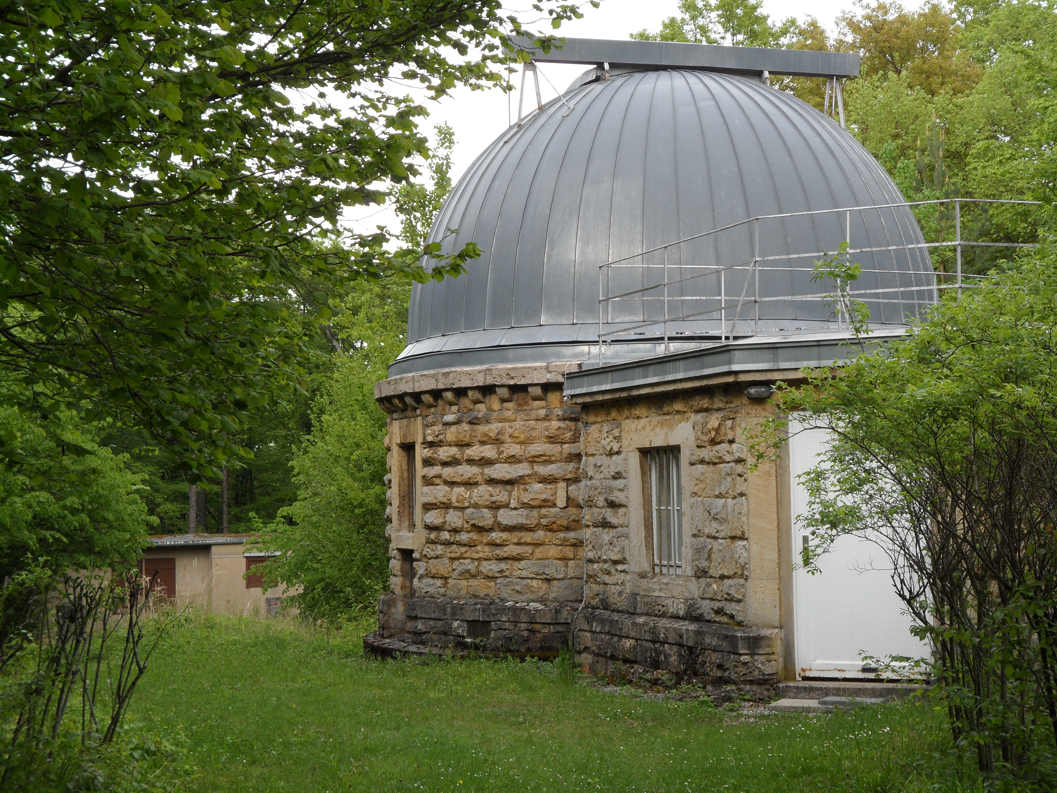
A round, stone-built observatory with a metallic dome roof, surrounded by green trees and foliage in the Jenaer Forst.
The historic Forststernwarte observatory building situated in the Jenaer Forst.

Jenaer Forst ecosystems, habitats, and plant life

The ecological character of Jenaer Forst is defined by its dry, calcareous woodland and associated edge habitats. The combination of limestone bedrock, thin soils, and historical openings in the forest canopy creates conditions that favor light-demanding, base-rich plant communities. This is the foundation for the reserve's most distinctive flora, including several orchid species that are regionally uncommon and a focus of conservation attention.

Woodland structure across the reserve varies from closed mature forest to more open, regenerating areas where recent renaturation work has altered light and ground conditions. The creation of ponds, the removal of derelict buildings, and the gradual restoration of former settlement and landfill sites have introduced new microhabitats, including wet features and bare ground, that complement the older woodland habitats. These interventions actively broaden the ecological profile of the reserve rather than merely preserving a static condition.

The reserve is integrated into a broader mosaic of protected sites in the Jena region, including the Kernberge und Wöllmisse, the Leutratal und Cospoth, the Hufeisen-Jenzig, and the Spitzenberg area. Together, these sites create a connected network of calcareous, slope, and forest habitats that supports biodiversity across the wider Saale-Holzland landscape.

Jenaer Forst wildlife and species highlights

The woodland and edge habitats of Jenaer Forst support a varied fauna, with notable concentrations of species tied to calcareous woodland structure. Several bat species occur in the reserve, supported by the mosaic of mature trees, old buildings awaiting demolition, and underground or sheltered features. The bat fauna is part of why the area is recognized as important for species management, in line with the reserve's IUCN Category IV status.

Breeding bird communities in the forest include threatened species that respond to the mix of closed canopy, edge zones, and open regenerating areas. Habitat heterogeneity created by past land use and current renaturation is a defining feature of the ornithological value of the site, rather than any single habitat type alone.

Invertebrate diversity is closely tied to the orchid-rich calcareous flora and to the open, warm microsites scattered across the plateau. The reserve is recognized as a regionally important site for rare insects, whose presence is closely linked to the conservation management of flowering plants and small-scale disturbance regimes. Together, the bat, bird, and invertebrate communities reflect the wider significance of the site as a habitat and species management area.

Jenaer Forst conservation status and protection priorities

Jenaer Forst was designated as a nature reserve in 2008 under the German Naturschutzgebiet framework, with the official identifier NSG 452. It is classified as an IUCN Category IV area (Habitat/Species Management Area), a designation that reflects its role in actively managing habitats and species rather than leaving them untouched. Conservation in the reserve is shaped by a commitment to combine ecological restoration with continued forest use and public recreation.

A central thread of conservation work is the remediation of contaminated and disturbed sites. Old landfills, including the Schott-Deponie, have been stabilized, sealed, and reclassified as Altablagerungen, with groundwater monitoring infrastructure maintained to detect any future pollutant migration. Multiple former landfills and quarry fills near Coppanz remain part of the long-term management agenda. The ongoing demolition of derelict buildings and removal of settlement remains has been a major component of restoring functional habitat.

Ecologically, the reserve is significant for dry calcareous woodland and its associated orchid flora, as well as for bat, breeding bird, and invertebrate communities that depend on habitat heterogeneity. Conservation management balances the protection of these specialist communities with the broader functions of the forest, including its role as a local recreation area, its value as working woodland, and its role within a wider network of protected sites in the Saale-Holzland-Kreis and the city of Jena.

Jenaer Forst cultural meaning and human context

The cultural identity of Jenaer Forst is inseparable from its layered twentieth-century history. Between the 1930s and the early 1990s, the forest hosted successive waves of military and paramilitary use, including anti-aircraft training, prisoner-of-war and forced-labor camps during World War II, and prolonged Soviet occupation with missile systems stationed on the plateau. The Carl Zeiss 'Lager Forst' camp is one of the most significant pieces of this history. Ruins of barracks, burial sites, and abandoned infrastructure remain visible reminders of these periods.

Alongside this difficult heritage, the forest carries a more celebratory cultural layer. The 1874 Forstturm observation tower, the Forststernwarte observatory, the avenue to the Bismarckturm, and the Schullandheim Stern together form a rich set of educational, recreational, and commemorative landmarks. The Otto-Schott-Platz and the Forum Natura visitor center, opened in 2022, mark an effort to interpret this combined natural and cultural landscape for the public. The avenue leading to the Bismarckturm has become a recognizable cultural image associated with the reserve.

Top sights and standout views in Jenaer Forst

The highlights of Jenaer Forst converge around three themes: ecological distinctiveness, layered cultural history, and active restoration. Ecologically, the dry calcareous woodland with its orchid-rich flora, bat populations, and threatened breeding birds defines the reserve's natural identity. Culturally, the forest combines Ottoman-era and Bismarck-era monuments, the historic Forstturm, and the Forststernwarte, all set within a landscape still bearing traces of wartime camps and Cold War missile deployments. Restoration-wise, ongoing remediation of landfills, demolition of derelict buildings, and the creation of new habitat features such as the Himmelteich demonstrate a rare combination of ecological ambition and direct, visible intervention.

Best time to visit Jenaer Forst

Jenaer Forst can be visited throughout much of the year, but spring and early summer are particularly rewarding for the botanical character of the reserve. This is when the calcareous woodland flora, including the orchid-rich sites, is most visible and the forest edges and openings are at their most floristically active. Warmer months also support the most active bat, bird, and insect activity, making wildlife observation more feasible.

Autumn brings a different appeal, with mature woodland color, mushroom-and-forage interest in a working forest, and quieter trails. Winter visits are possible but should account for the seasonal character of forest weather in the Saale region and shorter daylight hours; many visitors find the cultural landmarks such as the Bismarckturm especially atmospheric during this period. The surrounding hiking network and the Otto-Schott-Platz give visitors flexibility to combine protected-area exploration with broader Jena-area recreation.


Monthly climate preview

Long-term monthly temperature averages and precipitation records for Jenaer Forst

Jenaer Forst Climate Normals and Measured Annual Temperature Patterns

Jenaer Forst records measured long-term temperature swings and precipitation patterns across twelve recorded months from representative elevation sampling. Examining the complete monthly climate normals reveals full seasonal shifts and detailed precipitation trends across the protected area.
Annual mean9 °C
-1 °C19 °C
Jan-1°
Feb
Mar
Apr
May13°
Jun17°
Jul19°
Aug19°
Sep14°
Oct
Nov
Dec
Warmest month
July

18.9 °C

Coolest month
January

-1 °C

Wettest month
July

2.5 mm/day

Driest month
April

1.3 mm/day

Park location guide

Geography guide, regional context, and park location map for Jenaer Forst

Jenaer Forst park geography, regions, and map view in Germany

Understand where Jenaer Forst sits in Germany through a broader geographic reading of the surrounding landscape, nearby location context, and its mapped position within the national park landscape.

How Jenaer Forst fits into Germany

Germany is a federal republic in Western and Central Europe with a population of over 83 million across sixteen constituent states. It is Europe's largest economy by nominal GDP and a major global exporter and importer. The capital is Berlin, and the country borders Denmark, Poland, Czech Republic, Austria, Switzerland, France, Luxembourg, Belgium, and the Netherlands.

Wider geography shaping Jenaer Forst in Germany

Germany is located in Western and Central Europe, spanning 357,022 km². It borders Denmark to the north, Poland and the Czech Republic to the east, Austria and Switzerland to the south, and France, Luxembourg, Belgium, and the Netherlands to the west. The country has coastlines on the Baltic Sea and North Sea to the north, with the Alps located in the southern region.

Map view of Jenaer Forst

Use this park location map to pinpoint Jenaer Forst in Germany, understand its exact geographic position, and read its mapped placement within the surrounding landscape more clearly.

Pigeon | © OpenStreetMap contributors

Location context for Jenaer Forst

Thuringia
Recorded earthquake history

Explore the Historical Earthquake Records for the Jenaer Forst Nature Reserve

Gain insight into the seismic history of the Jenaer Forst region through a structured catalogue of recorded events. Use this repository to examine historical data, including event magnitude and proximity to the reserve, as part of the broader MoriAtlas geographic information system.

Jenaer Forst Earthquake History

Catalogued events

1 event

Strongest magnitude

Magnitude 4.9

Most recent event

Sep 11, 1996

This history includes earthquakes recorded inside the park or within 50 km of its borders

Explore protected area views, calcareous woodland habitats, and forest terrain characteristics.

Jenaer Forst Photos and Landscape Scenery: Visualizing the Protected Limestone Plateau

Visual documentation of Jenaer Forst reveals the complex terrain of its limestone plateau, dry calcareous woodlands, and restored habitat features across the Thuringian landscape. Examining these protected area images provides a clearer understanding of the ecological restoration work, topography, and natural environment shaping the modern forest reserve.

A weathered, partially submerged tree stump in the shallow, clear water of a pond, with a pebbly shore and green trees in the background under a blue sky.

A dirt path lined with tall, leafless trees at sunset, with golden light filtering through the branches and illuminating the forest floor.

A round, stone-built observatory with a metallic dome roof, surrounded by green trees and foliage in the Jenaer Forst.

Park atlas

Compare adjacent Thuringian nature reserves and connected limestone plateau geography.

Parks Near Jenaer Forst: Explore Nearby Protected Areas and Regional Woodlands

Browse protected areas surrounding Jenaer Forst to compare dry calcareous woodlands and regional forest reserves. Continuing into adjacent natural landscapes reveals broader ecological patterns across the Thuringian terrain.
Nature reserveThuringia
About 2.1 km away#1 closest

North

Windknollen Nature Reserve: Mapping Protected Limestone Landscapes in Thuringia

Examining the plateau geography and former training site boundaries

The Windknollen nature reserve occupies a distinct position on the Muschelkalk limestone plateau near Jena. Its protected status reflects an evolution from historical battlefield use to a formal conservation area within the National Natural Heritage framework. The terrain is defined by exposed; dry-adapted vegetation across 185 hectares of highland geography.

Area
1.851 km²
Established
1997
IUCN
IV
Nature reserveThuringia
About 2.5 km away#2 closest

Southeast

Leutratal und Cospoth Nature Reserve: Mapping Calcareous Grasslands in Thuringia

A study of limestone slopes and orchid-rich habitats in central Germany

Leutratal und Cospoth serves as a prime example of protected Muschelkalk landscape in Thuringia. This reserve captures the complex transition between open grasslands, scrub, and beech forests within the middle Saale valley, offering deep insights into the region's unique geological and botanical heritage.

Area
5.829 km²
Established
1961
IUCN
IV
Relief
Upland
A horizontal watercolor illustration showing green rolling hills, distant light green ridges, and sparse trees against a white background.
Nature reserveThuringia
About 4.8 km away#3 closest

Southeast

Spitzenberg-Schießplatz Rothenstein-Borntal Nature Reserve and Saale Valley Geography

Protected forest and grassland terrain in Thuringia

Spitzenberg-Schießplatz Rothenstein-Borntal is a protected nature reserve in Thuringia, covering hundreds of hectares of forest slopes, plateaus, and open clearings. This reserve is recognized for its unusual structural diversity, ranging from closed valley woodland to sun-exposed semi-dry grassland, providing essential habitat within the middle Saale valley region.

Area
5.542 km²
Established
1961
IUCN
IV
Nature reserveWeimarer Land
About 10 km away#4 closest

West

Seeteich Blankenhain Nature Reserve: Geographic Map and Protected Area Context

Wetland landscape situated in the Weimarer Land district

Seeteich Blankenhain is a distinct nature reserve in Germany, characterized by its historic pond and surrounding moist lowland ecosystems. This site remains a focal point for ecological research and conservation, offering a layered landscape of reed zones and woodland that supports a diverse bird community. Its presence within the regional geography of Weimarer Land highlights the importance of small-scale wetland preservation in the Thuringian landscape.

Established
1991
Relief
Lowland
Access
Access unknown
Scope
Terrestrial
Nature reserveThuringia
About 12 km away#5 closest

Northeast

Lohholz Nature Reserve: Protected Forest and Meadow Mosaic in Thuringia

Mapped deciduous woodlands and river valley meadow geography

Lohholz constitutes an isolated nature reserve in Thuringia, showcasing a distinct mosaic of broadleaf forest and traditional orchard meadows. The terrain slopes toward the Saale river valley, featuring varied grassland communities and a vital spring-fed brook. This protected area offers a look at forest preservation within a landscape predominantly utilized for agricultural purposes.

Area
0.304 km²
Established
1995
IUCN
IV
Relief
Upland
Protected landscapeThuringia
About 17 km away#6 closest

West

Landschaftsschutzgebiet Mittleres Ilmtal: Protected Landscape Geography and Map Discovery

Thuringia regional atlas and protected area profile

Gain insight into the diverse topography of Landschaftsschutzgebiet Mittleres Ilmtal, which spans roughly 150 square kilometers. This protected landscape is characterized by its dramatic shifts from Buntsandstein forests in the Tannrodaer Sattel to the elevated Muschelkalk escarpments, offering a detailed case study in German mid mountain geography.

Area
150 km²
Relief
Upland
Climate
Temperate
Access
Access unknown
Nature reserveThuringia
About 18 km away#7 closest

Northwest

Südhang Ettersberg Nature Reserve: Geographic Overview and Protected Area Boundaries

A prominent protected ridge landscape in central Thuringia

Südhang Ettersberg encompasses 408 hectares of south-facing slopes, creating a unique microclimate in the Weimarer Land district. This nature reserve serves as a benchmark for dry grassland and thermophilic woodland conservation in central Germany, offering a distinct mapped landscape that stands out from the surrounding agricultural lowlands.

Area
4.083 km²
Established
1997
IUCN
IV
Relief
Upland
A soft watercolor painting of a rolling landscape with green hills, scattered trees, and pale, earthy foreground textures.
Nature reserveThuringia
About 24 km away#8 closest

South

Buchenberg bei Krölpa Nature Reserve: Mapped Geography and Protected Landscape Context

A restored limestone quarry habitat located in Thuringia, Germany.

Buchenberg bei Krölpa stands as a regionally significant nature reserve located east of Krölpa. Formerly a site of limestone extraction, the protected area now functions as a managed habitat, characterized by its broken, stepped terrain and slopes that host native orchid species and dry grassland vegetation within the broader Thuringian countryside.

Area
0.201 km²
Established
1996
IUCN
IV
Relief
Upland

Common questions about visiting, size, designation, and location context for Jenaer Forst

Jenaer Forst FAQs for park facts, access, geography, and protected area context

Find quick answers about Jenaer Forst, including protected-area facts, park geography, trail and visitor context, and how the park fits into its surrounding country and regional landscape.
MoriAtlas Explorer

Continue Your Protected Areas Search Across the Global Atlas

Deepen your exploration by continuing the structured search for national parks and protected areas worldwide. Utilize the comprehensive filtering capabilities to compare different conservation landscapes and refine your understanding of global park geography. Discover more about the distribution and characteristics of protected natural areas.

Global natural geography