Mori Atlas logo
Nature reserveKalltal

A vital ecological corridor featuring upland brook systems, marshland, and bog habitats.

Kalltal Nature Reserve and Protected Valley Landscapes in North Rhine-Westphalia, Germany

(Naturschutzgebiet Kalltal)

The Kalltal nature reserve represents a significant protected area within the Eifel region of North Rhine-Westphalia. Spanning roughly 54 hectares, this site preserves an unmodified gravel-bottomed stream and a complex mosaic of wet meadows, moor fragments, and forest patches. As a key node in the Natura 2000 ecological network, it serves as a critical habitat link between the Belgian High Fens and the Rur valley system.

nature reservestream valleywet meadowmoorlandbog habitatEifel

Kalltal

Nature reserve

Park overview

Structured park overview, official facts, and landscape profile for Kalltal Nature Reserve

Kalltal Nature Reserve park facts, protected area profile, and essential visitor context

Review the core facts for Kalltal Nature Reserve, including designation, size, terrain, visitor scale, habitats, and operating context in one park-focused overview.

About Kalltal Nature Reserve

Kalltal Nature Reserve is a narrow, ecologically focused protected area in the northern Eifel region of western Germany. It lies within the municipality of Monschau, between the villages of Konzen and Lammersdorf, and stretches along the upper reaches of the Kall stream close to the German Belgian border. Although it covers only about 54.5 hectares, the reserve concentrates on a particularly valuable combination of habitats: an unchanneled, clean upland brook, wet and boggy meadows, and small forested patches dominated by spruce plantation and bog birch.

The reserve was designated in 1998 through the Monschau landscape plan. Before that designation, parts of the area had already been protected under earlier nature reserve labels. By formalizing the status of the entire two-kilometer stream stretch and the surrounding wetlands, the plan aimed to safeguard one of the more intact valley ecosystems in the region against drainage, agricultural intensification, and forestry conversion. Administratively, the area is overseen by the lower landscape authority (Untere Landschaftsbehörde) of the Städteregion Aachen.

Ecologically, the reserve is notable because it is entirely embedded within the larger Natura 2000 site DE-5303-302 Kalltal und Nebentäler. This means that the management of the small national-level reserve is coordinated with a broader European Habitats Directive framework that extends further along the Kall and its tributary valleys. The reserve also connects eastward to the neighboring Oberes Kalltal mit Nebenbächen reserve in the Simmerath municipality, together forming a continuous protected corridor along the upper Kall.

The landscape is shaped by the stream itself. The Kall rises in Belgium and enters the reserve as a shallow, gravel-bedded brook only about a meter wide and ten to twenty centimeters deep. Its clear, oxygen-rich water is signalled by the presence of caddisfly larvae in the streambed. On both sides of the watercourse, abandoned or low-intensity grasslands have developed into species-rich wet meadows, locally interspersed with boggy zones and short stretches of woodland. The interplay of flowing water, wet soil, and mosaicked vegetation gives the reserve a character that is rich in botanical and faunal detail despite its modest size.

Quick facts and research context for Kalltal Nature Reserve

Kalltal Nature Reserve covers about 54.5 hectares in the municipality of Monschau in the Städteregion Aachen, North Rhine-Westphalia. It was officially designated in 1998 under the Monschau landscape plan and carries the German nature reserve code ACK-061. The reserve lies entirely within the larger Natura 2000 Habitats Directive site DE-5303-302 known as Kalltal und Nebentäler.

The area extends along roughly two kilometers of the upper Kall, a stream that rises in Belgium and enters the reserve from the west. Together with the adjacent Oberes Kalltal mit Nebenbächen reserve in Simmerath, it forms part of a broader protected valley system stretching between the High Fens and the Rur valley.

Protection and recognition

Examine documented conservation data and official protected area records for Kalltal.

Kalltal Protection Status and International Recognition Data

Kalltal holds recorded entries within global protected area databases to verify conservation status and management frameworks. Review structured administrative records for complete verification details.

Protection details

WDPA ID
318625
Park context

Deeper park guide and search-rich context for Kalltal Nature Reserve

Kalltal Nature Reserve history, landscape, wildlife, and travel context

Explore Kalltal Nature Reserve through its history, landscape character, ecosystems, wildlife, conservation priorities, cultural context, and seasonal travel timing in a structured park guide built for atlas discovery and search intent.

Why Kalltal Nature Reserve stands out

Kalltal is best known for its largely unmodified upper stream course of the Kall and the unusually intact mosaic of wet grassland, moor fragments, and small forest patches that surround it. The combination of a clean, gravel-bottomed brook with adjacent species-rich bogs and meadows is the defining character of the site. It is also recognized as an important ecological link in the transboundary habitat network between the Belgian High Fens and the Rur valley. The presence of protected species such as the Eurasian beaver, kingfisher, and whinchat reinforces its role as a refuge for moisture-dependent wildlife within a heavily used regional landscape.
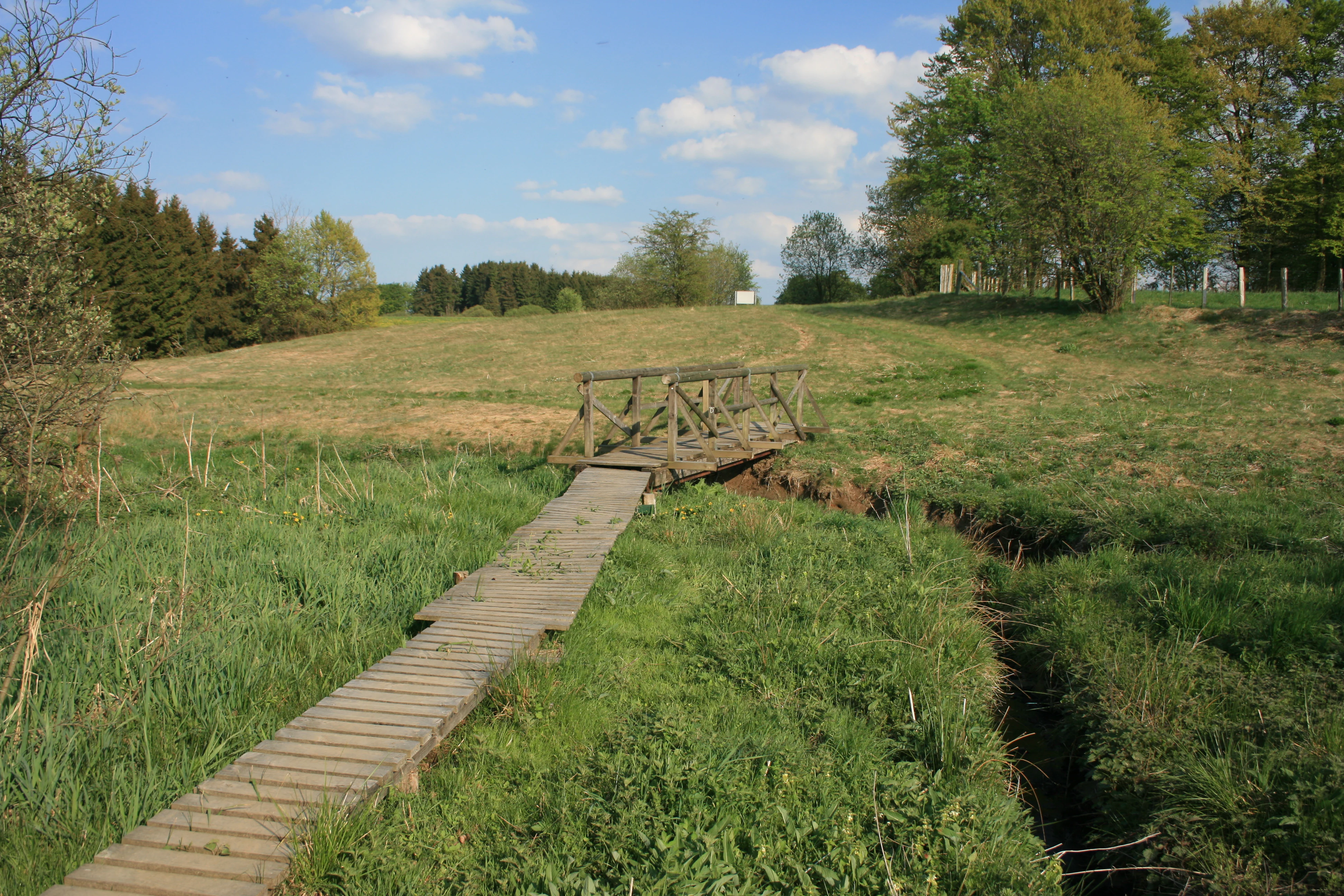
A wooden footbridge and boardwalk crossing over a narrow stream through a grassy meadow.
A wooden footbridge crossing a small stream in the Kalltal nature reserve.

Kalltal Nature Reserve history and protected-area timeline

The area that is today the Kalltal Nature Reserve was gradually recognized and protected in stages. Parts of the valley had already been designated as separate nature reserves under earlier designations before the unified Kalltal reserve was created. In 1998, the Monschau landscape plan brought these fragments together into a single, coherent protection framework covering roughly 54.5 hectares of the upper Kall valley between Konzen and Lammersdorf.

The 1998 designation established the reserve under the German Naturschutzgesetz with the code ACK-061, managed by the Untere Landschaftsbehörde of the Städteregion Aachen. Its creation reflected a broader interest in maintaining near-natural stream courses and their associated wet meadows in a region where many valleys had been drained, straightened, or converted to intensive agriculture. The reserve's inclusion in the larger European Habitats Directive site DE-5303-302 Kalltal und Nebentäler later embedded it in the cross-border Natura 2000 ecological network, reinforcing its conservation status beyond national-level protection.

Kalltal Nature Reserve landscape and geographic character

The landscape of Kalltal is defined by the narrow valley of the upper Kall and the gentle relief of the surrounding Eifel uplands. The reserve follows a roughly two-kilometer stretch of the stream between Konzen and Lammersdorf, while the western edge reaches the B 258 federal road at the German Belgian border. In the east, the protected area connects directly with the Oberes Kalltal mit Nebenbächen reserve in the Simmerath municipality, creating a continuous valley corridor.

The stream itself shapes the terrain. The Kall, called Kallbach in its upper course, rises in Belgium and enters the reserve as a shallow, unchanneled brook. Its bed is gravelly, its depth only ten to twenty centimeters, and its width around one meter, producing the small-scale pool and riffle structure typical of upland brooks. Around the stream, the relief flattens into a strip of wet meadows and boggy depressions bordered by short sections of woodland.

Forests within the reserve are limited and patchy. Most tree cover consists of spruce plantations, while the wetter, boggy sections support stands of bog birch that grade into open mire vegetation. Although the relief is modest, the contrast between flowing water, soft wet ground, and small woodland patches gives the valley a distinctly layered appearance that rewards close observation rather than broad panoramic views.

Kalltal Nature Reserve ecosystems, habitats, and plant life

Ecologically, Kalltal is a small but unusually rich valley ecosystem built around the interaction of stream, wet grassland, and mire habitats. The unaltered streambed maintains clean, oxygen-rich water indicated by the presence of caddisfly larvae, supporting the broader food web of the valley.

On both sides of the Kall, formerly cultivated grasslands have largely been abandoned and developed into species-rich wet meadows with localized boggy patches. The wet and moist grassland is rich in rushes and sedges, and supports larger stands of bistort along with smaller populations of marsh cinquefoil, chickweed wintergreen, bog asphodel, marsh trefoil, and common spotted orchid. Boggy areas are characterized by cottongrass and sphagnum mosses, giving these fragments a distinctly northern, peatland character for a central European setting.

Woodland is present only in smaller patches. Spruce plantations dominate the drier slopes, while the wettest sections carry bog birch stands that blend into the open mire. The resulting mosaic of habitats within a narrow valley strip supports a wide range of moisture-loving species and gives the reserve a botanical density that exceeds what its modest size would suggest.

Kalltal Nature Reserve wildlife and species highlights

The wildlife significance of Kalltal is closely tied to its combination of clean running water, wet meadows, and boggy ground. The reserve is an important refuge for several protected and otherwise rare species in the western Eifel landscape.

Wetland and stream-associated species are central to the site's ecological profile. The Eurasian beaver is present along the Kall, along with bat species such as the greater mouse-eared bat and the pond bat, which use the valley's structural diversity for foraging and roosting. Birdlife includes the kingfisher, associated with the clean gravel-bedded stream, and the whinchat, a ground-nesting bird of open wet meadows and scrub edges. Together, these species signal a functioning valley ecosystem with intact aquatic, grassland, and woodland elements rather than a single dominant habitat type.

Kalltal Nature Reserve conservation status and protection priorities

Conservation in Kalltal focuses on maintaining a near-natural stretch of the upper Kall together with the stream-dependent grasslands and mire fragments around it. The reserve's established purpose is to protect an unaltered flowing water habitat and the surrounding wet to boggy grasslands as habitat for several threatened plant and animal species.

The site plays an important role within the transboundary biotope network connecting the High Fens (Hohes Venn) on the Belgian side with the Rur valley in Germany. By safeguarding an unbroken stretch of the Kall near its source, the reserve helps maintain continuity for species that depend on running water and wet habitats across administrative boundaries.

The reserve also gains additional protection through its inclusion in the Natura 2000 network. The entire area lies within the larger Habitats Directive site DE-5303-302 Kalltal und Nebentäler, which extends conservation obligations beyond the national nature reserve framework. This layered protection, from the 1998 national designation through European-level recognition, supports long-term management aimed at preventing drainage, agricultural intensification, or forestry conversion that could otherwise degrade the valley's hydrology and habitat structure.

Kalltal Nature Reserve cultural meaning and human context

Kalltal lies in a traditional rural landscape of the northern Eifel, where small villages such as Konzen and Lammersdorf have long shaped land use along the upper Kall valley. The presence of a transboundary reserve close to the Belgian border reflects the region's position between two countries with shared ecological and cultural traditions in upland farming.

The reserve's character is closely tied to the decline of traditional valley agriculture. Many of its species-rich meadows developed on land that was once mown or grazed, and their current botanical richness is partly a result of reduced or abandoned use. This makes the reserve both a natural protection site and a quiet record of changing rural land use in the western Eifel.

Top sights and standout views in Kalltal Nature Reserve

The defining highlight of Kalltal is its near-natural upper stretch of the Kall, framed by a tight mosaic of wet meadows, bog fragments, and small forest patches. Despite its small size, the reserve hosts a striking botanical concentration, including bog asphodel, marsh trefoil, cottongrass, sphagnum mosses, and the common spotted orchid.

Equally important is its role as a transboundary ecological link. Embedded in the Natura 2000 site Kalltal und Nebentäler and connected eastward to the Oberes Kalltal mit Nebenbächen reserve, Kalltal functions as a vital node in the protected landscape corridor between the High Fens and the Rur valley.

Best time to visit Kalltal Nature Reserve

The valley has a distinctly seasonal character. Late spring and early summer typically offer the richest display of wetland flora, when wet meadow species and orchids are in flower and the stream is well supplied by spring rainfall. Summer brings greener, lusher vegetation along the valley strip, while autumn turns the bog birches and surrounding meadows into softer tones.

Because the reserve is a quiet, ecologically sensitive valley rather than a scenic viewpoint, low-impact visits during drier periods in late spring or summer are most suitable for experiencing the habitat. Wet, muddy ground in winter and the sensitivity of breeding birds in spring are reasons to avoid disturbing core zones during those seasons.

Monthly climate preview

Long-term representative coordinate records for monthly precipitation and average temperatures in Kalltal

Kalltal Climate Normals and Measured Annual Temperature Rhythm

Historical measurement points reveal a measured annual temperature and precipitation rhythm across Kalltal from representative coordinate sampling. Detailed monthly climate records provide comprehensive context for tracking long-term environmental patterns across the protected landscape.
Annual mean8 °C
0 °C17 °C
Jan
Feb
Mar
Apr
May11°
Jun15°
Jul17°
Aug17°
Sep13°
Oct
Nov
Dec
Warmest month
July

17 °C

Coolest month
January

-0 °C

Wettest month
December

3.1 mm/day

Driest month
April

1.9 mm/day

Park location guide

Geography guide, regional context, and park location map for Kalltal Nature Reserve

Kalltal Nature Reserve park geography, regions, and map view in Germany

Understand where Kalltal Nature Reserve sits in Germany through a broader geographic reading of the surrounding landscape, nearby location context, and its mapped position within the national park landscape.

How Kalltal Nature Reserve fits into Germany

Germany is a federal republic in Western and Central Europe with a population of over 83 million across sixteen constituent states. It is Europe's largest economy by nominal GDP and a major global exporter and importer. The capital is Berlin, and the country borders Denmark, Poland, Czech Republic, Austria, Switzerland, France, Luxembourg, Belgium, and the Netherlands.

Wider geography shaping Kalltal Nature Reserve in Germany

Germany is located in Western and Central Europe, spanning 357,022 km². It borders Denmark to the north, Poland and the Czech Republic to the east, Austria and Switzerland to the south, and France, Luxembourg, Belgium, and the Netherlands to the west. The country has coastlines on the Baltic Sea and North Sea to the north, with the Alps located in the southern region.

Map view of Kalltal Nature Reserve

Use this park location map to pinpoint Kalltal Nature Reserve in Germany, understand its exact geographic position, and read its mapped placement within the surrounding landscape more clearly.

Pigeon | © OpenStreetMap contributors

Location context for Kalltal Nature Reserve

North Rhine-Westphalia

Visual exploration of stream valleys, wet meadows, and upland habitats in the Eifel region

Kalltal Photos, Scenery, and Protected Landscape Views

Visual documentation of Kalltal reveals the intricate terrain of an unmodified upland stream valley, showcasing adjacent wet meadows, moor fragments, and protected bog habitats. Examining these detailed landscape photographs provides a deeper understanding of the ecological character, natural features, and delicate environmental mosaic defining the surrounding conservation corridor.

A wooden footbridge and boardwalk crossing over a narrow stream through a grassy meadow.

Park atlas

Discover related reserves, stream valleys, and connected Eifel habitats.

Exploring Parks Near Kalltal and Surrounding Protected Natural Landscapes

Browsing other protected areas near Kalltal reveals a wider network of upland stream valleys and wet meadow reserves across the region. Comparing these neighboring conservation zones provides a deeper understanding of transboundary habitats and local terrain.
A soft watercolor illustration showing a hazy, green landscape with a winding stream, distant hills, and low-lying vegetation on a white background.
Nature reserveNordrhein-Westfalen
About 1.4 km away#1 closest

East

Kranzbach und Kranzbruchvenn: Protected Nature Reserve and Bog Landscape in Nordrhein-Westfalen

Wetland stream valleys and historic military relic landscapes

Investigate the specialized wetland ecosystems of Kranzbach und Kranzbruchvenn, a nature reserve in Nordrhein-Westfalen known for its bog and fen habitats. The site offers a detailed case study of small-stream hydrology and the transformation of former Westwall dragon teeth structures into unique marsh environments.

Area
0.328 km²
Established
2002
IUCN
IV
A soft, horizontal watercolor painting of rolling green hills under a faint, warm-toned sky, with no sharp outlines.
Nature reserveNorth Rhine-Westphalia
About 2.2 km away#2 closest

Northeast

Lenzbach Nature Reserve: Protected Stream Valley and Habitat Connectivity in the Northern Eifel

Geographic atlas and ecological landscape context in North Rhine-Westphalia

Lenzbach Nature Reserve encompasses a near-natural headwater stream valley characterized by expansive wet grasslands and spring mires. As part of the Natura 2000 Kalltal und Nebentäler complex, the reserve serves as an essential ecological link within the cross-border landscape between Belgium and Germany, supporting diverse wetland flora and maintaining habitat connectivity for regional wildlife.

Area
0.11 km²
Established
1999
IUCN
IV
Nature reserveNorth Rhine-Westphalia
About 3 km away#3 closest

North

Wollerscheider Venn: Mapping the Protected Peatland and Bog Terrain of North Rhine-Westphalia

A specialized wetland reserve on the Eifel border high plateau

Located in the municipality of Simmerath, Wollerscheider Venn preserves essential fragments of raised bog and swamp woodland within the larger Hohes Venn ecosystem. This reserve protects diverse habitats including juniper heath and Nardus grassland, serving as a critical refuge for bog-specialist butterflies and dragonflies in the Eifel region. Its mapped landscape offers a clear view into the conservation of rare peatland environments across western Germany.

Area
0.42 km²
Established
1961
IUCN
IV
A watercolor painting showing a soft, pastel-colored landscape with a wetland in the foreground and gentle, rolling hills in the background.
Nature reserveNordrhein-Westfalen
About 3.5 km away#4 closest

Northwest

Hoscheider Venn mit Quellgebieten des Dreiläger- und Schleebaches Nature Reserve Atlas

Protected raised bog and glacial pingo terrain in North Rhine-Westphalia

Hoscheider Venn mit Quellgebieten des Dreiläger- und Schleebaches safeguards a representative upland moor environment on the western edge of the Eifel. The reserve includes diverse habitats ranging from nutrient poor bog pools to acidophilous forests, maintaining active restoration zones for regenerating wet heath and peatland ecosystems across its unique topographic mosaic.

Area
1.96 km²
Established
1982
IUCN
IV
Relief
Upland
A watercolor painting depicting a soft, panoramic landscape of a meandering stream valley with rolling hills, meadows, and scattered patches of trees.
Nature reserveNordrhein-Westfalen
About 4.8 km away#5 closest

Southwest

Kleines Laufenbachtal Nature Reserve: Geographic Atlas of an Eifel Stream Valley

Protected brook habitats and natural rock landscapes in North Rhine-Westphalia

Investigate the topographical features and habitat diversity of Kleines Laufenbachtal, an established nature reserve in the Eifel. This protected area showcases a dense assembly of wet grasslands, reed banks, and rocky slopes that anchor local ecological corridors within the Monschau landscape.

Area
0.13 km²
Established
1997
IUCN
IV
A horizontal watercolor painting showing a soft, stylized landscape with rolling green hills, distant purplish ridges, and grassy foreground elements on a white background.
Nature reserveNordrhein-Westfalen
About 4.9 km away#6 closest

South

Mittleres Rurtal mit den Felsbildungen der Perdsley und Wiselsley Protected Nature Reserve Map

Exploring the Rur valley river dynamics and cliff geology

Investigate the topographical features of the Mittleres Rurtal mit den Felsbildungen der Perdsley und Wiselsley, a critical nature reserve characterized by free flowing river segments and steep ravine forests. This overview outlines the ecological distribution of rock formations and riparian habitats across the Monschau region landscape.

Area
1.33 km²
Established
2003
IUCN
IV
Watercolor painting of a rolling stream valley with soft green hills and light water
Nature reserveStädteregion Aachen
About 5.5 km away#7 closest

Northeast

Kelzer- und Saarscher Bachtal: Protected Brook Valley Geography and Forest Terrain

Nature reserve exploration in the Städteregion Aachen landscape

The Kelzer- und Saarscher Bachtal nature reserve protects a vital network of brook valley habitats, including deciduous forest remnants, wet heath, and cascading stream sections. This area offers a clear look at local hydrologic restoration and the structural diversity found within the Eifel district, providing a focused view for those interested in regional protected-land geography.

Area
0.46 km²
Established
1999
IUCN
IV
A soft watercolor illustration of a rolling green landscape with flowering trees and distant forested hills, isolated on a white background.
Nature reserveNordrhein-Westfalen
About 6.1 km away#8 closest

South

Kluckbachtal Nature Reserve: Geographic Atlas and Protected Stream Valley Overview

Mapped riparian forest and orchard meadow habitats in Nordrhein-Westfalen

Kluckbachtal protects a distinctive valley segment between Rohren and Höfen, featuring a complex of stream beds, wet grasslands, and old oak and alder woodland. This nature reserve is recognized for its significant role in preserving Red List species and traditional cultural landscapes, offering a detailed look at the ecology of the northern Eifel region through its varied habitats.

Area
1.13 km²
Established
1997
IUCN
IV
Relief
Upland

Common questions about visiting, size, designation, and location context for Kalltal Nature Reserve

Kalltal Nature Reserve FAQs for park facts, access, geography, and protected area context

Find quick answers about Kalltal Nature Reserve, including protected-area facts, park geography, trail and visitor context, and how the park fits into its surrounding country and regional landscape.
MoriAtlas Explorer

Continue Your Protected Areas Search Across the Global Atlas

Deepen your exploration by continuing the structured search for national parks and protected areas worldwide. Utilize the comprehensive filtering capabilities to compare different conservation landscapes and refine your understanding of global park geography. Discover more about the distribution and characteristics of protected natural areas.

Global natural geography