

Mori Atlas logo
Nature reserveKoili - Mavrokolympos

Examining the complex ecological mosaic, limestone terrain, and mapped protected boundaries of the inland Cypriot interior.

Koili - Mavrokolympos Nature Reserve: A Detailed Geographic Atlas of Protected Mediterranean Landscapes

The Koili - Mavrokolympos nature reserve represents a critical protected terrestrial expanse within the interior of Cyprus. This mapped area showcases a dramatic intersection of diverse Mediterranean environments, ranging from rugged limestone-rich phrygana to sheltered riparian woodlands dominated by Oriental plane trees. The site provides essential habitat for numerous avian species and endemic flora, reflecting the complex hydrological and geological processes that shape the broader Cypriot landscape.

Natura 2000Mediterranean habitatsBird sanctuaryCypress forestsOriental plane forestsProtected landscape

Koili - Mavrokolympos

Nature reserve

Park overview

Structured park overview, official facts, and landscape profile for Koili - Mavrokolympos

Koili - Mavrokolympos park facts, protected area profile, and essential visitor context

Review the core facts for Koili - Mavrokolympos, including designation, size, terrain, visitor scale, habitats, and operating context in one park-focused overview.

About Koili - Mavrokolympos

Koili - Mavrokolympos functions as a vital ecological node within Cyprus's inland terrain. The protected landscape is defined by its highly varied topography, which allows sharply different habitat types to exist in close proximity. The substrate features exposed limestone outcrops that support specialized chasmophytic vegetation, giving way to lower elevations where pseudo-steppe formations and wet Mediterranean meadows dominate the open ground. This topographical complexity creates a rich structural environment for local ecosystems.

A defining characteristic of the area is the presence of mature, well-preserved Mediterranean forest patches. These include extensive stands of cypress (Acero-Cupression), traditional olive and carob woodlands, and a notable gallery forest dominated by the Oriental plane (Platanus orientalis) and sweetgum. The integration of these wooded zones with the open sclerophyllous scrublands, locally known as phrygana, supports a highly complex food web and offers shelter to species that rely on transitional environments.

As an integrated part of the European Union's Natura 2000 framework, the management and protection of the site are aligned with broad continental conservation goals. The overlapping legal designations applied to the territory reflect a sustained effort to maintain its status as an undisturbed zone, allowing natural successional processes to shape the landscape and sustain its exceptional biodiversity for the long term.

Quick facts and research context for Koili - Mavrokolympos

Koili - Mavrokolympos is a terrestrial Natura 2000 protected area located in Cyprus, covering approximately 296.76 hectares. Situated in the Mediterranean ecoregion, it holds the designations of a Special Protection Area (SPA), a Site of Community Importance (SCI), and a Special Area of Conservation (SAC). The site is home to over ten natural habitat types, including cypress and Oriental plane forests, and serves as a protected zone for dozens of bird and animal species.

Protection and recognition

Documented terrestrial protection history and Natura 2000 designation data

Koili - Mavrokolympos Protection Status and Official International Recognition

Koili - Mavrokolympos carries documented terrestrial protection status established in 2002 alongside official Natura 2000 network recognition. Official records outline the designation timeline and administrative boundaries for this protected area.

International recognition

Protection details

Protection scope
Terrestrial
Designated year
2002
Transboundary protection
No
Park context

Deeper park guide and search-rich context for Koili - Mavrokolympos

Koili - Mavrokolympos history, landscape, wildlife, and travel context

Explore Koili - Mavrokolympos through its history, landscape character, ecosystems, wildlife, conservation priorities, cultural context, and seasonal travel timing in a structured park guide built for atlas discovery and search intent.

Why Koili - Mavrokolympos stands out

The area is best known for its role as a major Special Protection Area under the European Natura 2000 framework, safeguarding an immense concentration of Mediterranean bird species and highly localized forest habitats. It is particularly distinguished by the coexistence of spiny phrygana, unique Oriental plane galleries, and ancient cypress woodlands, which collectively sustain a rich and diverse ecological community.

Koili - Mavrokolympos history and protected-area timeline

The formal conservation history of Koili - Mavrokolympos is closely tied to the implementation of the European Natura 2000 network in Cyprus. The area received its first major protected status in December 2002, when it was officially designated as a Special Protection Area (SPA) based on its significant populations of wild birds. This initial recognition laid the groundwork for a more comprehensive conservation mandate.

In May 2004, the site's importance was further formalized when it was classified as a Site of Community Importance (SCI), acknowledging the broader ecological value of its terrestrial habitats and specific animal and plant species. This status laid the foundation for its eventual transition into a Special Area of Conservation (SAC) in September 2015, cementing its role as a fully integrated, strictly protected zone within the national conservation network.

Koili - Mavrokolympos landscape and geographic character

The physical landscape of Koili - Mavrokolympos is characterized by the undulating, rocky terrain typical of the Cypriot interior. Limestone formations play a central role in shaping the visual and ecological profile of the area, creating steep slopes and rocky outcroppings that give structure to the environment. The varied elevation across the site contributes to a mosaic of microclimates, supporting both dry, sun-baked exposures and sheltered, moisture-retaining valleys.

Water dynamics are also a key feature of the topography, with seasonal river courses carving through the land. These waterways support riparian galleries and specialized wetland margins, offering a stark contrast to the dry, pseudo-steppe plains and the spiny, cushion-like formations of the local phrygana. The overall terrain provides a rugged, unmanicured backdrop for exploring the intersection of Mediterranean geological processes and natural forest dynamics.

Koili - Mavrokolympos ecosystems, habitats, and plant life

The ecological character of the site is profoundly Mediterranean, hosting a sophisticated blend of habitats that have adapted to the region's hot, dry summers and mild winters. Ten officially recognized natural habitat types are preserved here, representing a comprehensive cross-section of the island's biodiversity. The forested zones are particularly noteworthy, featuring classic Eastern Mediterranean associations like Cypress forests and forests of Quercus infectoria, alongside relict gallery forests of Oriental plane and Liquidambar.

Outside of the tree cover, the site supports extensive tracts of low-growing, highly resilient plant communities. Thermo-Mediterranean shrublands and specialized Sarcopoterium spinosum phryganas cover the sun-exposed hillsides, providing essential ground cover and foraging resources. The interplay between these dense scrublands, pseudo-steppes of annual grasses, and the scattered mature forests creates a layered, dynamic ecosystem that is highly characteristic of the eastern Mediterranean basin.

Koili - Mavrokolympos wildlife and species highlights

The site is predominantly recognized and protected for its exceptional avian diversity, serving as a crucial habitat for a wide array of bird species. With roughly 88 protected bird species identified within its boundaries, the area acts as a significant refuge for both resident populations and migratory visitors. Species range from birds of prey like the Eurasian sparrowhawk and common buzzard to smaller passerines, including the European roller and various endemic or localized Mediterranean warblers and wheatears, such as the Cyprus wheatear (Oenanthe cypriaca).

Beyond its feathered inhabitants, the fauna of Koili - Mavrokolympos includes an interesting representation of other taxonomic groups. The Egyptian fruit bat (Rousettus aegyptiacus) finds shelter in the area's rocky crevices and mature trees, establishing one of the key mammalian profiles for the protected zone. Additionally, the Jersey Tiger moth (Euplagia quadripunctaria) thrives in the undisturbed vegetation. The varied habitats also sustain dozens of other species, including 12 additional unlisted birds, 8 reptile species, and a handful of amphibians, illustrating a balanced and thriving wild community.

Koili - Mavrokolympos conservation status and protection priorities

Conservation efforts at Koili - Mavrokolympos are deeply integrated into the broader European ecological network through its Natura 2000 designations. The site is specifically managed and protected to ensure the long-term survival of 1 plant species, 88 bird species, 1 mammal species, and 1 invertebrate species. This specific focus ensures that regulatory frameworks address the precise biological needs of these target organisms.

By carrying the triple designations of an SPA, an SCI, and an SAC, the area benefits from a layered defense against habitat degradation and human disturbance. The protection of its varied Mediterranean habitats, from the rocky chasmophytic outcrops to the delicate riparian galleries, helps maintain ecological continuity across the region. This multi-tiered conservation approach secures the site's integrity, allowing its complex biological interactions to flourish without interruption.

Top sights and standout views in Koili - Mavrokolympos

Koili - Mavrokolympos offers a remarkable concentration of Mediterranean biodiversity within a compact terrestrial footprint. Its most compelling feature is the intersection of ten distinct natural habitat types, seamlessly weaving together arid phrygana, mature cypress forests, and wet Oriental plane woodlands. This convergence of environments supports nearly ninety officially protected bird species, positioning the area as a premier destination for ornithological conservation in Cyprus. The presence of the endemic plant Scilla morrisii and the sheltered populations of the Egyptian fruit bat further elevate its status as an indispensable sanctuary for Eastern Mediterranean wildlife.
Monthly climate preview

Long-term representative temperature and precipitation averages for Koili - Mavrokolympos in Cyprus.

Koili - Mavrokolympos Climate Normals and Weather by Month

Representative coordinates record long-term monthly temperature and precipitation variations across the year at an elevation of 333.95 meters. Exploring the complete twelve-month climatology profile reveals the detailed annual rhythm of averages measured from 1991 to 2020.
Annual mean19 °C
11 °C27 °C
Jan11°
Feb11°
Mar13°
Apr16°
May20°
Jun24°
Jul27°
Aug27°
Sep25°
Oct21°
Nov17°
Dec13°
Warmest month
August

27.2 °C

Coolest month
January

11.1 °C

Wettest month
December

2.8 mm/day

Driest month
July

0.1 mm/day

Park location guide

Geography guide, regional context, and park location map for Koili - Mavrokolympos

Koili - Mavrokolympos park geography, regions, and map view in Cyprus

Understand where Koili - Mavrokolympos sits in Cyprus through a broader geographic reading of the surrounding landscape, nearby location context, and its mapped position within the national park landscape.

How Koili - Mavrokolympos fits into Cyprus

Cyprus is an island nation in the eastern Mediterranean Sea, positioned at the crossroads of Europe, Africa, and Asia. The Republic of Cyprus governs the southern portion of the island, with Nicosia as its capital and largest city. The island has a complex political situation due to the Turkish occupation in the north and contains British military bases in the south. Cyprus gained independence from Britain in 1960 and is a member of the European Union.

Wider geography shaping Koili - Mavrokolympos in Cyprus

Cyprus is an island located in the eastern Mediterranean Sea, off the coast of the Levant in West Asia. The island lies approximately 75 km south of Turkey, 105 km west of Syria, and 380 km north of Egypt. The terrain varies from mountainous regions in the north and interior to plains and coastal areas. The Troodos Mountains dominate the central and southwestern part of the island. The island has no land borders as it is entirely surrounded by sea.

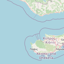
Map view of Koili - Mavrokolympos

Use this park location map to pinpoint Koili - Mavrokolympos in Cyprus, understand its exact geographic position, and read its mapped placement within the surrounding landscape more clearly.

Pigeon | © OpenStreetMap contributors
Recorded earthquake history

Examine Recorded Earthquake History Near Koili - Mavrokolympos

Consult the MoriAtlas seismic catalogue to view documented earthquakes associated with the Koili - Mavrokolympos nature reserve. Review historical event data including magnitude, depth, and geographic location relative to the park boundaries for a clearer understanding of local seismic patterns.

Koili - Mavrokolympos Earthquake Records

Catalogued events

328 events

Strongest magnitude

Magnitude 6.8

Most recent event

Dec 12, 2025

This history includes earthquakes recorded inside the park or within 50 km of its borders

Park atlas

Compare surrounding Mediterranean habitats and regional terrain

Other Protected Areas and Parks Near Koili - Mavrokolympos

Browsing other protected areas near Koili - Mavrokolympos reveals a wider network of Mediterranean landscapes and localized wildlife refuges. Comparing adjacent terrain features helps contextualize regional ecological boundaries and conservation zones across the surrounding territory.
Nature reserveCyprus
2.6 km away#1 closest

Southeast

Koilada Ezousas: Protected Inland Valley Landscapes and Map Geography in Western Cyprus

Natura 2000 designated nature reserve in the Paphos district

Koilada Ezousas represents a strategically mapped protected area in western Cyprus, characterized by its extensive inland valley terrain. The site acts as a critical refuge within the Mediterranean ecoregion, supporting a high concentration of raptors and endemic passerines. Understanding its geographic spread provides insight into the broader network of protected corridors across the island.

Area
56.27 km²
Established
2019
Climate
Mediterranean
Scope
Terrestrial
A soft watercolor painting of a curved sandy beach meeting the ocean, with green coastal hills and shrubs in the foreground.
Nature reservePaphos District
2.8 km away#2 closest

Northwest

Chersonisos Akama Nature Reserve: Geography and Protected Area Overview in Paphos District

Mapping Mediterranean forest, coastal, and marine ecosystems

Chersonisos Akama stands as an essential protected landscape in northwestern Cyprus. This atlas entry provides geographic insights into its varied terrain, ranging from juniper woodlands and endemic-rich grasslands to its significant offshore reefs and sea turtle nesting beaches. Understand the spatial distribution of this Natura 2000 site and its role in preserving eastern Mediterranean biodiversity.

Area
179.144 km²
Established
2009
Relief
Mixed relief
Climate
Mediterranean
Nature reserveCyprus
6.1 km away#3 closest

Southeast

Episkopi Morou Nerou: Mapping the Protected Nature Reserve Landscapes of Western Cyprus

A regional geography of river valleys, riparian galleries, and forest mosaics

Located in western Cyprus, Episkopi Morou Nerou is a notable nature reserve spanning river valleys and Mediterranean scrubland. This protected area supports an array of habitats, from oriental plane forests and poplar galleries to open phrygana and pseudo-steppe grasslands, serving as a critical sanctuary for diverse bird populations and native plant species.

Area
4.193 km²
Established
2002
Relief
Mixed relief
Climate
Mediterranean
Nature reserveCyprus
About 6.9 km away#4 closest

East

Kremmoi Ezousas Nature Reserve: Protected Inland Foothills and Bird Habitat in Cyprus

Mapped Mediterranean valley terrain and avian conservation zones

Situated in the inland valleys of western Cyprus, Kremmoi Ezousas functions as a key Special Protection Area within the Mediterranean ecoregion. The reserve supports a complex landscape of scrubland and seasonal watercourses that provide crucial breeding, wintering, and migratory refuge for dozens of bird species including raptors and passerines.

Area
15.7 km²
Established
2008
Climate
Mediterranean
Scope
Terrestrial
Nature reserveCyprus
About 9 km away#5 closest

South

Faros Kato Pafou Nature Reserve: Coastal Protected Area Geography and Map

Essential Mediterranean habitat and bird protection site in Cyprus

Examine the ecological footprint of Faros Kato Pafou, a significant nature reserve on the Cyprus coast. This site protects a dense sequence of Mediterranean habitats, including shifting dunes, sea-cliff flora, and native forest. Its high concentration of protected bird species highlights the importance of preserving compact, intact coastal corridors within the broader eastern Mediterranean geography.

Area
0.877 km²
Established
2005
Relief
Lowland
Climate
Mediterranean
Nature reserveCyprus
About 9.2 km away#6 closest

North

Farangia Agias Aikaterinis - Agias Paraskevis: Nature Reserve and Mediterranean Gorge Geography

Mapping protected habitats and bird conservation zones in central Cyprus.

This protected natural area features dramatic gorge terrain and diverse Mediterranean scrubland, serving as a sanctuary for numerous bird species. Designated under the Natura 2000 network as a Special Protection Area, it provides essential habitat connectivity within the broader landscape of Cyprus, making it a critical point for understanding regional ecological conservation and avian biodiversity patterns.

Area
12.035 km²
Established
2007
Climate
Mediterranean
Scope
Terrestrial
Nature reserveCyprus
11 km away#7 closest

North

Periochi Skoulli Nature Reserve: Protected Landscape and Regional Geography in Cyprus

Mediterranean habitats and migratory bird refuge in Paphos

Periochi Skoulli is a highly concentrated nature reserve in Cyprus that safeguards a variety of unique terrestrial habitats. From rare riparian forest galleries and oak woodlands to seasonal wet meadows, this site provides a critical micro-landscape for Mediterranean biodiversity. The mapped boundaries reveal a vital stepping stone for migratory bird routes, representing a focused example of protected terrain within the diverse Paphos regional geography.

Area
1.002 km²
Established
2002
Nature reserveCyprus
11 km away#8 closest

South

Ekboles Potamon Ezousas, Xerou, Kai Diarizou: Nature Reserve and Coastal Habitat

Natura 2000 protected landscape in southwestern Cyprus

Spanning over 800 hectares, Ekboles Potamon Ezousas, Xerou, Kai Diarizou protects the vital intersections of three river mouths with the Mediterranean Sea. This nature reserve sustains a dense network of avian habitats, ranging from coastal flats to river corridors, and represents a crucial migratory waypoint and breeding ground within the Cyprus landscape.

Area
8.271 km²
Established
2007
Climate
Mediterranean
Scope
Terrestrial

Common questions about visiting, size, designation, and location context for Koili - Mavrokolympos

Koili - Mavrokolympos FAQs for park facts, access, geography, and protected area context

Find quick answers about Koili - Mavrokolympos, including protected-area facts, park geography, trail and visitor context, and how the park fits into its surrounding country and regional landscape.
MoriAtlas Explorer

Continue Your Protected Areas Search Across the Global Atlas

Deepen your exploration by continuing the structured search for national parks and protected areas worldwide. Utilize the comprehensive filtering capabilities to compare different conservation landscapes and refine your understanding of global park geography. Discover more about the distribution and characteristics of protected natural areas.

Global natural geography