

Mori Atlas logo
Nature reserveLake Ngardok

Understanding the wetland boundaries and freshwater watershed dynamics of Babeldaob Island

Lake Ngardok Nature Reserve: Mapped Protected Landscapes and Geographic Context in Melekeok, Palau

(Lake Ngardok Nature Reserve)

Lake Ngardok Nature Reserve represents the largest natural freshwater basin in Palau, located within the rolling forested terrain of Babeldaob Island. This protected area provides a critical link between inland freshwater marshes and coastal environments through the Ngerdorch River. The geography of the site supports diverse wetland habitats, functioning as a primary ecological landmark and a central component of the broader regional watershed system in Melekeok.

freshwater lakewetlandRamsar sitenature reservesaltwater crocodile habitatendemic birds
A flat-style digital illustration of a calm, winding river or lake surrounded by lush green vegetation, reeds, and rolling hills under a soft pastel sky.

Lake Ngardok

Nature reserve

Park overview

Structured park overview, official facts, and landscape profile for Lake Ngardok

Lake Ngardok park facts, protected area profile, and essential visitor context

Review the core facts for Lake Ngardok, including designation, size, terrain, visitor scale, habitats, and operating context in one park-focused overview.

About Lake Ngardok

Lake Ngardok lies in the interior of Babeldaob, the largest island in Palau and home to most of the country's landmass. Bathed in the wet tropical climate of the western Pacific, the lake occupies a low-lying basin fringed by marshes and rainforest that together form a single integrated freshwater ecosystem. The 493 hectare surface of the lake, combined with its surrounding wetlands and forested catchment, gives the site an ecological importance well beyond what its inland location might suggest.

At the heart of the lake's identity is its role as one of the last viable freshwater habitats for the saltwater crocodile in Palau. The marshy margins and quieter reaches of the lake provide refuge, and the Ngerdorch River that drains the basin serves as a natural corridor linking the crocodiles to coastal waters. The combination of protected freshwater habitat and easy access to marine environments makes the area uniquely suited to crocodile breeding and population recovery, a feature that has drawn both scientific attention and conservation designation.

The lake also supports a rich community of birds and other wildlife, much of which is endemic to Palau or shared across a narrow Pacific range. Species such as the Palau fruit dove, Palau fantail, Palau flycatcher, Micronesian imperial pigeon, common moorhen, Pacific black duck, and native fruit bats all find habitat in or around the lake. The surrounding watershed forest, recognized as critical to water quality, has been the focus of conservation efforts by the traditional leadership of Melekeok State.

Quick facts and research context for Lake Ngardok

Lake Ngardok is a freshwater lake and associated marshland on the island of Babeldaob in Palau, within the State of Melekeok. It is the largest natural freshwater lake in Palau and the second largest in Micronesia after Lake Susupe in the Northern Mariana Islands. The lake was formally protected through the creation of the Lake Ngardok Nature Reserve by the Melekeok State government and was designated as a Ramsar Wetland of International Importance in October 2002. It is one of the most important freshwater refuges for the endangered saltwater crocodile in the western Pacific.

Protection and recognition

Documented conservation records and Ramsar designation details

Lake Ngardok Protection Status and International Recognition Data

Lake Ngardok maintains documented conservation records through an official Ramsar site designation. Structured protection data outlines the environmental recognition and governance context for the protected area.

International recognition

Protection details

Transboundary protection
No
Park context

Deeper park guide and search-rich context for Lake Ngardok

Lake Ngardok history, landscape, wildlife, and travel context

Explore Lake Ngardok through its history, landscape character, ecosystems, wildlife, conservation priorities, cultural context, and seasonal travel timing in a structured park guide built for atlas discovery and search intent.

Why Lake Ngardok stands out

Lake Ngardok is best known as a freshwater stronghold of the endangered saltwater crocodile in Palau, with the Ngerdorch River providing a key connection between the lake and the sea for crocodile movement and breeding. Beyond its crocodilian significance, the lake and its surrounding marshes also support a community of endemic and island-restricted birds that are otherwise found only in Palau, including the Palau fruit dove, Palau fantail, Palau flycatcher, and Micronesian imperial pigeon. The combination of a protected tropical watershed, rare endemic avifauna, and globally significant crocodile habitat makes the lake a defining natural landmark of Babeldaob.
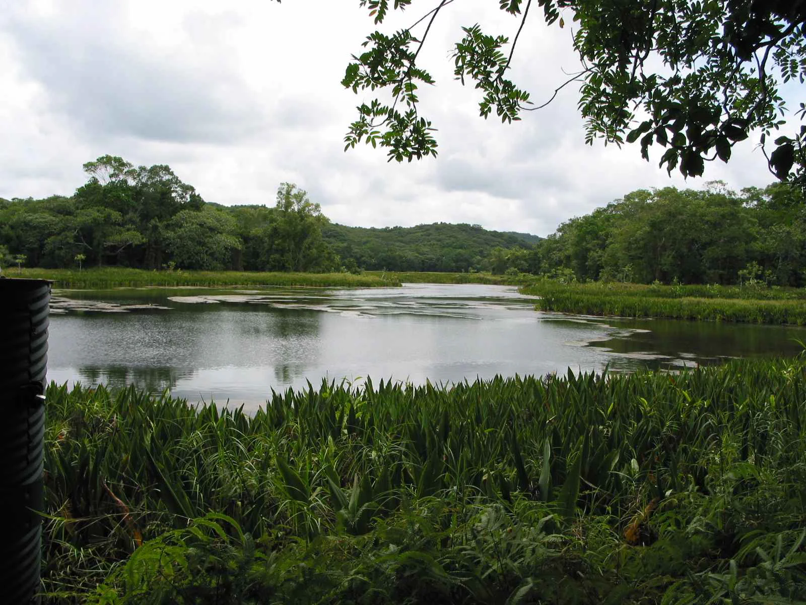
A peaceful lake surrounded by lush green tropical forest under a cloudy sky.
A scenic view across the calm waters of Lake Ngardok on the island of Babeldaob, Palau.

Lake Ngardok history and protected-area timeline

Lake Ngardok has long been recognized as a special place in the traditional landscape of Babeldaob, valued for its fresh water, wildlife, and ecosystem services that sustain surrounding communities. Its modern conservation history began with the formal establishment of the Ngardok Nature Reserve by the Chief Council of Melekeok State, an effort driven by concerns that slow watershed degradation was compromising the quality of the lake's water.

In 2002, the lake and its associated wetlands received international recognition when they were designated as Ramsar Wetland of International Importance, designated in October of that year. The Ramsar listing drew wider attention to the site's value as crocodile habitat, endemic bird habitat, and a representative example of Palau's tropical freshwater ecosystems. Alongside this international designation, the Melekeok leadership has continued to manage the reserve as a buffer against forest loss, sedimentation, and other threats to the watershed.

The lake has also entered a new chapter in Palau's national planning, as discussions have considered developing it as a freshwater reservoir to supply Ngerulmud, the country's capital, which is located within Melekeok State. This has raised questions about how best to balance the growing freshwater needs of the capital with the conservation commitments that first brought the lake international recognition.

Lake Ngardok landscape and geographic character

Lake Ngardok occupies a broad low-lying basin on Babeldaob, framed by the rolling forested terrain that characterizes much of Palau's largest island. The lake itself is a relatively shallow freshwater body ringed by marshlands, with open water near the center transitioning to vegetation-choked margins where land and water intermingle.

Drainage from the catchment converges on the lake and exits via the Ngerdorch River, a short watercourse that links the inland basin to the coast. The surrounding landscape is dense tropical forest, with the terrain shaped by heavy rainfall, stream erosion, and gradual sediment deposition around the lake margins. From the air, the site appears as a roughly oval blue and green lens set within the broader green carpet of Babeldaob's interior.

Lake Ngardok ecosystems, habitats, and plant life

The ecological character of Lake Ngardok is defined by the close interaction between freshwater, marshland, and tropical forest within a single compact watershed. Nutrient-rich waters and the calm, sheltered margins of the lake support rich plant communities that in turn shelter a wide variety of animal life. The forest that surrounds and feeds the lake is central to the system, regulating water flow, filtering sediment, and maintaining the chemical balance that keeps the lake habitable for its more sensitive species.

Wetland vegetation along the margins and the open water of the lake together create a layering of habitats that is rare in Palau and across much of Micronesia. This habitat diversity has allowed a community of endemic and island-restricted species to persist here, especially birds, while also supporting the much rarer freshwater-dependent population of saltwater crocodiles. The combination of lowland wetland, gallery forest, and intact upland forest makes the lake basin a near-complete representation of Babeldaob's freshwater ecology.

Lake Ngardok wildlife and species highlights

Wildlife is the defining feature of Lake Ngardok and the primary reason the site has drawn international conservation attention. The lake and its marshes constitute one of the most important refuges for the endangered saltwater crocodile in Palau, providing both habitat for resident animals and a breeding ground for the species. The Ngerdorch River plays a special role here, acting as the route along which crocodiles move between the lake and the sea.

The surrounding forests and wetlands support a distinctive bird community, much of it endemic to Palau. The Palau fruit dove, known locally as biib, the Palau fantail (melimdelebdeb), the Micronesian imperial pigeon (belochel), common moorhens and Pacific black ducks (both called debar), and the Palau flycatcher (charmelachull) are all associated with the lake basin. A local fruit bat, referred to as olik, also inhabits the area. Together, these species give the lake region a uniquely Palauan character of bird and mammal life that depends on the integrity of the surrounding forests.

Lake Ngardok conservation status and protection priorities

Lake Ngardok stands out as one of the most important freshwater conservation sites in Micronesia. It holds population-level significance for the endangered saltwater crocodile at a regional scale, and its forests and wetlands harbor endemic avifauna that occur nowhere else on Earth. The combination of threatened species, intact habitat, and a clearly defined watershed gives the site a layered conservation value that has been recognized both locally and internationally.

Protection of the lake has been driven significantly by the traditional authorities of Melekeok State, with the Chief Council establishing the Ngardok Nature Reserve to slow the degradation of the watershed that feeds the lake. The recognition that the health of the surrounding forest directly determines the quality of the lake's water has shaped the reserve's management philosophy, treating the catchment as an inseparable part of the protected area. The site's designation as a Ramsar Wetland of International Importance in 2002 gave formal global standing to these local efforts and created a long-term conservation framework around the lake.

Lake Ngardok cultural meaning and human context

Lake Ngardok is embedded in the traditional landscape and stewardship systems of the Palauan people, particularly within the State of Melekeok where it lies. In Palau's customary governance, chiefs and community councils play a leading role in land and resource management, and the lake has historically been valued both as a freshwater resource and as a culturally significant natural feature of Babeldaob.

The Melekeok Chief Council's role in establishing and maintaining the Ngardok Nature Reserve reflects this broader tradition of local stewardship, where conservation decisions are tied to cultural identity, traditional leadership, and the long-term interests of the community. The lake's local names for many of its birds and bats, such as biib for the Palau fruit dove and olik for native fruit bats, also point to a deep familiarity with the wildlife that depends on the lake, passed down through generations of Palauan knowledge.

Top sights and standout views in Lake Ngardok

Lake Ngardok combines three of the rarest qualities in Pacific conservation: a large natural freshwater lake, an inland refuge for the endangered saltwater crocodile, and a forest catchment that still supports multiple endemic bird species. The lake's role as a crocodile breeding site, linked to the sea by the Ngerdorch River, makes it a rare example of an intact saltwater crocodile ecosystem anchored in a tropical watershed.

At the same time, the site's international recognition as a Ramsar Wetland, its traditional protection by the Melekeok leadership, and its importance for endemic Palauan birds together make it a flagship site for freshwater and wetland conservation in Micronesia. Whether viewed as a natural landmark, a wildlife refuge, or a cultural resource, Lake Ngardok offers a portrait of how Pacific island ecosystems link land, water, wildlife, and people within a single basin.

Best time to visit Lake Ngardok

As a tropical freshwater ecosystem within Palau's wet tropical climate, Lake Ngardok experiences consistently warm temperatures and high humidity year-round, with rainfall shaping the character of any potential visit. The dry season, generally associated with lower rainfall and more stable conditions, tends to offer calmer views across the lake's surface and better access to surrounding forest trails, while the wetter months bring higher water levels and more visibly active wetland margins.

Wildlife viewing opportunities shift subtly with the seasons: crocodile activity and bird presence remain a feature throughout the year, while water levels and vegetation density along the marshes change in response to rainfall. The most rewarding general conditions for a nature-focused visit typically align with periods of moderate water levels, when both wetland habitats and forest edges remain accessible and wildlife visibility is good.
Monthly climate preview

Long term temperature and precipitation records measured at representative park coordinates

Lake Ngardok Climate Normals and Annual Weather Patterns

Lake Ngardok maintains consistent baseline temperatures alongside measured monthly precipitation variations across the representative coordinate. Reviewing the complete twelve month profile clarifies the underlying climatological rhythm in greater detail.
Annual mean28 °C
28 °C28 °C
Jan28°
Feb28°
Mar28°
Apr28°
May28°
Jun28°
Jul28°
Aug28°
Sep28°
Oct28°
Nov28°
Dec28°
Warmest month
May

28.3 °C

Coolest month
February

27.5 °C

Wettest month
July

11.9 mm/day

Driest month
March

5.7 mm/day

Park location guide

Geography guide, regional context, and park location map for Lake Ngardok

Lake Ngardok park geography, regions, and map view in Palau

Understand where Lake Ngardok sits in Palau through a broader geographic reading of the surrounding landscape, nearby location context, and its mapped position within the national park landscape.

How Lake Ngardok fits into Palau

Palau is a sovereign island nation located in the western Pacific Ocean within the Micronesia subregion of Oceania. The country consists of roughly 340 islands forming part of the Caroline Islands chain. It achieved full independence in 1994 through a Compact of Free Association with the United States, having previously been under Spanish, German, Japanese, and US administration.

Wider geography shaping Lake Ngardok in Palau

Palau is located in the western Pacific Ocean as part of the Caroline Islands in the Micronesia region of Oceania. The archipelago sits near Indonesia to the south, the Philippines to the northwest, and the Federated States of Micronesia to the east. The largest island is Babeldaob, where the capital Ngerulmud is located in Melekeok State.

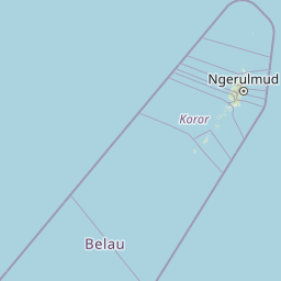
Map view of Lake Ngardok

Use this park location map to pinpoint Lake Ngardok in Palau, understand its exact geographic position, and read its mapped placement within the surrounding landscape more clearly.

Pigeon | © OpenStreetMap contributors

Location context for Lake Ngardok

Melekeok

Visual exploration of wetland habitats and tropical forest terrain in Palau

Lake Ngardok Photos and Protected Landscape Scenery

Visual documentation of Lake Ngardok reveals the distinctive freshwater wetlands and forested catchment that define this protected reserve. Examining these landscape views provides clear insight into the remote terrain and ecological character of the Babeldaob basin.

A peaceful lake surrounded by lush green tropical forest under a cloudy sky.

Park atlas

Compare surrounding regional geography and connected wetland habitats across Palau.

Exploring Parks Near Lake Ngardok and Related Protected Landscapes in the Region

Browse other protected areas and regional conservation zones situated across the surrounding landscape. Comparing adjacent park geography provides a broader perspective on island ecosystems beyond Lake Ngardok.
Nature reserveState of Ngeremlengui
About 15 km away#1 closest

West

Bkulabeluu Conservation Area: Inland Forest Nature Reserve in Ngeremlengui, Palau

Mapped protected landscapes of northern Babeldaob

Deepen your understanding of Bkulabeluu Conservation Area, a significant nature reserve situated in the interior highlands of the State of Ngeremlengui. This atlas entry details the volcanic ridges, tropical rainforest vegetation, and watershed connectivity that define the protected landscape of Babeldaob island, serving as a cornerstone for terrestrial conservation in Palau.

Marine protected areaNgaraard
About 15 km away#2 closest

North

East Coast Ngaraad Marine Conservation Area: Marine Protected Area and Coastal Map

Northern Babeldaob coastal geography and marine reserve boundaries

Located in Ngaraard State, this marine protected area serves as a significant site for reef conservation and coastal habitat preservation in Palau. The region illustrates the connection between tropical island forest watersheds and reef-fringed lagoons, providing a clear view of the protected coastal environment in northern Babeldaob.

Relief
Lowland
Climate
Tropical
Access
Access unknown
Scope
Marine
Nature reserveState of Airai
About 20 km away#3 closest

South

Airai State Conservation Area: Protected Forest and Watershed Geography in the State of Airai

Nature reserve on Babeldaob Island, Palau

Located in the State of Airai on Babeldaob Island, this nature reserve protects native forest and watershed headwaters. The area is a key example of state-level terrestrial conservation in Palau, providing essential inland habitat and contributing to the island's overall ecological health through its managed landscape boundaries.

Relief
Lowland
Protected areaPalau
About 30 km away#4 closest

North

Ebiil Channel Conservation Area: Geographic Map and Protected Marine Landscape Profile

Coastal conservation mapping in northern Palau

Examine the physical geography and protected maritime boundaries of the Ebiil Channel Conservation Area. This site highlights the coastal transition zones between land and sea in northern Palau, providing essential context for the reef-based topography and marine reserves of the archipelago.

Water
Water-dominated
A watercolor painting showing a panoramic view of green islands surrounded by calm, light blue water under a soft pink and yellow sunrise or sunset sky.
Marine protected areaKoror
About 46 km away#5 closest

Southwest

Rock Islands: Protected Marine Landscape and Limestone Archipelago Mapping

Geographic analysis of the reef-derived island system in Koror, Palau.

The Rock Islands consist of hundreds of limestone outcrops scattered across the Southern Lagoon, forming a mosaic of vegetated caps and narrow intertidal notches. This atlas entry provides a structured look at the archipelago's protected boundaries, marine lagoon features, and the unique geology that distinguishes these island landforms in the western Pacific.

Area
41.12 km²
Established
2012
Relief
Lowland
Climate
Tropical
Marine protected areaYap
About 444 km away#6 closest

Northeast

Nimpal Channel Marine Conservation Area: Geography and Protected Marine Landscapes in Yap

Community-managed coastal reefs and tidal mangrove systems

Located in Yap, the Nimpal Channel Marine Conservation Area functions as a protective node for local reef ecosystems. This 77-hectare reserve serves as a model for community-based stewardship, linking the health of mangrove-fringed shorelines with the resilience of the surrounding tidal channel habitats in the western Pacific.

Area
0.77 km²
Relief
Lowland
Climate
Tropical
Access
Access unknown
Marine protected areaDavao Oriental
About 926 km away#7 closest

West

Pujada Bay Protected Seascape: Marine Protected Area and Coastal Landscape in Davao Oriental

Coastal geography and protected marine ecosystems of Mindanao

Pujada Bay Protected Seascape serves as a primary coastal sanctuary along the Davao Oriental shoreline. Defined by the convergence of mountain-fed rivers, mangrove forests, and coral reef habitats within a semi-enclosed bay, this protected area offers a deep look into the marine geography of the Philippine archipelago.

Area
212 km²
Established
1994
Relief
Mixed relief
Access
Access unknown
Wildlife reserveAgusan del Sur
About 967 km away#8 closest

West

Agusan Marsh Wildlife Sanctuary: Mapping a Vast Freshwater Protected Area

Swamp forests and river basin geography in Agusan del Sur

Agusan Marsh Wildlife Sanctuary represents a crucial freshwater wetland complex within the Agusan River basin. The area is defined by its expansive swamp forests and semi-permanent floating lakes, which serve as essential migratory transit points and support an intricate network of aquatic ecosystems across the Mindanao region.

Area
148.36 km²
Established
1996
IUCN
IV
Relief
Lowland

Common questions about visiting, size, designation, and location context for Lake Ngardok

Lake Ngardok FAQs for park facts, access, geography, and protected area context

Find quick answers about Lake Ngardok, including protected-area facts, park geography, trail and visitor context, and how the park fits into its surrounding country and regional landscape.
MoriAtlas Explorer

Continue Your Protected Areas Search Across the Global Atlas

Deepen your exploration by continuing the structured search for national parks and protected areas worldwide. Utilize the comprehensive filtering capabilities to compare different conservation landscapes and refine your understanding of global park geography. Discover more about the distribution and characteristics of protected natural areas.

Global natural geography

