
Mori Atlas logo
National parkLake Pujŏn National Park

Discover the mapped boundaries and regional context of this protected natural area in South Hamgyong Province.

Lake Pujŏn National Park: National Park Geographic Atlas and Protected Landscape Exploration

Lake Pujŏn National Park represents a significant protected natural area within South Hamgyong Province, North Korea. As a designated national park, its detailed geographic boundaries and landscape context are critical for atlas-based exploration. This resource provides a structured view of Lake Pujŏn National Park, enabling users to understand its place within the regional geography and explore its protected land identity through detailed map-centric data.

mountain lakeconiferous forestimportant bird areagreat bustardprotected areaHamgyong Mountains

Lake Pujŏn National Park

National park

Park overview

Structured park overview, official facts, and landscape profile for Lake Pujŏn National Park

Lake Pujŏn National Park park facts, protected area profile, and essential visitor context

Review the core facts for Lake Pujŏn National Park, including designation, size, terrain, visitor scale, habitats, and operating context in one park-focused overview.

About Lake Pujŏn National Park

Lake Pujŏn National Park protects a mountainous lake ecosystem in the northern reaches of the Korean Peninsula. The park's central feature is Lake Puon, a freshwater body sitting at considerable altitude within the Hamgyong Mountains. Surrounding the lake and comprising the majority of the protected area is temperate coniferous forest, creating a landscape of ecological coherence between aquatic and terrestrial habitats. The park's elevation between 900 and 1190 meters places it within a montane climate zone distinct from the lowland environments that dominate much of the Korean landscape. This highland setting, combined with the lake and forest combination, makes the area ecologically significant within the regional context. The park also carries historical weight as the location of the Pujŏn Revolutionary Battle Site, connecting the natural landscape to significant events in Korean history.

Quick facts and research context for Lake Pujŏn National Park

Lake Pujŏn National Park occupies a mountain basin in the Hamgyong Mountains at roughly 900-1190 meters elevation. The protected area spans roughly 2600 hectares centered on Lake Puon, a freshwater lake surrounded by coniferous forest. The park has been identified by BirdLife International as an Important Bird Area due to its population of great bustards, a vulnerable species. The site also holds historical significance as the location of the Pujŏn Revolutionary Battle Site.

Protection and recognition

Mapping the conservation classification and official management scope of the protected landscape

Documented Protection Status and Legal Designation of Lake Pujŏn National Park

National park datasets provide critical details regarding the management frameworks and official conservation boundaries of Lake Pujŏn National Park. Scholars and geographers can analyze how regional protection zones align with global conservation databases to understand the formal status of the protected terrain.

Protection details

Protection scope
Mixed
Transboundary protection
No
Park context

Deeper park guide and search-rich context for Lake Pujŏn National Park

Lake Pujŏn National Park history, landscape, wildlife, and travel context

Explore Lake Pujŏn National Park through its history, landscape character, ecosystems, wildlife, conservation priorities, cultural context, and seasonal travel timing in a structured park guide built for atlas discovery and search intent.

Why Lake Pujŏn National Park stands out

Lake Pujŏn National Park is best known for its population of great bustards, a large ground bird classified as vulnerable by the International Union for Conservation of Nature. The park's recognition as an Important Bird Area by BirdLife International stems from this significant breeding and栖息 population. The combination of a high-altitude freshwater lake with adjacent coniferous forest creates a distinctive montane ecosystem that supports this notable bird species.

Lake Pujŏn National Park history and protected-area timeline

The historical significance of Lake Pujŏn National Park centers on the Pujŏn Revolutionary Battle Site located within its boundaries. This location marks events from the revolutionary period of Korean history, though detailed historical documentation available in English sources is limited. The area's transformation into a protected national park reflects later efforts to preserve both the natural environment and sites of historical importance. The formal designation as a national park elevated the area's protection status, though precise details of the establishment timeline are not extensively documented in available sources.

Lake Pujŏn National Park landscape and geographic character

The landscape of Lake Pujŏn National Park is characterized by a mountainous terrain within the Hamgyong Mountains, a range running along the eastern side of the Korean Peninsula. The terrain rises to elevations between 900 and 1190 meters, placing the park in a subalpine to montane elevation zone. Lake Puon sits as the scenic centerpiece, a freshwater lake whose still waters reflect the surrounding forested slopes. The adjacent coniferous forest covers the hillsides surrounding the lake, creating a typically dense evergreen landscape. This combination of water and forest against a mountain backdrop defines the park's visual character.

Lake Pujŏn National Park ecosystems, habitats, and plant life

The nature of Lake Pujŏn National Park centers on the interplay between its freshwater lake ecosystem and surrounding temperate coniferous forest. The lake provides aquatic habitat supporting fish and other freshwater organisms, while the adjoining forest creates terrestrial habitats for woodland species. The montane setting at nearly 1000 meters elevation means the area experiences cooler temperatures and distinct seasonal patterns compared to lower elevations. The coniferous forest likely includes species adapted to colder mountain conditions, creating an ecosystem typical of northern Korean highland environments.

Lake Pujŏn National Park wildlife and species highlights

The wildlife of Lake Pujŏn National Park gains particular recognition through its birdlife, most notably the great bustard. This large ground-dwelling bird, which can weigh up to 20 kilograms, breeds in the open grasslands and agricultural areas of temperate Eurasia. The park's identification as an Important Bird Area by BirdLife International confirms its significance as a habitat for this vulnerable species. The presence of great bustards indicates that the park's open areas and surrounding habitats provide suitable breeding and foraging grounds. Beyond birds, the freshwater lake supports aquatic species, while the forest harbors woodland wildlife typical of northern Korean mountain ecosystems.

Lake Pujŏn National Park conservation status and protection priorities

Lake Pujŏn National Park's conservation significance is underscored by its designation as an Important Bird Area by BirdLife International, a global partnership of conservation organizations focused on bird conservation. This recognition identifies the park as a site supporting significant bird populations, specifically the vulnerable great bustard. The IBA designation reflects international acknowledgment that the park's habitats are essential for biodiversity conservation. The protected area status provides a framework for maintaining the ecological integrity of the lake and forest ecosystem, though detailed management information is limited in available sources.

Lake Pujŏn National Park cultural meaning and human context

The cultural context of Lake Pujŏn National Park includes its designation as the location of the Pujŏn Revolutionary Battle Site, connecting the natural landscape to moments of historical significance in Korean history. This aspect elevates the park's value beyond purely ecological conservation to include cultural and historical preservation. The mountainous terrain of the Hamgyong Mountains has historically served as a backdrop for events shaping Korean history, and the park preserves a tangible link to this heritage. The dual nature of conservation, protecting both natural ecosystems and culturally significant sites, characterizes the park's broader protected area mission.

Top sights and standout views in Lake Pujŏn National Park

Lake Pujŏn National Park's highlights include its high-altitude freshwater lake set within the Hamgyong Mountains, surrounded by intact coniferous forest. The park's international recognition as an Important Bird Area for supporting vulnerable great bustard populations distinguishes it among Korea's protected areas. The combination of montane lake scenery, forest ecosystems, and historical battle site significance creates a multi-dimensional protected area. The elevation of 900-1190 meters places this park in a distinctive highland environment different from Korea's coastal and lowland parks.

Best time to visit Lake Pujŏn National Park

The best time to visit Lake Pujŏn National Park would likely align with the warmer summer months when conditions are most suitable for outdoor exploration of the mountain environment. The summer season would offer the most comfortable temperatures for hiking around the lake and through the forest, though specific visitor access information for this park in North Korea would require local guidance.

Monthly climate preview

Long-term representative point measurements tracking monthly temperature and precipitation variation

Lake Pujŏn National Park Climate Normals and Annual Temperature Rhythm

Lake Pujŏn National Park records tracked monthly temperature swings from deep sub-zero winter minimums to warm summer maximums alongside varying daily precipitation rates. Examining the full twelve-month profile provides detailed meteorological context derived from long-term representative coordinate data.
Annual mean2 °C
-15 °C17 °C
Jan-15°
Feb-12°
Mar-6°
Apr
May
Jun14°
Jul17°
Aug17°
Sep12°
Oct
Nov-4°
Dec-13°
Warmest month
July

17.5 °C

Coolest month
January

-15.1 °C

Wettest month
July

6 mm/day

Driest month
January

0.3 mm/day

Park location guide

Geography guide, regional context, and park location map for Lake Pujŏn National Park

Lake Pujŏn National Park park geography, regions, and map view in North Korea

Understand where Lake Pujŏn National Park sits in North Korea through a broader geographic reading of the surrounding landscape, nearby location context, and its mapped position within the national park landscape.

How Lake Pujŏn National Park fits into North Korea

North Korea is a totalitarian communist state on the Korean Peninsula in East Asia. It borders China and Russia to the north, South Korea to the south, and is bordered by the Yellow Sea to the west and Sea of Japan to the east. The country was established in 1948 following the division of Korea after World War II and is ruled by the Kim family under a hereditary dictatorship.

Wider geography shaping Lake Pujŏn National Park in North Korea

North Korea occupies the northern portion of the Korean Peninsula in East Asia. The country's northern border is formed by the Yalu (Amnok) River and Tumen River, which separate it from China and Russia. To the south, the Korean Demilitarized Zone marks the border with South Korea. The western coast borders the Yellow Sea while the eastern coast borders the Sea of Japan. The terrain is predominantly mountainous with the Baekdu Mountain range in the north.

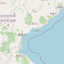
Map view of Lake Pujŏn National Park

Use this park location map to pinpoint Lake Pujŏn National Park in North Korea, understand its exact geographic position, and read its mapped placement within the surrounding landscape more clearly.

Pigeon | © OpenStreetMap contributors

Location context for Lake Pujŏn National Park

South Hamgyong Province
Park atlas

Trace the geography of surrounding protected areas and compare similar natural landscapes in the region.

Discover Other National Parks and Protected Areas Near Lake Pujŏn National Park

Users exploring Lake Pujŏn National Park can continue discovering a broader range of national parks and protected areas across its surrounding mountainous region. Compare diverse montane ecosystems, freshwater lake environments, and coniferous forest reserves to deepen your geographic understanding of protected landscapes.
National parkGangwon Province
About 278 km away#1 closest

South

Seoraksan National Park: A Protected Landscape Within Gangwon Province's Geography

Explore mapped boundaries and regional protected-area distribution.

Seoraksan National Park is a crucial protected area offering a unique lens into the natural landscapes of Gangwon Province. This national park serves as a key geographic anchor, detailed here with its mapped boundaries and regional context for comprehensive atlas exploration. Understand its role as a conservation landscape and discover its place within South Korea's protected lands.

Area
398.22 km²
Established
1970
IUCN
II
Relief
Mountain
National parkGangwon-do
About 310 km away#2 closest

South

Odaesan National Park: South Korea's Protected Landscape and Geographic Context in Gangwon-do

Explore the mapped boundaries and regional terrain of this national park.

Access detailed geographic information and atlas-style exploration for Odaesan National Park, a protected National Park located in Gangwon-do, South Korea. Understand its distinct landscape character and mapped boundaries, contributing to a broader understanding of protected areas within the regional geography. This resource is designed for users interested in the specific geographic identity and mapped context of individual park entities.

Area
303.93 km²
Established
1975
IUCN
II
Relief
Mountain
National parkGyeonggi Province
About 321 km away#3 closest

South

Bukhansan National Park: Protected Area Geography and Mapped Boundaries in Gyeonggi Province

Explore the landscape context of this national park.

Bukhansan National Park stands as a distinct protected area within Gyeonggi Province, offering a rich landscape for geographic exploration. This entry focuses on its identity as a national park, detailing its mapped boundaries and its contribution to the regional geography. Users can explore its protected landscape features and understand its significance through a structured, map-centric approach, enriching their atlas understanding of protected natural areas.

Area
79.92 km²
Established
1983
IUCN
II
Visitors
5M annual
Watercolor illustration of rolling green hills, scattered trees, and distant mountains under a pale sky.
National parkPrimorsky Krai
About 334 km away#4 closest

Northeast

Land of the Leopard National Park: Protected Area Map and Geographic Context in Primorsky Krai

Atlas exploration of Russia's critical Amur leopard habitat.

Investigate Land of the Leopard National Park, a nationally significant protected area situated in Primorsky Krai, Russia. This park is celebrated as the exclusive remaining sanctuary for the critically endangered Amur leopard, making it a focal point for global conservation efforts. Its varied landscape, characterized by forested slopes and mountainous terrain, serves as essential habitat not only for leopards but also for Siberian tigers. The park provides a rich geographic setting for understanding protected land distribution and regional ecosystems within the Russian Far East.

Area
2,799 km²
Established
2012
IUCN
II
Relief
Mixed relief
National parkGangwon-do
About 358 km away#5 closest

South

Chiaksan National Park: National Park Protected Landscape and Geographic Context in Gangwon-do

Explore mapped boundaries and regional terrain.

Chiaksan National Park is a designated national park within South Korea's Gangwon-do region, offering a focused entry point for geographic discovery. This resource details the park's protected landscape, its mapped boundaries, and its relation to the surrounding natural terrain. Delve into the atlas-style context of Chiaksan National Park to understand its significance as a protected natural area within its regional geography.

Area
181.57 km²
Established
1984
IUCN
II
Relief
Mountain
National parkHeilongjiang
About 381 km away#6 closest

Northeast

Northeast China Tiger and Leopard National Park: Protected Natural Landscape and Geographic Context

Explore Heilongjiang's national park and mapped terrain.

This entry provides a detailed atlas view of Northeast China Tiger and Leopard National Park, a designated national park located in Heilongjiang. Understand its protected landscape, geographic positioning, and the regional natural terrain it encompasses. The focus is on its mapped boundaries and contribution to the broader protected-area geography, offering a factual basis for understanding its landscape context within China.

Area
14,612 km²
Established
2021
Relief
Mountain
Climate
Temperate
National parkChungcheongbuk-do
About 405 km away#7 closest

South

Sobaeksan National Park: A Protected Landscape within Chungcheongbuk-do

Explore its park boundaries and regional geography.

Sobaeksan National Park represents a crucial protected area within the mountainous terrain of Chungcheongbuk-do, South Korea. As a designated national park, it offers a valuable point of reference for understanding regional geographic distribution and landscape context across the Korean Peninsula. This park's identity as a protected natural landscape contributes significantly to the atlas-based exploration of conservation areas and their environmental settings.

Area
322.38 km²
Established
1987
IUCN
II
Relief
Mountain
National parkSouth Korea
About 414 km away#8 closest

South

Taean Seaside National Park: National Park Geography and Mapped Landscape Discovery

South Korea's protected coastal terrain.

Explore the precise geographic identity of Taean Seaside National Park, a key protected area within South Korea. This page offers an atlas-style perspective on its landscape context, mapped boundaries, and regional distribution across the Korean Peninsula. Understand its role as a national park and its contribution to the mapped natural terrain of East Asia.

Area
840 km²
Established
1978
IUCN
II
Relief
Lowland

Common questions about visiting, size, designation, and location context for Lake Pujŏn National Park

Lake Pujŏn National Park FAQs for park facts, access, geography, and protected area context

Find quick answers about Lake Pujŏn National Park, including protected-area facts, park geography, trail and visitor context, and how the park fits into its surrounding country and regional landscape.
MoriAtlas Explorer

Continue Your Protected Areas Search Across the Global Atlas

Deepen your exploration by continuing the structured search for national parks and protected areas worldwide. Utilize the comprehensive filtering capabilities to compare different conservation landscapes and refine your understanding of global park geography. Discover more about the distribution and characteristics of protected natural areas.

Global natural geography