
Mori Atlas logo
Nature reserveLeimersheimer Altrhein

Examining the ecological geography and floodplain boundaries of this vital Rhine oxbow habitat

Leimersheimer Altrhein Nature Reserve: A Detailed Map and Protected Landscape Overview

(Vogelschutzgebiet Karlskopf und Leimersheimer Altrhein)

Leimersheimer Altrhein serves as a critical protected landscape within the Upper Rhine floodplain of Rhineland-Palatinate. This nature reserve, formed by a historic river meander, remains a vital refuge for waterbirds and provides a rare, intact example of riparian wetland architecture. Our detailed geographic mapping highlights the core oxbow features, the Karlskopf peninsula, and the surrounding connectivity within the broader Natura 2000 wetland network.

Upper Rhine floodplainRhine oxbowAltrheinbird protection areaVogelschutzgebietNatura 2000
A flat vector illustration of a river scene with a waterfall flowing over cliffs into a calm body of water, framed by stylized trees and foliage.

Leimersheimer Altrhein

Nature reserve

Park overview

Structured park overview, official facts, and landscape profile for Leimersheimer Altrhein

Leimersheimer Altrhein park facts, protected area profile, and essential visitor context

Review the core facts for Leimersheimer Altrhein, including designation, size, terrain, visitor scale, habitats, and operating context in one park-focused overview.

About Leimersheimer Altrhein

Leimersheimer Altrhein is a compact but ecologically rich protected area that reflects both the engineering history of the Upper Rhine and the resilience of its floodplain ecosystems. The site lies within the active floodplain of the Rhine near the community of Leimersheim, south of Speyer, and takes its identity from an old channel that was abandoned when the river was straightened in the 19th century. Over time this severed arm evolved into a semi-natural water body encircling a wooded peninsula known as the Karlskopf, creating a quiet, largely inaccessible refuge in an otherwise intensively used agricultural landscape.

The protected area was formally designated in 2004 as an EU Bird Protection Area, or Vogelschutzgebiet, under the name Karlskopf und Leimersheimer Altrhein. It belongs to the Natura 2000 network and is recognized under IUCN Category IV as a Habitat/Species Management Area. Although it covers only about 15 hectares, its functional role stretches well beyond its boundaries because it is embedded within overlapping protective designations. It complements the larger Vogelschutzgebiet Hördter Rheinaue, lies within the Hördter Rheinaue nature reserve and the matching FFH site, and contributes to the broader landscape protection area of the Pfälzische Rheinauen.

The site's profile has been shaped by the broader transformation of the Upper Rhine. Over the course of the 19th and 20th centuries, the river was regulated, dyked, shortened, and separated from much of its former floodplain, eliminating large areas of natural wetland habitat. In this heavily engineered setting, surviving old river arms like the Leimersheimer Altrhein have become disproportionately important for biodiversity, particularly for species that depend on open water, quiet shorelines, and minimal human disturbance. The mosaic of open water, gravel lake remnants, riparian forest, and the largely untouched Karlskopf peninsula creates a habitat combination that now ranks among the most valuable waterbird sites in Rhineland-Palatinate.

Quick facts and research context for Leimersheimer Altrhein

The Leimersheimer Altrhein is a 15-hectare bird protection area located in the Germersheim district of Rhineland-Palatinate, Germany, just south of Speyer. It was established in 2004 as part of the EU Birds Directive network and carries the WDPA identifier 555537847 and the Natura 2000 code DE6816403. The site is classified under IUCN Category IV as a Habitat/Species Management Area and lies within the continental biogeographical region of the Upper Rhine Plain.

Its core feature is an old Rhine arm surrounding the largely inaccessible Karlskopf peninsula, created during 19th-century river straightening. The protected area is integrated into a broader conservation landscape that includes the Hördter Rheinaue nature reserve, the matching FFH site, and the Pfälzische Rheinauen landscape protection area.

Protection and recognition

Structured conservation records and international recognition framework for Leimersheimer Altrhein.

Leimersheimer Altrhein Protection Status and Official Designation Data

Conservation metrics for Leimersheimer Altrhein compile official protected area records and administrative designation data. Verified database identifiers map the precise protection scope and international recognition context associated with the landscape.

Protection details

WDPA ID
555537847
Park context

Deeper park guide and search-rich context for Leimersheimer Altrhein

Leimersheimer Altrhein history, landscape, wildlife, and travel context

Explore Leimersheimer Altrhein through its history, landscape character, ecosystems, wildlife, conservation priorities, cultural context, and seasonal travel timing in a structured park guide built for atlas discovery and search intent.

Why Leimersheimer Altrhein stands out

Leimersheimer Altrhein is best known for its exceptional importance to waterbirds within an otherwise heavily modified river landscape. The oxbow shelters the only major inland cormorant breeding colony in Rhineland-Palatinate and supports winter concentrations of ducks, especially teal, that are unmatched elsewhere in the state. Equally important is what the site represents as a landscape: a rare surviving example of an Upper Rhine floodplain mosaic where open water, undisturbed islands, and riparian vegetation still coexist. In a region where channelization and regulation have eliminated most natural river dynamics, the Leimersheimer Altrhein demonstrates the ecological value of the old floodplain channels that were left behind when the Rhine was forced into a straightened course.
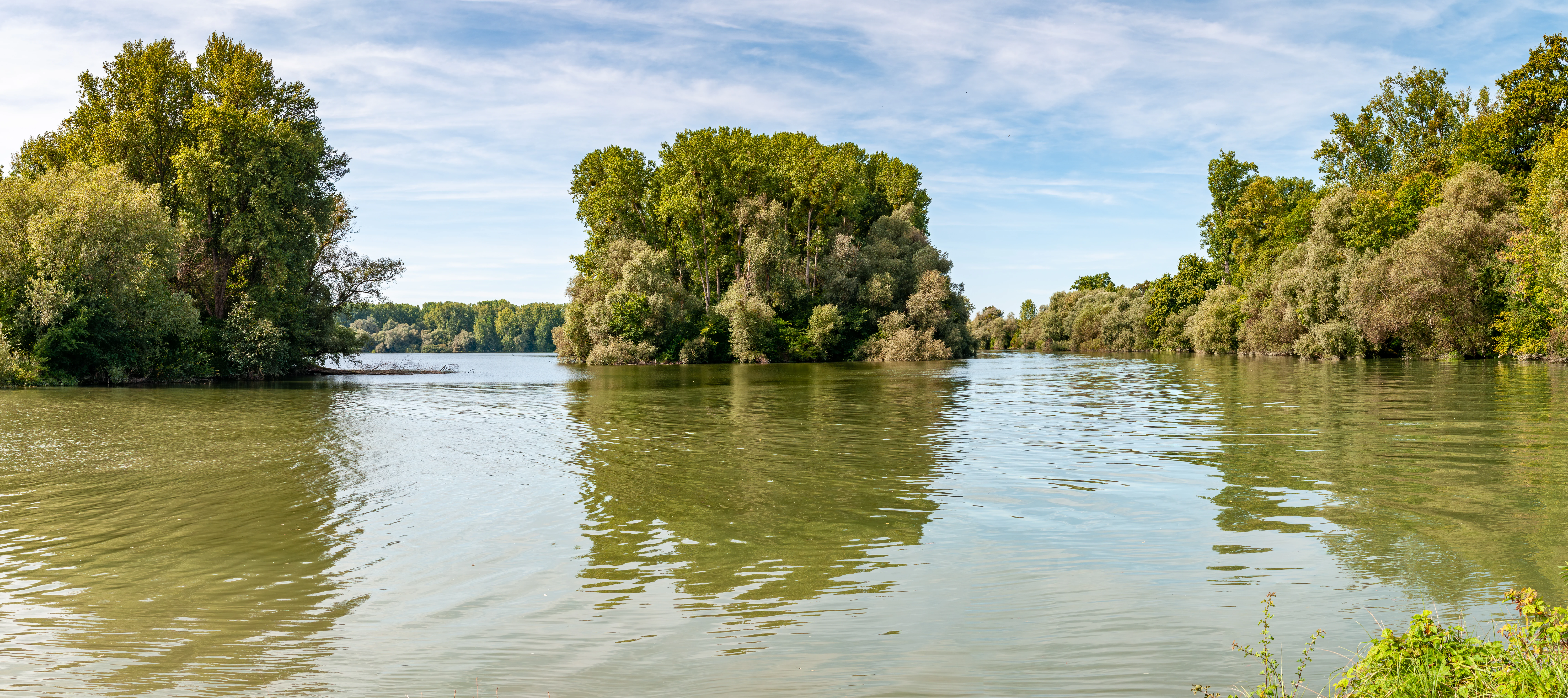
A wide-angle landscape shot of a calm, greenish-grey river surrounded by dense green trees on small islands and banks under a light blue, partly cloudy sky.
A panoramic view of the Leimersheimer Altrhein floodplain and its forested islands.

Leimersheimer Altrhein history and protected-area timeline

The Leimersheimer Altrhein is fundamentally a historical artifact of the large-scale engineering of the Upper Rhine during the 19th century. The straightening and shortening of the Rhine under Johann Gottfried Tulla's rectification program cut the river off from many of its meanders, leaving behind a network of old channels, called Altrheine, that persist today as semi-natural water bodies. The arm near Leimersheim became one of these surviving relics, gradually evolving from a stagnant oxbow into a richly structured floodplain landscape with riparian forest, gravel banks, and undisturbed interior zones.

Recognition of the site's ecological value came much later. In 2004, the area was formally designated as a Vogelschutzgebiet under the European Union Birds Directive, with the official name Karlskopf und Leimersheimer Altrhein. The designation placed the old river arm within the Natura 2000 network and tied it to the neighboring Hördter Rheinaue conservation complex. It was simultaneously integrated into the existing landscape protection area of the Pfälzische Rheinauen, ensuring coordinated protection across multiple administrative frameworks. Since then the site has continued to function primarily as a refuge for waterbirds and as a rare example of an intact Upper Rhine floodplain habitat.

Leimersheimer Altrhein landscape and geographic character

The landscape of Leimersheimer Altrhein is defined by a quiet, enclosed water world set within the active floodplain of the Upper Rhine. A former meander of the Rhine curves around the Karlskopf, a wooded and largely inaccessible peninsula that forms the visual and ecological heart of the site. The combination of still water, forested banks, and sheltered interior zones gives the area an unusually tranquil atmosphere compared to the intensively cultivated surroundings of the Rhine Plain.

At the site level, the protected area includes the old river arm itself along with a former gravel extraction lake adjacent to the Karlskopf. Where the Altrhein rejoins the active Rhine, the transition is marked by a wide, open-mouthed confluence that contrasts with the narrower, more enclosed sections further upstream. The surrounding land belongs to the broader Pfälzische Rheinauen, where floodplain forests, meadows, and secondary channels continue the landscape character beyond the strict borders of the bird protection area. Overall, the site reads as a small but unusually intact fragment of the historical Rhine floodplain ecosystem.

Leimersheimer Altrhein ecosystems, habitats, and plant life

Ecologically, Leimersheimer Altrhein is best understood as a floodplain mosaic shaped by the interplay of open water, undisturbed islands, and riparian woodland. The still waters of the old Rhine arm support aquatic vegetation along their banks, while the Karlskopf peninsula provides extensive forested cover and a near-shore environment that is rarely disturbed by human activity because access is restricted.

The protected area is explicitly classified as a Habitat/Species Management Area under IUCN Category IV, reflecting its primary role in maintaining habitats for specific species groups rather than conserving a broad wilderness. It lies within the continental biogeographical region and contributes to the diminishing network of near-natural aquatic and wetland habitats in the Upper Rhine Plain. By retaining a flowing connection to the active Rhine and preserving undisturbed gravel lake shorelines, the site helps offset some of the ecological losses caused by centuries of river regulation and floodplain conversion elsewhere in the region.

Leimersheimer Altrhein wildlife and species highlights

Wildlife at Leimersheimer Altrhein is dominated by birds, in line with the site's formal status as an EU Bird Protection Area. The mature, inaccessible character of the Karlskopf peninsula has allowed a large cormorant breeding colony to establish itself here, and the colony is now the most significant of its kind in Rhineland-Palatinate.

In winter, the oxbow attracts substantial concentrations of waterfowl. Mixed flocks of dabbling and diving ducks use the sheltered waters, with teal in particular assembling here in numbers that are not matched elsewhere in the state. The combination of open water, gravel lake remnants, quiet forested banks, and minimal disturbance makes the site attractive to a wide range of waterbirds and gives it an importance for avian conservation that extends well beyond its small footprint.

Leimersheimer Altrhein conservation status and protection priorities

The conservation significance of Leimersheimer Altrhein lies chiefly in what it preserves of an ecological type that has almost vanished from the Upper Rhine. By retaining a near-natural old river arm with undisturbed shorelines and a wooded central island, the site safeguards habitat conditions that have been lost across most of the surrounding floodplain through river straightening, dyke construction, gravel extraction, and agricultural conversion.

Formally, the area is protected through a layered system of designations. As a Vogelschutzgebiet it contributes to the European Union's Natura 2000 network, with explicit objectives of maintaining or restoring a flowing old Rhine arm and disturbance-free gravel lakes with natural shorelines. At national and regional level it is covered by the Hördter Rheinaue nature reserve, the matching FFH site, and the larger landscape protection area of the Pfälzische Rheinauen, creating a coordinated framework of protection. The site is also integrated into regional conservation efforts by organizations such as NABU Südpfalz and BUND Rheinland-Pfalz, reinforcing its role as a local stronghold for waterbird conservation.

Leimersheimer Altrhein cultural meaning and human context

The cultural context of Leimersheimer Altrhein is closely bound up with the history of Upper Rhine regulation. The nineteenth-century straightening of the Rhine under Johann Gottfried Tulla transformed the region's hydrology, leaving a complex of old river arms whose cultural memory is now inseparable from their ecological role. The Leimersheimer arm, named after the nearby community of Leimersheim, is one of these surviving traces and has become a local point of reference for the historical relationship between the Rhine and its floodplain.

There is no developed indigenous or community cultural narrative attached to the site in the source material, and the area's identity today is shaped much more by conservation institutions and regional environmental groups than by long-standing settlement traditions. As a result the cultural dimension is best appreciated as part of the broader heritage of the Pfälzische Rheinauen rather than as a stand-alone cultural story.

Top sights and standout views in Leimersheimer Altrhein

Standout qualities of Leimersheimer Altrhein include the unusual combination of an old Rhine arm, a quiet forested peninsula, and a former gravel lake, all preserved within a relatively small footprint. These features together support habitats that have been largely wiped out elsewhere in the Upper Rhine Plain, making the site a compact but disproportionately valuable refuge.

For visitors and researchers, the key draws are its role as the most important inland cormorant breeding site in Rhineland-Palatinate, its exceptionally large winter gatherings of waterfowl, and its representation of a vanishing type of floodplain landscape. The integration of the site into the larger Hördter Rheinaue and Pfälzische Rheinauen conservation complex adds to its broader significance.

Best time to visit Leimersheimer Altrhein

The character of Leimersheimer Altrhein shifts markedly between the seasons, reflecting the ecology of an Upper Rhine oxbow. Spring and summer bring active breeding, including the visible presence of the cormorant colony on the Karlskopf and the activity of numerous waterbirds along the sheltered shorelines. These seasons typically offer the richest birdlife, though access around the protected zones is restricted to avoid disturbance.

Winter transforms the site into a refuge for waterfowl, when large flocks of ducks and other waterbirds gather on the unfrozen stretches of the old river arm and the gravel lake. For those interested in bird observation, this is often the most rewarding period, though visitors should expect cooler conditions and should treat the surrounding floodplain landscape as sensitive habitat at any time of year.


Monthly climate preview

Measured long term temperature progression and monthly precipitation averages

Leimersheimer Altrhein Climate Normals and Annual Weather by Month

Representative point records for Leimersheimer Altrhein outline a measured annual temperature range from sub zero winter minimums to warm summer maximums alongside steady monthly precipitation. Exploring the complete twelve month profile provides granular baseline statistics for long term climatological research across this protected landscape.
Annual mean10 °C
1 °C21 °C
Jan
Feb
Mar
Apr10°
May15°
Jun19°
Jul21°
Aug20°
Sep16°
Oct10°
Nov
Dec
Warmest month
July

20.9 °C

Coolest month
January

0.6 °C

Wettest month
May

2.3 mm/day

Driest month
April

1.5 mm/day

Park location guide

Geography guide, regional context, and park location map for Leimersheimer Altrhein

Leimersheimer Altrhein park geography, regions, and map view in Germany

Understand where Leimersheimer Altrhein sits in Germany through a broader geographic reading of the surrounding landscape, nearby location context, and its mapped position within the national park landscape.

How Leimersheimer Altrhein fits into Germany

Germany is a federal republic in Western and Central Europe with a population of over 83 million across sixteen constituent states. It is Europe's largest economy by nominal GDP and a major global exporter and importer. The capital is Berlin, and the country borders Denmark, Poland, Czech Republic, Austria, Switzerland, France, Luxembourg, Belgium, and the Netherlands.

Wider geography shaping Leimersheimer Altrhein in Germany

Germany is located in Western and Central Europe, spanning 357,022 km². It borders Denmark to the north, Poland and the Czech Republic to the east, Austria and Switzerland to the south, and France, Luxembourg, Belgium, and the Netherlands to the west. The country has coastlines on the Baltic Sea and North Sea to the north, with the Alps located in the southern region.

Map view of Leimersheimer Altrhein

Use this park location map to pinpoint Leimersheimer Altrhein in Germany, understand its exact geographic position, and read its mapped placement within the surrounding landscape more clearly.

Pigeon | © OpenStreetMap contributors

Location context for Leimersheimer Altrhein

Rhineland-Palatinate

Visual reference guide for Upper Rhine floodplain habitats and oxbow terrain

Leimersheimer Altrhein Landscape Scenery and Protected Area Photos

Visual documentation captures the oxbow channels, forested peninsula, and wetland environments that define Leimersheimer Altrhein. Examining these protected area landscapes reveals the ecological structure of the Upper Rhine floodplain mosaic.

A wide-angle landscape shot of a calm, greenish-grey river surrounded by dense green trees on small islands and banks under a light blue, partly cloudy sky.

A peaceful, reflective lake surrounded by a dense forest under a clear sky, viewed from beneath overhanging tree branches.

Park atlas

Compare adjacent wetland habitats and river floodplain reserves across the region.

Parks Near Leimersheimer Altrhein, Exploring Regional Protected Landscapes

Browse protected areas surrounding Leimersheimer Altrhein to examine connected wetland corridors and river floodplain habitats. Continuing the geographic comparison reveals broader ecological patterns across the regional protected landscape network.
Watercolor painting of a tranquil wetland landscape with soft green vegetation and a calm water body, reflecting the floodplain environment of the Rhine river.
Nature reserveLandkreis Germersheim
Mapped location lies within the park boundary#1 closest

North

Hördter Rheinaue Nature Reserve: Landscape and Geographic Context in Landkreis Germersheim

Examining the hydrology and floodplain forest of the German Rhine.

Hördter Rheinaue serves as a critical node in the Palatinate Rhine floodplains, preserving a vast mosaic of willow and poplar forests alongside stable hardwood stands. Analyze the mapped terrain shaped by centuries of river activity, including the meandering Michelsbach and associated oxbow systems that define this essential protected corridor in western Germany.

Area
8.18 km²
Established
1966
IUCN
IV
Relief
Lowland
A soft, light watercolor painting of a wetland scene with a winding river branch, reeds, and low-lying greenery under a hazy sky.
Nature reserveRheinland-Pfalz
About 3 km away#2 closest

Southwest

Neupotzer Altrhein Nature Reserve: A Detailed Map and Geographic Overview

Protected floodplain landscape in the Rheinland-Pfalz region.

The Neupotzer Altrhein reserve stands as a prominent example of Rhine floodplain recovery, featuring a diverse topography of slow-moving water channels, marshes, and softwood alluvial forests. Located in the Rheinland-Pfalz district of Germersheim, this protected area offers significant insight into the historical and natural shifts of the Rhine corridor, serving as a key refuge within the European Natura 2000 network.

Area
2.375 km²
Established
2000
IUCN
IV
Relief
Lowland
A watercolor painting showing a soft, atmospheric landscape with a foreground of water and green grasses, a midground of trees, and purple mountains in the background under a pale yellow sky.
Nature reserveRhineland-Palatinate
About 7.1 km away#3 closest

Southwest

Rheinniederung Neuburg-Wörth: A Protected Floodplain Landscape in Rhineland-Palatinate

An analysis of river meanders, oxbows, and floodplain forest geography

This nature reserve encompasses a 14.5 square kilometer corridor of the Upper Rhine, featuring a distinct topography of hardwood forests, wet meadows, and aquatic habitats. The site remains a focal point for understanding Rhine river dynamics and the conservation of rare floodplain ecosystems like the Wörther Altrhein.

Area
14.48 km²
Established
2004
Relief
Lowland
Climate
Temperate
Nature reserveRheinland-Pfalz
About 7.6 km away#4 closest

Southwest

Wörther Altrhein Nature Reserve: Protected Wetland Atlas and Upper Rhine Landscape Context

Mapped conservation zones within the Rheinland-Pfalz floodplain

Investigate the protected landscape of Wörther Altrhein, an ecologically important former Rhine channel. This site offers a unique study in wetland geography, where controlled hydrology supports diverse reedbeds and alluvial forest habitats within the industrial backdrop of the southern Upper Rhine.

Area
2.4 km²
Established
2004
IUCN
IV
Relief
Lowland
Nature reserveRhineland-Palatinate
About 9.7 km away#5 closest

Northwest

Bellheimer Wald: Protected Alluvial Forest and Inland Dune Geography in Germany

Nature reserve landscapes in Rhineland-Palatinate

Bellheimer Wald offers a window into the unique geography of the Upper Rhine Plain. This protected forest is characterized by its sandy alluvial soils and rare inland dune systems, forming a core component of the alluvial-fan woodland chain that spans the southern Palatinate and supports complex habitats for specialized flora and fauna.

Area
46.79 km²
Established
2000
IUCN
IV
Relief
Lowland
A horizontal watercolor painting depicting a soft-focus landscape with a central tree, calm water, and rolling hills in the background.
Nature reserveRhineland-Palatinate
About 10 km away#6 closest

North

Brückenkopf Nature Reserve: An Atlas of Protected Floodplain Geography in Rhineland-Palatinate

Detailed mapping of rare wetland habitats and regional floodplain zones

Brückenkopf offers a unique look at small-scale habitat conservation in the Germersheim district. This nature reserve protects a vital fragment of the Upper Rhine floodplain, serving as a sanctuary for specific wetland flora and rare invertebrates. Gain a better understanding of its location between major infrastructure corridors and the river, marking it as a significant component of regional conservation strategy.

Area
0.357 km²
Established
1982
IUCN
IV
Relief
Lowland
A watercolor landscape illustration showing a gently winding water feature through low-lying marshy vegetation with distant rolling hills.
Protected landscapeBaden-Württemberg
About 13 km away#7 closest

Southeast

Füllbruch-Vokkenau Protected Landscape: Geographic Profile and Regional Map Context

Wetland mosaic and flood-retention geography in Baden-Württemberg

This protected landscape in Karlsruhe encompasses a distinct lowland floodplain forest, merging traditional orchard meadows with structured wet woodland terrain. The area is defined by its role in regional flood management for the Pfinz river, creating a unique intersection of protected natural habitat and active hydraulic infrastructure within the historical Kinzig-Murg lowland channel.

Area
4.313 km²
Established
1988
IUCN
V
Protected landscapeBaden-Württemberg
About 13 km away#8 closest

Southeast

Weingartener Wiesental Protected Landscape: Geography and Meadow Valley Overview

Historic irrigation heritage in the Baden-Württemberg region.

The Weingartener Wiesental provides a clear example of a managed meadow valley landscape, featuring an extensive network of historical irrigation ditches and a surviving aqueduct. Situated within the Hardtebenen natural region, this protected area serves as an ecological buffer and a window into the traditional land management practices characteristic of the Kinzig-Murg-Rinne river corridor.

Area
1.109 km²
Established
1991
IUCN
V
Relief
Lowland

Common questions about visiting, size, designation, and location context for Leimersheimer Altrhein

Leimersheimer Altrhein FAQs for park facts, access, geography, and protected area context

Find quick answers about Leimersheimer Altrhein, including protected-area facts, park geography, trail and visitor context, and how the park fits into its surrounding country and regional landscape.
MoriAtlas Explorer

Continue Your Protected Areas Search Across the Global Atlas

Deepen your exploration by continuing the structured search for national parks and protected areas worldwide. Utilize the comprehensive filtering capabilities to compare different conservation landscapes and refine your understanding of global park geography. Discover more about the distribution and characteristics of protected natural areas.

Global natural geography