

Mori Atlas logo
Nature reserveLengenberg

Analyzing the limestone ridge geography and rare yew forest ecosystems in central Europe

Lengenberg Nature Reserve and the Protected Forest Landscapes of Thuringia, Germany

Lengenberg Nature Reserve sits as a significant north-south ridge within the Eichsfeld region of Thuringia, Germany. This protected area preserves one of the largest yew populations in central Europe under a dominant beech canopy. The terrain transitions from higher shell limestone formations to lower red sandstone, creating a complex geological environment that defines the forest character across the Eichsfeld-Hainich-Werratal landscape.

nature reserveyew forestbeech forestMuschelkalkThuringiaEichsfeld

Lengenberg

Nature reserve

Park overview

Structured park overview, official facts, and landscape profile for Lengenberg Nature Reserve

Lengenberg Nature Reserve park facts, protected area profile, and essential visitor context

Review the core facts for Lengenberg Nature Reserve, including designation, size, terrain, visitor scale, habitats, and operating context in one park-focused overview.

About Lengenberg Nature Reserve

The Lengenberg Nature Reserve lies in the heart of the Upper Eichsfeld, a gently rolling limestone plateau in the western part of Thuringia. The reserve covers a forested ridge that runs roughly north to south, bounded by the River Leine to the north and by its left-bank tributaries, the Lutter to the east and the Griesbach to the west. The terrain rises from the Lichtenbühl in the north to approximately 485 meters near Fürstenhagen in the south, where it merges smoothly into the broader Eichsfeld plateau and the Eichstruther Kopf.

Geologically, the Lengenberg is built on Muschelkalk, or shell limestone, which forms the elevated plateaus and ridges of the Upper Eichsfeld; only the northern flanks, including the smaller Kleiner Lichtenbühl, transition into the older Buntsandstein red sandstone formations of the Lower Eichsfeld. This underlying structure supports a woodland-dominated environment where beech forests dominate the canopy, and where the western slopes host the protected yew-rich forest stands that give the reserve its identity.

The protected area, designated in 1961, occupies roughly 26 hectares on the western slopes of the ridge. Its ecological value rests on the presence of one of central Europe's largest yew populations, an unusual and ecologically significant feature given the decline of mature yew forests across much of the continent. The Lengenberg sits within the larger Eichsfeld-Hainich-Werratal Nature Park, and the southern forest edge near Fürstenhagen hosts the nature park's visitor center, which serves as a starting point for the Eibenwald nature trail. This trail leads visitors along the Forsthaus Lengenberg and through the reserve's signature yew stands, connecting conservation protection with accessible interpretation.

Quick facts and research context for Lengenberg Nature Reserve

The Lengenberg is a roughly north-south oriented spur of the Upper Eichsfeld Muschelkalk plateau, situated in the western Landkreis Eichsfeld around four kilometers southwest of Heilbad Heiligenstadt in Thuringia. Its highest named point, the Lichtenbühl, rises to approximately 461.6 meters above sea level, while the ridge reaches about 485 meters near Fürstenhagen before blending into the surrounding plateau.

The 26-hectare nature reserve, first designated in 1961, lies within the larger Eichsfeld-Hainich-Werratal Nature Park and protects one of central Europe's most significant stands of European yew (Taxus baccata) supported within a largely beech-dominated forest. The reserve forms part of a network of protected areas across the Eichsfeld district and serves as both a conservation site and an accessible destination via the Eibenwald interpretive trail.

Protection and recognition

Comprehensive records on terrestrial boundaries and governance framework

Lengenberg Protection Status and Official Protected Area Designation Facts

Examine the official protection status and management scope established for Lengenberg within its terrestrial conservation landscape. Review documented designation records to understand the administrative framework governing this protected area.

Protection details

Protection scope
Terrestrial
Transboundary protection
No
Park context

Deeper park guide and search-rich context for Lengenberg Nature Reserve

Lengenberg Nature Reserve history, landscape, wildlife, and travel context

Explore Lengenberg Nature Reserve through its history, landscape character, ecosystems, wildlife, conservation priorities, cultural context, and seasonal travel timing in a structured park guide built for atlas discovery and search intent.

Why Lengenberg Nature Reserve stands out

The Lengenberg Nature Reserve is best known for housing one of the largest yew (Eibe) populations in central Europe, set within an old-growth beech forest environment. The reserve's significance lies in the unusual density and age of its yew stands, an ecological feature that is increasingly rare across the broader central European landscape. Its identity is also shaped by its setting on a Muschelkalk ridge capped with beech woodland, by the dramatic views from the nearby Maienwand looking across to the Lichtenbühl peaks, and by its role as an educational destination. The Naturlehrpfad Eibenwald trail and the adjacent nature park visitor center make the Lengenberg a focal point for understanding native forest ecology within the Eichsfeld-Hainich-Werratal Nature Park.
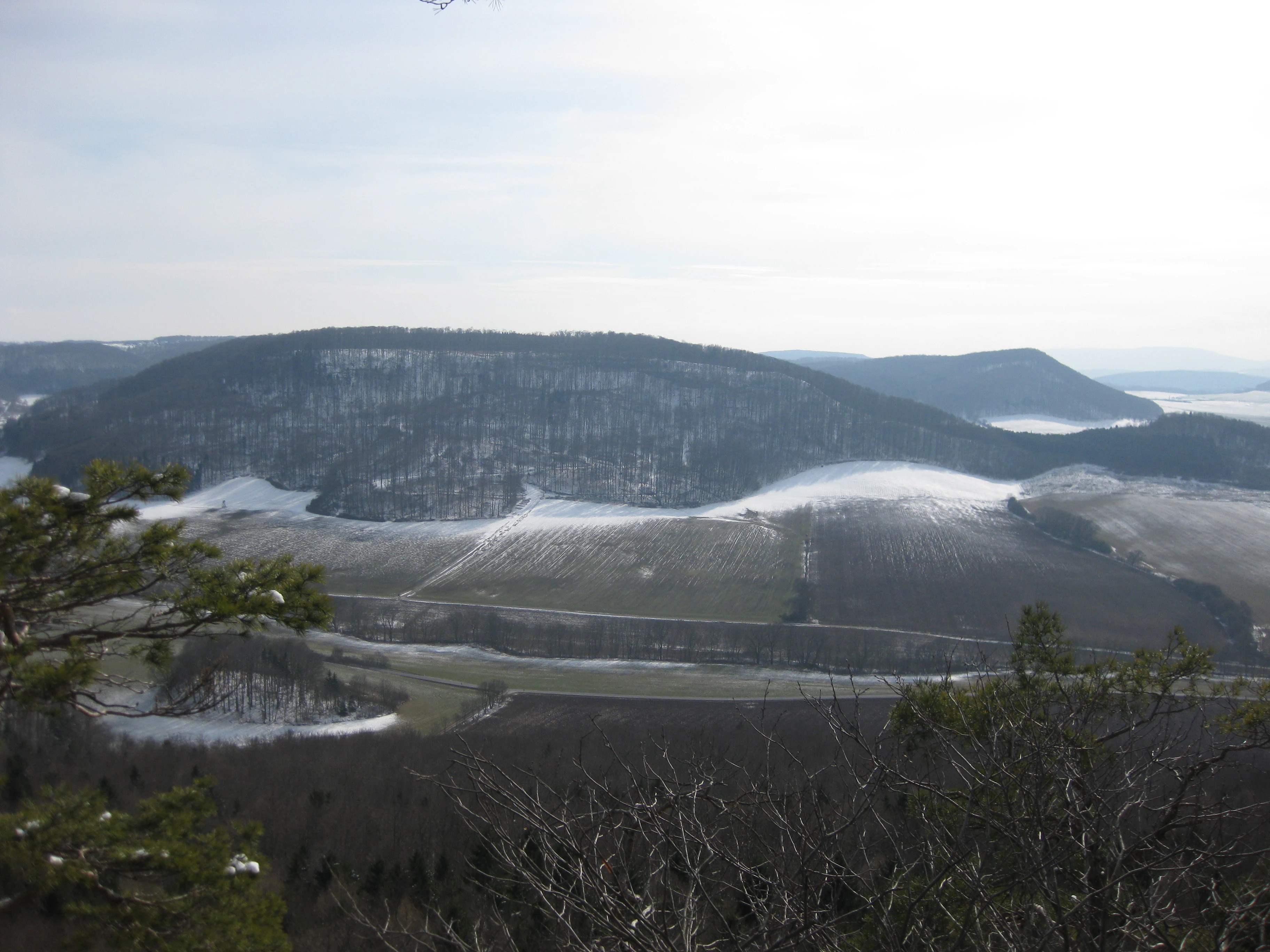
View of Lengenberg
View from Maienwand looking toward Lengenberg, featuring Großer Lichtenbühl on the left, Kleiner Lichtenbühl on the right, Knappberg in the center, and Hoher Meißner in the right background.

Lengenberg Nature Reserve history and protected-area timeline

The Lengenberg was formally designated as a nature reserve (Naturschutzgebiet) in 1961, acknowledging both the ancient character of its forest cover and the exceptional significance of its yew population. By the time of its designation, the beech and yew forests of the ridge had already been recognized as a regionally and nationally valuable ecological site.

The reserve's later history has been closely tied to the development of the Eichsfeld-Hainich-Werratal Nature Park, which now encompasses the wider landscape around the Lengenberg. The establishment of a nature park visitor center at the southern forest edge near Fürstenhagen marked a turning point in public engagement with the area, providing an interpretive gateway for the Eibenwald nature trail.

Scientific attention to the forest communities of the Lengenberg has also shaped its modern profile. A 1992 diploma thesis documented the deciduous woodland associations of the Lengenberg southwest of Heiligenstadt, contributing to the broader botanical understanding of the Eichsfeld landscape.

Lengenberg Nature Reserve landscape and geographic character

The Lengenberg is a wooded, north-south running ridge that forms a western spur of the Upper Eichsfeld Muschelkalk plateau. From its northernmost peak, the Lichtenbühl at approximately 461.6 meters, the ridge extends about two kilometers to the south-southwest, rising slightly to roughly 485 meters near Fürstenhagen before merging with the broader plateau and the Eichstruther Kopf to the southwest.

The terrain is shaped by contrast between the higher Muschelkalk formations of the Eichsfeld and the lower Buntsandstein zone of the Lower Eichsfeld to the northwest. The Kleiner Lichtenbühl, at about 375.6 meters, sits in this sandstone transition zone, providing a geological counterpoint to the main ridge. The western flanks of the Lengenberg drop toward the Griesbach valley, while the eastern side faces the Lutter valley and the settlements of Lutter and Fürstenhagen.

The ridge is wholly forested, giving it a uniformly dark canopy when viewed from neighboring vantage points such as the Maienwand. This continuous woodland cover, combined with the underlying limestone geology and the radial pattern of surrounding watercourses, defines the visual character of the Lengenberg landscape.

Lengenberg Nature Reserve ecosystems, habitats, and plant life

The Lengenberg's forest ecosystem is one of the defining natural features of the Upper Eichsfeld. The ridge is completely forested, with beech as the dominant tree species across most of the canopy, reflecting the typical woodland character of the region's Muschelkalk slopes. Old-growth beech stands provide both the structural complexity and the stable microclimate that allow more sensitive species to persist within the forest understory.

The most ecologically distinctive element of the Lengenberg is its population of European yew (Taxus baccata). On the western slopes, within the core of the 26-hectare nature reserve, mature yews grow alongside the beech canopy, forming one of the most substantial yew populations in central Europe. This combination of shade-tolerant yew with beech is uncommon at such density and represents a key conservation priority for the protected area.

The transitional geology between Muschelkalk and Buntsandstein further enriches the ecological gradients along the northern flanks of the ridge. Where sandstone appears, in the area of the Kleiner Lichtenbühl, conditions differ from the limestone-dominated central ridge, producing subtle variations in soil chemistry and plant community composition. These transitions support the diverse woodland associations documented in regional botanical studies of the Lengenberg.

Lengenberg Nature Reserve wildlife and species highlights

While the Lengenberg is primarily recognized for its forest vegetation rather than its larger mammal fauna, the reserve's old-growth character provides important habitat continuity for woodland wildlife. The dense canopy, well-developed understory, and minimal disturbance create conditions suitable for typical central European forest species, including birds and small mammals that depend on mature deciduous forest for nesting and foraging.

The ecological value of the reserve is closely tied to the longevity and structural diversity of its trees. Yews and old beeches offer cavities, dense foliage cover, and stable microhabitats that support invertebrates, fungi, and the woodland bird communities typical of ancient deciduous forest. The continuity of the forest cover across the whole ridge also strengthens the area's role as a refuge and stepping stone within the broader forest mosaic of the Eichsfeld-Hainich-Werratal Nature Park.

The reserve's significance lies less in charismatic megafauna and more in the integrity of its woodland habitat. This integrity underpins the survival of less conspicuous but ecologically important species that depend on the particular combination of beech and yew that defines the Lengenberg's forest environment.

Lengenberg Nature Reserve conservation status and protection priorities

The Lengenberg was first designated as a nature reserve in 1961, making it one of the older formally protected forest sites in the Eichsfeld district. Its protection recognizes the exceptional botanical value of the site, particularly the occurrence of one of central Europe's largest European yew populations amid a largely beech-dominated forest.

The reserve covers about 26 hectares on the western slopes of the ridge and is embedded within the larger Eichsfeld-Hainich-Werratal Nature Park, which extends protective and landscape-level management across the surrounding region. This dual designation, both as a strict nature reserve and as part of a broader landscape-level nature park, supports a layered conservation approach combining strict habitat protection with public education and sustainable regional land use.

Conservation of the Lengenberg is also closely connected to public interpretation. The Naturlehrpfad Eibenwald trail and the adjacent nature park visitor center provide structured access that minimizes impact on the most sensitive yew stands while raising awareness of their ecological significance. Together, these elements position the Lengenberg as a key reference site for yew forest conservation in central Europe.

Lengenberg Nature Reserve cultural meaning and human context

The Lengenberg lies within a region, the Eichsfeld, that carries a long history of small-scale rural settlement, forestry, and ecclesiastical cultural traditions typical of the borderland between Thuringia and Lower Saxony. Villages such as Lutter, Fürstenhagen, Lenterode, and Wüstheuterode cluster around the ridge, shaping a centuries-long relationship between local communities and the surrounding forested hills.

Forestry is a visible thread in the cultural landscape, reflected in features such as the historic Forsthaus Lengenberg, which lies along the modern Eibenwald nature trail. The naming of sub-peaks like the Großer Lichtenbühl and Kleiner Lichtenbühl, folk-derived toponyms that survive in local usage, hints at the long familiarity of residents with the topography of the ridge.

The broader Eichsfeld identity, marked by Catholic heritage within an otherwise predominantly Protestant region of Germany, adds a regional cultural layer to the landscape. While the Lengenberg is primarily valued as a natural site, its setting within this distinctive cultural region informs how the area is interpreted and experienced by visitors.

Top sights and standout views in Lengenberg Nature Reserve

The Lengenberg Nature Reserve's standout feature is its yew forest, one of the largest and most ecologically significant Taxus baccata populations in central Europe, growing under a beech canopy on shell limestone soils. The reserve's full forest cover, its position on a clearly defined north-south ridge, and the transition between Muschelkalk and Buntsandstein geology add further layers of distinction.

Equally notable is the integration of conservation and public access: the Eibenwald nature trail, the Forsthaus Lengenberg, and the Eichsfeld-Hainich-Werratal Nature Park visitor center at Fürstenhagen combine to make the reserve a focal point for forest-based recreation and environmental education within the Eichsfeld.

Best time to visit Lengenberg Nature Reserve

The Lengenberg is best experienced during the warmer months, when the beech and yew forest is fully leafed out and the interpretive trail through the Eibenwald is most accessible. Late spring and early summer bring rich green foliage to the canopy and active birdlife in the surrounding woodland, while autumn features the warm colors of the deciduous forest contrasted against the dark, evergreen character of the yew stands.

Because the entire ridge is forested, views from within the reserve are limited, but nearby vantage points such as the Maienwand offer broader panoramas toward the Lichtenbühl under clear conditions. Visitors seeking quiet forest walks, interpretive engagement, and a sense of old-growth woodland are well served across the spring, summer, and autumn seasons; winter visits are possible but should account for potentially limited trail conditions in this rural upland setting.

Monthly climate preview

Monthly temperature averages and precipitation records for Lengenberg

Lengenberg Climate Normals, Long-Term Temperature and Precipitation Patterns

Representative coordinate measurements reveal the long-term annual temperature and precipitation rhythm across Lengenberg from 1991 through 2020. Examining the complete twelve-month climate profile provides deeper statistical context regarding monthly temperature fluctuations and precipitation totals.
Annual mean8 °C
-1 °C18 °C
Jan-1°
Feb
Mar
Apr
May12°
Jun16°
Jul18°
Aug18°
Sep14°
Oct
Nov
Dec
Warmest month
July

18.2 °C

Coolest month
January

-0.9 °C

Wettest month
July

2.6 mm/day

Driest month
April

1.5 mm/day

Park location guide

Geography guide, regional context, and park location map for Lengenberg Nature Reserve

Lengenberg Nature Reserve park geography, regions, and map view in Germany

Understand where Lengenberg Nature Reserve sits in Germany through a broader geographic reading of the surrounding landscape, nearby location context, and its mapped position within the national park landscape.

How Lengenberg Nature Reserve fits into Germany

Germany is a federal republic in Western and Central Europe with a population of over 83 million across sixteen constituent states. It is Europe's largest economy by nominal GDP and a major global exporter and importer. The capital is Berlin, and the country borders Denmark, Poland, Czech Republic, Austria, Switzerland, France, Luxembourg, Belgium, and the Netherlands.

Wider geography shaping Lengenberg Nature Reserve in Germany

Germany is located in Western and Central Europe, spanning 357,022 km². It borders Denmark to the north, Poland and the Czech Republic to the east, Austria and Switzerland to the south, and France, Luxembourg, Belgium, and the Netherlands to the west. The country has coastlines on the Baltic Sea and North Sea to the north, with the Alps located in the southern region.

Map view of Lengenberg Nature Reserve

Use this park location map to pinpoint Lengenberg Nature Reserve in Germany, understand its exact geographic position, and read its mapped placement within the surrounding landscape more clearly.

Pigeon | © OpenStreetMap contributors

Location context for Lengenberg Nature Reserve

Thuringia

Explore detailed imagery of the ancient yew forest, beech canopy, and limestone terrain.

Lengenberg Photos and Landscape Scenery: Visualizing the Protected Forest Ridge

Visual records capture the dense forest canopy, distinct limestone ridge formations, and rare yew populations defining the natural environment of Lengenberg. Examining these protected habitats provides clear visual insight into the topography and ecological character of the Eichsfeld region.

View of Lengenberg

Park atlas

Compare adjacent forest reserves and regional protected areas across Thuringia

Explore Other Parks Near Lengenberg and Surrounding Protected Landscapes

Browsing other parks near Lengenberg reveals connected forest ecosystems and regional geological formations across the surrounding Eichsfeld territory. Comparing these neighboring protected landscapes provides a broader geographic perspective on central European woodland conservation.
Nature reserveThuringia
About 4.5 km away#1 closest

Southwest

Röhrsberg - Hasenwinkel - Mühlberg: Mapping the Protected Landscapes of Thuringia

Geological ridge systems and native forest habitat networks.

The Röhrsberg - Hasenwinkel - Mühlberg nature reserve represents a significant protected area in Thuringia, characterized by the juxtaposition of Muschelkalk limestone hills and Zechstein dolomite ridges. This site offers a concentrated view of regional terrain, shifting from closed beech forests to open juniper heaths. It serves as an essential geographic reference for understanding the ecological mosaic of the lower Werra hill country.

Area
4.51 km²
Established
1999
IUCN
IV
Relief
Upland
Nature reserveThuringia
About 5.3 km away#2 closest

South

Stein, Rachelsberg, Gobert: A Protected Limestone Landscape in Western Thuringia

Mapping a historic nature reserve and beech forest complex

Stein, Rachelsberg, Gobert stands as a key protected area within Thuringia. This nature reserve offers deep insights into limestone ridge geography, historic border woodland continuity, and diverse habitats ranging from dry grasslands to tufa springs and orchid-rich beech forests.

Area
7.16 km²
Established
1999
IUCN
IV
Relief
Mountain
Nature reserveThuringia
About 5.9 km away#3 closest

Southwest

Stein, Rachelsberg Nature Reserve: Mapped Muschelkalk Terrain in Thuringia

Protected low mountain hills and forested karst landscapes

The Stein, Rachelsberg nature reserve in Thuringia represents a protected mosaic of Muschelkalk ridges and Buntsandstein valleys. Its geography is defined by strongly broken relief, rocky outcrops, and a unique ring of forested summits including the Dieberg and Goburg, forming an essential link in regional conservation networks across the Thuringia and Hesse border.

Area
5.06 km²
Established
2023
Relief
Mountain
Climate
Temperate
Nature reserveLandkreis Eichsfeld
About 7 km away#4 closest

West

Hasenwinkel bei Fretterode: Protected Dolomite Ridge and Juniper Heath in Landkreis Eichsfeld

Nature reserve geography and landscape analysis

The Hasenwinkel bei Fretterode nature reserve is characterized by a prominent dolomite ridge rising above the agricultural lands of Landkreis Eichsfeld. This site offers an look at historically grazed calcareous grasslands and rocky outcrops. Our mapping covers its extent as a vital component of the regional protected-area network, showcasing its ecological importance and distinctive geology.

Area
0.062 km²
Established
1939
IUCN
IV
Relief
Upland
Nature reserveThuringia
About 7.7 km away#5 closest

Southeast

Ibenkuppe Nature Reserve and the Muschelkalk Cuesta Landscapes of Thuringia

Mapped protected woodland and limestone escarpment geography

Located in the Eichsfeld district, Ibenkuppe is a nature reserve that protects a significant Muschelkalk spur. Its geography includes the prominent Abrißwand landslide scar and the deeply cut Rosoppe valley. This site provides a focused look at the intersection of forested limestone slopes and traditional valley pasture fragments in the heart of Germany.

Area
0.292 km²
Established
1997
Relief
Mountain
Scope
Terrestrial
Nature reserveWerra-Meißner-Kreis
About 8.1 km away#6 closest

South

Kalkklippen südlich des Iberges Nature Reserve and Muschelkalk Landscape Atlas

Protected beech forests and active landslide topography

This nature reserve in Werra-Meißner-Kreis reveals an active Muschelkalk ridge characterized by steep limestone cliffs and boulder-strewn talus slopes. Study the site's unique ecological composition, featuring noble hardwood-rich beech forests and native European yew populations that highlight the region's complex natural history and geological significance.

Area
0.473 km²
Established
1995
IUCN
IV
Nature reserveLandkreis Eichsfeld
About 9.9 km away#7 closest

West

Kelle, Teufelskanzel Nature Reserve: Geographic Overview and Protected Area Atlas

Steep slopes and sandstone ridges in Landkreis Eichsfeld

Situated along the Höheberg ridge in Thuringia, Kelle, Teufelskanzel represents a vital 200 hectare nature reserve. Its geography is defined by deep V-shaped valleys, dramatic rock outcrops like the Teufelskanzel, and a dense mix of deciduous forests that form part of the historic Inner German Border conservation zone.

Area
2.002 km²
Established
1996
IUCN
IV
Relief
Mountain
Nature reserveWerra-Meißner-Kreis
About 12 km away#8 closest

West

Ebenhöhe-Liebenberg Nature Reserve: Geography and Protected Habitat Mapping

Protected calcareous forests and dry grassland mosaic

Explore the mapped boundaries and natural terrain of the Ebenhöhe-Liebenberg nature reserve. This site provides a critical habitat mosaic including orchid-rich beech woodlands, nutrient-poor grasslands, and sandstone outcrops that form a significant conservation area within the Hessian highlands.

Area
142.48 km²
Established
1995
IUCN
IV
Relief
Upland

Common questions about visiting, size, designation, and location context for Lengenberg Nature Reserve

Lengenberg Nature Reserve FAQs for park facts, access, geography, and protected area context

Find quick answers about Lengenberg Nature Reserve, including protected-area facts, park geography, trail and visitor context, and how the park fits into its surrounding country and regional landscape.
MoriAtlas Explorer

Continue Your Protected Areas Search Across the Global Atlas

Deepen your exploration by continuing the structured search for national parks and protected areas worldwide. Utilize the comprehensive filtering capabilities to compare different conservation landscapes and refine your understanding of global park geography. Discover more about the distribution and characteristics of protected natural areas.

Global natural geography