Mori Atlas logo
Wildlife reserveReserva de producción de fauna Manglares El Salado

Mapping the tidal channels and estuarine terrain of this protected wildlife reserve in Guayas.

Reserva de producción de fauna Manglares El Salado: Protected Coastal Mangrove Ecosystems

(Reserva de Producción de Fauna Manglares El Salado)

Reserva de producción de fauna Manglares El Salado represents a critical protected coastal environment in the Guayas province of Ecuador. The area features a complex mosaic of mangrove fringe forest, salty flats, and patches of tropical dry forest shaped by an intricate network of tidal channels. By connecting to the Gulf of Guayaquil estuary through the Mongón, Plano Seco, and Salado estuaries, the reserve serves as a vital anchor for regional coastal biodiversity.

mangrovesestuarycoastal ecosystemtropical dry foresttidal channelssalt flats

Reserva de producción de fauna Manglares El Salado

Wildlife reserve

Park overview

Structured park overview, official facts, and landscape profile for Reserva de producción de fauna Manglares El Salado

Reserva de producción de fauna Manglares El Salado park facts, protected area profile, and essential visitor context

Review the core facts for Reserva de producción de fauna Manglares El Salado, including designation, size, terrain, visitor scale, habitats, and operating context in one park-focused overview.

About Reserva de producción de fauna Manglares El Salado

Manglares El Salado is a mangrove-focused fauna production reserve along Ecuador's southwestern Pacific coast, anchoring a stretch of mangrove forest associated with the Gulf of Guayaquil estuary. As part of the national system of protected areas administered by Ecuador's Ministry of Environment and Water, the reserve is designed to safeguard mangrove ecosystems while also accommodating uses consistent with its UICN Category VI protected-area status.

The protected landscape is structured around mangrove fringe forest, the dominant vegetation type, alongside patches of tropical dry forest and open salty flats that reflect repeated tidal influences. Three tidal estuaries, Mongón, Plano Seco, and Salado, shape the hydrology of the reserve and connect its mangrove channels to the broader estuarine system of the Gulf of Guayaquil. The Puerto Hondo mangroves are also included within the reserve's scope.

The reserve is positioned between Guayaquil, Ecuador's largest coastal city, and the Salinas road corridor that links to the Pacific beach resort zone. This proximity places Manglares El Salado at the intersection of conservation priorities, urban expansion, and coastal recreation. While the reserve continues to function as a productive mangrove ecosystem, its setting also raises ongoing conservation considerations related to surrounding urban growth, quarrying, and road infrastructure.

Quick facts and research context for Reserva de producción de fauna Manglares El Salado

Manglares El Salado is a national protected area in Ecuador administered under the SNAP, the country's national system of protected areas, and falls within the Guayas Province near Guayaquil. It carries a IUCN Category VI managed-resource protected-area designation. Created by official registry on 15 November 2002, with subsequent administrative modifications recorded in Ecuador's official register through 2017, the reserve was established to conserve mangrove and dry forest habitats around the Gulf of Guayaquil estuary.

The reserve encompasses mangrove forests, salty flats, remnants of tropical dry forest, and three tidal estuaries: Mongón, Plano Seco, and Salado. Coverage information varies slightly between original and later records, with figures in the low thousands of hectares cited around its full extent. Its proximity to both Guayaquil and the coastal road to Salinas makes it a relevant conservation area on Ecuador's southwestern Pacific coast.

Protection and recognition

Documented protection history and international recognition framework

Reserva de producción de fauna Manglares El Salado Protection Status and Management Scope

Reserva de producción de fauna Manglares El Salado maintains a mixed protection scope within its designated conservation boundaries. Documented records outline the administrative framework and official management criteria governing the protected area.

Protection details

Protection scope
Mixed
Transboundary protection
No
Park context

Deeper park guide and search-rich context for Reserva de producción de fauna Manglares El Salado

Reserva de producción de fauna Manglares El Salado history, landscape, wildlife, and travel context

Explore Reserva de producción de fauna Manglares El Salado through its history, landscape character, ecosystems, wildlife, conservation priorities, cultural context, and seasonal travel timing in a structured park guide built for atlas discovery and search intent.

Why Reserva de producción de fauna Manglares El Salado stands out

Manglares El Salado is best known for its mangrove-dominated coastal ecosystem, where mangrove fringe forest covers most of the protected surface and rises to notable heights along tidal channels. The reserve stands out as one of the protected mangrove complexes around the Gulf of Guayaquil that combines mangrove forest, salty flats, and tropical dry forest remnants in a single reserve area. Its ecological profile is reinforced by the presence of three named estuaries and by its wildlife richness, which includes crabs, river otters, native shrimps, catfish, and the Pacific coastal crocodile. The reserve's strong link between mangrove habitat and estuarine wildlife is what most clearly defines its identity within Ecuador's protected-area network.

Reserva de producción de fauna Manglares El Salado history and protected-area timeline

Manglares El Salado was formally established as a protected area through Ecuador's official registry on 15 November 2002, with the corresponding registration appearing in the official gazette in early January 2003. From its creation, the reserve was incorporated into the national system of protected areas under the administration of the SNAP and the country's environmental ministry.

Following its establishment, the reserve's administrative framework was adjusted through a series of ministerial agreements registered in Ecuador's official record between 2003 and 2017. These successive modifications reflect ongoing refinements to management and regulation rather than changes to the core identity of the protected area.

As a fauna production reserve, Manglares El Salado was conceived within a broader Ecuadorian strategy to protect mangrove belts around the Gulf of Guayaquil, a region historically important for estuarine biodiversity and for economically significant shellfish and shrimp species. The reserve's history is thus tied both to mangrove conservation and to the sustainable management of coastal-estuarine wildlife resources.

Reserva de producción de fauna Manglares El Salado landscape and geographic character

The landscape of Manglares El Salado is defined by a low-lying coastal plain shaped by tidal and estuarine processes. Mangrove fringe vegetation forms the dominant visual and ecological feature, with mangrove trees reaching notable heights and supported by their characteristic stilt roots within the intertidal zone.

Beyond the mangrove channels, the reserve also contains salty flats, locally known as salitrales, which reflect the arid and saline conditions typical of parts of the Ecuadorian coast. These flats alternate with limited remnants of tropical dry forest and small herbaceous formations, creating a mosaic of coastal-estuarine vegetation types rather than a single uniform mangrove cover.

Three named estuaries, Mongón, Plano Seco, and Salado, cut through the reserve and connect the mangrove system to the larger Gulf of Guayaquil estuary. The combination of mangrove channels, estuarine waters, salty flats, and dry forest patches gives the protected area a layered coastal landscape defined more by ecological transitions than by topographic relief.

Reserva de producción de fauna Manglares El Salado ecosystems, habitats, and plant life

Ecologically, Manglares El Salado is dominated by mangrove fringe forest, which according to records covers approximately three-quarters of the reserve's surface. This mangrove habitat forms the backbone of the area, while smaller formations of tropical dry forest, herbaceous cover, and salty flats contribute a diversity of microhabitats within a relatively compact coastal reserve.

The vegetation inventory describes around five mangrove species present in the reserve, some capable of reaching substantial heights, alongside roughly forty or more plant species linked to small dry forest patches and herbaceous communities, with additional species tied directly to mangrove or salty flat environments. The result is a habitat mosaic in which mangrove forest prevails but is offset by dry tropical and saline elements that reflect the transitional character of the Ecuadorian coastal plain.

Reserva de producción de fauna Manglares El Salado wildlife and species highlights

The wildlife of Manglares El Salado is closely tied to its mangrove and estuarine character. The reserve supports a community of crabs, swimming crabs known locally as jaibas, shrimp, and various fish species such as catfish, along with mollusks and crustaceans that occupy the tidal channels and estuary floors. Eighteen mollusks and thirteen crustacean species have been recorded, alongside twenty fish species.

Above the water and along the forest edges, the reserve hosts seventy-nine bird species, twelve mammal species, and seven amphibian and reptile species. Among the mammals, the crab-eating fox and the river otter are noted as part of the reserve's fauna. Reptiles include the Pacific coastal crocodile, one of the reserve's most representative species and a strong indicator of healthy mangrove-estuarine habitat.

Despite this richness, the reserve's wildlife faces pressure from its surroundings. Urban developments, quarries, and roads encircle the protected area, limiting genetic exchange between populations and creating a conservation challenge characteristic of mangrove reserves near large coastal cities in Ecuador.

Reserva de producción de fauna Manglares El Salado conservation status and protection priorities

As a national protected area under Ecuador's SNAP, Manglares El Salado serves as a conservation anchor for mangrove habitat along one of the country's most important estuarine coasts. Its designation as a fauna production reserve reflects both the biodiversity value of its mangrove-estuarine system and its potential for sustainable wildlife use compatible with protection.

The reserve's conservation significance stems largely from its coverage of mangrove fringe forest, its inclusion of tropical dry forest remnants, and its role in protecting the Mongón, Plano Seco, and Salado estuaries. Mangroves of this kind provide coastal protection, nursery habitat for marine species, and refuge for emblematic wildlife such as the Pacific coastal crocodile.

At the same time, the reserve illustrates the pressures faced by mangrove ecosystems near major cities. Urbanization, quarrying, and infrastructure fragment the surrounding landscape and restrict wildlife movement, making Manglares El Salado a notable example of conservation work carried out within an actively modified coastal region.

Top sights and standout views in Reserva de producción de fauna Manglares El Salado

Manglares El Salado stands out for combining large tracts of mangrove fringe forest with three named estuaries and patches of tropical dry forest and salty flats, forming a habitat mosaic around the Gulf of Guayaquil. Its wildlife, anchored by the Pacific coastal crocodile and supported by crabs, shrimp, river otters, and a rich bird community, reflects the productivity of its estuarine environment. The reserve's position near both Guayaquil and the coastal road to Salinas also makes it a focal point in Ecuador's broader effort to protect mangrove ecosystems amid rapid coastal development.

Monthly climate preview

Long-term representative measurements of temperature and precipitation rhythms across the protected area

Annual Climate Normals and Weather by Month for Reserva de producción de fauna Manglares El Salado

Representative coordinates indicate consistent monthly temperature averages paired with distinct annual precipitation variations across the protected landscape. Examining the full twelve-month profile provides complete historical climate data for the designated Guayas conservation territory.
Annual mean26 °C
25 °C26 °C
Jan26°
Feb26°
Mar26°
Apr26°
May26°
Jun26°
Jul26°
Aug26°
Sep25°
Oct25°
Nov25°
Dec26°
Warmest month
January

26.3 °C

Coolest month
November

25.4 °C

Wettest month
February

6.8 mm/day

Driest month
August

0.2 mm/day

Park location guide

Geography guide, regional context, and park location map for Reserva de producción de fauna Manglares El Salado

Reserva de producción de fauna Manglares El Salado park geography, regions, and map view in Ecuador

Understand where Reserva de producción de fauna Manglares El Salado sits in Ecuador through a broader geographic reading of the surrounding landscape, nearby location context, and its mapped position within the national park landscape.

How Reserva de producción de fauna Manglares El Salado fits into Ecuador

Ecuador is a presidential republic located in northwestern South America, with Quito as its capital and Guayaquil as its largest city. The country spans 283,561 km² and encompasses the Galápagos Islands, a volcanic archipelago famous for unique wildlife that helped shape Darwin's theory of evolution. Ecuador is a plurinational state with Spanish as the official language, though Kichwa and Shuar are recognized for indigenous peoples.

Wider geography shaping Reserva de producción de fauna Manglares El Salado in Ecuador

Ecuador is located in northwestern South America along the Pacific coast. It shares borders with Colombia to the north and Peru to the east and south. The country includes the Galápagos Islands, a volcanic archipelago in the Pacific Ocean approximately 1,000 km west of the mainland. The territory encompasses diverse terrain including the Amazon rainforest in the east, the Andean highlands in the center, and coastal plains along the Pacific.

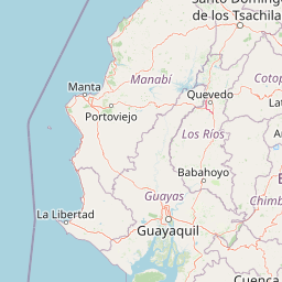
Map view of Reserva de producción de fauna Manglares El Salado

Use this park location map to pinpoint Reserva de producción de fauna Manglares El Salado in Ecuador, understand its exact geographic position, and read its mapped placement within the surrounding landscape more clearly.

Pigeon | © OpenStreetMap contributors

Location context for Reserva de producción de fauna Manglares El Salado

Guayas
Park atlas

Compare surrounding estuarine reserves, tidal channels, and regional coastal habitats.

Other Parks Near Reserva de producción de fauna Manglares El Salado and Coastal Protected Areas

Browse protected areas and national parks situated near Reserva de producción de fauna Manglares El Salado along the Ecuadorian coastline. Evaluating adjacent mangrove ecosystems and estuarine landscapes provides broader geographic context for regional conservation.
A horizontal watercolor painting showing a stylized forest landscape with soft pastel green, yellow, and pink hues representing trees and rolling hills.
Protected areaGuayas
About 11 km away#1 closest

Northwest

Bosque Protector Cerro Blanco: Protected Area and Tropical Dry Forest Geography in Guayas

Mapped terrain of the Chongon-Colonche mountain range

Bosque Protector Cerro Blanco functions as a major conservation site in coastal Ecuador, protecting rare Tumbesian forest ecosystems within the Guayas province. The reserve features diverse topography of ridges and valleys, serving as a critical buffer for regional endemic species and offering a unique look at seasonally dry forest landscapes near Guayaquil.

Area
60.78 km²
Established
1992
Visitors
12K annual
Relief
Upland
Nature reserveGuayas
About 12 km away#2 closest

North

Bosque Protector La Prosperina Nature Reserve and Coastal Ecuador Forest Geography

Protected dry forest habitat and regional geographic terrain

Bosque Protector La Prosperina represents a critical survival of Ecuador's equatorial dry forest within the Guayas province. This nature reserve offers deep insight into seasonal ravine networks, drought-adapted vegetation, and the structural dynamics of fragmented coastal landscapes near Guayaquil.

Area
2.424 km²
Established
1994
Relief
Upland
Climate
Tropical
A pale, soft watercolor painting showing a stylized, rolling landscape with light green, pink, and yellow hues representing hills and trees.
Nature reserveGuayas Province
About 17 km away#3 closest

Southeast

Reserva ecológica Manglares Churute: Mapping a Coastal Nature Reserve in Guayas Province

An ecological mosaic of mangrove forests, estuaries, and forested ridges.

Spanning from the inner Gulf of Guayaquil into the Churute hill range, Reserva ecológica Manglares Churute acts as an essential protected area within Ecuador. The region contains one of the country's most significant mangrove complexes, complemented by freshwater lagoons and unique fog-affected forest summits that support diverse wildlife populations and endemic vegetation.

Area
471.74 km²
Established
1979
IUCN
Ia
Relief
Mixed relief
Wildlife reserveGuayas
About 43 km away#4 closest

Southwest

Refugio de Vida Silvestre Manglares El Morro: Protected Coastal Landscape and Map

A strategic marine and mangrove ecosystem in the Guayas Province

The landscape of Refugio de Vida Silvestre Manglares El Morro consists of continuous mangrove forests and rocky farallones, linked by a complex network of tidal channels. This wildlife refuge serves as an essential marine habitat at the threshold of the Gulf of Guayaquil, showcasing the interplay between tidal aquatic systems and coastal vegetation across the southwestern Ecuadorian region.

Area
101.3 km²
Established
2007
IUCN
Ib
Visitors
23K annual
Watercolor painting of a mountain landscape with a lake, rolling hills, and coniferous trees in soft green and yellow tones.
National parkAzuay
About 91 km away#5 closest

Southeast

Parque nacional Cajas: Mapping the Glacial Lakes and Paramo of the Ecuadorian Andes

Geographic analysis of high-elevation protected lands

Parque nacional Cajas encompasses a rugged, glacial-sculpted plateau characterized by cushion vegetation, boggy wetlands, and frequent fog. This protected area offers deep insight into the highland Andean geography of Azuay, where water bodies and mountain ridges intersect to form an essential ecological and cultural corridor for the region.

Area
293.89 km²
Established
1977
IUCN
II
Visitors
53K annual
Wildlife reserveLos Rios
About 94 km away#6 closest

Northeast

Refugio de Vida Silvestre Samama Mumbes: Foothill Forest and Protected Area Map

Mapping the western Andean slopes and Chocó forest fragments

Refugio de Vida Silvestre Samama Mumbes protects one of the final remnants of the Chocó Ecuatorial forest in the Ecuadorian Andes. This reserve encompasses steep, dissected ridges and vital river catchments, supporting endemic orchids, birds, and amphibians within a highly modified regional landscape. Gain deeper insight into its forest boundaries and watershed contribution.

Area
21.456 km²
Established
2016
IUCN
IV
Relief
Mountain
A horizontal watercolor painting showing a pale green and soft pink landscape with rolling hills in the background, a flat expanse of light green vegetation in the midground, and a suggestion of water in the foreground.
Marine protected areaSanta Elena
About 100 km away#7 closest

West

Reserva Marina El Pelado: Coastal Marine Protected Area and Underwater Reef Geography

Oceanic convergence zone within the Santa Elena province

Reserva Marina El Pelado features a distinct maritime landscape defined by thirteen submarine shoals, octocoral forests, and coastal mangrove systems. Located within the Santa Elena province, this protected area serves as an essential biological laboratory where tropical and temperate current systems collide, shaping a complex mosaic of rocky reefs and diverse marine habitats.

Area
131.55 km²
Established
2012
IUCN
VI
Relief
Lowland
National parkManabí Province
About 102 km away#8 closest

Northwest

Machalilla National Park: Protected Area and Geographic Context in Manabí Province

Explore mapped natural landscapes and regional geography.

Delve into Machalilla National Park, a protected national park situated in Ecuador's Manabí Province. This page provides a focused view on its protected landscape character, emphasizing its geographic setting and mapped natural terrain. Understand how Machalilla National Park fits into the regional geography, offering a distinct case study for protected-area discovery and landscape atlas exploration.

Area
750.59 km²
Established
1979
IUCN
II

Common questions about visiting, size, designation, and location context for Reserva de producción de fauna Manglares El Salado

Reserva de producción de fauna Manglares El Salado FAQs for park facts, access, geography, and protected area context

Find quick answers about Reserva de producción de fauna Manglares El Salado, including protected-area facts, park geography, trail and visitor context, and how the park fits into its surrounding country and regional landscape.
MoriAtlas Explorer

Continue Your Protected Areas Search Across the Global Atlas

Deepen your exploration by continuing the structured search for national parks and protected areas worldwide. Utilize the comprehensive filtering capabilities to compare different conservation landscapes and refine your understanding of global park geography. Discover more about the distribution and characteristics of protected natural areas.

Global natural geography