Why Mariusa National Park stands out
Mariusa is best known for the extraordinary juxtaposition of dense tropical rainforest and tidal influence at the mouth of the Orinoco, one of the largest river systems in South America. The park's defining identity is the network of caños, or distributary channels, that radiate through the delta and carry ocean tides deep into otherwise freshwater terrain. Combined with morichales, mangrove formations, and a wildlife profile that includes manatees, river dolphins, Orinoco caimans, scarlet ibises, and blue-and-yellow macaws, Mariusa stands out as a showcase of large tropical river delta ecology. Its integration into the UNESCO-recognized Orinoco Delta Biosphere Reserve reinforces its status as one of Venezuela's most irreplaceable wetland landscapes.
Mariusa National Park history and protected-area timeline
The modern protection of Mariusa traces to June 5, 1991, when the Venezuelan government formally established the park and placed it under INPARQUES, the national body responsible for the country's protected areas. The designation recognized both the ecological singularity of the central Orinoco Delta and the need to safeguard a landscape long inhabited and shaped by the Warao people.
A broader international milestone came in 2007, when the Orinoco Delta region, of which Mariusa is a core component, was inscribed as a UNESCO Biosphere Reserve during the 31st session of the World Heritage Committee. The biosphere recognition highlighted criteria related to the area's outstanding ecological processes and its role as a representative example of a major tropical river delta system. Together, the 1991 national park creation and the 2007 biosphere inscription mark the two defining milestones in Mariusa's relatively short but internationally significant protection history.
Mariusa National Park landscape and geographic character
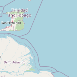
The physical setting of Mariusa is essentially a vast, living delta. The Orinoco arrives from the south and west, fed by more than 200 major rivers, and fans out across an arc roughly 2,150 kilometers long before meeting the Atlantic. The river's two principal branches, the Río Grande and the Brazo Manamo, organize the entire deltaic plain, while a near-infinite number of secondary channels, locally called caños, weave through the lowlands. Within this system, Mariusa preserves a central slice where the channels are most distinctive and where the largest floodable island, Isla Redonda, sits framed by the Macareo and Mariusa distributaries.
The land itself is the product of long-term Quaternary sediment accumulation, building a low, soft plain that is reshaped continuously by deposition, erosion, and tidal pulses. Tides penetrate surprising distances up many caños, which means that salinity, freshwater flow, and sediment load interact across the whole protected area rather than being confined to the coast. This dynamic is responsible for the transition between purely freshwater swamp forest, mixed-influence mangroves, and morichales on slightly better-drained sites. The result is a landscape where elevation differences are extremely subtle but ecological contrasts are dramatic.
Mariusa National Park ecosystems, habitats, and plant life
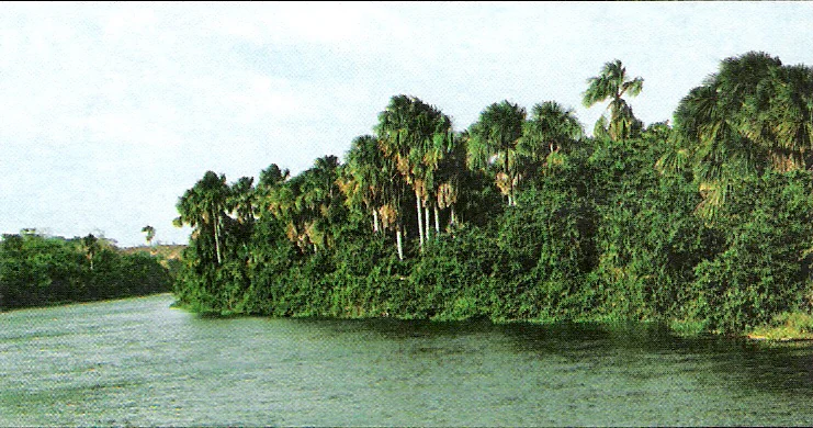
Mariusa's ecological identity is that of a tropical river delta at peak diversity. The park protects a representative cross-section of the formations that define the central Orinoco Delta. In the lowest, wettest positions, evergreen hydrophilous forests dominated by hydrophilic species hold the ground, often seasonally or permanently saturated. Morichales, the distinctive palm swamps built around Mauritia flexuosa, occupy broad areas where groundwater sits close to the surface and create some of the most visually striking formations in the delta. Along tidal channels and toward the coast, mangroves form dense, salt-tolerant fringes that mediate between freshwater outflow and marine influence. Scattered patches of savanna, held on slightly higher ground, break up the forested matrix.
This habitat mosaic supports unusually high biodiversity because freshwater, brackish, and tidal influences all meet within the same protected boundary. The park's ecological value is not just in any single formation but in the way river process, tidal process, and forest succession operate together. That complexity is what made the wider delta worthy of biosphere recognition and what continues to make Mariusa one of Venezuela's most ecologically representative protected areas.
Mariusa National Park wildlife and species highlights
The wildlife profile of Mariusa reflects the convergence of river, swamp, and tidal environments typical of a major tropical delta. Aquatic life is especially rich, with notable fish species including the four-eyed fish, caribes, catfish of various kinds, guabinas, and snook, all of which thrive in the shifting salinity gradients of the caños.
Reptiles are similarly prominent. The Orinoco caiman and the coastal caiman inhabit the channels and flooded forests, while babos, including morichalero and llanero forms, share the swampy terrain. Mammals in and around the park include the manatee, the tonina (a river dolphin), the giant otter, the capybara, monkeys, sloths, and a range of rodents. Birdlife is particularly noteworthy, with 187 recorded species encompassing the spoonbill, the magnificent frigatebird known locally as tijereta de mar, the scarlet ibis, the osprey, and the blue-and-yellow macaw, whose bright presence over the canopy has become emblematic of the delta landscape.
Mariusa National Park conservation status and protection priorities
Mariusa National Park matters at a national level because it anchors protection of the central Orinoco Delta, one of the largest and most ecologically distinctive river deltas in South America. The park's IUCN Category II status reflects its role as a strictly protected area where natural processes are meant to be maintained across an unusually complete mosaic of wetland habitats. The combination of flooded evergreen forest, morichales, mangroves, and savanna patches within a single protected boundary means that Mariusa safeguards multiple ecosystems at once, rather than focusing on a single habitat type.
Internationally, the park sits at the core of the wider Orinoco Delta Biosphere Reserve, inscribed by UNESCO in 2007 to recognize the delta's outstanding ecological processes and its global significance as a representative example of a major tropical river system. The biosphere designation criteria emphasize both the area's ecological value and its role as a model for integrated conservation of a populated deltaic landscape. The continued protection of Mariusa is therefore central to keeping the Orinoco Delta functioning as an intact natural system while supporting the Warao communities who have long inhabited its channels and islands.
Mariusa National Park cultural meaning and human context
The cultural landscape of Mariusa is inseparable from that of the Warao people, who have been the dominant human presence in the Orinoco Delta for many centuries. The Warao have built their livelihoods, settlements, and traditional knowledge around the same caños, islands, and flooded forests that today define the park. Their deep familiarity with tides, fish, and seasonal flooding is part of what gives the delta its character as a working inhabited landscape rather than an untouched wilderness.
This long-standing indigenous presence is part of why the broader Orinoco Delta was recognized as a UNESCO Biosphere Reserve, since the biosphere model explicitly accommodates areas where conservation and human cultural landscapes overlap. Within Mariusa, cultural context therefore does not sit alongside ecology; it is woven into the way the wetland has been understood, used, and sustained over generations.
Top sights and standout views in Mariusa National Park
Mariusa's strongest highlights cluster around its role as the protected core of the Orinoco Delta. Among the most distinctive features are the tidal caños of the central delta, the seasonally flooded evergreen forests and morichales that cover most of the park, and the mangrove systems along the lower channels. Wildlife highlights include the chance to encounter Orinoco caimans, manatees, river dolphins, giant otters, scarlet ibises, ospreys, and blue-and-yellow macaws within the same landscape. The park's UNESCO Biosphere Reserve status, alongside its status as a Venezuelan national park since 1991, ranks it among the most internationally recognized wetland protected areas in northern South America.
Best time to visit Mariusa National Park
Mariusa's character shifts with the rhythm of the Orinoco and the Atlantic. In the dry season, when river levels fall and tides more clearly dominate certain caños, the delta's channels can become more navigable, and wildlife tends to concentrate around remaining water bodies. In the wet season, higher water expands the flooded forest and morichales, intensifying the wetland character of the landscape and bringing freshwater influence further downstream. Both seasons offer different expressions of the delta, but visitors should expect that any visit is shaped by water levels and tides rather than by predictable dry or mild weather patterns typical of other landscapes.