
Mori Atlas logo
Natural monumentMeandry Botiče

A detailed geographic study of meandering stream systems and riparian floodplain conservation zones

Meandry Botiče Natural Monument: Investigating the Protected Riverine Landscapes of Prague

(Přírodní památka Meandry Botiče)

Meandry Botiče serves as a critical protected natural monument located on the southeastern fringe of Prague, defined by its complex Botič stream system. This site preserves a distinct lowland riparian landscape featuring native alder and willow woodlands that support diverse avian populations. Through this mapping of the protected area, you can examine the interplay between natural river morphology and urban-adjacent conservation efforts.

river meanderslowland streamriparian woodlandurban naturebirdwatchingnatural monument
A colorful digital illustration of a stream winding through a forest, with steep earthen banks and lush trees in a stylized, flat design.

Meandry Botiče

Natural monument

Park overview

Structured park overview, official facts, and landscape profile for Meandry Botiče

Meandry Botiče park facts, protected area profile, and essential visitor context

Review the core facts for Meandry Botiče, including designation, size, terrain, visitor scale, habitats, and operating context in one park-focused overview.

About Meandry Botiče

Meandry Botiče occupies a distinctive niche among Prague's protected natural areas: it is not a remote wilderness, but a small, ecologically valuable fragment of a meandering lowland stream embedded within a metropolitan area. The protected section begins below the dam of the Hostivař Reservoir and continues through the southern districts of Hostivař, Práče, and Záběhlice. Together with the adjacent natural park Hostivař to Záběhlice, it forms a connected belt of greenery on the southeastern edge of the city.

The site contains not only the meandering stream itself but also bankside tree cover, wet meadows, and surrounding farmland underlain by alluvial floodplain soils. Its scientific importance stems from the combination of a relatively intact meander pattern with a wide variety of protected fauna and flora that have adapted to this urban-fringe environment. The stream forms an ecological corridor that links the Hostivař Reservoir with downstream habitats, allowing fish, amphibians, and water birds to move through an otherwise heavily built-up landscape.

Because the area lies close to large housing estates, it also functions as a daily-use natural space for walkers, runners, cyclists, dog walkers, and paddlers. Each autumn, the Botič stretch is used for the community paddling event Rio Botičo, which runs from the Hostivaŕ Reservoir down to the Vltava. The resulting pressure, including littering, trampling, off-path use, and nutrient overload from dog waste, creates one of the central management challenges for the site.

Despite being only a few hectares in extent, Meandry Botiče represents an unusually complete example of how a city can maintain a functioning lowland river ecosystem on its periphery.

Quick facts and research context for Meandry Botiče

Meandry Botiče is a Czech přírodní památka (natural monument) located in Prague, specifically in the districts of Hostivař and Záběhlice. It protects a meandering segment of the Botič stream between the Hostivař Reservoir and the area of Práče. The area sits roughly 220 to 235 meters above sea level and forms part of the larger Hostivař to Záběhlice Natural Park.

The site was first declared on 29 April 1968 and was reclassified as a přírodní památka in 1993. It is documented as an important ornithological locality and is also recognized for its aquatic fauna, amphibians, and riparian woodland. Management efforts focus on controlling invasive plants and reducing litter pressure from nearby residential neighborhoods.

Protection and recognition

Terrestrial conservation framework and official designation timeline

Meandry Botiče Protection Status and Designated Area History

Documented protection history for Meandry Botiče outlines terrestrial conservation measures established in 1993. Structured designation records trace official management scope and recognized status across the protected landscape.

Protection details

Protection scope
Terrestrial
Designated year
1993
Transboundary protection
No
Park context

Deeper park guide and search-rich context for Meandry Botiče

Meandry Botiče history, landscape, wildlife, and travel context

Explore Meandry Botiče through its history, landscape character, ecosystems, wildlife, conservation priorities, cultural context, and seasonal travel timing in a structured park guide built for atlas discovery and search intent.

Why Meandry Botiče stands out

Meandry Botiče is best known for preserving a remarkably natural, meandering lowland riverbed inside the city of Prague. Its bankside vegetation of alder and willow, combined with small-scale agricultural surrounding land, creates habitat for protected and endangered birdlife, including kingfishers, golden orioles, red-backed shrikes, and little owls. The area is also noted as a working example of urban-adjacent conservation, where active management continuously battles invasive plant species, litter, and recreational pressure from the surrounding residential districts.
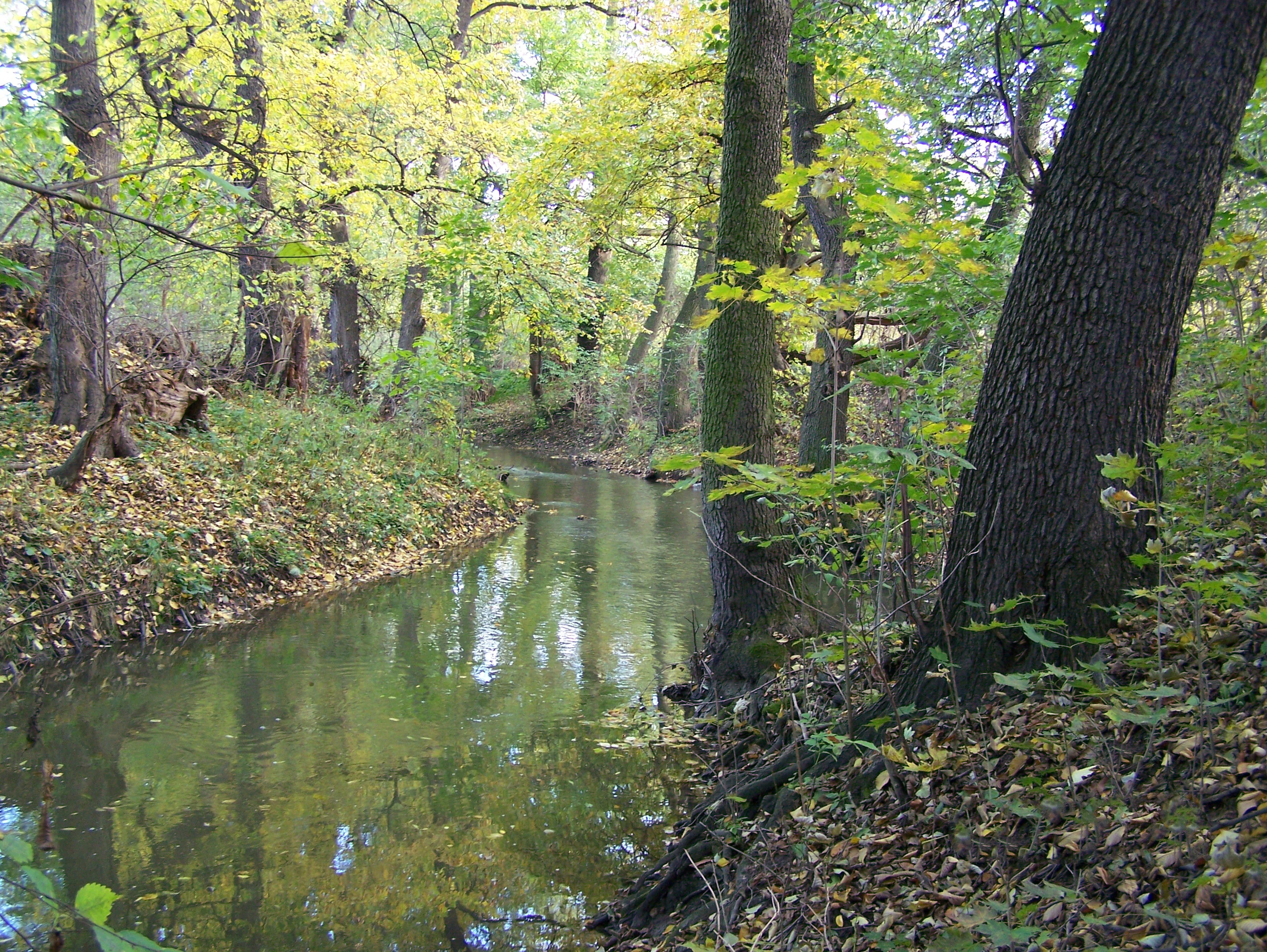
A calm, narrow stream winds through a dense deciduous forest in autumn, with golden and green foliage reflecting in the water.
The Botič stream flowing through the Meandry Botiče natural monument, characterized by its natural meanders and surrounding riparian forest.

Meandry Botiče history and protected-area timeline

The course of the Botič stream was shaped over a long geological period. Its meandering channel was originally cut during the late Pleistocene, between roughly 100,000 and 500,000 years ago, by the action of flowing water. In the Holocene, about ten thousand years ago, the previously silted-up channel was deepened again, opening the path for the modern stream to develop.

The floodplain soils that line the stream made agriculture possible from very early times. Archaeological and historical traces indicate that farmers cultivated the area for at least seven thousand years, supplying Prague with cabbage, other vegetables, and strawberries. Successive peoples, including Germanic communities, Celts, and Slavs, all left cultural layers in this landscape.

Meandry Botiče landscape and geographic character

The landscape of Meandry Botiče is centered on a slow-moving lowland stream that traces a pronounced meander pattern through a shallow valley. Elevations are modest, ranging only between roughly 220 and 235 meters, but the local relief is significant enough to create clearly visible bends, undercut banks, exposed sediment profiles, and small pools.
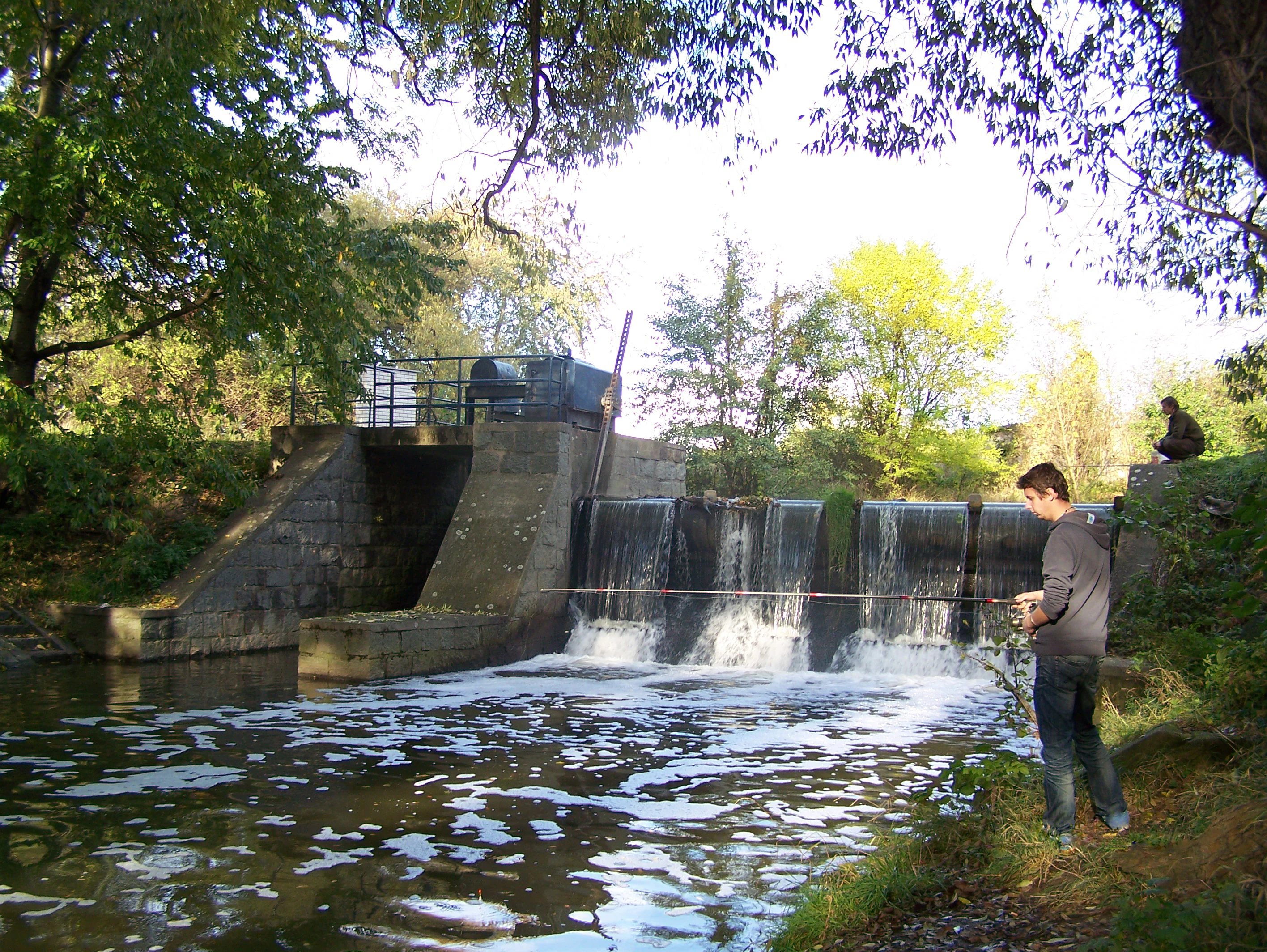
A man fishing with a rod on the bank of a small stream next to a stone and concrete weir, surrounded by trees.
A person fishing by the small weir on the Botič stream within the Meandry Botiče natural monument.

Meandry Botiče ecosystems, habitats, and plant life

Ecologically, Meandry Botiče belongs to the lowland floodplain habitat type, where the stream, its bankside vegetation, and adjacent farmland form a closely interconnected system. The combination of open water, wet banks, riparian woodland, and surrounding fields creates a mosaic of microhabitats that supports very diverse plant and animal communities despite the small overall size of the protected area.

Meandry Botiče wildlife and species highlights

Meandry Botiče is widely recognized as an important ornithological locality within Prague's network of protected sites. Documented protected and notable bird species include the golden oriole, red-backed shrike, little owl, common nightingale, and the common kingfisher, which nests directly in holes in the riverbank sediments. Mallards are common on the water, while common pheasants are frequent in the surrounding fields.

Meandry Botiče conservation status and protection priorities

Conservation management at Meandry Botiče is shaped by the tension between strong ecological value and intense urban pressure. The long-term goal is to preserve the natural course of the Botič and the rare organisms depending on it, while reducing the spread of invasive plant species and limiting pollution carried in from surrounding housing estates and farmland.

Meandry Botiče cultural meaning and human context

Although modest in scale, Meandry Botiče sits within an ancient cultural landscape. Floodplain agriculture along the Botič has been documented for around seven thousand years, with successive communities, from Germanic peoples through Celts to Slavs, leaving traces in the surrounding fields. Today, the area also carries modern community meaning: the annual Rio Botičo paddling event transforms the stream into a focal point of local urban identity.

Top sights and standout views in Meandry Botiče

Meandry Botiče is a compact but content-rich protected area, defined by a clear set of distinguishing characteristics. Its most distinctive features include a naturally meandering Botič stream bed, bankside woodland dominated by alder and willow, and a layered flora that mixes native spring-blooming woodland herbs with problematic invasive species requiring active control.

Best time to visit Meandry Botiče

Seasonal interest at Meandry Botiče shifts between the ecological rhythms of the stream and the recreational patterns of the city. Spring is the period when the woodland floor becomes most expressive, with flowering species such as hollowroot, marsh marigold, lesser celandine, wood anemone, and yellow anemone creating a short but rich display along the banks.

Monthly climate preview

Track monthly temperature ranges and precipitation patterns across the protected landscape

Meandry Botiče Climate Normals, Long Term Temperature and Precipitation Rhythm

Representative coordinate measurements record monthly mean temperatures ranging from minus two degrees Celsius to nearly twenty degrees alongside steady daily precipitation amounts. Examining the complete twelve month dataset reveals detailed long term climate normals across the protected area.
Annual mean9 °C
-2 °C20 °C
Jan-2°
Feb-1°
Mar
Apr
May13°
Jun17°
Jul20°
Aug19°
Sep14°
Oct
Nov
Dec-1°
Warmest month
July

19.7 °C

Coolest month
January

-2.2 °C

Wettest month
June

2.6 mm/day

Driest month
February

1.1 mm/day

Park location guide

Geography guide, regional context, and park location map for Meandry Botiče

Meandry Botiče park geography, regions, and map view in Czechia

Understand where Meandry Botiče sits in Czechia through a broader geographic reading of the surrounding landscape, nearby location context, and its mapped position within the national park landscape.

How Meandry Botiče fits into Czechia

Czech Republic is a landlocked Central European country with a population of approximately 10.9 million people. The nation was established as an independent state on January 1, 1993, following the dissolution of Czechoslovakia. Its capital and largest city is Prague, with other major urban centers including Brno, Ostrava, Plzeň, and Liberec.

Wider geography shaping Meandry Botiče in Czechia

The Czech Republic is a landlocked country in Central Europe. It is bordered by Germany to the west, Austria to the south, Poland to the northeast, and Slovakia to the southeast. The landscape is predominantly hilly, with the territory covering 78,871 square kilometers.

Map view of Meandry Botiče

Use this park location map to pinpoint Meandry Botiče in Czechia, understand its exact geographic position, and read its mapped placement within the surrounding landscape more clearly.

Pigeon | © OpenStreetMap contributors

Location context for Meandry Botiče

Prague

Visualizing the natural meandering riverbed, riparian woodland, and urban protected habitats of Meandry Botiče

Meandry Botiče Photos and Landscape Scenery Visual Exploration

Visual records capture the slow-moving lowland stream and bankside vegetation that define the protected landscape character of Meandry Botiče. Studying these field photographs reveals the intricate river bends, riparian habitats, and urban-adjacent conservation zones in vivid detail.

A calm, narrow stream winds through a dense deciduous forest in autumn, with golden and green foliage reflecting in the water.

A small stream flows past a steep, earth-toned alluvial sediment bank with exposed tree roots, surrounded by green riparian forest.

A man fishing with a rod on the bank of a small stream next to a stone and concrete weir, surrounded by trees.

Park atlas

Compare nearby lowland stream habitats and regional urban nature reserves

Explore Parks Near Meandry Botiče and Surrounding Protected Landscapes

Browsing other parks near Meandry Botiče reveals a diverse network of riparian corridors and protected natural monuments across the surrounding region. Extending the geographic comparison allows visitors to evaluate similar floodplain habitats and urban conservation reserves in greater detail.
A soft watercolor painting of a green landscape featuring a small body of water, rolling hills, and trees, painted in a minimalist style on a white background.
Protected landscapePrague
About 1.7 km away#1 closest

West

Hostivař-Záběhlice Nature Park: Protected Landscape and Mapped Prague Geography

River valleys and reservoir terrain within the capital city.

Hostivař-Záběhlice Nature Park represents a vital natural zone in Prague, characterized by the mature forests and meandering river paths along the Botič stream. This record highlights the park's geographic composition, including its reservoirs, lowland forest patches, and its function as a preserved natural corridor within the city.

Area
4.23 km²
Established
1990
Relief
Lowland
Climate
Temperate
A pale, soft-toned watercolor painting of a rolling landscape featuring a stream in the foreground, scattered trees in the midground, and faint mountains in the distant background.
Protected landscapePraha
About 3.2 km away#2 closest

South

Přírodní park Botič-Milíčov: Protected Landscape, River Valley, and Forest Map

A preserved green refuge featuring meandering streams and pond networks near Praha.

Přírodní park Botič-Milíčov stands as a significant protected landscape in Praha, defined by the seasonal flooding of the Botič and Pitkovický streams. The park hosts alluvial forests, a series of historic ponds, and archaeological traces of ancient mills. Through map-based exploration, identify the diverse terrain that includes rocky outcrops at Pitkovická stráň and extensive broadleaf woodlands on the edge of urban housing developments.

Area
8.24 km²
Established
1984
Relief
Lowland
Climate
Temperate
A soft, minimalist watercolor painting showing a green treeline against a pale pink and white background, suggestive of wetlands or ponds.
Natural monumentPrague
About 3.2 km away#3 closest

South

Milíčovský les a rybníky: Protected Landscape and Wetland Map in Prague, Czech Republic

Natural monument geography and forest-wetland habitat atlas

Milíčovský les a rybníky represents a core natural monument in southern Prague, featuring a mature deciduous forest integrated with a managed system of ponds. This protected area serves as a critical refuge for rare wetland and woodland species. Use the mapping tools to trace the terrain, from the dense oak-hornbeam canopy to the extensive reedbeds and aquatic environments that define this unique urban-edge landscape.

Area
1.047 km²
Established
1991
IUCN
III
Relief
Upland
A watercolor painting showing a panoramic landscape with a rocky quarry ledge in the foreground, green hills in the midground, and soft, pastel colored rolling hills in the background.
Natural monumentPrague
About 3.8 km away#4 closest

East

Rohožník, lom v Dubči: Geological Natural Monument and Protected Landscape in Prague

Analyzing the Ordovician quartzite and tectonic rock exposures of the Prague Plateau

Rohožník, lom v Dubči serves as a crucial natural monument in the Prague region, protecting abandoned quarries that showcase clear M-shaped tectonic folds and thick quartzite deposits. This site acts as a living laboratory for geological history, connecting archaeological finds with dry grassland communities in an otherwise suburban-agricultural landscape on the edge of the capital.

Area
0.034 km²
Established
1988
IUCN
III
Relief
Upland
A soft watercolor painting of a rural landscape with light green meadows and clusters of trees under a pale, washed-out sky.
Protected landscapePrague
About 5.1 km away#5 closest

East

Přírodní park Říčanka: Protected Landscape and Geographic Map of Eastern Prague

An analysis of rural corridors, aquatic systems, and forest terrain.

Přírodní park Říčanka preserves an extensive rural ribbon of meadows, arable fields, and woodland patches on the eastern edge of Prague. This structured overview details the park's topography, its historic fishpond chain along the Říčanský potok, and the various natural monuments that characterize this protected Czech landscape.

Area
4 km²
Established
1984
Relief
Lowland
Climate
Temperate
Nature reservePrague
About 7.6 km away#6 closest

Southwest

V hrobech Nature Reserve: A Protected Botanical Island within the Urban Landscape of Prague

Rare dry-grassland habitats in the Kamýk district

V hrobech is a designated nature reserve in Prague featuring 1.3 hectares of southeast-facing slopes and species-rich grassland. This site is home to rare thermophilic plants and represents an important example of intensive conservation management in an urban environment. Its protected boundaries connect with local forest fragments to maintain ecological value amidst the residential developments of Lhotka and Libuš.

Area
0.013 km²
Established
1988
IUCN
IV
Relief
Lowland
Nature reservePraha 5
About 9 km away#7 closest

West

Prokopské údolí Nature Reserve: Geological Mapping and Protected Area Discovery

A limestone karst landscape situated within the Praha 5 district

Prokopské údolí is an essential protected nature reserve in Praha 5, featuring a deep limestone valley that serves as a globally significant site for Paleozoic fossils and karst geography. This protected landscape encompasses a range of habitats including rock steppes, thermophilic woodlands, and volcanic outcrops, providing a unique look at urban-adjacent nature conservation and historical limestone quarrying within the Czech Republic.

Area
1.71 km²
Established
1978
IUCN
III
Relief
Upland
Natural monumentPrague
About 11 km away#8 closest

Northwest

Velká skála Natural Monument: Geological Protected Area within the Prague Plateau

A landmark siliceous rock outcrop in the Troja district

Velká skála offers a concentrated look at the geological heritage of central Bohemia. As a designated natural monument, the site protects a rare siliceous rock outcrop that contrasts with the rolling terrain of the surrounding Prague Plateau, serving as a vital reference for regional geomorphology.

Area
0.018 km²
Established
1968
IUCN
III
Relief
Upland

Common questions about visiting, size, designation, and location context for Meandry Botiče

Meandry Botiče FAQs for park facts, access, geography, and protected area context

Find quick answers about Meandry Botiče, including protected-area facts, park geography, trail and visitor context, and how the park fits into its surrounding country and regional landscape.
MoriAtlas Explorer

Continue Your Protected Areas Search Across the Global Atlas

Deepen your exploration by continuing the structured search for national parks and protected areas worldwide. Utilize the comprehensive filtering capabilities to compare different conservation landscapes and refine your understanding of global park geography. Discover more about the distribution and characteristics of protected natural areas.

Global natural geography