Why Mirima National Park stands out
Mirima National Park is best known for its spectacular and unusual sandstone formations that create a striking landscape of sheer cliffs, jutting pinnacles, and sheltered valleys. These ancient geological structures, composed of wind-deposited sandstones dating back hundreds of millions of years, produce a distinctive visual character often draw comparisons to the renowned Bungle Bungles of Purnululu National Park, though Mirima remains less widely known. The park provides visitors with accessible views of this dramatic terrain from various lookouts, with the Kununurra lookout offering particularly panoramic perspectives over the surrounding Ord River country. Beyond the geology, the area holds exceptional significance for its Indigenous heritage, with the Miriwoong people maintaining deep cultural connections to the landscape and rock art sites within the park boundaries.
Mirima National Park history and protected-area timeline
Mirima National Park was formally established in 1982 when the area was declared a national park under the Conservation and Land Management Act of Western Australia. Prior to this formal protection, the land had been part of the broader Kimberley pastoral and cultural landscape used by the Miriwoong people for millennia. The establishment of the park recognized both the outstanding natural values of the sandstone formations and the cultural significance of the area to Indigenous peoples. The park was initially managed by the Department of Conservation and Land Management, which later merged into the Department of Environment and Conservation, now known as the Department of Biodiversity, Conservation and Attractions. The alternative name Hidden Valley National Park has been commonly used alongside the Miriwoong name Mirima, reflecting both the park's physical character and its location within a valley system surrounded by rugged terrain.
Mirima National Park landscape and geographic character
The landscape of Mirima National Park is dominated by spectacular sandstone formations that create one of the most visually striking environments in the eastern Kimberley. The sandstone comprises ancient sedimentary layers that have been eroded into a remarkable variety of forms, including vertical cliffs, steep-sided ridges, crumbling spires, and smooth-walled gorges. The characteristic red and orange hues of the sandstone are typical of the Kimberley's geological heritage, with iron oxide staining providing the distinctive coloration. Between the rock ridges, narrow valleys and shaded gorges offer protected environments quite different from the exposed ridgelines. The park sits at the edge of the Kimberley Plateau, with the terrain rising sharply from the surrounding flat plains that flank the Ord River valley. The overall effect is a landscape of dramatic contrast, with the bold sandstone masses creating an almost fortress-like boundary around hidden pockets of sheltered terrain.
Mirima National Park ecosystems, habitats, and plant life
The natural environment of Mirima National Park reflects the harsh but ecologically diverse conditions of the Kimberley tropical savanna. Vegetation across the park adapts to the rocky substrate and seasonal climate extremes, with various tree and shrub species scattered across the sandstone slopes and valley floors. The park sits within a broader landscape of savanna woodlands that cover much of the Kimberley, though the specific rock habitat supports plants specially adapted to survive on sandstone surfaces with limited soil development. The region's biodiversity includes numerous bird species, reptiles adapted to the rocky environment, and various mammals that inhabit the woodland and rocky areas. The contrast between the exposed sandstone surfaces and the more protected valley environments creates habitat diversity that supports different ecological communities within a relatively compact area.
Mirima National Park wildlife and species highlights
Wildlife in Mirima National Park reflects the broader biodiversity of the Kimberley region, with various bird species being particularly prominent in the park's observations. The rocky sandstone environment provides nesting habitat for several bird species, while the surrounding woodlands support additional fauna. Reptiles including various lizard species are well adapted to the rocky terrain and warm climate. The park's location adjacent to the Ord River floodplain also means wildlife may move between the river environments and the sandstone uplands, particularly during wet season periods when water flows increase across the landscape. While detailed species inventories are limited in the available source material, the park clearly supports resident populations of native animals adapted to the Kimberley's distinctive seasonal patterns of wet and dry seasons.
Mirima National Park conservation status and protection priorities
Mirima National Park represents an important protected area within the Kimberley region, preserving a distinctive sandstone landscape that might otherwise face pressures from development or pastoral use. The park's establishment in 1982 formalized protection for the geological formations and associated ecosystems, ensuring the area would be maintained in its natural state. The protection status recognizes both the outstanding natural values of the sandstone formations and the cultural significance of the area to the Miriwoong people. As part of the Western Australian national park system, Mirima contributes to the broader conservation network that protects representative samples of the state's diverse landscapes and ecosystems. The park also serves an important role in providing accessible nature-based experiences for visitors to the Kununurra region, supporting both education and appreciation of the Kimberley's natural values.
Mirima National Park cultural meaning and human context
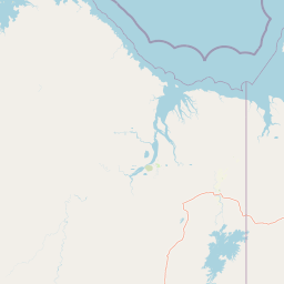
Mirima National Park holds profound cultural significance for the Miriwoong people, the Indigenous Traditional Owners of the land in the Kununurra region. The name Mirima encompasses not simply the immediate park area but describes a broader cultural landscape extending approximately 150 kilometres north and south and 170 kilometres east and west from Kununurra. This extensive area represents the traditional Country of the Miriwoong people, who have maintained continuous connections to this landscape through thousands of years of occupation and stewardship. Rock art sites within the park provide tangible evidence of this long-term Indigenous presence and cultural significance. The park thus represents both a natural and cultural heritage site, where the geological and ecological values intersect with the deep Indigenous cultural connections to the land.
Top sights and standout views in Mirima National Park
The most compelling highlight of Mirima National Park is its remarkable sandstone landscape, where ancient rock formations create a visually spectacular environment often compared to the Bungle Bungles but far more accessible from a major population centre. The Kununurra lookout provides panoramic views across the park and surrounding Ord River country, offering one of the most accessible elevated viewpoints in the far north Kimberley. Three walking trails allow visitors to explore different aspects of the park's terrain, from ridge-top walks to valley floor paths. The park's proximity to Kununurra means visitors can experience this dramatic landscape without extensive travel or logistical planning. The combination of geological wonder, Indigenous cultural significance, and accessible nature-based recreation makes Mirima a valuable introduction to the Kimberley's distinctive character.
Best time to visit Mirima National Park
Mirima National Park can be visited throughout the year, though the experience varies considerably between the wet and dry seasons. The dry season from May to October typically offers more comfortable conditions for walking and outdoor exploration, with lower humidity and minimal rainfall. The landscape during this period is generally more open and accessible, though some areas may appear brown and dry after months without significant rain. The wet season from November to April brings monsoon conditions to the Kimberley, with higher temperatures, humidity, and periodic heavy rainfall that can affect access and trail conditions. Some visitors prefer the green season when the landscape is more lush and waterholes may contain standing water. Regardless of season, visitors should be prepared for hot conditions and should avoid the hottest parts of the day.