
Mori Atlas logo
Nature reserveMittleres Kalltal

Geographic atlas and mapped boundaries of a vital low mountain stream and riparian habitat

Mittleres Kalltal Nature Reserve and Protected River Valley Landscapes in North Rhine Westphalia

(Naturschutzgebiet Mittleres Kalltal)

Mittleres Kalltal represents a significant protected corridor within the northern Eifel mountains of western Germany. This nature reserve, centered on the middle reach of the Kall river, encompasses a steep, V shaped valley defined by mature beech and oak forests, alder floodplains, and near natural stream topography. Its compact boundaries serve as an essential habitat for threatened aquatic species and diverse forest communities, reflecting the rich environmental heritage of the Simmerath region.

nature reserveriparian habitatlow mountain streamriver valleybeech forestoak forest
A flat-style digital illustration depicting a mountain valley, a cascading waterfall, a river flowing through the foreground, and surrounding forest vegetation.

Mittleres Kalltal

Nature reserve

Park overview

Structured park overview, official facts, and landscape profile for Mittleres Kalltal

Mittleres Kalltal park facts, protected area profile, and essential visitor context

Review the core facts for Mittleres Kalltal, including designation, size, terrain, visitor scale, habitats, and operating context in one park-focused overview.

About Mittleres Kalltal

Mittleres Kalltal is a small but ecologically focused nature reserve in the western Eifel region of Germany, anchored on a roughly two kilometer section of the Kall river in the municipality of Simmerath. The valley lies just south of the Kallstausee reservoir and extends upstream toward the L 160 state road, occupying the steep, narrow floor of a classic V-shaped low mountain valley.

The reserve's identity is built around the river itself. In this stretch the Kall flows as a near-natural mid-sized stream with a stony to gravelly bed, visible pools formed by scour around boulders, and an adjacent floodplain of alder wetland forest. On the slopes above, beech and oak dominate the canopy, while on the south-facing side of the valley remnant patches of gorge woodland survive on rocky, shaded ground. Spruce stands are present but are considered ecologically out of place, and a long-term restoration aim is their gradual replacement by native broadleaf forest.

The protected area is part of the European Natura 2000 ecological network and is managed under the Simmerath landscape plan by the lower landscape authority of the Städteregion Aachen. Its designation reflects an explicit aim to maintain an undisturbed stream reach as a refuge for aquatic communities, while also preserving the terrestrial habitats that line the valley. The combination of free-flowing water, floodplain, and mature valley forest gives the site a compact but unusually complete cross-section of northern Eifel wetland and forest ecology.

Quick facts and research context for Mittleres Kalltal

Mittleres Kalltal is a 42 hectare nature reserve located in Simmerath within the Städteregion Aachen, North Rhine-Westphalia, Germany. Officially designated in 1999, it carries the national reference code ACK-077 and the WDPA protected-area ID 318795, and overlaps with the Natura 2000 site DE-5303-302.

The reserve is managed by the lower landscape authority of the Städteregion Aachen under the Simmerath landscape plan, and is classified as an IUCN Category IV Habitat/Species Management Area. It protects a near-natural section of the Kall river together with adjacent beech, oak, and gorge woodland, and is recognized for its importance in conserving threatened riparian species under the EU Habitats Directive.

Protection and recognition

Examine documented conservation standing, management frameworks, and official records.

Mittleres Kalltal Protection Status and Designated Terrestrial Scope

Terrestrial protection status and formal designation records provide structured insight into the management scope of Mittleres Kalltal. Official database entries compile verified administrative parameters and conservation listings for accurate geographical reference.

Protection details

Protection scope
Terrestrial
Transboundary protection
No
WDPA ID
318795
Park context

Deeper park guide and search-rich context for Mittleres Kalltal

Mittleres Kalltal history, landscape, wildlife, and travel context

Explore Mittleres Kalltal through its history, landscape character, ecosystems, wildlife, conservation priorities, cultural context, and seasonal travel timing in a structured park guide built for atlas discovery and search intent.

Why Mittleres Kalltal stands out

Mittleres Kalltal is best known for protecting one of the most intact stretches of the Kall river, where the watercourse still displays the natural gravel and boulder bed, pools, and flow patterns of a low mountain stream. The reserve anchors the ecological value of the river corridor between the Kallstausee reservoir and the lower valley. It is equally valued for its surrounding forest mosaic, which combines species-rich beech and oak stands, alder floodplain forest, and relict gorge woodland on the south-facing slopes. Together these habitats support a dense community of red-listed plants, fish, bats, and breeding birds associated with mature, structurally diverse valley forests in the Eifel uplands.
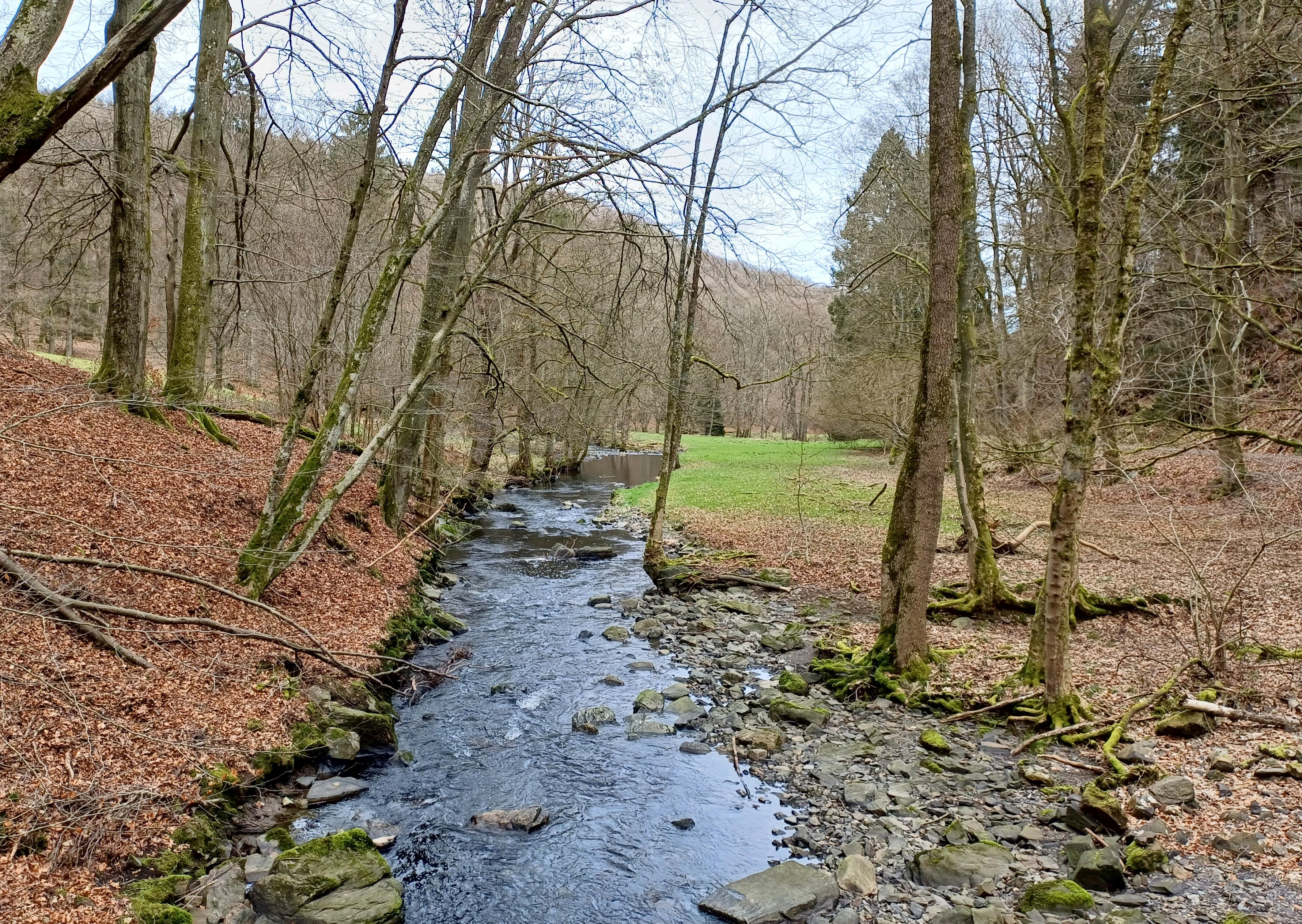
A small river flowing through a deciduous forest in autumn with fallen leaves covering the ground.
The Kall river flowing through the Mittleres Kalltal nature reserve.

Mittleres Kalltal history and protected-area timeline

Mittleres Kalltal was formally designated as a nature reserve in 1999 under the landscape planning framework of the municipality of Simmerath. The designation brought the middle reach of the Kall river and its immediate valley forests under formal protection, following recognition of the site's high ecological value as one of the least altered stream sections in the region.

The reserve was integrated into the broader European Natura 2000 network shortly afterward, reinforcing its role in conserving threatened habitats and species listed under the EU Habitats Directive. Management responsibility was assigned to the lower landscape authority of the Städteregion Aachen, and the site has since served as a reference area for stream and valley forest conservation in the northern Eifel.

Mittleres Kalltal landscape and geographic character

The defining landscape feature of Mittleres Kalltal is a steep, narrow V-shaped valley carved by the Kall into the low mountains of the northern Eifel. The slopes rise sharply from the river, and the valley floor is broad enough only for the river itself, its immediate floodplain, and a thin ribbon of riparian woodland.

The riverbed is composed of stones and coarse gravel typical of upland streams, with natural pools where water has scoured around larger boulders. Where the terrain allows, the valley bottom opens slightly into a flat floodplain of soft, waterlogged ground dominated by alder. On the steeper slopes, mature beech and oak forest covers most of the surface, while relict stands of gorge woodland cling to shaded rock outcrops on the south-facing side. Small surface exposures of bedrock occur along the valley walls, adding to the structural diversity of the terrain.

Mittleres Kalltal ecosystems, habitats, and plant life

The ecological character of Mittleres Kalltal is shaped by the close interaction between the river and its valley forests. The free-flowing Kall provides habitat for aquatic invertebrates and fish communities typical of near-natural European low mountain streams, while the surrounding forests filter the water, regulate flow, and supply woody debris that structures the riverbed.

The valley vegetation forms a clear gradient from wet to dry. On the valley floor, alder-dominated floodplain woodland thrives on periodically inundated ground, while the slopes carry mixed beech and oak stands with a rich understory. On rocky, shaded faces, relict gorge woodland survives, hosting ferns and moisture-loving plants less common elsewhere in the region. Springs and fragments of wet grassland add further habitat variety within the otherwise forested catchment. The combination of these habitats supports the full Annex I habitat types for which the site is designated under the Habitats Directive.

Mittleres Kalltal wildlife and species highlights

The reserve supports a notable concentration of species tied to clean, structurally diverse river systems and mature valley forest. The river itself provides habitat for fish and aquatic invertebrates characteristic of near-natural low mountain streams, while the surrounding forests shelter bats and forest-breeding birds.

Documented species of conservation interest include the European beaver, which uses the river corridor, and bat species such as the greater mouse-eared bat and the pond bat, which roost and forage along the wooded slopes and water margins. The bird life includes the kingfisher, whinchat, and black woodpecker, all associated with mature, water-rich forest landscapes. On the botanical side, rare plants such as beinbrech and the lungwort gentian contribute to the site's significance. The combination of aquatic, riparian, and forest habitats gives the reserve a vertically layered wildlife profile unusual for such a compact area.

Mittleres Kalltal conservation status and protection priorities

Mittleres Kalltal is recognized as a key site for the conservation of near-natural stream ecosystems and associated valley forests in the northern Eifel. Its designation under the EU Habitats Directive ties its protection directly to the maintenance of specific Annex I habitat types, including spring habitats, wet and moist grassland, unconstrained natural stream sections, exposed rock surfaces, and floodplain forest.

The reserve also plays a role in safeguarding species listed under the Habitats Directive, including the European beaver and several bat and bird species of conservation concern. Active management aims include the gradual replacement of ecologically unsuitable spruce stands with native broadleaf forest, the preservation of natural stream dynamics, and the maintenance of open rock and gorge woodland features. As an IUCN Category IV area embedded in the Natura 2000 network, Mittleres Kalltal functions less as a wilderness zone and more as a carefully managed refuge where natural processes and deliberate restoration work together to maintain habitat for threatened species.

Top sights and standout views in Mittleres Kalltal

Mittleres Kalltal stands out for the unusually high ecological density packed into its 42 hectare area. Within a short stretch of valley, visitors and managers encounter a near-natural mountain stream, an intact alder floodplain, mature beech and oak forest, and relict gorge woodland, all within sight of one another.

The reserve's integration into the European Natura 2000 network, its explicit Habitat Directive targets, and its role in conserving species such as the European beaver, kingfisher, and greater mouse-eared bat give it an outsized conservation significance for its size. Its location below the Kallstausee dam, accessible from the Simmerath landscape, also makes it a touchstone for understanding how low mountain river valleys can be protected while remaining embedded in a working cultural landscape.

Best time to visit Mittleres Kalltal

Mittleres Kalltal can be appreciated in any season, but late spring and early summer are generally the most rewarding for ecological interest. As the deciduous canopy closes, the river corridor becomes a shaded green tunnel, while ground flora in the beech and gorge woodland reaches its peak. Early morning visits in this period increase the chance of seeing riparian birds and glimpsing beaver activity along the water.

Autumn brings a quieter, more contemplative atmosphere, with the valley forest taking on warm color tones and the river often running lower and clearer, making its gravel bed and pools more visible. Winter visits emphasize the structural character of the valley itself, with bare trees opening views of the river's course, exposed rock outcrops on the slopes, and the contrast between the floodplain and the surrounding spruce stands that are gradually being replaced through ongoing restoration work.

Monthly climate preview

Long-term representative monthly averages for temperature and precipitation

Mittleres Kalltal Climate Normals and Annual Temperature Rhythm

Historical climate data for Mittleres Kalltal records monthly mean temperatures ranging from sub-zero winter minimums to warm summer maximums alongside steady precipitation rates. Reviewing the complete twelve-month profile provides detailed meteorological context for this protected natural area.
Annual mean8 °C
0 °C17 °C
Jan
Feb
Mar
Apr
May11°
Jun15°
Jul17°
Aug17°
Sep13°
Oct
Nov
Dec
Warmest month
July

17 °C

Coolest month
January

-0 °C

Wettest month
December

3.1 mm/day

Driest month
April

1.9 mm/day

Park location guide

Geography guide, regional context, and park location map for Mittleres Kalltal

Mittleres Kalltal park geography, regions, and map view in Germany

Understand where Mittleres Kalltal sits in Germany through a broader geographic reading of the surrounding landscape, nearby location context, and its mapped position within the national park landscape.

How Mittleres Kalltal fits into Germany

Germany is a federal republic in Western and Central Europe with a population of over 83 million across sixteen constituent states. It is Europe's largest economy by nominal GDP and a major global exporter and importer. The capital is Berlin, and the country borders Denmark, Poland, Czech Republic, Austria, Switzerland, France, Luxembourg, Belgium, and the Netherlands.

Wider geography shaping Mittleres Kalltal in Germany

Germany is located in Western and Central Europe, spanning 357,022 km². It borders Denmark to the north, Poland and the Czech Republic to the east, Austria and Switzerland to the south, and France, Luxembourg, Belgium, and the Netherlands to the west. The country has coastlines on the Baltic Sea and North Sea to the north, with the Alps located in the southern region.

Map view of Mittleres Kalltal

Use this park location map to pinpoint Mittleres Kalltal in Germany, understand its exact geographic position, and read its mapped placement within the surrounding landscape more clearly.

Pigeon | © OpenStreetMap contributors

Location context for Mittleres Kalltal

North Rhine-Westphalia

Explore the terrain, low mountain stream habitats, and forest mosaic of the protected reserve

Mittleres Kalltal Photos and Landscape Scenery: Visualizing the Protected River Valley

Visual documentation captures the steep V-shaped valley, near-natural boulder riverbed, and mature beech forests defining Mittleres Kalltal. Examining these protected habitats clarifies the ecological character of the northern Eifel stream corridor.

A small river flowing through a deciduous forest in autumn with fallen leaves covering the ground.

Park atlas

Compare adjacent river valleys, upland forests, and protected natural areas

Explore Parks Near Mittleres Kalltal and Surrounding Protected Landscapes

Visitors reviewing Mittleres Kalltal can continue browsing other protected areas in the surrounding region to compare upland stream valleys and forest habitats. Evaluating adjacent reserves provides broader geographic context on northern Eifel conservation landscapes.
Watercolor painting of a rolling stream valley with soft green hills and light water
Nature reserveStädteregion Aachen
About 1.7 km away#1 closest

West

Kelzer- und Saarscher Bachtal: Protected Brook Valley Geography and Forest Terrain

Nature reserve exploration in the Städteregion Aachen landscape

The Kelzer- und Saarscher Bachtal nature reserve protects a vital network of brook valley habitats, including deciduous forest remnants, wet heath, and cascading stream sections. This area offers a clear look at local hydrologic restoration and the structural diversity found within the Eifel district, providing a focused view for those interested in regional protected-land geography.

Area
0.46 km²
Established
1999
IUCN
IV
Protected landscapeNordrhein-Westfalen
About 2.9 km away#2 closest

East

Buhlert: Protected Landscape and Woodland History in Nordrhein-Westfalen, Germany

Eifel forest terrain, military heritage, and ridge geography

Buhlert presents a unique study in regional geography, standing as a continuous forest ridge that anchors a piece of the mid-elevation Eifel. This protected area integrates environmental conservation with the preservation of significant wartime bunkers, bomb craters, and historical military paths that define the surrounding woodland and terrain.

Area
6.99 km²
Established
2004
IUCN
V
Relief
Mountain
A soft, horizontal watercolor painting of rolling green hills under a faint, warm-toned sky, with no sharp outlines.
Nature reserveNorth Rhine-Westphalia
About 4.7 km away#3 closest

Southwest

Lenzbach Nature Reserve: Protected Stream Valley and Habitat Connectivity in the Northern Eifel

Geographic atlas and ecological landscape context in North Rhine-Westphalia

Lenzbach Nature Reserve encompasses a near-natural headwater stream valley characterized by expansive wet grasslands and spring mires. As part of the Natura 2000 Kalltal und Nebentäler complex, the reserve serves as an essential ecological link within the cross-border landscape between Belgium and Germany, supporting diverse wetland flora and maintaining habitat connectivity for regional wildlife.

Area
0.11 km²
Established
1999
IUCN
IV
Nature reserveNordrhein-Westfalen
About 5 km away#4 closest

Southeast

Wolfs- und Wollebachtal Nature Reserve: Geographic Profile and Protected Stream Valleys

A vital deciduous forest and stream valley refuge in North Rhine-Westphalia

Wolfs- und Wollebachtal preserves a diverse mosaic of low mountain stream corridors and broadleaf forest types. This protected area connects several ecologically sensitive valley systems, offering a distinct contrast to surrounding forestry plantations through its meandering brooks, seepage springs, and preserved oak-hornbeam coppice habitats.

Area
0.487 km²
Established
1999
IUCN
IV
Relief
Upland
Nature reserveNorth Rhine-Westphalia
About 5.1 km away#5 closest

Southwest

Wollerscheider Venn: Mapping the Protected Peatland and Bog Terrain of North Rhine-Westphalia

A specialized wetland reserve on the Eifel border high plateau

Located in the municipality of Simmerath, Wollerscheider Venn preserves essential fragments of raised bog and swamp woodland within the larger Hohes Venn ecosystem. This reserve protects diverse habitats including juniper heath and Nardus grassland, serving as a critical refuge for bog-specialist butterflies and dragonflies in the Eifel region. Its mapped landscape offers a clear view into the conservation of rare peatland environments across western Germany.

Area
0.42 km²
Established
1961
IUCN
IV
A watercolor painting depicting rolling, soft-toned green hills and a foreground of trees and riparian vegetation.
Nature reserveNorth Rhine-Westphalia
About 5.4 km away#6 closest

West

Laubwald am Hasselbachgraben Nature Reserve in North Rhine-Westphalia

Protected Eifel forest and riparian stream landscape

Located in the Städteregion Aachen, Laubwald am Hasselbachgraben preserves a distinct mix of European beech, oak, and spruce. The reserve is anchored by the Hasselbach stream valley and the landmark Kreitzberg Naturwaldzelle, providing a critical study of near-natural woodland structure within the northern Eifel region.

Area
2.88 km²
Established
1999
IUCN
IV
Relief
Upland
Watercolor illustration of rolling green hills and meadows with patches of pink and yellow flowers
National parkNorth Rhine-Westphalia
About 5.7 km away#7 closest

Southeast

Eifel National Park: North Rhine-Westphalia Protected Area Atlas

Explore mapped boundaries and regional geography.

Gain a structured understanding of Eifel National Park, a key protected area within Germany's North Rhine-Westphalia region. This page focuses on its geographic identity, detailing mapped boundaries and offering context within the state's broader natural landscapes. MoriAtlas enhances your exploration by presenting Eifel National Park as a distinct entity within a larger geographic framework, ideal for atlas-based research and understanding protected land distribution.

Area
107 km²
Established
2004
IUCN
II
Relief
Upland
A watercolor painting showing a soft, pastel-colored landscape with a wetland in the foreground and gentle, rolling hills in the background.
Nature reserveNordrhein-Westfalen
About 6.1 km away#8 closest

West

Hoscheider Venn mit Quellgebieten des Dreiläger- und Schleebaches Nature Reserve Atlas

Protected raised bog and glacial pingo terrain in North Rhine-Westphalia

Hoscheider Venn mit Quellgebieten des Dreiläger- und Schleebaches safeguards a representative upland moor environment on the western edge of the Eifel. The reserve includes diverse habitats ranging from nutrient poor bog pools to acidophilous forests, maintaining active restoration zones for regenerating wet heath and peatland ecosystems across its unique topographic mosaic.

Area
1.96 km²
Established
1982
IUCN
IV
Relief
Upland

Common questions about visiting, size, designation, and location context for Mittleres Kalltal

Mittleres Kalltal FAQs for park facts, access, geography, and protected area context

Find quick answers about Mittleres Kalltal, including protected-area facts, park geography, trail and visitor context, and how the park fits into its surrounding country and regional landscape.
MoriAtlas Explorer

Continue Your Protected Areas Search Across the Global Atlas

Deepen your exploration by continuing the structured search for national parks and protected areas worldwide. Utilize the comprehensive filtering capabilities to compare different conservation landscapes and refine your understanding of global park geography. Discover more about the distribution and characteristics of protected natural areas.

Global natural geography