
Mori Atlas logo
Protected landscapeMittleres Lonetal

Examining the valley terrain, limestone plateau boundaries, and conservation landscape structure

Mittleres Lonetal: A Detailed Geographic Overview of the Protected Landscape in Baden-Württemberg

(Landschaftsschutzgebiet „Mittleres Lonetal")

Mittleres Lonetal encompasses a significant stretch of the Lone river valley as it carves through the limestone plateaus of the Swabian Alb. This protected landscape, situated within the Alb-Donau-Kreis district of Baden-Württemberg, preserves a mosaic of meadow dales, juniper heaths, and traditional orchards. The area serves as a vital corridor of natural terrain, bridging the higher karst plains and the lowland transitions toward the Danube.

protected landscapelandscape protection areaSwabian Albvalley landscapejuniper heathtraditional orchards
A stylized vector illustration featuring a grassy foreground; a valley with pine trees and deciduous trees on the sides; and a prominent waterfall cascading between cliffs in the background under a pale sky.

Mittleres Lonetal

Protected landscape

Park overview

Structured park overview, official facts, and landscape profile for Mittleres Lonetal

Mittleres Lonetal park facts, protected area profile, and essential visitor context

Review the core facts for Mittleres Lonetal, including designation, size, terrain, visitor scale, habitats, and operating context in one park-focused overview.

About Mittleres Lonetal

Mittleres Lonetal is one of the larger landscape protection areas within the Alb-Donau-Kreis, a district that encompasses a substantial slice of the Swabian Alb in Baden-Württemberg. The protected area follows the course of the Lone river through the middle reaches of its valley, between the town of Breitingen in the east and the Stetten ob Lontal district of Niederstotzingen in the west.

The area forms part of the broader Lonetal, a valley system famous regionally for its karst features, rock formations, and as a route connecting the Alb plateau with the Danube lowlands. While the Mittleres Lonetal protection area encompasses twelve municipalities rather than a single contiguous forest, it preserves a coherent cross-section of valley landscape: wet dales fed by so-called Hungerbrunnen, or intermittent karst springs, dry hill slopes clad in juniper and grassland, and flatter areas still worked as orchards and meadows.

The protection framework allows traditional land use to continue while shielding the land from large-scale change. Farming, forestry, and small-scale settlement all remain present, but they are balanced against preservation goals aimed at maintaining the diversity, character, and beauty of the valley landscape as it has historically developed on the Swabian Alb.

Quick facts and research context for Mittleres Lonetal

Mittleres Lonetal was formally established as a protected landscape on 2 March 1989 by decree of the lower nature conservation authority of the Alb-Donau-Kreis. It is registered under LSG number 4.25.103 and is also recorded in the World Database on Protected Areas with ID 323007, classified under IUCN Category V as a Protected Landscape or Seascape.

In 2003, the total area of the protected landscape was reduced when the Breitinger Schönrain nature reserve was established within its borders. The protected landscape itself is not a national park in the strict sense, but a classic German Landschaftsschutzgebiet, a category that focuses on preserving the visual, cultural, and ecological character of a culturally shaped working landscape.

Protection and recognition

Documented protection records and management designations for Mittleres Lonetal

Mittleres Lonetal Protection Status and International Recognition Data

Examine documented protection status, management scope, and official designation records compiled for Mittleres Lonetal. Review verified administrative data and international recognition metrics anchored to global protected area databases.

Protection details

WDPA ID
323007
Park context

Deeper park guide and search-rich context for Mittleres Lonetal

Mittleres Lonetal history, landscape, wildlife, and travel context

Explore Mittleres Lonetal through its history, landscape character, ecosystems, wildlife, conservation priorities, cultural context, and seasonal travel timing in a structured park guide built for atlas discovery and search intent.

Why Mittleres Lonetal stands out

Mittleres Lonetal is best known for protecting the characteristic valley landscapes of the Lone river as it crosses the Swabian Alb. The area combines meadow dales, juniper heaths, scattered orchards, and broadleaf forests into a coherent traditional landscape that reflects centuries of agricultural use on the Alb plateau. The protected landscape is also notable for its embedded nature reserve, Breitinger Schönrain, which sits at the core of the wider protected zone and highlights the ecological value of the Lone valley as a refuge for native flora and fauna within an otherwise farmed setting.
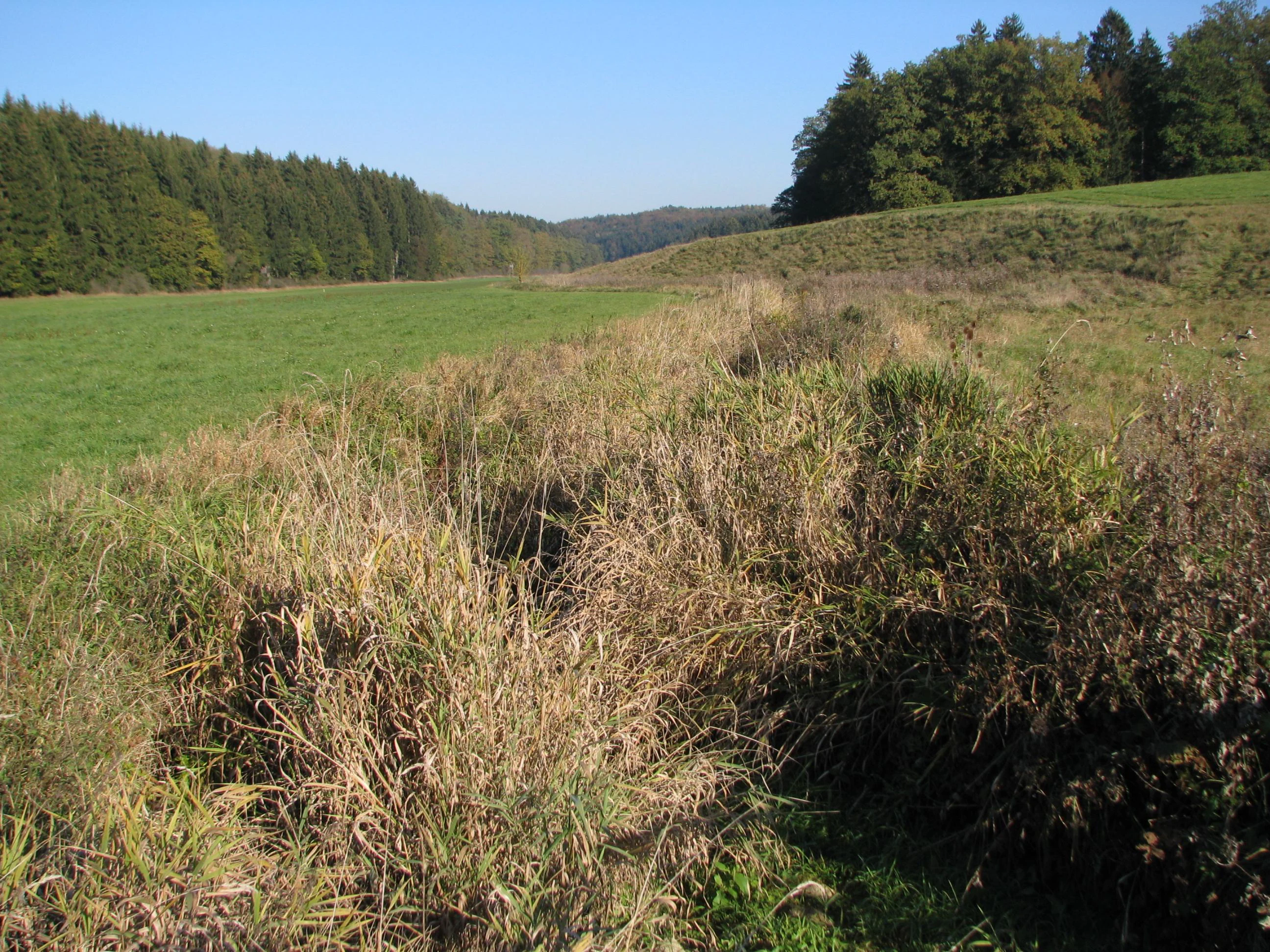
A wide view of a valley floor with a small, partially hidden river running through grasses and bushes, flanked by sloping hills and dense forests under a clear blue sky.
The Lone River valley landscape within Mittleres Lonetal, showcasing the characteristic valley floor and surrounding woodlands.

Mittleres Lonetal history and protected-area timeline

Mittleres Lonetal was officially designated as a protected landscape on 2 March 1989, following a decree issued by the lower nature conservation authority at the Alb-Donau-Kreis district office. From that point forward, the valley landscape between Breitingen and Stetten ob Lontal came under a formal regime intended to maintain its traditional ecological and visual character.

Fourteen years later, in 2003, the protection framework was refined. A portion of the original landscape protection area was carved out and elevated into a stricter nature reserve, the Breitinger Schönrain, whose boundaries lie entirely within the remaining protected landscape. This change reduced the overall protected landscape footprint but strengthened protection for the most ecologically valuable core area, creating a layered system in which the broader landscape protection area surrounds and buffers the inner nature reserve.

Beyond these formal milestones, the protected landscape reflects a long-standing regional tradition of recognizing the cultural and ecological value of the Lone valley. The Alb-Donau-Kreis hosts numerous adjacent landscape protection areas, and together they form a broader patchwork of protected, culturally rooted landscapes across the Swabian Alb.

Mittleres Lonetal landscape and geographic character

Mittleres Lonetal follows the valley of the Lone, a left-bank tributary of the Danube that cuts eastward into the Swabian Alb. The protected area is intentionally elongated, mirroring the linear shape of the valley it protects, and extends through twelve municipalities along several kilometers of valley corridor.

Geologically, the area sits within the Lonetal-Flächenalb, the natural region that bridges the rough karst surface of the central Swabian Alb and the softer, more gently rolling terrain toward the Danube. The valley floor collects water from Hungerbrunnen, intermittent springs that emerge from limestone fissures in dry weather and swell after rain, giving the meadows below them a moist, biologically rich character.

The flanks of the valley carry a more varied terrain: open slopes that have long been grazed, exposed rock outcrops and small cliff sections, isolated field copses, and patches of juniper heath. Traditional orchards, or Streuobstwiesen, combine with woodland edges and field tracks to produce the patchwork appearance that defines the protected area visually.

Mittleres Lonetal ecosystems, habitats, and plant life

Ecologically, Mittleres Lonetal functions as a mosaic of habitats rather than a single uniform ecosystem. The valley floor supports wet meadows and small wet dales with rich herbaceous vegetation, while the drier valley sides carry juniper heaths, rough grasslands, and fruit-tree meadows that depend on traditional management to survive.

Forest is a defining element. Mixed broadleaf woodland appears both as continuous stretches on steeper ground and as scattered woodland elements, Baumgruppen, and Waldlagen, that break the agricultural land into smaller units. These wooded patches, together with field copses, act as habitat corridors for woodland species and step between the wet valley floor and the drier slopes.

The Hungerbrunnen, the intermittent karst springs noted in the original protection decree, are small but distinctive natural features. They create localized wetland conditions during wet periods and act as biological refuges for moisture-dependent plants and invertebrates, adding subtlety to the ecological profile of the area.

Mittleres Lonetal wildlife and species highlights

Unlike many major national parks, Mittleres Lonetal does not support populations of large charismatic mammals. Its conservation significance lies instead in supporting a wide range of common native species that depend on the Swabian Alb landscape mosaic. The protected description explicitly highlights the preservation and promotion of habitats for local animal and plant life.

Juniper heaths and orchard meadows provide nesting structure and forage opportunities for farmland birds, while the broadleaf forest patches and woodland edges support typical woodland fauna including small mammals, bats, and a range of woodland bird species. The wet meadows and intermittent spring areas host amphibians, invertebrates, and moisture-loving plants that have become increasingly rare as valley floors elsewhere have been drained or intensively farmed.

The embedded Breitinger Schönrain nature reserve hosts the highest density of sensitive habitats within the broader landscape and provides the main concentration of protected wildlife interest in the area.

Mittleres Lonetal conservation status and protection priorities

Mittleres Lonetal was designated as a Landschaftsschutzgebiet under IUCN Category V, corresponding to a Protected Landscape or Seascape. This is a management category that recognizes landscapes shaped by long interaction between people and nature and focuses on maintaining the balance of cultural, scenic, and ecological values that define them.

The official protection decree sets out three core conservation goals: the preservation of diversity, character, and beauty of the Lone valley floodplains, with particular attention to meadow valleys, broadleaf forests, tree groups, wooded slopes, rock features, juniper heaths, traditional orchards, field copses, geological exposures, and intermittent springs; the conservation of the typical Swabian Alb landscape form and the protection and promotion of habitats for local wildlife; and the safeguarding of extensive forest zones and juniper heaths as recreational landscapes.

The 2003 carve-out of the Breitinger Schönrain nature reserve strengthened the conservation hierarchy at the heart of the protected area, ensuring that the most ecologically sensitive habitats receive stricter protection while the surrounding cultural landscape continues to be managed under the broader landscape protection regime.

Mittleres Lonetal cultural meaning and human context

Mittleres Lonetal sits within a deeply settled rural region whose cultural identity is closely tied to the Swabian Alb. The valley has long supported farming villages, with each contributing municipality bringing its own agricultural traditions, orchards, and small-scale forestry to the protected landscape.

Streuobstwiesen, the traditional orchards of mixed fruit trees scattered across fields and slopes, embody a centuries-old Swabian land use practice that continues to shape both the appearance and economy of the area. Juniper heaths reflect the historical use of dry valley slopes as grazing land, maintained by browsing livestock that prevents the spread of woody vegetation.

The Hungerbrunnental and other nearby names in the region's protected-area register reveal a cultural geography shaped by the interplay of karst geology and human settlement, with valleys and springs acting as both ecological and historical focal points for the surrounding communities.

Top sights and standout views in Mittleres Lonetal

Mittleres Lonetal stands out for the coherence of its valley-scale landscape rather than for any single landmark. From Breitingen to Stetten ob Lontal, it preserves a continuous cross-section of the typical Swabian Alb countryside, with juniper heaths, orchards, broadleaf woodland, wet meadows, and rock outcrops arranged in close succession.

The protected area also offers a layered conservation structure, combining the lower-intensity protection of the landscape protection area with the stricter Breitinger Schönrain nature reserve at its core. This makes it a representative example of how Germany's Landschaftsschutzgebiete are used to balance traditional land use, ecological protection, and recreational use across a large rural landscape.

Best time to visit Mittleres Lonetal

The landscape of Mittleres Lonetal shifts with the seasons in ways that reflect both agricultural rhythms and natural cycles. Late spring brings fresh green vegetation and the densest display of meadow flowers in the valley dales, while early summer is the most visually dramatic period for the traditional orchards in bloom along the valley flanks.

Autumn is particularly well suited to appreciating the juniper heaths and broadleaf woodland, when fruit is harvested from the orchards and forest colors shift across the valley. Winter, depending on snowfall on the surrounding Alb plateau, can highlight the exposed rock outcrops and open valley forms, giving a clearer view of the underlying geological structure. Because the area remains a working agricultural landscape, visits are best framed as quiet walks through rural terrain rather than as target experiences tied to a single peak moment.

Monthly climate preview

Examine long term temperature ranges and monthly precipitation patterns across representative coordinates

Mittleres Lonetal Climate Normals, Annual Temperature and Precipitation Rhythm

Historical data records monthly temperature variations and precipitation rates across representative coordinates in Baden Württemberg. Accessing the complete monthly profile provides detailed historical temperature averages and precipitation metrics for comprehensive geographic study.
Annual mean8 °C
-1 °C18 °C
Jan-1°
Feb-1°
Mar
Apr
May12°
Jun16°
Jul18°
Aug18°
Sep13°
Oct
Nov
Dec-1°
Warmest month
July

17.8 °C

Coolest month
January

-1.5 °C

Wettest month
July

3.4 mm/day

Driest month
February

1.7 mm/day

Park location guide

Geography guide, regional context, and park location map for Mittleres Lonetal

Mittleres Lonetal park geography, regions, and map view in Germany

Understand where Mittleres Lonetal sits in Germany through a broader geographic reading of the surrounding landscape, nearby location context, and its mapped position within the national park landscape.

How Mittleres Lonetal fits into Germany

Germany is a federal republic in Western and Central Europe with a population of over 83 million across sixteen constituent states. It is Europe's largest economy by nominal GDP and a major global exporter and importer. The capital is Berlin, and the country borders Denmark, Poland, Czech Republic, Austria, Switzerland, France, Luxembourg, Belgium, and the Netherlands.

Wider geography shaping Mittleres Lonetal in Germany

Germany is located in Western and Central Europe, spanning 357,022 km². It borders Denmark to the north, Poland and the Czech Republic to the east, Austria and Switzerland to the south, and France, Luxembourg, Belgium, and the Netherlands to the west. The country has coastlines on the Baltic Sea and North Sea to the north, with the Alps located in the southern region.

Map view of Mittleres Lonetal

Use this park location map to pinpoint Mittleres Lonetal in Germany, understand its exact geographic position, and read its mapped placement within the surrounding landscape more clearly.

Pigeon | © OpenStreetMap contributors

Location context for Mittleres Lonetal

Baden-Württemberg

Visualizing the limestone valley terrain, juniper heaths, and broadleaf woodland habitats of the Swabian Alb

Mittleres Lonetal Landscape Photos and Protected Valley Scenery

Visual documentation captures the valley terrain, meadow dales, and wooded limestone slopes defining Mittleres Lonetal. Studying these protected area views reveals the agricultural mosaics and natural features shaping the Swabian Alb.

A wide view of a valley floor with a small, partially hidden river running through grasses and bushes, flanked by sloping hills and dense forests under a clear blue sky.

Park atlas

Compare surrounding valley terrain and regional protected landscapes across the Swabian Alb

Explore Protected Areas and Parks Near Mittleres Lonetal

Continue your geographic exploration by browsing other protected areas and regional reserves located near Mittleres Lonetal. Examining adjacent valley terrain and local conservation zones reveals broader patterns across the Swabian Alb countryside.
A pale, horizontal watercolor illustration depicting rolling green hills, scattered trees, and a forested horizon line on a white background.
Protected areaBaden-Württemberg
About 5.7 km away#1 closest

North

Hungerbrunnen-, Sacken- und Lonetal Protected Area: Geography and Landscape Atlas

Karst limestone valleys and juniper heath corridors

This protected area showcases the unique hydrology and geology of the eastern Swabian Alb. The landscape is defined by its dramatic transition from plateau to valley floor, featuring intermittent stream beds, limestone rocky outcrops, and high-value beech forest ecosystems that form a vital part of the local Natura 2000 network.

Area
9.179 km²
Established
2005
Relief
Upland
Climate
Temperate
Protected landscapeAlb-Donau-Kreis
About 6.8 km away#2 closest

West

Westerstetten Protected Landscape: Mapping the Swabian Alb Karst and Valley Terrain

Protected landscape geography within the Alb-Donau-Kreis region

The Westerstetten protected landscape preserves a layered mosaic of karst plateaus, juniper heath, and dry side valleys in the northern Swabian Alb. This region serves as a connective buffer for local ecosystems, featuring extensive woodland blocks and traditional field hedges that represent the historic character of the Alb-Donau-Kreis countryside.

Area
5.834 km²
Established
1998
IUCN
V
Relief
Upland
Nature reserveBaden-Württemberg
About 7.2 km away#3 closest

Southeast

Donaumoos Nature Reserve: A Detailed Atlas of Wetland Geography in Baden-Württemberg

Mapped mire ecosystems and diverse protected landscapes.

Donaumoos spans 14 sub-areas throughout the Donau-Iller-Lech plateau, defining a landscape of wet meadows, tall herb fringes, and alluvial forests. This protected area offers a deep look into the hydrological identity and ecological connectivity of the upper Danube wetland network, serving as a critical habitat node within the broader German Natura 2000 protected-land framework.

Area
9.16 km²
Established
2019
A horizontal watercolor painting showing rolling green meadows with small clusters of trees and soft hills in the background on a white background.
Protected areaBaden-Württemberg
About 20 km away#4 closest

North

Albuchwiesen: A Protected Landscape of Wetlands and Historical Grasslands on the Swabian Alb

Geographic atlas of the smallest Habitats Directive site in Baden-Württemberg

Albuchwiesen represents a critical refuge for wetland biodiversity outside the Brenz valley, characterized by its scattered parcels of calcareous dry grasslands and wet meadow systems. The area preserves essential remnants of historical land use on the Ostalb, including distinct clay-lined ponds and transitional mires that define this localized plateau terrain.

Area
51.1 km²
Established
2019
Protected landscapeBaden-Württemberg
About 22 km away#5 closest

North

Weidmichele, Eichelesäcker und anschließender Talgrund Protected Landscape Atlas

Geographic analysis of Swabian Alb dry valley terrain

Examine the topographical profile of Weidmichele, Eichelesäcker und anschließender Talgrund. This landscape protection area showcases the classic karst dry valley form found in Baden-Württemberg, providing a vital, narrow grassland corridor between upland plateaus and the lower Brenz valley ecosystem.

Area
0.153 km²
Established
1978
IUCN
V
Faint watercolor illustration of rolling green hills and a pinkish foreground against a white background.
Protected areaBaden-Württemberg
About 22 km away#6 closest

Northwest

Albtrauf Donzdorf-Heubach: Protected Escarpments and Karst Terrain in the Swabian Alb

Natura 2000 protected area in eastern Baden-Württemberg

The Albtrauf Donzdorf-Heubach site comprises eight protected parcels along the Swabian Alb. Its geography is defined by steep limestone cliffs, dissected valleys, and extensive karst systems that support specialized biodiversity. This protected landscape highlights the complex interaction between Upper Jurassic geological formations and traditional land-use patterns across the Göppingen and Ostalbkreis districts.

Area
25.333 km²
Established
2019
Relief
Highland
Climate
Temperate
A horizontal watercolor painting depicting a soft-focus landscape with green fields, patches of trees, and rolling hills in the background under a pale sky.
Protected landscapeBaden-Wuerttemberg
About 24 km away#7 closest

West

Nellingen Protected Landscape: Mapping the Cultural and Karstic Terrain of Central Swabia

Protected landscape geography and regional land use

Nellingen Protected Landscape encompasses over 1,500 hectares of the Swabian Alb, forming an essential link in the regional conservation network. This site provides insight into the karstic landforms of the Kuppenalb, including sinkholes and dry valleys, while preserving a living history of agricultural practices such as orchard management and sheep grazing. This analysis provides a structured overview of the area topography and its significance in the regional landscape context.

Area
15.212 km²
Established
1999
IUCN
V
Relief
Upland
Protected landscapeBaden-Württemberg
About 25 km away#8 closest

North

Ur-Brenztal Protected Landscape: Geography and River Valley Mapping in Baden-Württemberg

Wetland meadow corridors and ancestral drainage relics

Ur-Brenztal stands as a vital protected landscape in the Landkreis Heidenheim, serving as a rare open grassland passage. The area preserves flat valley floors and low-energy stream channels that provide essential stepping stone habitats for migratory birds and meadow-nesting populations between regional high plateaus.

Area
0.69 km²
Established
2003
IUCN
V
Relief
Lowland

Common questions about visiting, size, designation, and location context for Mittleres Lonetal

Mittleres Lonetal FAQs for park facts, access, geography, and protected area context

Find quick answers about Mittleres Lonetal, including protected-area facts, park geography, trail and visitor context, and how the park fits into its surrounding country and regional landscape.
MoriAtlas Explorer

Continue Your Protected Areas Search Across the Global Atlas

Deepen your exploration by continuing the structured search for national parks and protected areas worldwide. Utilize the comprehensive filtering capabilities to compare different conservation landscapes and refine your understanding of global park geography. Discover more about the distribution and characteristics of protected natural areas.

Global natural geography