
Mori Atlas logo
Protected landscapeNaturpark Frankenhöhe

A diverse mosaic of forested ridges, river valleys, and traditional orchard meadows.

Naturpark Frankenhöhe Protected Landscape in the Mittelfranken Region of Bavaria Germany

Naturpark Frankenhöhe spans over 1,100 square kilometers across western Mittelfranken, representing a vital protected landscape in the state of Bavaria. This geography is defined by the transition between the wooded Frankenhöhe hill ridge and the open Rangau uplands. Visitors and researchers can examine its complex drainage systems, unique dry habitats, and the historic cultural landscapes that define this distinct German region.

nature parkFranconiamixed forestriver valleysdry grasslandorchard meadows
Vector-style graphic art of a mountain landscape at sunset featuring a tall waterfall cascading down into a valley with evergreen trees in the foreground.

Naturpark Frankenhöhe

Protected landscape

Park overview

Structured park overview, official facts, and landscape profile for Naturpark Frankenhöhe

Naturpark Frankenhöhe park facts, protected area profile, and essential visitor context

Review the core facts for Naturpark Frankenhöhe, including designation, size, terrain, visitor scale, habitats, and operating context in one park-focused overview.

About Naturpark Frankenhöhe

Naturpark Frankenhöhe is one of the larger nature parks in Bavaria, occupying a broad sweep of western Middle Franconia in the German state of Bavaria. It extends across parts of the Ansbach district and the Neustadt an der Aisch-Bad Windsheim district, reaching outward from the hill ridge that gives the park its name.

The park is organized around two principal landscape systems. To the west and north lies the Frankenhöhe, a forested ridge with summits above 500 meters and steep slopes falling toward the Windsheimer Bucht in the north and the Hohenloher Ebene in the west. To the east lies the more open, rolling countryside of the Rangau, characterized by agricultural land, villages, and gentle hills. The western edge of the park touches the Tauber valley and the open lowlands beyond, giving the park a transitional character between upland Franconia and the broader southern German countryside.

Around one third of the park is forested, with mixed woodland alternating with pronounced river valleys. The agricultural land is used partly as grassland and partly as cropland on the higher ground, while the slopes of both the Rangau and the Frankenhöhe carry traditional orchard meadows, known locally as Streuobstwiesen, and small patches of vineyard. These cultural landscape elements combine with warmer, drier pockets to create a rich mosaic of habitat types in a relatively compact area.

A defining geographic feature of the park is its position along the European Main Watershed. The arc of the Frankenhöhe around the upper Altmühl valley marks the divide between waters that flow north and west into the Regnitz, Main, and Rhine, and those that flow south into the Danube via the Wörnitz, Sulzach, and Altmühl rivers. This hydrological transition is a key element of the park's identity and is celebrated in regional hiking and cycling routes.

Naturpark Frankenhöhe was established in 1974 and is managed by the Naturpark Frankenhöhe association. A large part of the park overlaps with the landscape protection area 'LSG innerhalb des Naturparks Frankenhöhe', and several designated nature reserves fall within or near its boundaries. In the northeast, the park borders the Steigerwald nature park, completing a broader network of protected landscapes across Middle Franconia.

Quick facts and research context for Naturpark Frankenhöhe

Naturpark Frankenhöhe is a state-recognized nature park in Bavaria, Germany, established in 1974 and managed by the association Naturpark Frankenhöhe e. V. It covers roughly 1,100 square kilometers across western Middle Franconia, centered around the Frankenhöhe hill ridge and extending eastward into the Rangau.

The park includes parts of the Ansbach district and the Neustadt an der Aisch-Bad Windsheim district, as well as areas around the city of Ansbach. About one third of the park is forested, while agricultural land includes both grassland and arable fields. The park is designated as NP-00013 in the official Bavarian nature park system and overlaps widely with the landscape protection area 'LSG innerhalb des Naturparks Frankenhöhe'.

Protection and recognition

Documented terrestrial protection metrics and official registry data

Naturpark Frankenhöhe Protection Status and Conservation Records

Naturpark Frankenhöhe maintains a documented terrestrial protection scope within the global protected area registry. Official conservation records outline the established designation framework and management context for the protected landscape.

Protection details

Protection scope
Terrestrial
Transboundary protection
No
WDPA ID
396120
Park context

Deeper park guide and search-rich context for Naturpark Frankenhöhe

Naturpark Frankenhöhe history, landscape, wildlife, and travel context

Explore Naturpark Frankenhöhe through its history, landscape character, ecosystems, wildlife, conservation priorities, cultural context, and seasonal travel timing in a structured park guide built for atlas discovery and search intent.

Why Naturpark Frankenhöhe stands out

Naturpark Frankenhöhe is best known for its unusually sunny climate within southern Germany, which supports a landscape mosaic rarely found elsewhere in the region. Dry habitats, traditional orchard meadows, and vineyard slopes sit alongside mixed forests and clear river valleys, giving the park a distinctive character shaped by both geology and traditional land use. The park also straddles the European Main Watershed, where waters flowing north and west eventually reach the Main and Rhine, while those flowing south and east move toward the Danube via the Altmühl and its tributaries. This dual drainage system reinforces the park's sense of geographic transition and adds a strong thematic identity tied to hiking routes such as the European Watershed trail.
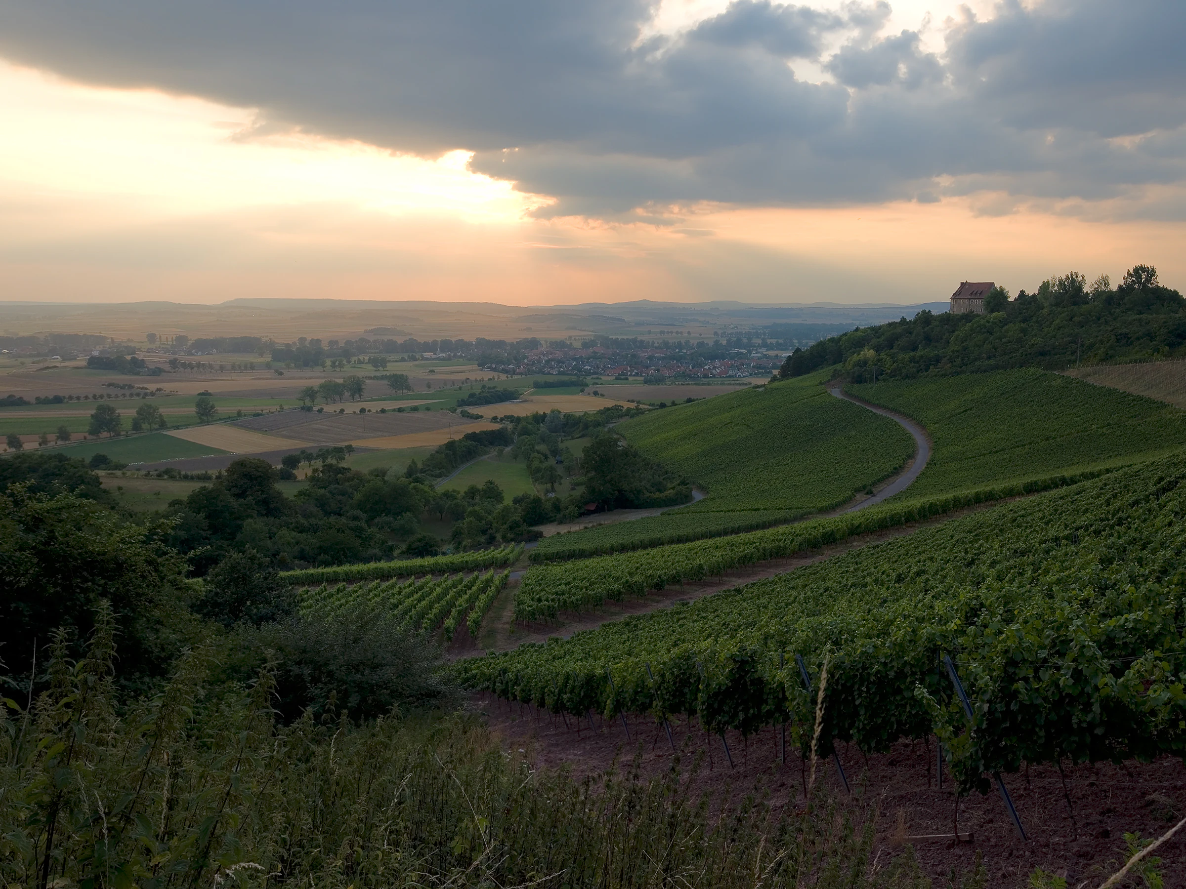
A wide-angle sunset view overlooking rolling green vineyard slopes with a small castle structure visible on a distant hilltop.
Sunset over the vineyards near Burg Hoheneck in Naturpark Frankenhöhe.

Naturpark Frankenhöhe history and protected-area timeline

Naturpark Frankenhöhe was designated as a state-recognized nature park in Bavaria in 1974. Its establishment built on a long tradition of regional efforts to protect the cultural and natural landscape of the Frankenhöhe hill ridge and surrounding Franconian countryside.

The park was created around the core area of the Frankenhöhe, extending eastward into much of the Rangau and reaching toward long-standing district boundaries and rural municipalities that anchor the area socially and economically. The administrative setup now relies on Naturpark Frankenhöhe e. V., an association that coordinates the park's management, regional development, and recreational programming.

Over time, the park's protection framework has expanded beyond the nature park designation itself. A large portion of its area is now classified as a landscape protection area, and several smaller nature reserves have been established within the park or adjacent to it, strengthening the conservation value of the protected landscape.

Naturpark Frankenhöhe landscape and geographic character

The landscape of Naturpark Frankenhöhe is shaped by two contrasting yet complementary physical systems. In the west and north, the Frankenhöhe hill ridge forms a wooded backbone, with forested peaks rising above 500 meters and slopes that in places drop sharply toward neighboring lowlands. In the east, the more open terrain of the Rangau unfolds as a gently rolling agricultural landscape punctuated by villages, small valleys, and historic estates.

To the northwest, the Frankenhöhe falls toward the Windsheimer Bucht, while to the far west the land drops toward the Hohenloher Ebene and the Tauber valley. These transitions give the park a strongly varied relief in a relatively small area, alternating between higher forested ridges and deeper, often narrow river valleys that cut into the surrounding uplands.

Hydrologically, the park sits along the European Main Watershed. The Wörnitz, Sulzach, and Altmühl rivers run roughly north to south through the southern section of the park, carrying water toward the Danube. In contrast, the Fränkische Rezat, Bibert, Zenn, and Aurach rise on the Frankenhöhe but flow westward or eastward into the Regnitz system, ultimately reaching the Main and Rhine. This dual drainage pattern is central to the park's geographic identity and is reflected in its hiking themes.

About one third of the park is forested, with wooded crests giving way to clearly defined valleys and open farmland. On the slopes of both the Frankenhöhe and the Rangau, traditional orchard meadows, locally known as Streuobstwiesen, frame the agricultural land, and isolated vineyard stands add further variation to the visual character of the countryside.

Naturpark Frankenhöhe ecosystems, habitats, and plant life

Naturpark Frankenhöhe protects a notably diverse mosaic of habitats for a southern German nature park. Forest covers roughly a third of the area, with woodland on the hill ridges giving way to open valleys, agricultural land, and culturally shaped semi-natural habitats.

Dry biotopes are a particularly important feature of the park. The dry, sunny conditions on parts of the Frankenhöhe and within the Rangau support species-rich dry grasslands and grazed open habitats that are rare elsewhere in the region. These areas host specialized plant communities and provide habitat for invertebrates and birds that depend on warm, open terrain.

Traditional orchard meadows, known as Streuobstwiesen, line many of the slopes. These old fruit-tree meadows are an important element of the park's ecological identity, supporting a wide range of species including pollinators, woodland birds, and small mammals, while also preserving traditional Franconian land use.

The river valleys that cut through the park add aquatic and wetland habitats alongside the dry uplands. Streams such as the Wörnitz, Altmühl, Fränkische Rezat, Bibert, Zenn, and Aurach create corridors of riparian vegetation through the broader agricultural and forested matrix. The combination of dry slopes, forest, orchards, vineyards, and river valleys gives the park a layered ecological character that reflects both its climate and its long history of human management.

Naturpark Frankenhöhe wildlife and species highlights

The varied habitats of Naturpark Frankenhöhe support a broad range of wildlife typical of central Franconia. The mosaic of mixed forest, dry grasslands, orchard meadows, and river valleys provides niches for forest species, open-country species, and freshwater wildlife within a relatively compact area.

The wooded ridges of the Frankenhöhe host typical central European forest fauna, while the dry open areas and grazed slopes provide habitat for birds and insects adapted to warm, sun-exposed terrain. The traditional Streuobstwiesen are particularly important for orchard-associated species, including a wide variety of insects, cavity-nesting birds, and bats. The region's protected nature reserves, such as the Vogelfreistätte Großer und Kleiner Lindleinsee, add further significance for birdlife, while lake and pond reserves contribute to wetland and aquatic habitat values.

Rivers flowing through the park support freshwater fauna, including typical fish species of central Franconian streams. The combination of forest, dry open ground, orchard meadows, vineyards, and watercourses gives the park significant ecological continuity and supports a healthy network of wildlife corridors across the region.

Naturpark Frankenhöhe conservation status and protection priorities

Naturpark Frankenhöhe plays an important role in the conservation of central Franconian cultural and natural landscapes. Its designation as a nature park combines protection of the region's character with active support for sustainable regional development under the management of Naturpark Frankenhöhe e. V.

A large share of the park is also formally protected as a landscape protection area, reinforcing the conservation status of woodland, dry habitats, agricultural land, and river valleys. Within and adjacent to the park, several nature reserves add stronger protection to specific sites of high ecological value, including dry grassland reserves, lake and pond reserves, cave features, and areas designated for bird protection. These protected zones safeguard elements of the regional flora, fauna, and geological heritage that might otherwise be vulnerable to changes in land use.

By integrating large protected landscapes with smaller high-value reserves, the park contributes to a network of conservation areas across Middle Franconia. In the northeast, it connects to Naturpark Steigerwald, helping strengthen ecological and recreational continuity across the broader region.

Naturpark Frankenhöhe cultural meaning and human context

The cultural landscape of Naturpark Frankenhöhe reflects centuries of Franconian rural tradition. The orchard meadows, vineyards, villages, and small market towns scattered throughout the area carry strong regional identity and are closely tied to the park's agricultural economy and visual character.

Historic towns on or near the park's edges, including Rothenburg ob der Tauber, Ansbach, Feuchtwangen, Schillingsfürst, Bad Windsheim, and Neustadt an der Aisch, anchor the park within a wider network of Franconian cultural heritage. Walking routes such as the Fränkischer Jakobsweg and the Frankenhöhe-Weg link these towns through long-established pilgrimage and regional trails.

Traditional land uses, including orchard meadow management, dry grassland grazing, and small-scale viticulture, remain visible across the park. These practices sustain both the local economy and the cultural landscape that makes the park distinctive.

Top sights and standout views in Naturpark Frankenhöhe

Standout features of Naturpark Frankenhöhe include its position along the European Main Watershed, its unusually sunny southern German climate that supports dry habitats and vineyards, and its combination of mixed forest, orchard meadows, and pronounced river valleys. The park's overlap with the broader Frankenhöhe hill ridge and the western Rangau gives it a layered geography in which higher, forested uplands meet open agricultural lowlands within a compact area.

Key nature reserves such as the Vogelfreistätte Großer und Kleiner Lindleinsee and protected lake, cave, and dry grassland sites deepen the park's conservation profile. Long-distance walking and cycling routes, including the Frankenhöhe-Weg, the European Watershed trail, and regional pilgrimage paths, make the park accessible for visitors interested in cultural history, regional landscape, and outdoor recreation.

Best time to visit Naturpark Frankenhöhe

Naturpark Frankenhöhe has a notably sunny climate for southern Germany, and the warmer months typically bring the most vivid experience of its dry habitats, orchard meadows, and vineyard slopes. Late spring and summer are particularly good for viewing the full character of the open countryside, with flowering orchard meadows and active wildlife in dry grasslands and field margins.

Autumn is appealing for the forested ridges of the Frankenhöhe, when mixed woodland colors contrast with the surrounding agricultural lowlands and villages. Winter can offer quieter, atmospheric views of the hill ridges and valleys, though conditions may affect accessibility for some walking routes. Across the year, the park's combination of forested uplands and sunlit valleys gives it varied seasonal character.

Monthly climate preview

Long-term representative point measurements and monthly averages for Naturpark Frankenhöhe

Naturpark Frankenhöhe Climate Normals, Annual Temperature and Precipitation Rhythm

Naturpark Frankenhöhe exhibits measured long-term temperature swings alongside steady daily precipitation rates across all twelve sample periods. Reviewing the complete monthly climate normals reveals detailed shifts in average minimum and maximum thresholds for the protected area.
Annual mean9 °C
-1 °C19 °C
Jan-1°
Feb
Mar
Apr
May13°
Jun17°
Jul19°
Aug19°
Sep14°
Oct
Nov
Dec
Warmest month
July

19.2 °C

Coolest month
January

-1.1 °C

Wettest month
July

2.6 mm/day

Driest month
April

1.4 mm/day

Park location guide

Geography guide, regional context, and park location map for Naturpark Frankenhöhe

Naturpark Frankenhöhe park geography, regions, and map view in Germany

Understand where Naturpark Frankenhöhe sits in Germany through a broader geographic reading of the surrounding landscape, nearby location context, and its mapped position within the national park landscape.

How Naturpark Frankenhöhe fits into Germany

Germany is a federal republic in Western and Central Europe with a population of over 83 million across sixteen constituent states. It is Europe's largest economy by nominal GDP and a major global exporter and importer. The capital is Berlin, and the country borders Denmark, Poland, Czech Republic, Austria, Switzerland, France, Luxembourg, Belgium, and the Netherlands.

Wider geography shaping Naturpark Frankenhöhe in Germany

Germany is located in Western and Central Europe, spanning 357,022 km². It borders Denmark to the north, Poland and the Czech Republic to the east, Austria and Switzerland to the south, and France, Luxembourg, Belgium, and the Netherlands to the west. The country has coastlines on the Baltic Sea and North Sea to the north, with the Alps located in the southern region.

Map view of Naturpark Frankenhöhe

Use this park location map to pinpoint Naturpark Frankenhöhe in Germany, understand its exact geographic position, and read its mapped placement within the surrounding landscape more clearly.

Pigeon | © OpenStreetMap contributors

Location context for Naturpark Frankenhöhe

BayernMittelfranken
Recorded earthquake history

Review the Historical Earthquake Catalogue for Naturpark Frankenhöhe

Examine the historical record of seismic events associated with the geography of Naturpark Frankenhöhe. This MoriAtlas dataset organizes recorded earthquake activity, helping users analyze regional seismic patterns through transparent event data and precise location mapping.

Naturpark Frankenhöhe Earthquake Records

Catalogued events

2 events

Strongest magnitude

Magnitude 3

Most recent event

Feb 14, 1996

This history includes earthquakes recorded inside the park or within 50 km of its borders

Examine wooded hill ridges, sunny vineyard slopes, and protected valley habitats.

Naturpark Frankenhöhe Photos and Landscapes: Visual Exploration of Scenery

Visual documentation reveals the varied terrain and protected habitats defining Naturpark Frankenhöhe. Photographic records illustrate wooded crests, river valleys, and traditional orchard meadows across the Franconian landscape.

A wide-angle sunset view overlooking rolling green vineyard slopes with a small castle structure visible on a distant hilltop.

A gently sloping meadow dotted with various scattered fruit trees, with a forested hillside in the background under soft daylight.

Park atlas

Compare regional geography, forested ridges, and adjacent conservation areas

Explore Other Parks Near Naturpark Frankenhöhe and Surrounding Protected Landscapes

Browsing other parks near Naturpark Frankenhöhe reveals the broader protected landscapes and river valleys defining western Middle Franconia. Expanding the geographic scope allows travelers to compare adjacent nature reserves, hill ridges, and regional habitats across Bavaria.
A horizontal watercolor illustration depicting a soft, pastel landscape with rolling hills in the background, a small pond, and several green and light pink flowering trees.
Nature reserveBaden-Württemberg
0 km away#1 closest

Southwest

Crailsheimer Hart und Reusenberg: Protected Nature Reserve and Karst Landscape Geography

Jagst valley protected habitat in Baden-Württemberg

Crailsheimer Hart und Reusenberg represents a key conservation unit in southwest Germany. This nature reserve is recognized for its distinctive gypsum keuper geology, which creates a network of dolines, semi-dry grasslands, and near-natural floodplain forests. Understanding its boundaries provides insight into habitat connectivity within the broader Baden-Württemberg protected-area network.

Area
7.14 km²
Established
2019
Watercolor painting of a river winding through a gentle green valley with distant hills.
Nature reserveBaden-Württemberg
5 km away#2 closest

Southwest

Jagst bei Kirchberg und Brettach Nature Reserve: Protected River Landscapes of Baden-Württemberg

River valleys, calcareous grasslands, and limestone terrain in Southwestern Germany.

The Jagst bei Kirchberg und Brettach nature reserve preserves a diverse corridor of natural river meanders, floodplain meadows, and beech forests. Situated in the Baden-Württemberg region, this protected area spans nearly 900 hectares, offering a rich study in limestone geology and riparian ecology within the Kocher-Jagst plains.

Area
8.93 km²
Established
2019
Relief
Upland
Climate
Temperate
A wide watercolor illustration showing a landscape of rolling green hills and trees under a pastel pink and yellow sky.
Protected landscapeGermany
About 10 km away#3 closest

West

Niederstetten (Landschaftsschutzgebiet) Protected Landscape Map and Regional Terrain Data

Protected landscape and topographic features in Baden-Württemberg

Covering 1,786 hectares, the Niederstetten (Landschaftsschutzgebiet) serves as a vital protected landscape within the Hohenlohe region. It is recognized for its deeply incised side valleys, stream-fed corridors, and traditional dry-stone wall boundaries that define this portion of the German countryside.

Area
17.86 km²
Established
1992
Relief
Upland
Climate
Temperate
Protected landscapeBaden-Württemberg
About 12 km away#4 closest

West

Weikersheim Protected Landscape: Mapping the Tauberland Terrain in Baden-Württemberg

Historic stone ridges and forested Klingen valleys.

Encompassing a wide stretch of the Tauberland, the Weikersheim Protected Landscape represents a significant conservation effort in Baden-Württemberg. The territory features a varied patchwork of slopes, meadows, and woodlands, anchored by rare dry-stone ridge formations that trace the historic patterns of regional agriculture. Examine the geographic boundaries and habitat distribution within this extensive protected landscape zone.

Area
27.18 km²
Established
1993
IUCN
V
Scope
Terrestrial
A soft watercolor painting of a river valley with green fields, distant hills, and a prominent tree in the foreground on the right.
Protected areaBaden-Württemberg
13 km away#5 closest

Southwest

Bühlertal Vellberg-Geislingen: Protected River Valley and Karst Geography

A concentrated habitat corridor in Baden-Württemberg

This protected area follows the Bühler river through a series of tight meanders and dramatic limestone formations. The landscape is characterized by a transition from wet floodplain woods and tall-herb fringes to dry calcareous grasslands and hillside forests. Covering over 800 hectares, the site serves as a vital ecological link across the Kocher-Jagst plains and the forested ridges of the Schwäbisch-Fränkische Waldberge.

Area
8.474 km²
Established
2019
Relief
Upland
Climate
Temperate
A soft watercolor painting of a calm reservoir surrounded by light green trees and low vegetation.
Protected landscapeBaden-Wuerttemberg
About 18 km away#6 closest

Southwest

Speicherbecken Orrot: Geography and Protected Landscape Analysis in Baden-Wuerttemberg

Reservoir, valley terrain, and wetland mapping

Speicherbecken Orrot serves as a significant example of a protected valley landscape within the Ostalbkreis. The area centers on the Orrotsee reservoir, surrounded by a mosaic of fish ponds, wet meadows, and forested slopes. Our mapping provides a clear view of the park boundaries and the ecological features that distinguish this wetland geography from the surrounding upland terrain.

Area
0.567 km²
Established
1968
IUCN
V
A watercolor painting showing a panoramic landscape with light green hills, tall slender trees in the foreground, and soft washes of color depicting a natural forest scene.
Nature reserveBavaria
About 19 km away#7 closest

North

Naturwald Schlag Nature Reserve: Geographic Atlas and Protected Forest Context in Bavaria

A dedicated site for natural forest development and regional conservation mapping

Naturwald Schlag serves as a vital case study for non-intervention forestry in the Steigerwald region of Upper Franconia. Located near the locality of Heuchelheim, this reserve protects a mature stand of pine, beech, and oak. MoriAtlas provides a clear view of its formal designation and geographic position within the broader Bavarian natural forest network.

Area
0.008 km²
Established
2021
Relief
Upland
Climate
Temperate
A horizontal watercolor illustration of a natural landscape showing sandy ground, patches of green vegetation, a small pond, and a distant treeline against a pale sky.
Nature reserveNuremberg
About 22 km away#8 closest

East

Sandgruben am Föhrenbuck Nature Reserve: Geography and Protected Area Overview in Nuremberg

A compact mosaic of restored quarry habitats and forest terrain in Bavaria.

Sandgruben am Föhrenbuck stands as a notable protected area in Nuremberg, Germany, defined by its dense concentration of varied ecosystems including wetlands, dry heath, and open sand. This former industrial site demonstrates how active management can foster diverse habitats, providing a rich area for studying land restoration and regional biodiversity within a forest-framed setting.

Area
0.219 km²
Established
1992
IUCN
IV

Common questions about visiting, size, designation, and location context for Naturpark Frankenhöhe

Naturpark Frankenhöhe FAQs for park facts, access, geography, and protected area context

Find quick answers about Naturpark Frankenhöhe, including protected-area facts, park geography, trail and visitor context, and how the park fits into its surrounding country and regional landscape.
MoriAtlas Explorer

Continue Your Protected Areas Search Across the Global Atlas

Deepen your exploration by continuing the structured search for national parks and protected areas worldwide. Utilize the comprehensive filtering capabilities to compare different conservation landscapes and refine your understanding of global park geography. Discover more about the distribution and characteristics of protected natural areas.

Global natural geography