

Mori Atlas logo
Protected landscapeNaturpark Fränkische Schweiz – Frankenjura

A detailed look at the dolomite ridges, river valleys, and vast forested plateaus of the Franconian Jura.

Naturpark Fränkische Schweiz – Frankenjura: Mapping the Karst Geography of Northern Bavaria

Naturpark Fränkische Schweiz – Frankenjura represents one of the largest protected landscapes in northern Bavaria. This extensive region encompasses the Nördliche Frankenalb, where deeply cut river valleys meet broad karst plateaux and dramatic dolomite outcrops. The territory serves as a vital geographic anchor, integrating diverse karst phenomena, historic castle ruins, and the expansive woodland of the Veldensteiner Forst into a coherent protected landscape.

karst landscaperiver valleysdolomite formationscavescastle ruinspine forest

Naturpark Fränkische Schweiz – Frankenjura

Protected landscape

Park overview

Structured park overview, official facts, and landscape profile for Naturpark Fränkische Schweiz, Frankenjura

Naturpark Fränkische Schweiz, Frankenjura park facts, protected area profile, and essential visitor context

Review the core facts for Naturpark Fränkische Schweiz, Frankenjura, including designation, size, terrain, visitor scale, habitats, and operating context in one park-focused overview.

About Naturpark Fränkische Schweiz, Frankenjura

Naturpark Fränkische Schweiz – Frankenjura represents one of the most iconic protected natural landscapes of northern Bavaria and encompasses the heart of the Franconian Jura. At well over 2,300 square kilometers, it is the second-largest nature park in Bavaria, positioned only behind the Naturpark Altmühltal, and it almost completely matches the boundaries of the Nördliche Frankenalb, the natural region of the northern Franconian Alb.

The park's core is the Fränkische Schweiz, a landscape shaped by millions of years of karst processes. Deeply eroded valleys, such as the Wiesenttal visible from the ruins of Burg Neideck, cut into broad, uplifted limestone plateaux and reveal dramatic cliffs, solitary rock towers, and dolomite formations. The geology has produced a subterranean world of caves and sinkholes, and on the surface it has created the kind of varied, rocky terrain that hosts juniper slopes, dry grasslands, mixed deciduous forests, and patches of near-mountainous relief on the high plateaus.

In the eastern portion of the park, the Veldensteiner Forst provides a sharp contrast with its broad, closed pine forest, managed traditionally for wildlife and forest productivity, and known for hosting substantial populations of red deer. Together, the Fränkische Schweiz and the Veldensteiner Forst form the dual cultural-ecological identity of the park: a romantic, castle-studded karst country in the west and a quiet, forested wilderness in the east.

The park is also recognized for how tightly human history is woven into its natural setting. Castles, ruined fortifications, and small old towns dot the landscape, and the centuries-old human relationship with this terrain has shaped both its appearance and its current protection status. In 1995, the area gained its official designation as a Naturpark through a formal ordinance, codifying decades of conservation work and regional identity that started with the founding of the park's supporting association in 1968.

Quick facts and research context for Naturpark Fränkische Schweiz, Frankenjura

Naturpark Fränkische Schweiz – Frankenjura lies in northern Bavaria and was established in 1968, with its present boundaries formally set by a 1995 ordinance and the park covering roughly 2,335 square kilometers. It corresponds closely to the natural region known as the Nördliche Frankenalb, the northern portion of the Franconian Jura, and is managed by the Verein Naturpark Fränkische Schweiz – Frankenjura e.V., headquartered in Pottenstein.

The park spans parts of three Bavarian administrative regions, Upper Franconia (Oberfranken), Middle Franconia (Mittelfranken), and the Upper Palatinate (Oberpfalz), and includes major portions of the Landkreis Bayreuth along with parts of Bamberg, Forchheim, Kulmbach, Lichtenfels, Nürnberger Land, Amberg-Sulzbach, and Neustadt an der Waldnaab. It is the second-largest nature park in Bavaria, surpassed only by the Naturpark Altmühltal.

Protection and recognition

Terrestrial conservation framework, designation year, and management history records

Naturpark Fränkische Schweiz – Frankenjura Protection Status and Designation Facts

Naturpark Fränkische Schweiz – Frankenjura maintains a documented terrestrial protection status established in 1995. Structured records outline the official designation history and management scope associated with this protected area.

Protection details

Protection scope
Terrestrial
Designated year
1995
Transboundary protection
No
Park context

Deeper park guide and search-rich context for Naturpark Fränkische Schweiz, Frankenjura

Naturpark Fränkische Schweiz, Frankenjura history, landscape, wildlife, and travel context

Explore Naturpark Fränkische Schweiz, Frankenjura through its history, landscape character, ecosystems, wildlife, conservation priorities, cultural context, and seasonal travel timing in a structured park guide built for atlas discovery and search intent.

Why Naturpark Fränkische Schweiz, Frankenjura stands out

The park is best known for the romantic, deeply incised river valleys of the Fränkische Schweiz, where rocky cliffs, dolomite outcrops, and wooded slopes frame narrow floodplains and dramatic gorges. Visitors and travelers have long associated this landscape with the picturesque combination of karst formations, cave systems, and the castles that crown so many of its hilltops. Equally characteristic is the Veldensteiner Forst, a large, contiguous pine-dominated forest in the eastern part of the park that is known for its red deer population and its quiet, remote character. Together, the Dolomitkuppenalb, the Hersbrucker Alb, and the northern Oberpfälzer Jura extend the park's geological and ecological variety, giving the nature park a richness of habitat and visual landscape that is unusual within Bavaria.
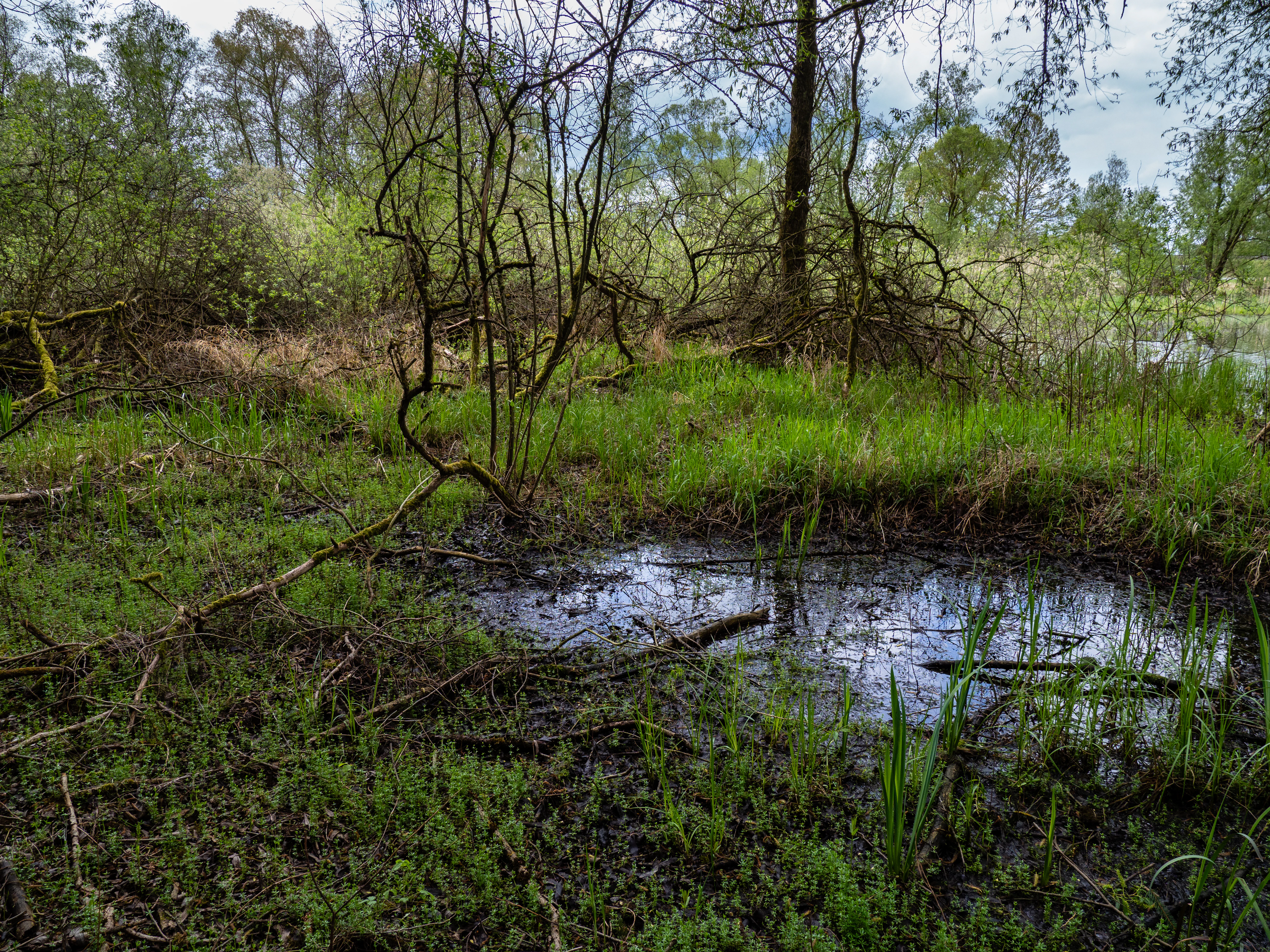
Gaabsweiher Pond
Gaabsweiher nature reserve near Lichtenfels

Naturpark Fränkische Schweiz, Frankenjura history and protected-area timeline

The nature park was founded in 1968 with the establishment of the Verein Naturpark Fränkische Schweiz – Frankenjura e.V., headquartered in Pottenstein. The supporting association has remained the institutional backbone of the park, coordinating protection, regional development, and interpretive work for the broader Franconian Switzerland area.

Its modern boundaries were formally established in 1995, when, on July 14, the park was officially designated by ordinance as a Naturpark, taking effect on September 1 of that year. This 1995 designation codified the geography that the park continues to operate within today, covering an envelope slightly larger than, but broadly coinciding with, the natural region of the Nördliche Frankenalb.

In 2018, the park took on its present-day name. Until that year, it had been officially known as Naturpark Fränkische Schweiz – Veldensteiner Forst, a designation that highlighted the park's two major landscape components: the karst-and-valley country of the Fränkische Schweiz and the large continuous forest of the Veldensteiner Forst. The renaming to Fränkische Schweiz – Frankenjura reflects a broader regional identity, aligning the protected area more firmly with the wider concept of the Frankenjura, the Franconian portion of the Jura massif.

Naturpark Fränkische Schweiz, Frankenjura landscape and geographic character

The landscape of the park is one of the most visually distinctive in Germany, characterized by a karst highland dissected by deeply incised valleys. Across the Fränkische Schweiz, broad limestone and dolomite plateaux, known as the Frankenalb, are cut by narrow, winding rivers, creating dramatic gorges and river valleys with steep rock walls that rise above the floodplains. The terrain alternates between elevated, relatively flat tablelands and sharply cut valleys below, producing a constantly changing visual rhythm of cliff, slope, and meadow.

Solitary rock outcrops, dolomite formations, and hidden cave entrances punctuate the otherwise forested slopes. The region is famous for its karst phenomena, which include caves typical of the Franconian Jura and dolomite cupola formations that give some ridges an unusual, almost mountainous appearance despite the modest elevations. Exposed rocky outcrops have created habitats for juniper slopes, dry grasslands, and warm, sheltered rock communities, all of which coexist within broader forest cover.

In the east, the Veldensteiner Forst introduces a markedly different visual character: a single, large forest block dominated by pine trees, with longer sightlines, fewer dramatic cliffs, and a more contemplative atmosphere. This forested highland provides the park with interior, quieter country and supports the traditional association of the eastern portion of the park with wilderness character and rich wildlife.

The Hersbrucker Alb and the northern reaches of the Oberpfälzer Jura extend the park's landscape variety eastward, contributing cooler upland forests and additional karst elements. The Dolomitkuppenalb, a sub-region of the Franconian Alb known for its dome-shaped dolomite forms, contributes another visually striking layer to the park's terrain palette.

Naturpark Fränkische Schweiz, Frankenjura ecosystems, habitats, and plant life

The nature park sits within the northern section of the Franconian Jura, a karst landscape that supports a remarkable mosaic of habitats on a relatively compact geographic scale. Limestone and dolomite bedrock give rise to thin, well-draining soils that support juniper heaths, dry grasslands, and warm-loving forest communities, especially on south-facing rock slopes. The same geology produces karst phenomena underground, with caves and subterranean drainage systems shaping how water and vegetation are distributed on the surface.

Mixed deciduous forests cloak many of the slopes and valley margins, with beech, oak, and other broadleaf species typical of central European uplands. The Veldensteiner Forst in the east is more conifer-dominated, with extensive pine stands that lend the eastern park a distinct northern-boreal feel and provide habitat for forest game, particularly red deer. Across the mosaic, meadows and pastures along valley floors contribute to the agricultural-cultural landscape that has long defined the Fränkische Schweiz.

Within the park, a substantial network of nature reserves and landscape protection areas (Naturschutzgebiete and Landschaftsschutzgebiete) reinforces conservation of these habitats. Notable protected sites include Pegnitzau between Ranna and Michelfeld, the Ehrenbürg hill, the Staffelberg, juniper slopes near Wonsees, Kleinziegenfeld, and Wallersberg, dry slopes around Pottenstein, mixed deciduous forests on the Hetzleser Berg and in the upper Aufseßtal, forest reserves at the Eibenwald near Gößweinstein and in the Lohntal, and protected wetland systems such as the Gaabsweiher and Craimoosweiher.

Naturpark Fränkische Schweiz, Frankenjura wildlife and species highlights

The park's long-standing association with the red deer of the Veldensteiner Forst is its most recognizable wildlife feature. This forested highland has supported red deer for centuries and remains one of the most important strongholds of red deer in northern Bavaria, shaping the traditional image of the eastern portion of the park as quiet, forested, and animal-rich.

Beyond red deer, the mosaic of forests, rocky cliffs, dry grasslands, and small wetland habitats supports a varied central European fauna typical of the Franconian Jura. Forest wildlife includes typical species of mixed and coniferous woodland, while the open and dry habitats along river valleys and rocky slopes provide homes for fauna adapted to warmer, more exposed conditions, characteristic of the juniper slopes and dry grasslands of the region.

Wetland wildlife is concentrated in scattered protected ponds and wet meadows, including sites such as the Gaabsweiher and Craimoosweiher, while rivers like the Pegnitz, the Wiesent, and the Aufseß sustain aquatic and riparian communities within narrow valley corridors. The cave systems of the karst landscape host their own specialized fauna, contributing an often overlooked but ecologically distinctive element to the park's wildlife profile.

Naturpark Fränkische Schweiz, Frankenjura conservation status and protection priorities

The conservation significance of the park is rooted in its preservation of a continuous stretch of the Nördliche Frankenalb, a karst landscape under high pressure from agriculture, forestry, tourism, and historical land use. Designation as a Naturpark in 1995, building on the founding of the supporting association in 1968, established an institutional framework for balancing protection of natural and cultural heritage with regional development and outdoor recreation.

The park incorporates a notable network of formal nature reserves, including the Pegnitzau nature reserve between Ranna and Michelfeld, the Ehrenbürg, the Staffelberg, the dry slopes around Pottenstein, juniper-rich slopes near Kleinziegenfeld, Wallersberg, and Wonsees, the mixed deciduous forest reserves on the Hetzleser Berg and in the upper Aufseßtal, the Eibenwald forest reserve near Gößweinstein, the Lohntal reserve, and several wetland sites including the Craimoosweiher and the Gaabsweiher. Landscape protection areas layer additional, broader-scale protection across much of the park's territory.

The cave and karst systems of the park are themselves objects of geoconservation, both for their scientific importance and for their role in supporting specialized subterranean communities. By linking legislative reserves, traditional forest management, and regional identity around the Fränkische Schweiz and the Veldensteiner Forst, the park has established itself as a major node in Bavaria's protected-area network, second only to the Naturpark Altmühltal in size within the state.

Naturpark Fränkische Schweiz, Frankenjura cultural meaning and human context

The Fränkische Schweiz carries a long-standing cultural identity as one of the romantic heartlands of Franconia. Its dense network of castles, often perched on cliffs above river valleys, reflects the medieval political fragmentation of the region and has become inseparable from how the landscape is perceived. Sites such as the Burgruine Neideck above the Wiesenttal have become emblematic of the visual combination of rock, valley, and ruin that defines the area in Franconian cultural imagination.

The Veldensteiner Forst, by contrast, embodies a quieter, more forested cultural heritage, associated with traditional forestry, hunting traditions, and the wilderness character that has long shaped regional identity on the eastern side of the park. Across the broader area, small towns, pilgrimage sites, and centuries-old rural land use have all contributed to a deeply layered relationship between the people of northern Bavaria and this landscape. The park's existence, founded through a citizens' association in 1968, reflects how strongly local communities and regional identity have been intertwined with the management of this territory.

Top sights and standout views in Naturpark Fränkische Schweiz, Frankenjura

Among the park's strongest features are the deeply cut karst valleys of the Fränkische Schweiz, the dramatic dolomite and limestone cliffs that frame rivers like the Wiesent, the dense pattern of medieval castles and ruins crowning so many of its hilltops, and the iconic caves and karst phenomena hidden within the Franconian Alb. The Veldensteiner Forst adds a wholly different, quieter counterpoint: a vast, unbroken pine forest with traditional red deer populations and remote woodland atmosphere.

In addition, the park's layered conservation framework, encompassing the Pegnitzau nature reserve, the Ehrenbürg, the Staffelberg, juniper-rich slopes, and the Eibenwald forest reserve, gives it strong ecological depth. Combined with its size as Bavaria's second-largest nature park and its location at the meeting point of three Bavarian administrative regions, the park offers both scenic variety and significant habitat diversity within a single protected landscape.

Best time to visit Naturpark Fränkische Schweiz, Frankenjura

The nature park's scenery shifts substantially across the year and rewards visits at multiple points in the seasonal cycle. Late spring and early summer tend to be especially attractive in the river valleys, where fresh green foliage softens the karst cliffs and meadows come into bloom, while also offering comfortable conditions for exploring the outdoor landscape. Autumn brings strong color to the mixed deciduous forests of the Fränkische Schweiz and a quieter, contemplative atmosphere across the Veldensteiner Forst, and can be a rewarding time for those drawn to forest character and longer hiking.

Winter visits bring out a different identity altogether, with snow occasionally highlighting the rocky outcrops, ridges, and castle ruins of the karst country, though conditions can vary significantly across the park's terrain. The eastern forested portion of the park generally remains quieter year-round and is well suited to visitors looking for solitude and forest atmosphere, while the western valley landscapes tend to draw most visitors during the milder months when outdoor recreation peaks.

Monthly climate preview

Long-term representative temperature and precipitation rhythm across twelve recorded months.

Naturpark Fränkische Schweiz – Frankenjura Annual Climate Normals

Representative coordinates record measured monthly temperature and precipitation values that track the annual climate rhythm of Naturpark Fränkische Schweiz – Frankenjura from 1991 to 2020. Opening the complete monthly climate profile reveals detailed twelve-month temperature averages and precipitation totals for deeper analysis.
Annual mean8 °C
-2 °C19 °C
Jan-2°
Feb-1°
Mar
Apr
May13°
Jun16°
Jul19°
Aug19°
Sep14°
Oct
Nov
Dec-1°
Warmest month
July

18.7 °C

Coolest month
January

-1.9 °C

Wettest month
July

2.7 mm/day

Driest month
April

1.4 mm/day

Park location guide

Geography guide, regional context, and park location map for Naturpark Fränkische Schweiz, Frankenjura

Naturpark Fränkische Schweiz, Frankenjura park geography, regions, and map view in Germany

Understand where Naturpark Fränkische Schweiz, Frankenjura sits in Germany through a broader geographic reading of the surrounding landscape, nearby location context, and its mapped position within the national park landscape.

How Naturpark Fränkische Schweiz, Frankenjura fits into Germany

Germany is a federal republic in Western and Central Europe with a population of over 83 million across sixteen constituent states. It is Europe's largest economy by nominal GDP and a major global exporter and importer. The capital is Berlin, and the country borders Denmark, Poland, Czech Republic, Austria, Switzerland, France, Luxembourg, Belgium, and the Netherlands.

Wider geography shaping Naturpark Fränkische Schweiz, Frankenjura in Germany

Germany is located in Western and Central Europe, spanning 357,022 km². It borders Denmark to the north, Poland and the Czech Republic to the east, Austria and Switzerland to the south, and France, Luxembourg, Belgium, and the Netherlands to the west. The country has coastlines on the Baltic Sea and North Sea to the north, with the Alps located in the southern region.

Map view of Naturpark Fränkische Schweiz, Frankenjura

Use this park location map to pinpoint Naturpark Fränkische Schweiz, Frankenjura in Germany, understand its exact geographic position, and read its mapped placement within the surrounding landscape more clearly.

Pigeon | © OpenStreetMap contributors

Location context for Naturpark Fränkische Schweiz, Frankenjura

Bavaria
Recorded earthquake history

Explore Historical Earthquake Records for Naturpark Fränkische Schweiz – Frankenjura

Examine documented seismic events associated with this Bavarian nature park. Review the historical catalogue to understand past activity through event dates, magnitudes, and proximity, as catalogued in the MoriAtlas regional seismic database.

Naturpark Fränkische Schweiz – Frankenjura Earthquake History

Catalogued events

3 events

Strongest magnitude

Magnitude 3.2

Most recent event

Mar 23, 2005

This history includes earthquakes recorded inside the park or within 50 km of its borders

Visual reference of karst terrain, river gorges, and protected woodlands.

Naturpark Fränkische Schweiz – Frankenjura Photos and Scenic Landscapes

Visual documentation captures the dramatic karst topography, deeply incised river valleys, and prominent dolomite rock formations defining Naturpark Fränkische Schweiz – Frankenjura. Examining field imagery reveals the distinct ecological character of its limestone plateaux, cave networks, and dense pine forests.

Gaabsweiher Pond

Park atlas

Compare surrounding regional geography and connected protected areas across northern Bavaria

Parks Near Naturpark Fränkische Schweiz – Frankenjura and Protected Landscapes

Browse other protected areas near Naturpark Fränkische Schweiz – Frankenjura to examine adjacent karst highlands and river valleys. Expanding the geographic comparison reveals broader regional conservation patterns and connected Bavarian landscapes.
Protected landscapeBavaria
Park boundaries overlap#1 closest

East

Naturpark Nördlicher Oberpfälzer Wald: Protected Landscape and Regional Geography Map

Forested upland terrain and volcanic geology in Bavaria

Explore the structured geography of Naturpark Nördlicher Oberpfälzer Wald, a massive protected region in Bavaria. This detailed profile highlights the park's characteristic ridge and valley terrain, volcanic basalt landmarks, and its role as a vital ecological belt along the international border.

Area
1,380 km²
Water
Minor water
Nature reserveBavaria
Mapped location lies within the park boundary#2 closest

Northwest

Naturwald Vierzehnheiligen Protected Area and Bavarian Forest Geography

Nature reserve featuring old-growth deciduous stands and limestone slope terrain

Naturwald Vierzehnheiligen comprises a vast, strictly protected forest in Upper Franconia, Germany. Spanning the foothills of the northern Franconian Jura, this reserve is defined by its structurally diverse canopy, moist ravine habitats, and limestone geological formations. It provides a essential study in non-intervention woodland management, serving as a critical refuge for broadleaved-forest species within the regional Bavarian landscape.

Area
5.413 km²
Established
2020
Relief
Upland
Climate
Temperate
Nature reserveBavaria
Mapped location lies within the park boundary#3 closest

Southeast

Schergenbuck mit Schloss Neidstein: Nature Reserve and Protected Karst Landscape

Forestry and geological mapping of a historic Bavarian ridge

Located in the Amberg-Sulzbach district of Bavaria, this nature reserve integrates historic castle ruins with species-rich deciduous woodland and sensitive karst topography. It remains a key point of interest for understanding how small-scale protected areas preserve biodiversity, including native European yew, against the backdrop of the Franconian Jura landscape.

Area
0.177 km²
Established
1973
IUCN
IV
Relief
Upland
Nature reserveBavaria
About 3.8 km away#4 closest

South

Schottental bei Heldmannsberg Nature Reserve: Mapped Geography and Protected Valley Landscapes

A diverse karst valley reserve in the Middle Franconia region of Bavaria.

Located in the Nürnberger Land district of Bavaria, Schottental bei Heldmannsberg is a nature reserve that protects a narrow, limestone-walled side valley. The site offers a detailed look at dolomite cliff faces, hydrologically active karst spring pools, and a mosaic of calcareous dry grasslands and beech-pine woodland. This atlas entry provides insight into its geological features, including the notable Bärenfels outcrop, and its role in preserving traditional Hutanger grazing habitats within the Hersbrucker Alb.

Area
0.415 km²
Established
1996
IUCN
IV
Relief
Upland
Nature reserveBayern
About 6.6 km away#5 closest

West

Naturwald Wasserwand Nature Reserve: Mapped Protected Forests of Upper Franconia, Bayern

An undisturbed oak and beech woodland within the Bruderwald forest plateau.

Naturwald Wasserwand represents a core node in the protected forest network surrounding Bamberg, Bayern. This nature reserve, spanning 30 hectares, focuses on preserving near-natural forest processes through the exclusion of active timber management. The site provides a unique opportunity to study the development of mature broadleaf stands in a transitional zone between suburban expansion and the rural Franconian countryside.

Area
0.291 km²
Established
2022
IUCN
IV
Relief
Lowland
Nature reserveBayern
About 6.9 km away#6 closest

South

Rinntal bei Alfeld Nature Reserve: Geographic Profile and Protected Valley Landscape

A preserved limestone dry valley in the Franconian Jura of Bayern

Rinntal bei Alfeld is a significant nature reserve covering 34 hectares of dry valley landscape. Its geography includes abandoned field terraces, juniper-framed slopes, and rocky dolomite outcrops. As part of the Natura 2000 Bachtäler der Hersbrucker Alb network, the reserve showcases the traditional grazing influence and limestone karst features of the Franconian Jura plateau.

Area
0.338 km²
Established
2000
IUCN
IV
Relief
Upland
Nature reserveOberfranken
About 7.9 km away#7 closest

West

Naturwald Wolfsruhe Protected Forest Reserve: An Oberfranken Geography and Atlas Overview

Analyzing the forest composition and Keuper escarpment landscape

Naturwald Wolfsruhe is a protected nature reserve in Oberfranken that showcases a unique forest ecosystem shaped by former coppice-with-standards management. This site offers valuable insight into the biodiversity of the Franconian Keuper-Lias region, where pedunculate oak stands and varied soil substrates create a distinct natural landscape south of Bamberg.

Area
0.465 km²
Established
1978
IUCN
IV
Relief
Lowland
Protected landscapeBavaria
8.1 km away#8 closest

North

Naturpark Frankenwald: Geographic Profile of Bavaria's Forested Protected Landscape

A vast, interconnected upland spanning the Bavaria and Thuringia border

Naturpark Frankenwald functions as a large-scale managed nature preserve that integrates cultural heritage with ecological conservation. The terrain consists of gentle mountainous ridges, narrow river valleys, and extensive mixed forests that form a continuous landscape belt across northern Bavaria. This profile provides an overview of the regional geography, boundary extent, and the natural features that define this significant central German upland area.

Area
1,023 km²
Established
1973
Relief
Upland
Climate
Temperate

Common questions about visiting, size, designation, and location context for Naturpark Fränkische Schweiz, Frankenjura

Naturpark Fränkische Schweiz, Frankenjura FAQs for park facts, access, geography, and protected area context

Find quick answers about Naturpark Fränkische Schweiz, Frankenjura, including protected-area facts, park geography, trail and visitor context, and how the park fits into its surrounding country and regional landscape.
MoriAtlas Explorer

Continue Your Protected Areas Search Across the Global Atlas

Deepen your exploration by continuing the structured search for national parks and protected areas worldwide. Utilize the comprehensive filtering capabilities to compare different conservation landscapes and refine your understanding of global park geography. Discover more about the distribution and characteristics of protected natural areas.

Global natural geography