Mori Atlas logo
Protected landscapeNaturpark Nördlicher Oberpfälzer Wald

Examining the volcanic geology, forested upland ridges, and river corridors of this protected region.

Naturpark Nördlicher Oberpfälzer Wald: A Comprehensive Atlas of Protected Bavarian Landscapes

Naturpark Nördlicher Oberpfälzer Wald occupies an expansive 1,380 square kilometer protected corridor along the border of the Czech Republic and Bavaria. This geographic exploration covers the park's characteristic rolling terrain, ranging from deep coniferous woodlands to distinct volcanic remnants like the Rauher Kulm and Parkstein basalt cone. Users can examine how these protected valleys, wetlands, and old-growth reserves form a continuous regional belt within the Upper Palatinate.

nature parkupper palatinatebavariagermanyforested hillsriver valleys

Naturpark Nördlicher Oberpfälzer Wald

Protected landscape

Park overview

Structured park overview, official facts, and landscape profile for Naturpark Nördlicher Oberpfälzer Wald

Naturpark Nördlicher Oberpfälzer Wald park facts, protected area profile, and essential visitor context

Review the core facts for Naturpark Nördlicher Oberpfälzer Wald, including designation, size, terrain, visitor scale, habitats, and operating context in one park-focused overview.

About Naturpark Nördlicher Oberpfälzer Wald

Naturpark Nördlicher Oberpfälzer Wald lies in the far northeastern corner of Bavaria, in the geographic region known as the Oberpfälzer Wald, or Upper Palatinate Forest. Although the park takes its name from that larger forested upland, it actually extends beyond the core forest zone to include landmarks such as the Rauher Kulm further northwest. Within its roughly 1,380 square kilometer area, the park combines densely wooded ridges, narrow stream valleys, small upland villages, and a series of geologically distinctive outliers, including ancient volcanic cones that punctuate an otherwise subdued landscape.

The nature park's identity is closely tied to the Landkreis Neustadt an der Waldnaab, which is fully encompassed by the park, plus the southern portion of Landkreis Tirschenreuth and the urban area of Weiden in der Oberpfalz. This administrative scope creates a region-wide protected landscape, rather than a single compact reserve, allowing for a continuous transition between settlements, farmland, forest, and wilder protected areas.

Ecologically, the park preserves substantial stretches of the characteristic Upper Palatinate mixed forest, along with valuable secondary habitats such as the moors near Bärnau and Georgenberg, the Lerautal and Waldnaabtal river valleys, and the old-growth stands in Naturwaldreservat Gscheibte Loh. Together with its neighboring parks, it forms a green corridor of more than a thousand square kilometers along the Czech border.

Beyond ecology, the park plays an important cultural and economic role. The Naturparkland Oberpfälzer Wald tourism community coordinates eleven municipalities, including Floß, Flossenbürg, Georgenberg, Leuchtenberg, Moosbach, Pleystein, Tännesberg, Vohenstrauß, Waidhaus, and Waldthurn, around a shared identity built on hiking, nature experience, and small-town heritage. In May 2009, the first information center of the park opened at the Burgtreswitz castle complex, marking a step in formalizing visitor services.

Quick facts and research context for Naturpark Nördlicher Oberpfälzer Wald

The nature park spans about 1,380 km² in northeastern Bavaria, covering the Landkreis Neustadt an der Waldnaab, southern Landkreis Tirschenreuth, and the city of Weiden in der Oberpfalz. It is one of a chain of Bavarian Naturparks running along the Czech border, linking with Fichtelgebirge, Steinwald, and Oberpfälzer Wald.

Its highest points approach 900 meters, with Entenbühl at 901 m the tallest summit in the park, followed by Schellenberg and the Eulenberg. Prominent landmarks include the volcanic Rauher Kulm (682 m) near Kemnath, the basalt cone of Parkstein (595 m), and the Schlossberg castle hill above Tännesberg. Embedded within the park are several Naturschutzgebiete, the Naturwaldreservat Gscheibte Loh, and the Vogelfreistätte Weiherhammer.

Park context

Deeper park guide and search-rich context for Naturpark Nördlicher Oberpfälzer Wald

Naturpark Nördlicher Oberpfälzer Wald history, landscape, wildlife, and travel context

Explore Naturpark Nördlicher Oberpfälzer Wald through its history, landscape character, ecosystems, wildlife, conservation priorities, cultural context, and seasonal travel timing in a structured park guide built for atlas discovery and search intent.

Why Naturpark Nördlicher Oberpfälzer Wald stands out

Naturpark Nördlicher Oberpfälzer Wald is best known for the deeply forested, gently rolling landscape of the Upper Palatinate Forest and its striking volcanic geology, most famously the conical Rauher Kulm and the basalt plug of Parkstein rising abruptly from the surrounding countryside. The park is also recognized for its preserved river valleys, peatland remnants near Bärnau and Georgenberg, and a quiet, lightly developed hiking culture that ties together many small Upper Palatinate towns. Its position as part of a continuous nature park belt along the Czech border gives it additional significance: it links three neighboring Bavarian Naturparks, creating one of the larger connected protected countryside regions in Germany.
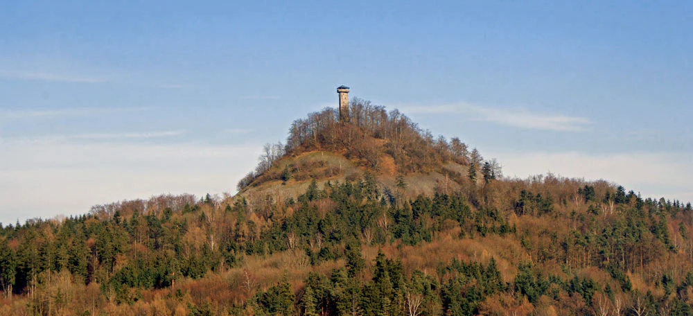
A distant view of a conical mountain, the Rauher Kulm, with a tall observation tower at its summit, surrounded by a forested landscape.
The Rauher Kulm mountain, featuring a prominent observation tower at its peak.

Naturpark Nördlicher Oberpfälzer Wald history and protected-area timeline

The formal designation of Naturpark Nördlicher Oberpfälzer Wald is part of a broader wave of Bavarian Naturpark designations that aimed to protect and promote characteristic rural landscapes. The park covers a large, contiguous area that includes the entire Landkreis Neustadt an der Waldnaab, southern Landkreis Tirschenreuth, and the city of Weiden in der Oberpfalz, deliberately crossing municipal boundaries to create one unified protected region rather than a patchwork of small reserves.

An important institutional step came on 7 May 2009, when the park opened its first information office in the castle grounds at Burgtreswitz. That information point anchored the park's growing role in regional visitor education and local tourism, and reflected the increasing emphasis on public engagement alongside the underlying nature protection goals.

Naturpark Nördlicher Oberpfälzer Wald landscape and geographic character

The dominant landscape of Naturpark Nördlicher Oberpfälzer Wald is the gentle, heavily forested upland of the Oberpfälzer Wald. The terrain is shaped by long ridges and broad valleys, with mixed coniferous and deciduous woodland covering much of the area. Subdued summits give the region an understated, rolling character, in contrast to the sharper peaks of neighboring regions to the north and east.

The highest points in the park include Entenbühl at 901 meters, with Schellenberg (826 m), Eulenberg (817 m), Stückberg (809 m), and Fahrenberg (801 m) all approaching the 800-meter line. Lower, but visually far more distinctive, are geologically outlier landmarks: the conical Rauher Kulm (682 m), famous for its observation tower, and the dark basalt cone of Parkstein (595 m), both volcanic remnants that rise abruptly from the flatter surroundings.

Rivers and streams have carved narrow valleys through the upland, producing corridors of wetland and meadow that contrast with the dense forests above. The Waldnaabtal around the Stadtteil Waldnaab is one such notable valley, together with the Lerautal near Leuchtenberg and smaller valleys sheltering ponds and marshland. Among the broader protected reservoirs and pools, the Vogelfreistätte Weiherhammer and the Schießlweiher near Schwarzenbach contribute to local wetland variety.

Naturpark Nördlicher Oberpfälzer Wald ecosystems, habitats, and plant life

Ecologically, Naturpark Nördlicher Oberpfälzer Wald showcases the typical habitats of the Upper Palatinate: extensive mixed and coniferous forests on acidic soils, clearwater streams bordered by alder and ash, upland moors and peatland remnants, and small-scale agricultural clearings. These different environments sit close together because of the park's large territorial scope, making it possible to walk from mature forest to open mire within a single outing.

Mire habitats are a special focus within the park, with the Naturschutzgebiet Moorgebiet bei Bärnau and the Niedermoorgebiet bei Georgenberg among the most ecologically valuable sites. Both preserve rare bog vegetation, and together with the Torflohe and Pfrentschwiese area, they represent surviving fragments of a once more extensive wetland landscape.

Old-growth forest dynamics are represented by Naturwaldreservat Gscheibte Loh, where natural forest processes are allowed to unfold with minimal intervention, providing a reference point for research and conservation. The Waldnaabtal, Lerautal, and Etzenrichter Kirchberg add river-valley and meadow habitats, while the Vogelfreistätte Weiherhammer and Schießlweiher bring pond and reed environments into the protected-area network.

Naturpark Nördlicher Oberpfälzer Wald wildlife and species highlights

The forested and wetland mosaic of Naturpark Nördlicher Oberpfälzer Wald supports wildlife typical of central European low mountain ranges and upland forests. Continuous wooded tracts provide habitat for deer and smaller forest mammals, while the network of clearings, rivers, and mires creates conditions favorable to a variety of birdlife. The Vogelfreistätte Weiherhammer, formally designated for bird protection, and the pond area at Schießlweiher near Schwarzenbach, are particularly important for waterbirds and species reliant on reed and open-water habitats.

The undisturbed old-growth conditions in Naturwaldreservat Gscheibte Loh support saproxylic communities, including specialist insects, fungi, and cavity-nesting species that depend on decaying wood. Bog remnants near Bärnau and Georgenberg, meanwhile, host specialized mire flora and fauna that have become rare elsewhere in the region. Although species-level detail is limited in the source material, the park's combination of large forest areas, river valleys, and protected wetlands gives it substantial regional significance for biodiversity conservation.

Naturpark Nördlicher Oberpfälzer Wald conservation status and protection priorities

Conservation in Naturpark Nördlicher Oberpfälzer Wald operates at a landscape scale, knitting together forests, river valleys, mires, and old-growth forest reserves under a unified protected-area framework. Within the park, stricter Naturschutzgebiete such as the Moorgebiet bei Bärnau, the Niedermoorgebiet bei Georgenberg, the Waldnaabtal, the Lerautal bei Leuchtenberg, the Etzenrichter Kirchberg, and the Torflohe and Pfrentschwiese protect particularly valuable habitats against more intensive land use.

Naturwaldreservat Gscheibte Loh represents a different but complementary approach, setting aside forest where natural dynamics prevail rather than active management. The Vogelfreistätte Weiherhammer adds a dedicated bird-protection site within the network. Taken together, these protected zones strengthen the ecological value of a park that, by its size and continuity with neighboring Naturparks along the Czech border, also contributes to transboundary habitat connectivity.

Naturpark Nördlicher Oberpfälzer Wald cultural meaning and human context

The cultural landscape of Naturpark Nördlicher Oberpfälzer Wald is shaped by small Upper Palatinate towns whose histories are closely tied to the surrounding forest. The eleven municipalities that form the Naturparkland Oberpfälzer Wald tourism community, including Floß, Flossenbürg, Georgenberg, Leuchtenberg, Moosbach, Pleystein, Tännesberg, Vohenstrauß, Waidhaus, Waldthurn, and the town of Eslarn, share a regional identity built on forestry, small-scale farming, and historical hilltop fortifications such as Leuchtenberg and Tännesberg.

The park's castle at Burgtreswitz, site of the first official Naturpark information office opened in 2009, links local heritage with the modern nature park concept. Across the Oberpfälzer Wald, traditional uses of the landscape, including forestry, hunting, and rural craft, continue to inform how local communities relate to the protected countryside.

Top sights and standout views in Naturpark Nördlicher Oberpfälzer Wald

One of the park's most recognizable landmarks is the Rauher Kulm, a conical volcanic remnant crowned by an observation tower and rising conspicuously above the surrounding landscape. Nearby, the basalt cone of Parkstein offers another striking geological feature and a distinctive hiking destination.

Beyond these geological outliers, the park's highlights include the extensive, continuous forests of the Oberpfälzer Wald, the protected old-growth of Naturwaldreservat Gscheibte Loh, and the ecologically valuable mires near Bärnau and Georgenberg. The network of small historic towns, linked by walking routes, gives the park a particular human dimension, while its position as part of a continuous cross-border nature park corridor adds regional and international significance.

Best time to visit Naturpark Nördlicher Oberpfälzer Wald

The nature park's character shifts with the seasons in ways familiar from other central European low mountain ranges. Spring and early summer bring fresh greenery to the forests, active birdlife around the ponds and mires, and blooming meadows in the river valleys, making this period rewarding for nature observation and hiking.

Late summer and early autumn tend to be a popular time for walking, with generally stable weather, harvest landscapes in agricultural areas, and the visual transition of forests toward autumn colors. Winter can bring snow to the higher ridges, transforming the wooded terrain into a quieter, more subdued environment, although specific winter access conditions are not detailed in the source material.

Monthly climate preview

Long-term monthly temperature and precipitation rhythm for Bavaria

Naturpark Nördlicher Oberpfälzer Wald Climate Normals and Temperature Patterns

Representative coordinates record annual temperature extremes ranging from sub-zero winter minimums to warm summer maximums alongside measured monthly precipitation rates. Detailed multi-year climate normals provide complete statistical context across all twelve months of atmospheric data.
Annual mean8 °C
-3 °C19 °C
Jan-3°
Feb-2°
Mar
Apr
May13°
Jun16°
Jul19°
Aug19°
Sep14°
Oct
Nov
Dec-1°
Warmest month
July

18.7 °C

Coolest month
January

-2.6 °C

Wettest month
June

2.7 mm/day

Driest month
April

1.3 mm/day

Park location guide

Geography guide, regional context, and park location map for Naturpark Nördlicher Oberpfälzer Wald

Naturpark Nördlicher Oberpfälzer Wald park geography, regions, and map view in Germany

Understand where Naturpark Nördlicher Oberpfälzer Wald sits in Germany through a broader geographic reading of the surrounding landscape, nearby location context, and its mapped position within the national park landscape.

How Naturpark Nördlicher Oberpfälzer Wald fits into Germany

Germany is a federal republic in Western and Central Europe with a population of over 83 million across sixteen constituent states. It is Europe's largest economy by nominal GDP and a major global exporter and importer. The capital is Berlin, and the country borders Denmark, Poland, Czech Republic, Austria, Switzerland, France, Luxembourg, Belgium, and the Netherlands.

Wider geography shaping Naturpark Nördlicher Oberpfälzer Wald in Germany

Germany is located in Western and Central Europe, spanning 357,022 km². It borders Denmark to the north, Poland and the Czech Republic to the east, Austria and Switzerland to the south, and France, Luxembourg, Belgium, and the Netherlands to the west. The country has coastlines on the Baltic Sea and North Sea to the north, with the Alps located in the southern region.

Map view of Naturpark Nördlicher Oberpfälzer Wald

Use this park location map to pinpoint Naturpark Nördlicher Oberpfälzer Wald in Germany, understand its exact geographic position, and read its mapped placement within the surrounding landscape more clearly.

Pigeon | © OpenStreetMap contributors

Location context for Naturpark Nördlicher Oberpfälzer Wald

Bavaria
Recorded earthquake history

View Historical Earthquake Data for Naturpark Nördlicher Oberpfälzer Wald

Examine the recorded seismic history of the region surrounding Naturpark Nördlicher Oberpfälzer Wald. This dataset provides factual insight into past seismic events and their proximity to the park boundary, organized for clear geographic reference on MoriAtlas.

Naturpark Nördlicher Oberpfälzer Wald Earthquake Records

Catalogued events

129 events

Strongest magnitude

Magnitude 4.8

Most recent event

May 22, 2018

This history includes earthquakes recorded inside the park or within 50 km of its borders

Visualizing the forested ridges, volcanic cones, and protected river valleys of the Upper Palatinate Forest

Naturpark Nördlicher Oberpfälzer Wald Photos and Landscape Scenery

Visual records capture the heavily forested upland terrain and volcanic landmarks defining Naturpark Nördlicher Oberpfälzer Wald. Photographic documentation provides clear insight into local habitats, river corridors, and protected landscape character across the region.

A distant view of a conical mountain, the Rauher Kulm, with a tall observation tower at its summit, surrounded by a forested landscape.

Park atlas

Compare neighboring Bavarian nature parks and continuous forested uplands along the border.

Parks Near Naturpark Nördlicher Oberpfälzer Wald and Connected Protected Landscapes

Browsing other protected areas near Naturpark Nördlicher Oberpfälzer Wald reveals a continuous belt of forested uplands and river valleys across northeastern Bavaria. Comparing these adjacent nature parks provides broader geographic context for the region's volcanic remnants and woodland terrain.
A soft watercolor painting of a winding river flowing through green rolling hills and meadows under a hazy, bright sky.
Protected landscapeBavaria
Park boundaries overlap#1 closest

West

Naturpark Fränkische Schweiz, Frankenjura: An Atlas of Bavarian Karst and Forested Landscapes

Protected landscape geography within the northern Franconian Jura.

Naturpark Fränkische Schweiz, Frankenjura is a landmark protected area covering over 2,300 square kilometers across Bavaria. Its terrain is defined by a rhythmic sequence of limestone plateaux, winding river valleys, and dolomite formations, balanced by the quieter, pine-dominated reaches of the Veldensteiner Forst. This atlas entry details the park's geological complexity and its significant role in regional conservation.

Area
2,335.44 km²
Established
1968
Relief
Upland
Climate
Temperate
Natural monumentPlzeňský kraj
About 1.1 km away#2 closest

Southeast

Veský mlýn Natural Monument: Geographic Overview and Protected Landscape Mapping

A preserved wetland mosaic in the Bohemian Forest region

Veský mlýn is a protected natural monument in western Bohemia characterized by its transitional mire and wet meadow habitats. Situated within the Plzeňský kraj region, the site provides a distinct look at how former restricted border zones have maintained high ecological value. Its geography includes the headwaters of the Plešský potok and rare flora that thrive in the cool, moist conditions of the local crystalline foothills.

Area
0.321 km²
Established
2002
IUCN
IV
Relief
Upland
Protected landscapeBavaria
About 7.8 km away#3 closest

South

Naturpark Oberpfälzer Wald: Geographic Atlas and Protected Landscape Overview in Bavaria

Examining the terrain, forest ridges, and regional drainage patterns.

Naturpark Oberpfälzer Wald serves as a prominent protected landscape in Bavaria, Germany. This area encompasses a complex of Scots pine and Norway spruce forests, rugged rock outcrops, and the historic Charlottenhofer Weihergebiet. The region connects seamlessly to broader European mountain belts, offering a unique opportunity to study the intersection of traditional land use and natural conservation within the Oberpfalz administrative district.

Area
823 km²
Established
1994
Relief
Mountain
Climate
Temperate
A soft, pastel watercolor painting of a serene pond landscape with gentle green hills, grassy banks, and a light pink and yellow sky.
Nature reservePlzeňský kraj
About 20 km away#4 closest

Southeast

Postřekovské rybníky Nature Reserve: A Detailed Geographic Atlas of Bohemian Wetlands

Protected fishpond landscapes and wetland geography in Plzeňský kraj.

Postřekovské rybníky is a protected nature reserve situated between Postřekov and Klenčí pod Čerchovem. The landscape features over twenty traditionally managed fishponds embedded in a mosaic of damp meadows and stream floodplains. This compact area functions as a significant migratory site and breeding ground, representing a vital remnant of traditional Bohemian land management and specialized wetland ecology.

Area
0.965 km²
Established
1990
IUCN
IV
Relief
Lowland
Nature reserveBavaria
About 23 km away#5 closest

West

Schergenbuck mit Schloss Neidstein: Nature Reserve and Protected Karst Landscape

Forestry and geological mapping of a historic Bavarian ridge

Located in the Amberg-Sulzbach district of Bavaria, this nature reserve integrates historic castle ruins with species-rich deciduous woodland and sensitive karst topography. It remains a key point of interest for understanding how small-scale protected areas preserve biodiversity, including native European yew, against the backdrop of the Franconian Jura landscape.

Area
0.177 km²
Established
1973
IUCN
IV
Relief
Upland
Protected landscapeBavaria
26 km away#6 closest

Northwest

Naturpark Frankenwald: Geographic Profile of Bavaria's Forested Protected Landscape

A vast, interconnected upland spanning the Bavaria and Thuringia border

Naturpark Frankenwald functions as a large-scale managed nature preserve that integrates cultural heritage with ecological conservation. The terrain consists of gentle mountainous ridges, narrow river valleys, and extensive mixed forests that form a continuous landscape belt across northern Bavaria. This profile provides an overview of the regional geography, boundary extent, and the natural features that define this significant central German upland area.

Area
1,023 km²
Established
1973
Relief
Upland
Climate
Temperate
Natural monumentKarlovarský kraj
About 26 km away#7 closest

Northeast

Milhostovské mofety: Geological Atlas of Natural Monuments in Karlovarský kraj

Cold mofette gas vents and wetland floodplain habitat.

Milhostovské mofety is a specialized natural monument protecting a cluster of carbon dioxide mofettes in the Cheb District. This site offers insight into regional post-volcanic phenomena, featuring shallow craters, alder carr landscapes, and amphibolite bedrock structures that illustrate the unique geological character of the Slavkov Forest territory.

Area
0.002 km²
Established
1993
IUCN
III
Relief
Lowland
Nature reserveKarlovarský kraj
About 26 km away#8 closest

North

Pomezní rybník Nature Reserve: Geographic Overview and Protected Wetland Boundaries

Borderland wetland ecology in the Karlovarský kraj region

Pomezní rybník represents a small but significant nature reserve known for its unique location where the state boundary bisects the central pond. The reserve provides a concentrated habitat for wetland species, featuring a rare botanical assemblage and transitional terrain between the lowland basin and highland slopes of the western Czech Republic.

Area
0.017 km²
Established
1990
Relief
Lowland
Scope
Terrestrial

Common questions about visiting, size, designation, and location context for Naturpark Nördlicher Oberpfälzer Wald

Naturpark Nördlicher Oberpfälzer Wald FAQs for park facts, access, geography, and protected area context

Find quick answers about Naturpark Nördlicher Oberpfälzer Wald, including protected-area facts, park geography, trail and visitor context, and how the park fits into its surrounding country and regional landscape.
MoriAtlas Explorer

Continue Your Protected Areas Search Across the Global Atlas

Deepen your exploration by continuing the structured search for national parks and protected areas worldwide. Utilize the comprehensive filtering capabilities to compare different conservation landscapes and refine your understanding of global park geography. Discover more about the distribution and characteristics of protected natural areas.

Global natural geography