
Mori Atlas logo
Nature reserveNaturschutzgebiet Oberes Elpetal

Mapping the stream corridors, floodplain meadows, and natural upland terrain of the Elpe valley.

Naturschutzgebiet Oberes Elpetal: A Protected Sauerland Valley and Riverine Landscape

Naturschutzgebiet Oberes Elpetal preserves a near-natural upland stream corridor along the upper Elpe in Germany. The protected landscape features a mosaic of riparian woodland, traditional wet grasslands, and nutrient-poor meadows within a narrow mountain valley. This reserve serves as a critical geographic node in the regional landscape plan for Olsberg, demonstrating the ecological connectivity of Sauerland valley systems.

stream valleyriparian habitatfloodplain meadowwet grasslandnutrient-poor grasslandSauerland
A flat, vector-style illustration of a valley landscape featuring a winding river, a waterfall descending from rocky cliffs, a small wooden cabin, evergreen and deciduous trees, and a road under a bright sun.

Naturschutzgebiet Oberes Elpetal

Nature reserve

Park overview

Structured park overview, official facts, and landscape profile for Naturschutzgebiet Oberes Elpetal

Naturschutzgebiet Oberes Elpetal park facts, protected area profile, and essential visitor context

Review the core facts for Naturschutzgebiet Oberes Elpetal, including designation, size, terrain, visitor scale, habitats, and operating context in one park-focused overview.

About Naturschutzgebiet Oberes Elpetal

Naturschutzgebiet Oberes Elpetal is a small but ecologically focused nature reserve in the Hochsauerlandkreis, set in the rolling hill landscape of the eastern Sauerland in North Rhine-Westphalia. The reserve follows the upper stretch of the Elpe, a tributary in the river network of the region's upland valleys, from the municipal border with Winterberg in the south down to the village of Elpe, which lies just to the north of the protected area.

The defining character of the area is a near-natural hillside stream and its narrow floodplain. The Elpe flows through the reserve from south to north, accompanied by a short unnamed tributary that enters the main stream at the southern end of the area. Strips of riparian woodland line the banks, while the wider valley floor supports a patchwork of wet grassland and nutrient-poor, formerly hay-cut meadows. A few small fish ponds add further aquatic habitat diversity within the reserve.

Traditional land use remains part of the reserve's identity: the meadows are mostly grazed by cattle and horses, a continuation of the farming pattern that shaped the valley for generations. Four small fish ponds also remain within the protected area. To the south, the reserve connects to the larger Landschaftsschutzgebiet Talsystem der Elpe, and the protected zone extends right up to the edge of the village of Elpe, where the cultural landscape meets the intact valley system.

Together, these features make Oberes Elpetal a representative example of a small-scale Sauerland valley reserve, where the protection of a near-natural stream corridor, floodplain meadows, and traditional grassland use comes together in a compact area.

Quick facts and research context for Naturschutzgebiet Oberes Elpetal

Naturschutzgebiet Oberes Elpetal is an 11.2-hectare nature reserve in the Hochsauerlandkreis district of North Rhine-Westphalia, located on the upper Elpe river south of the village of Elpe within the town of Olsberg. It was designated as a Naturschutzgebiet in 2004 as part of the Olsberg landscape plan and is administered by the lower landscape authority of the Hochsauerlandkreis.

The protected area is classified under IUCN Category IV (Habitat/Species Management Area) and is recorded in the German protected-area register under the code HSK-252. To the south it borders the larger Landschaftsschutzgebiet Talsystem der Elpe, extending the network of protected valley landscapes along the Elpe river.

Protection and recognition

Examine documented protected area designation records and official recognition

Naturschutzgebiet Oberes Elpetal Protection Status and Conservation Data

Naturschutzgebiet Oberes Elpetal protection status details offer verified conservation data and administrative records. Recorded protected area designation metrics provide clear reference points for researchers analyzing regional environmental boundaries.

Protection details

WDPA ID
329551
Park context

Deeper park guide and search-rich context for Naturschutzgebiet Oberes Elpetal

Naturschutzgebiet Oberes Elpetal history, landscape, wildlife, and travel context

Explore Naturschutzgebiet Oberes Elpetal through its history, landscape character, ecosystems, wildlife, conservation priorities, cultural context, and seasonal travel timing in a structured park guide built for atlas discovery and search intent.

Why Naturschutzgebiet Oberes Elpetal stands out

The reserve is best known for its near-natural upper course of the Elpe stream and the small-scale, traditionally used floodplain meadows that line it. It showcases the classic Sauerland valley setting: a clear, slow-flowing upland brook, riparian shrubs, wet and nutrient-poor grasslands, and pockets of habitat contributed by small fish ponds and spring-fed features. Its ecological value lies in the combination of an intact valley stream corridor with species-rich, traditionally grazed meadows, supporting both moisture-loving wetland plants and characteristic grassland flora of the upland region.
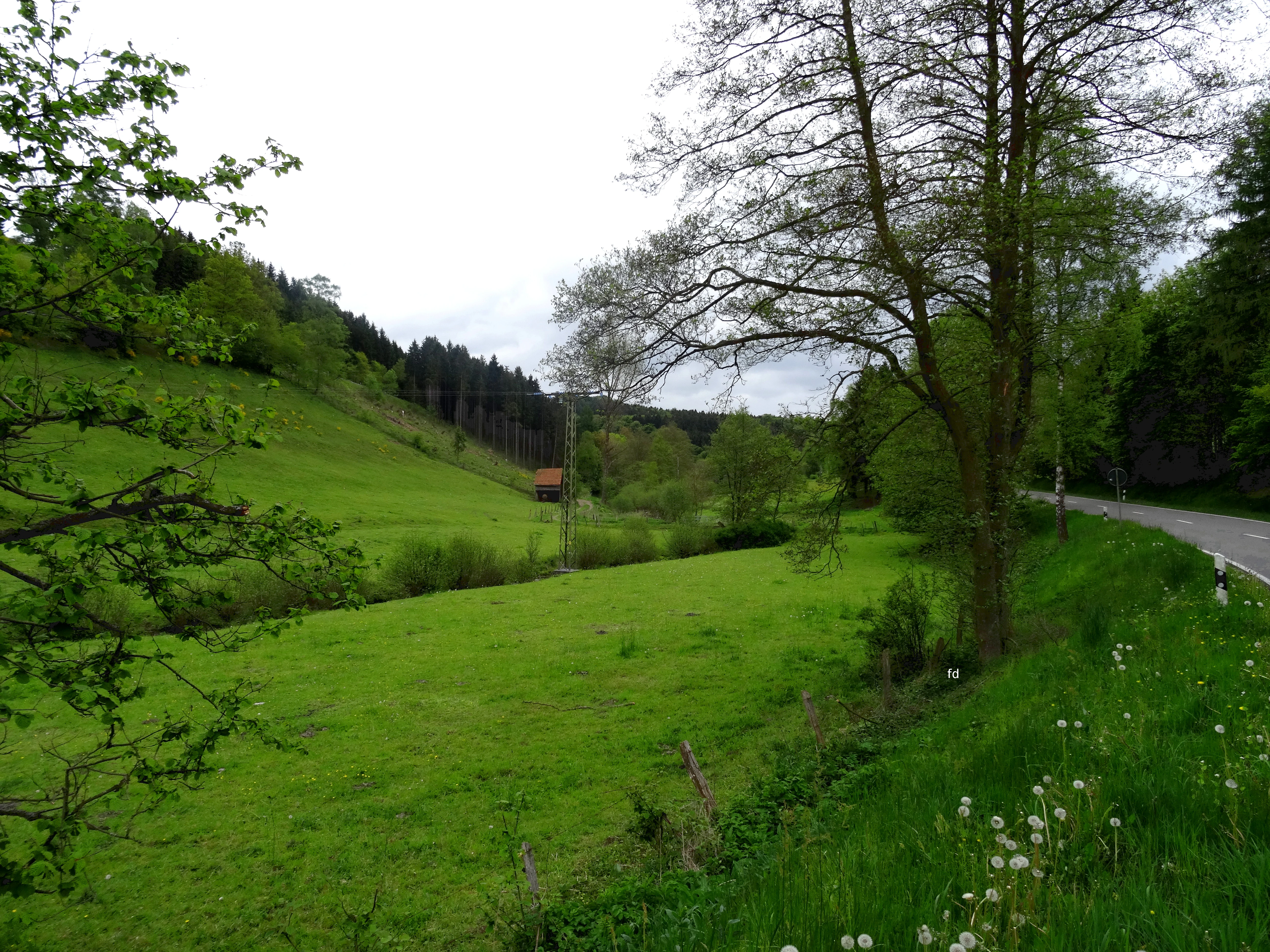
A green valley scene with a meadow, trees, and a road running along the right side of the frame.
View of the Elpe valley within the Naturschutzgebiet Oberes Elpetal, showing the river floodplain and the nearby road.

Naturschutzgebiet Oberes Elpetal history and protected-area timeline

The Oberes Elpetal reserve was formally designated as a Naturschutzgebiet in 2004, when the Untere Landschaftsbehörde of the Hochsauerlandkreis set it apart as part of the broader Olsberg landscape plan. The designation built on a long-standing recognition of the Elpe valley as an ecologically valuable landscape, integrating the area into a wider regional framework of protected valley landscapes in the Sauerland.

By incorporating the Oberes Elpetal as part of the larger Talsystem der Elpe landscape protection area to the south, the Hochsauerlandkreis consolidated protection for a continuous stretch of the Elpe river system. The reserve reflects the continuation of traditional land use in the valley, particularly the grazing of valley meadows, as part of an effort to maintain both the cultural and ecological character of the Sauerland stream valleys.

Naturschutzgebiet Oberes Elpetal landscape and geographic character

The reserve occupies a compact stretch of the upper Elpe valley, a typical narrow Sauerland valley with a clear stream winding along the valley floor between wooded upper slopes. The Elpe enters from the south near the border with Winterberg and exits the area in the north at the edge of the village of Elpe, giving the reserve a clear linear, valley-based shape.

The terrain is shaped by the river itself: low floodplain terraces along the stream, gentle slopes transitioning into the surrounding hills, and small structural features such as the short unnamed tributary, the small fish ponds, and wet depressions in the meadows. The valley feels sheltered, with the wooded banks and riparian strips giving way to more open grassland as the small valley floor widens slightly. To the south, the protected area connects visually and ecologically to the larger Elpe valley landscape protection area, forming part of a continuous valley landscape through the Hochsauerland region.

Naturschutzgebiet Oberes Elpetal ecosystems, habitats, and plant life

Ecologically, the reserve is centered on the near-natural Elpe stream and its small floodplain, where moist conditions along the banks grade into drier, nutrient-poor grasslands farther from the water. This creates a transitional habitat mosaic in a very compact area, combining wetland, riparian, and semi-dry grassland communities in a way that is increasingly rare in the intensively used upland landscapes of North Rhine-Westphalia.

Along the stream, riparian woodland, wet meadows, and small spring-fed features support moisture-loving plant communities, while the more elevated parts of the floodplain retain the character of traditional, species-rich meadows with low nutrient input. The short unnamed tributary adds additional spring and seepage habitat in the southern part of the area.

A long list of characteristic plant species has been documented in the area by the state agency for nature, environment, and consumer protection of North Rhine-Westphalia. These include moisture indicators such as brooklime, bittercress, marsh marigold, marsh forget-me-not, and marsh bedstraw, as well as traditional grassland species like great burnet, devil's-bit scabious, ragged robin, and the meadow daisy-like species that thrive under extensive grazing. Ferns such as male fern and lady fern are found along the wooded margins, and species such as heath star moss and quill moss indicate the persistence of damp, near-natural microhabitats.

Naturschutzgebiet Oberes Elpetal wildlife and species highlights

The reserve's wildlife value is primarily linked to the structure of the Elpe stream, the riparian woodland, and the traditionally grazed meadows. The near-natural stream and its small fish ponds provide habitat for aquatic and semi-aquatic species typical of Sauerland brooks, while the wooded banks and shrubs offer cover and food resources for typical small woodland fauna.

The mosaic of wet grassland, drier nutrient-poor meadow, and bank-side shrub creates conditions for insects, pollinators, and other invertebrates associated with species-rich, low-input grasslands, which in turn support the broader food web of small birds and other valley wildlife. The continuation of grazing by cattle and horses is itself a defining feature of the reserve's ecological character, helping to maintain open meadow conditions rather than scrub encroachment.

Naturschutzgebiet Oberes Elpetal conservation status and protection priorities

The conservation purpose of the reserve focuses on protecting the Elpe stream itself and its floodplain habitats. As with all formal German Naturschutzgebiete, the designation cites the rarity, distinctive character, and natural beauty of the area as the basis for its protected status.

In practice, this means safeguarding a near-natural upland stream environment with intact bank-side vegetation, preserving the traditional wet and nutrient-poor meadows from intensification or conversion, and maintaining the small-scale landscape mosaic that links aquatic, riparian, and grassland habitats. The reserve fits into a larger regional conservation approach through its connection to the adjoining Landschaftsschutzgebiet Talsystem der Elpe, contributing to a continuous protected valley corridor along the upper Elpe river.

Naturschutzgebiet Oberes Elpetal cultural meaning and human context

The Elpe valley has long been a working agricultural landscape, and traces of this history remain visible in the reserve today. The floodplain meadows are still mostly grazed by cattle and horses, a continuation of farming practices that shaped the valley over generations and which now themselves help maintain the species-rich, open meadow character that the reserve aims to protect.

The Oberes Elpetal reserve also forms part of the local identity of the village of Elpe itself, lying directly adjacent to the settlement and extending the protected landscape right up to the edge of the village. Together with the broader Talsystem der Elpe landscape protection area, it is part of the regional heritage of the Sauerland valleys, where small mountain villages and traditionally used valley meadows have coexisted for centuries.

Top sights and standout views in Naturschutzgebiet Oberes Elpetal

A small but ecologically concentrated Sauerland stream valley reserve, protecting a near-natural stretch of the upper Elpe and its floodplain meadows from the Winterberg border down to the village of Elpe. Its strength lies in the combination of intact riparian woodland along the Elpe, the short unnamed tributary joining from the south, the small fish ponds, and the traditionally grazed wet and nutrient-poor grasslands that together create a compact and ecologically rich valley landscape.

The reserve is notable not for dramatic scenery but for its representative role: a textbook example of a small Sauerland valley protected area, embedded in a larger network of Elpe valley landscape protection and managed as part of the Olsberg landscape plan of the Hochsauerlandkreis.

Best time to visit Naturschutzgebiet Oberes Elpetal

The character of the reserve varies across the seasons in ways typical of small Sauerland stream valleys. Late spring and early summer are attractive for viewing species-rich meadows and flowering wet-grassland plants, while early summer evenings can be particularly lively with insects along the meadows and stream margins.

Late summer and early autumn bring a quieter atmosphere, with the meadows in their grazed post-flowering state and the bordering woodland showing changing color. Winter visits are possible, but the high-elevation valley location and the modest size of the reserve mean visitors should expect short days, cooler temperatures, and generally muted vegetation colors at this time.

Monthly climate preview

Long-term representative temperature and precipitation averages by month

Naturschutzgebiet Oberes Elpetal Climate Normals and Annual Weather Patterns

Temperature and precipitation data for Naturschutzgebiet Oberes Elpetal outline a measured annual cycle based on multi-year representative coordinate sampling. Reviewing the complete monthly records provides deeper context for long-term climatic patterns across the protected area.
Annual mean9 °C
0 °C18 °C
Jan
Feb
Mar
Apr
May12°
Jun15°
Jul18°
Aug18°
Sep14°
Oct
Nov
Dec
Warmest month
July

18 °C

Coolest month
January

-0.2 °C

Wettest month
July

2.6 mm/day

Driest month
April

1.7 mm/day

Park location guide

Geography guide, regional context, and park location map for Naturschutzgebiet Oberes Elpetal

Naturschutzgebiet Oberes Elpetal park geography, regions, and map view in Germany

Understand where Naturschutzgebiet Oberes Elpetal sits in Germany through a broader geographic reading of the surrounding landscape, nearby location context, and its mapped position within the national park landscape.

How Naturschutzgebiet Oberes Elpetal fits into Germany

Germany is a federal republic in Western and Central Europe with a population of over 83 million across sixteen constituent states. It is Europe's largest economy by nominal GDP and a major global exporter and importer. The capital is Berlin, and the country borders Denmark, Poland, Czech Republic, Austria, Switzerland, France, Luxembourg, Belgium, and the Netherlands.

Wider geography shaping Naturschutzgebiet Oberes Elpetal in Germany

Germany is located in Western and Central Europe, spanning 357,022 km². It borders Denmark to the north, Poland and the Czech Republic to the east, Austria and Switzerland to the south, and France, Luxembourg, Belgium, and the Netherlands to the west. The country has coastlines on the Baltic Sea and North Sea to the north, with the Alps located in the southern region.

Map view of Naturschutzgebiet Oberes Elpetal

Use this park location map to pinpoint Naturschutzgebiet Oberes Elpetal in Germany, understand its exact geographic position, and read its mapped placement within the surrounding landscape more clearly.

Pigeon | © OpenStreetMap contributors

Location context for Naturschutzgebiet Oberes Elpetal

Nordrhein-Westfalen

Visual exploration of Sauerland stream valleys and protected riparian habitats

Naturschutzgebiet Oberes Elpetal Photos and Landscape Scenery

Visual records reveal the intimate terrain and protected habitats of Naturschutzgebiet Oberes Elpetal, showcasing winding stream corridors and floodplain meadows. Photographic documentation highlights the distinct ecological features of the upper Elpe valley environment.

A green valley scene with a meadow, trees, and a road running along the right side of the frame.

Park atlas

Compare regional stream valleys and connected upland reserves across the Sauerland territory.

Explore Other Parks Near Naturschutzgebiet Oberes Elpetal and Surrounding Protected Landscapes

Browse protected areas near Naturschutzgebiet Oberes Elpetal to examine neighboring stream corridors and upland valley ecosystems. Continued geographic comparison reveals how regional conservation networks connect lowland mountain habitats throughout the surrounding terrain.
A horizontal watercolor illustration depicting a soft, impressionistic landscape with rolling hills, meadows, and trees in shades of green, pink, and light grey.
Nature reserveHochsauerlandkreis
About 3.8 km away#1 closest

North

Naturschutzgebiet Plästerlegge, Auf’m Kipp: Protected Nature Reserve and Gorge Geography

Mapped ravine forests and high moor terrain in Hochsauerlandkreis

This protected area centers on the Plästerlegge waterfall and its steep slate gorge within the Sauerland mountains. The reserve offers a rare look at humid microclimate flora, silverleaf ravine forests, and a high-elevation peatland basin. Explore the precise landscape boundaries and ecological terrain that define this protected forest mosaic in western Germany.

Area
0.285 km²
Established
1952
Relief
Upland
Climate
Temperate
Nature reserveNordrhein-Westfalen
About 4.8 km away#2 closest

West

Naturschutzgebiet Palmetal Protected Area Map and Sauerland Highland Landscape Context

Stream corridors and floodplain meadows in Nordrhein-Westfalen

Located in the foothills of the Rothaargebirge, Naturschutzgebiet Palmetal preserves a cohesive upland stream ecosystem. The reserve centers on the Palme and Brabecke brooks, protecting 11.7 hectares of wet meadow and gallery forest habitats. This site provides a representative look at the small-scale valley landscapes found within the Hochsauerlandkreis region, emphasizing the interplay between waterway, floodplain, and local terrain.

Area
0.117 km²
Established
2008
IUCN
IV
Relief
Upland
Nature reserveNorth Rhine-Westphalia
About 4.8 km away#3 closest

East

Naturschutzgebiet Olsberger Ruhrtal oberhalb Assinghausen: Protected River Corridor and Valley Geography

Nature reserve featuring floodplain habitats in the Sauerland region

This nature reserve protects the natural flow and riparian ecosystem of the upper Ruhr river. Comprising three distinct sections, it serves as an important ecological link within the Sauerland landscape, preserving floodplain meadows and the river channel corridor. The area represents a focused approach to river-centered conservation in North Rhine-Westphalia, providing a clear example of protected habitat integration within the German landscape.

Area
0.155 km²
Established
2004
Relief
Lowland
Scope
Terrestrial
Nature reserveNordrhein-Westfalen
About 5.3 km away#4 closest

West

Naturschutzgebiet Oegmannsholz: Protected Forest and Geological Landscapes in Nordrhein-Westfalen

A dense nature reserve featuring beech woodland, rock formations, and valley springs.

Naturschutzgebiet Oegmannsholz represents a concentrated protected area within the Sauerland region of Germany. This reserve safeguards diverse forest microhabitats, including mature beech stands and steep drainage lines known as Kerbtalsiepen. Its structural variety, from rocky outcrops to flowing springs, creates a distinct natural terrain within the broader North Rhine-Westphalia conservation network.

Area
0.113 km²
Established
2008
IUCN
IV
Nature reserveNorth Rhine-Westphalia
About 7.3 km away#5 closest

Southeast

Naturschutzgebiet Oberes Ruhrtal: Mapping the Sauerland Headwater Valley Landscape

Protected grassland and river valley geography

Discover the topography and protected boundaries of Naturschutzgebiet Oberes Ruhrtal. This nature reserve in North Rhine-Westphalia preserves a classic headwater valley, where the young Ruhr meanders through nutrient-poor meadows, wet grasslands, and varied riparian terrain, offering a clear example of traditional agricultural landscape conservation.

Area
0.553 km²
Established
2008
IUCN
IV
Relief
Upland
A watercolor painting of a serene landscape featuring rolling green hills in the distance, a line of trees in the middle ground, and a small winding stream in the foreground.
Protected landscapeHochsauerlandkreis
About 7.6 km away#6 closest

Northwest

Landschaftsschutzgebiet Bestwig: Mapped Protected Landscape in the Hochsauerland District

Geography, forest ridges, and historic mining terrain

Landschaftsschutzgebiet Bestwig covers significant portions of the central Sauerland, integrating forest crests and river valley slopes into a single protected area. The geography reveals a complex interaction between agricultural plantation land, unpopulated northern forest ridges, and historic mining remnants that define this distinct German landscape.

Area
49.12 km²
Established
2008
Relief
Mountain
Water
Minor water
Nature reserveNordrhein-Westfalen
About 9 km away#7 closest

East

Hoppecke-Quellbäche Nature Reserve: Protected Headwater Landscapes in Nordrhein-Westfalen

Highland spring and mountain brook habitats within the Rothaargebirge

Hoppecke-Quellbäche safeguards essential headwater habitats across the mid-slopes of the Clemensberg and the high ground leading to the Langenberg. This nature reserve, organized into three distinct parcels, maps the hydrological connections that feed the upper Hoppecke stream within the broader protected-area network of the northern Sauerland region.

Area
0.169 km²
Established
2008
IUCN
IV
Relief
Mountain
Nature reserveHochsauerlandkreis
About 9.2 km away#8 closest

West

Naturschutzgebiet Piepenbruchsiepen: Protected Landscape and Mountain Brook Geography

Mapping nature reserves in the Hochsauerlandkreis region

This nature reserve covers a steep, forested valley in the Hochsauerlandkreis, showcasing a classic Sauerland Siepen. The terrain is defined by a rocky mountain brook, seeping springs, and structurally rich beech forests that preserve native biodiversity within a heavily managed timber landscape.

Area
0.077 km²
Established
2020
Relief
Mountain
Scope
Terrestrial

Common questions about visiting, size, designation, and location context for Naturschutzgebiet Oberes Elpetal

Naturschutzgebiet Oberes Elpetal FAQs for park facts, access, geography, and protected area context

Find quick answers about Naturschutzgebiet Oberes Elpetal, including protected-area facts, park geography, trail and visitor context, and how the park fits into its surrounding country and regional landscape.
MoriAtlas Explorer

Continue Your Protected Areas Search Across the Global Atlas

Deepen your exploration by continuing the structured search for national parks and protected areas worldwide. Utilize the comprehensive filtering capabilities to compare different conservation landscapes and refine your understanding of global park geography. Discover more about the distribution and characteristics of protected natural areas.

Global natural geography