
Mori Atlas logo
Nature reserveNeuwiese von Messel

Mapping the landscape structure and conservation boundaries within the Messeler Hügelland region

Neuwiese von Messel Nature Reserve: A Protected Mosaic of Forests and Wet Meadows in Hesse

(Naturschutzgebiet Neuwiese von Messel)

Neuwiese von Messel stands as a significant nature reserve in the southern Hesse region, covering a distinctive landscape of damp meadow clearings embedded within mixed deciduous woodland. This protected area, situated in the Landkreis Darmstadt-Dieburg, preserves traditional meadow and forest communities through long-standing, low-intensity land management practices. As a key component of the Natura 2000 network, it provides essential habitat types that illustrate the ecological relationship between open grassland and mature oak-hornbeam forest in the German hill country.

nature reservewet meadowoak-hornbeam forestbeech forestfloodplain woodlandMolinion caeruleae
A flat-style digital illustration showing a waterfall flowing down between mountains into a river, surrounded by trees, grassy meadows, and wildflowers.

Neuwiese von Messel

Nature reserve

Park overview

Structured park overview, official facts, and landscape profile for Neuwiese von Messel

Neuwiese von Messel park facts, protected area profile, and essential visitor context

Review the core facts for Neuwiese von Messel, including designation, size, terrain, visitor scale, habitats, and operating context in one park-focused overview.

About Neuwiese von Messel

Neuwiese von Messel lies in the heart of the Messeler Hügelland, a gentle hilly landscape in the Darmstadt-Dieburg district of southern Hesse. The nature reserve stretches across roughly 107 hectares in two separate parcels, one north and one south of the district road K 180 linking Messel and Eppertshausen. Since 2008, the southern portion has been integrated into the broader Natura 2000 site "Neuwiese und Wald nordöstlich von Messel," recognizing the area's value within the European network of protected habitat sites.

The reserve protects a long-established pattern of wet meadows embedded within mixed deciduous forest. These meadows function as open clearings within the surrounding Messeler Wald, and the varied edges between open ground and woodland are central to the site's ecological character. Several drainage ditches traverse the meadows, reflecting the long history of water management in this low-lying terrain. The combination of damp soils, varied forest types, and regularly mown open areas creates conditions that are increasingly rare in modern central European landscapes.

Protected under a 1986 ordinance and extended in 1994, the area safeguards plant communities of wet meadows and species-rich oak-hornbeam woodland, as well as the habitat, feeding, and breeding conditions required by threatened animal species, particularly meadow-breeding birds. The reserve's overlapping status as a national nature reserve and an EU-level FFH site underlines its dual role as a regional and European conservation resource.

Beyond its ecological importance, the site carries a deep cultural landscape history. The name "Neuwiese" appears in historical records as early as 1518, documented as "Naue wyße" or "newe wiesen," and extensive mowing and grazing use of these forest clearings has been recorded since the 16th century. The current biodiversity of the meadows is in large part the result of this long continuity of extensive traditional management, sustained today through conservation mowing and active woodland edge care.

Quick facts and research context for Neuwiese von Messel

Neuwiese von Messel is a nature reserve (Naturschutzgebiet) in the Messeler Hügelland of southern Hesse, Germany, located about three kilometers east of the village of Messel. The reserve covers approximately 107 hectares across two parcels, north and south of a district road between Messel and Eppertshausen. It has been formally protected since 20 March 1986, with boundary extensions adopted on 31 October 1994. Since 2008, the southern portion has been part of the Natura 2000 site FFH-Gebiet 6018-307 ("Neuwiese und Wald nordöstlich von Messel"). The reserve is classified as an IUCN Category IV Habitat/Species Management Area, and its main aim is to protect wet meadow communities and species-rich oak-hornbeam woodland as habitats for threatened flora and meadow-breeding birds.

Protection and recognition

Examine the terrestrial protection history and management framework established in 1994.

Neuwiese von Messel Protection Status and Designated Area Record

Neuwiese von Messel holds a documented terrestrial protection status established in 1994, reflecting structured conservation tracking across official databases. Review the recorded management scope and administrative designation details for this protected area.

Protection details

Protection scope
Terrestrial
Designated year
1994
Transboundary protection
No
WDPA ID
164803
Park context

Deeper park guide and search-rich context for Neuwiese von Messel

Neuwiese von Messel history, landscape, wildlife, and travel context

Explore Neuwiese von Messel through its history, landscape character, ecosystems, wildlife, conservation priorities, cultural context, and seasonal travel timing in a structured park guide built for atlas discovery and search intent.

Why Neuwiese von Messel stands out

Neuwiese von Messel is best known for its exceptional concentration of rare meadow plants in spring, set within a historic forest clearing system that has been maintained through low-intensity mowing and grazing since at least the 16th century. The reserve harbors habitat types such as Molinion caeruleae wet meadows, lowland hay meadows, and submontane mat-grass swards, alongside oak-hornbeam forest, woodruff beech forest, and alder floodplain woodland. It is also notable for supporting the dusky large blue butterfly, a species tied specifically to the meadow-forest mosaic that defines this protected area.
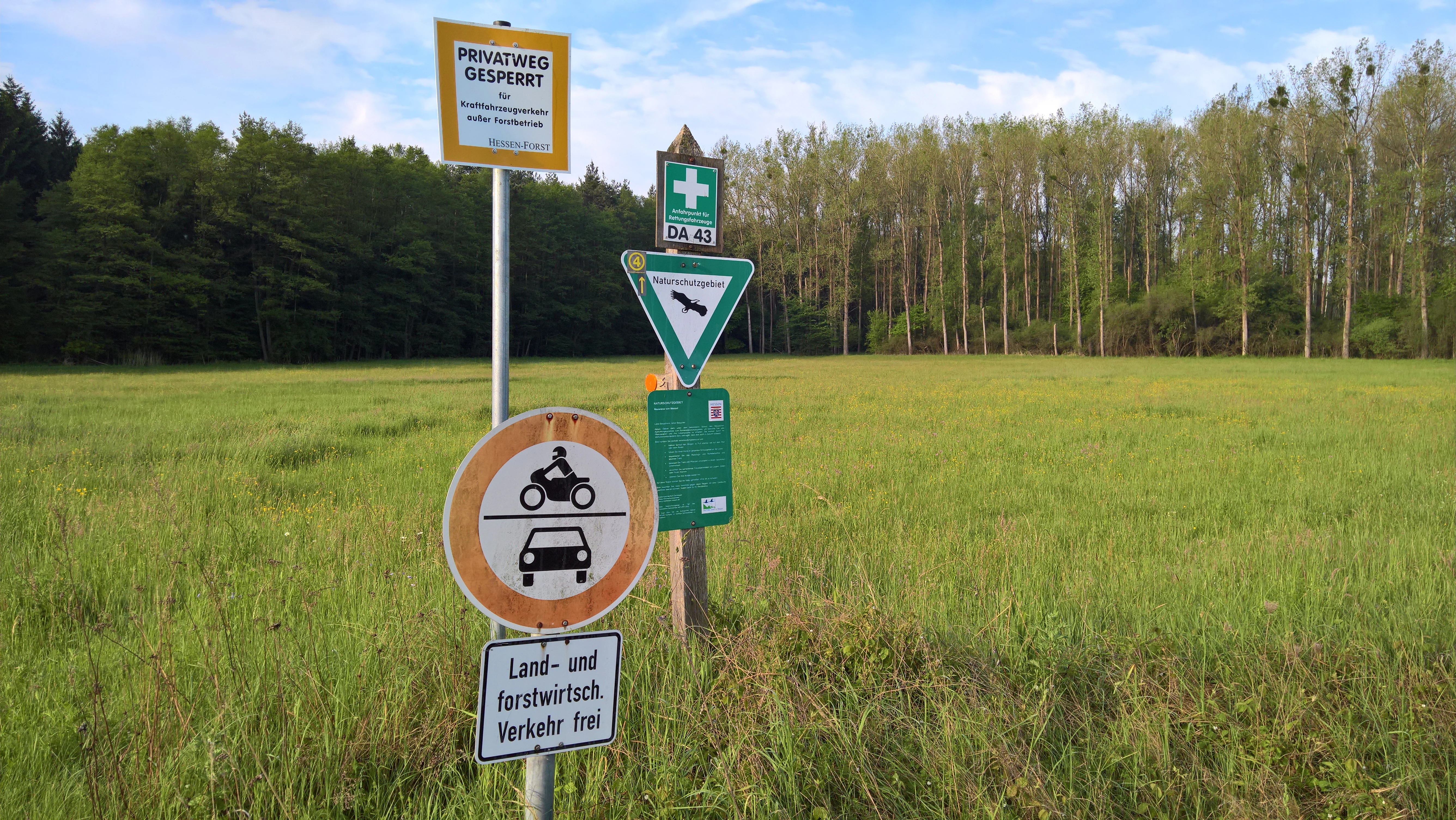
A group of traffic and nature reserve signs standing on a metal pole in front of a green meadow and a line of trees.
Information and traffic restriction signs at the entrance to the Neuwiese von Messel nature reserve.

Neuwiese von Messel history and protected-area timeline

The meadows of Neuwiese von Messel have been documented in historical records since at least 1518, when the area was mentioned under the place names "Naue wyße" and "newe wiesen." Extensive mowing and grazing use of these forest clearings has been recorded continuously since the 16th century, establishing a centuries-long tradition of low-intensity land management that has shaped the present-day mosaic of meadow and woodland.

The formal protection of the area began on 20 March 1986, when the Neuwiese von Messel was designated as a nature reserve (Naturschutzgebiet) under Hessian conservation law. The boundaries and protective provisions were extended and refined on 31 October 1994, reinforcing the reserve's role as a long-term conservation site for wet meadow vegetation and oak-hornbeam woodland.

In 2008, the southern portion of the reserve became part of the larger European Natura 2000 site "Neuwiese und Wald nordöstlich von Messel," designated as FFH-Gebiet 6018-307. This inclusion integrated the area into the EU-wide network for the protection of natural habitat types and species, adding an international conservation dimension to its existing national protection.

Neuwiese von Messel landscape and geographic character

Neuwiese von Messel occupies a softly undulating section of the Messeler Hügelland, the gentle hill country of southern Hesse that surrounds the famous Messel fossil site. The protected area consists of wet meadow clearings embedded within the larger Messeler Wald, with the meadows forming open "forest islands" surrounded by mixed deciduous woodland. This landscape pattern of clearings within forest is one of the reserve's most distinctive physical features.

The reserve is divided into two main sections by the district road K 180 between Messel and Eppertshausen, with meadow and forest zones lying both to the north and to the south of this road. Several drainage ditches run across the meadows, indicating the long-standing need to manage the naturally damp soils of the site. The terrain is low and gently rolling rather than steep, with the wet meadow habitat reflecting the area's hydrology combined with centuries of traditional land use.
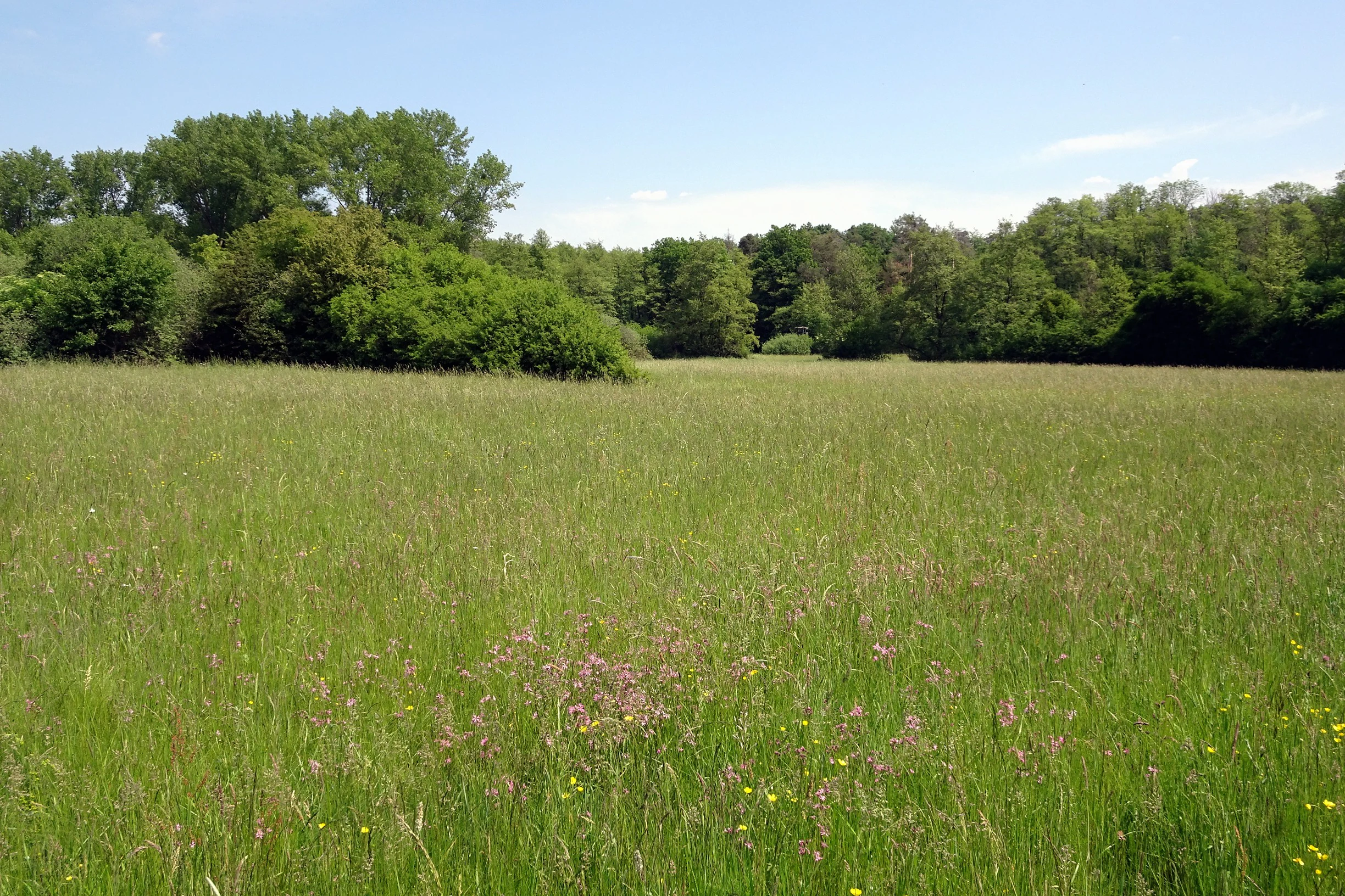
A wide view of a vibrant green meadow during a bright day, surrounded by a dense forest boundary under a blue sky.
A lush meadow landscape in the Neuwiese von Messel nature reserve, characterized by tall grasses and wildflowers.

Neuwiese von Messel ecosystems, habitats, and plant life

The nature reserve is defined ecologically by the close interweaving of wet meadow habitats and old deciduous forest. The meadows include habitat types protected under the EU Habitats Directive, such as Molinion caeruleae purple moor-grass meadows on calcareous, peaty, or clay-rich soils, species-rich lowland hay meadows with Alopecurus pratensis and Sanguisorba officinalis, and small patches of montane and submontane mat-grass swards on siliceous substrates. In spring, the meadows display a dense concentration of rare flowering plants, including Siberian iris and broad-leaved marsh orchid, while the open grass swards support specialized insects such as the dusky large blue butterfly.

The woodland portions of the reserve are equally diverse, encompassing oak-hornbeam forest, woodruff beech forest, and, on the wettest soils, alder floodplain woodland dominated by Alnus glutinosa and Fraxinus excelsior. In the northern parts of the site, luzule beech forest is also present. The transition zones, where forest gradually opens into hay meadow and wet grassland, are an essential part of the site's ecological identity and a key focus of ongoing conservation management.
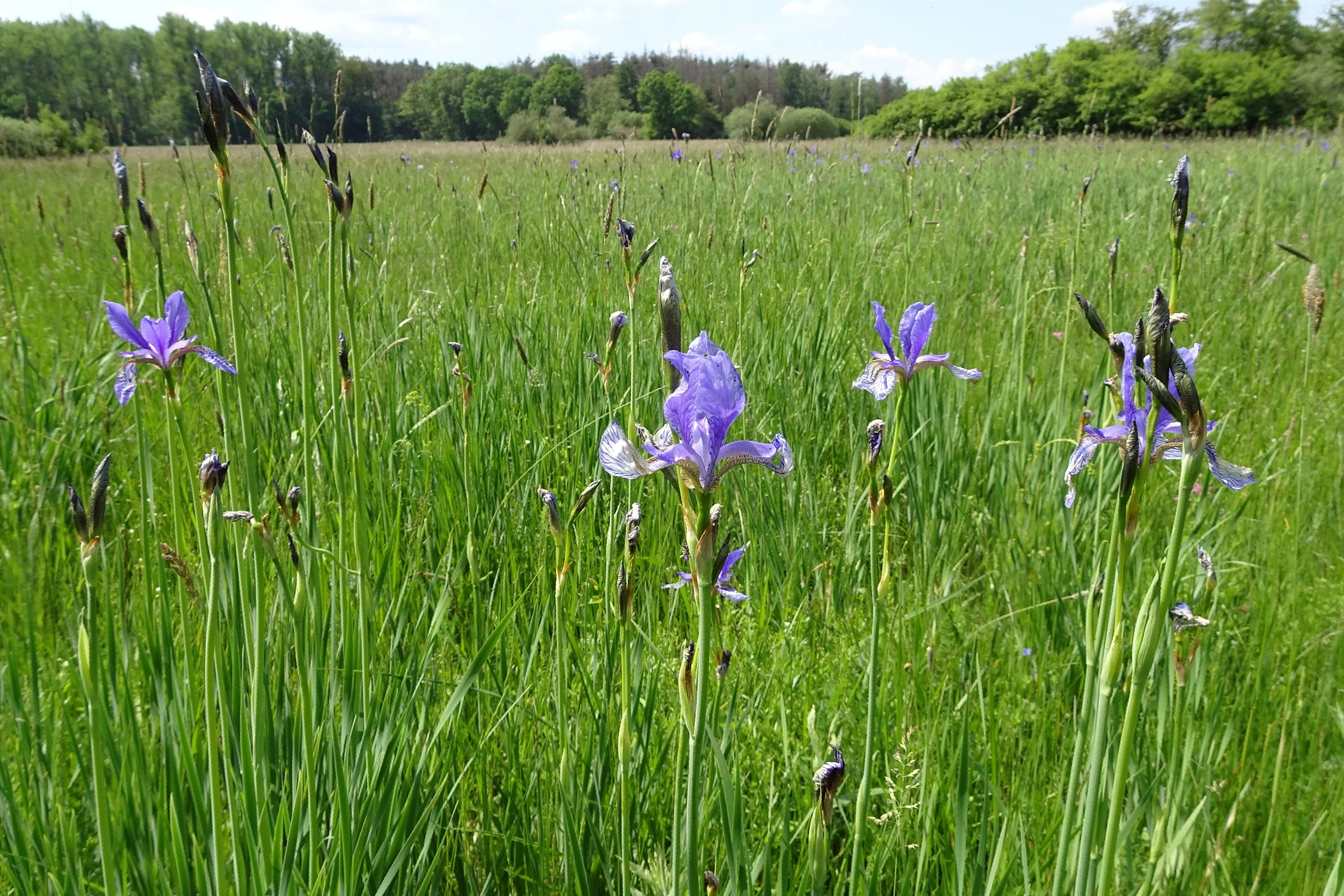
Several purple Siberian iris flowers growing among tall green grasses in an open meadow with a tree line in the background.
Siberian iris blooming in a wetland meadow at Neuwiese von Messel.

Neuwiese von Messel wildlife and species highlights

Neuwiese von Messel's wildlife value centers on meadow-breeding birds, which depend on the open grassland and adjacent woodland structure that the reserve preserves. The protected status explicitly aims to secure and develop the meadows and surrounding forest as breeding, feeding, and shelter habitat for threatened bird species tied to this kind of habitat mosaic.

The reserve also supports a notable invertebrate fauna. The dusky large blue butterfly (Maculinea nausithous) is documented in the meadows, along with other species whose life cycles are tied to the specific wildflower communities present here. Wild boar activity on the site contributes to soil disturbance that can favor the spread of certain grasses, unintentionally supporting the openness and varied structure of the meadow swards.
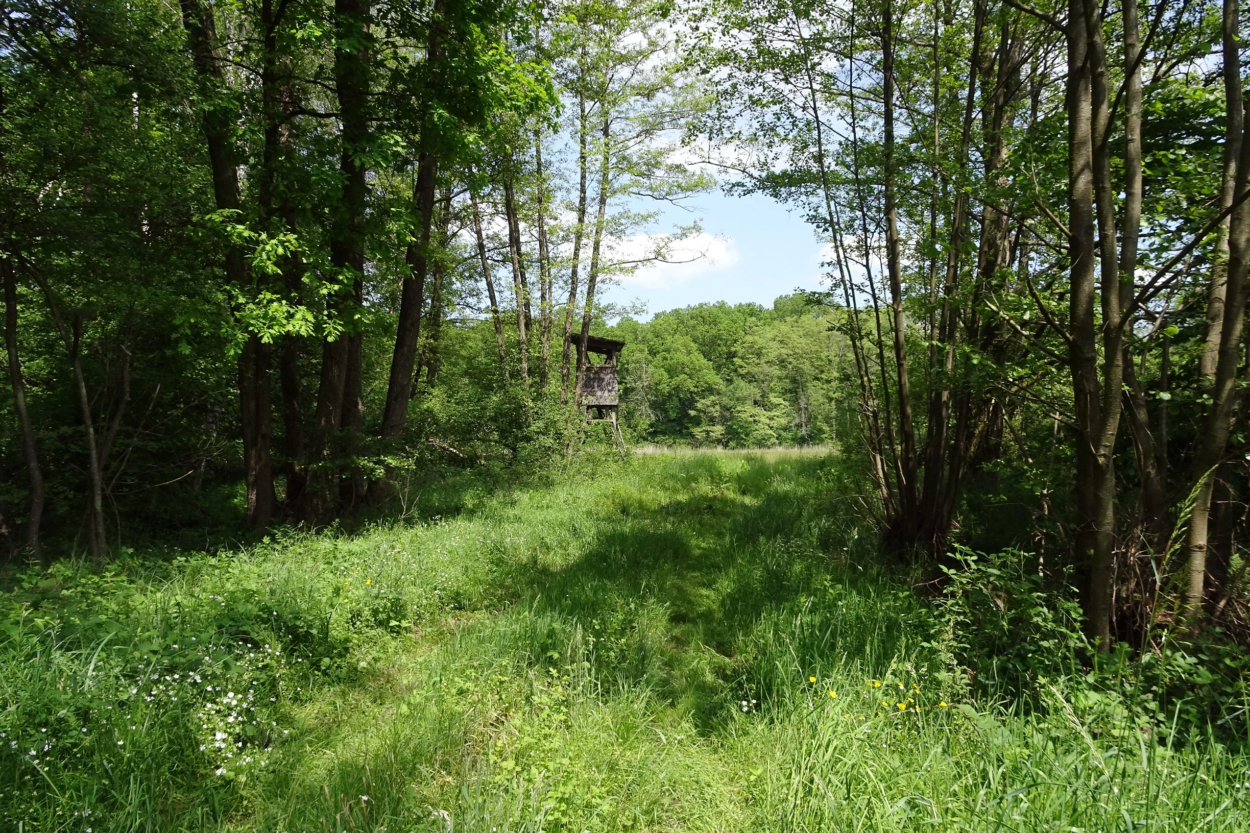
A green meadow path leads toward a small wooden hunting stand visible in the distance, framed by mature trees in a forest.
A grassy clearing surrounded by deciduous forest in the Neuwiese von Messel nature reserve.

Neuwiese von Messel conservation status and protection priorities

Neuwiese von Messel has national protection as a Hessian Naturschutzgebiet under a 1986 ordinance, with extended provisions adopted in 1994. Its involvement in the European Natura 2000 network since 2008 adds an additional layer of conservation recognition, integrating the southern portion of the reserve into the EU-wide system for protecting natural habitat types and species.

Conservation management focuses on maintaining the wetland meadow communities and the species-rich oak-hornbeam woodland that define the site. The meadows are managed through extensive single-cut mowing, and the woodland edges are actively maintained through selective cutting of shrubs and trees to preserve the open character of the clearings. These interventions are designed to sustain both the target plant communities and the breeding, feeding, and shelter conditions required by threatened fauna, particularly meadow-breeding birds and specialized insects such as the dusky large blue butterfly. Its IUCN classification as a Category IV Habitat/Species Management Area reflects this active management approach.

Neuwiese von Messel cultural meaning and human context

The reserve is a cultural landscape as much as a natural one, with the open meadow clearings representing the outcome of centuries of human management. The site name itself is documented in historical records as early as 1518 under spellings such as "Naue wyße" and "newe wiesen," showing that the area has been recognized as a distinct piece of land for at least half a millennium. Extensive mowing and grazing use of the forest clearings has been recorded since the 16th century, linking the modern conservation site directly to long-standing regional traditions of small-scale, low-intensity land use within the forest landscape.

Top sights and standout views in Neuwiese von Messel

One of the highlights of Neuwiese von Messel is the dense spring display of rare flowering plants in the wet meadows, including Siberian iris, broad-leaved marsh orchid, and cuckoo flower. The mosaic structure of meadow clearings threaded through old mixed deciduous forest gives the site a distinctive landscape character that has been maintained for centuries through traditional mowing and grazing.

Equally notable is the reserve's dual status under German nature conservation law and the EU Natura 2000 network, which underlines its importance as both a regional and European conservation resource. The presence of protected habitat types such as Molinion caeruleae meadows, lowland hay meadows, oak-hornbeam forest, and alder floodplain woodland makes this a compact but unusually representative example of Low Hesse's traditional, extensively managed forest-meadow landscape.

Best time to visit Neuwiese von Messel

Late spring is widely regarded as the most rewarding season to experience the meadow habitats of Neuwiese von Messel, when the rare flowering plants of the wet meadows reach their peak display. The transition from late April into early summer brings the densest concentrations of species such as the Siberian iris and broad-leaved marsh orchid, as well as peak activity of meadow-breeding birds. Late spring and early summer visits also offer the best conditions for observing butterflies and other meadow insects, while woodland portions of the reserve retain interest across the broader season.

Monthly climate preview

Long-term representative measurements detailing monthly temperature ranges and precipitation rates

Neuwiese von Messel Climate Normals: Annual Temperature and Precipitation Rhythm

Representative coordinates record measured monthly temperature swings and precipitation averages across the protected area from 1991 through 2020. Examining the complete twelve-month climate profile reveals detailed long-term averages for every seasonal interval at this specific elevation.
Annual mean10 °C
0 °C21 °C
Jan
Feb
Mar
Apr10°
May14°
Jun18°
Jul21°
Aug20°
Sep15°
Oct10°
Nov
Dec
Warmest month
July

20.6 °C

Coolest month
January

0.2 °C

Wettest month
July

2.2 mm/day

Driest month
April

1.4 mm/day

Park location guide

Geography guide, regional context, and park location map for Neuwiese von Messel

Neuwiese von Messel park geography, regions, and map view in Germany

Understand where Neuwiese von Messel sits in Germany through a broader geographic reading of the surrounding landscape, nearby location context, and its mapped position within the national park landscape.

How Neuwiese von Messel fits into Germany

Germany is a federal republic in Western and Central Europe with a population of over 83 million across sixteen constituent states. It is Europe's largest economy by nominal GDP and a major global exporter and importer. The capital is Berlin, and the country borders Denmark, Poland, Czech Republic, Austria, Switzerland, France, Luxembourg, Belgium, and the Netherlands.

Wider geography shaping Neuwiese von Messel in Germany

Germany is located in Western and Central Europe, spanning 357,022 km². It borders Denmark to the north, Poland and the Czech Republic to the east, Austria and Switzerland to the south, and France, Luxembourg, Belgium, and the Netherlands to the west. The country has coastlines on the Baltic Sea and North Sea to the north, with the Alps located in the southern region.

Map view of Neuwiese von Messel

Use this park location map to pinpoint Neuwiese von Messel in Germany, understand its exact geographic position, and read its mapped placement within the surrounding landscape more clearly.

Pigeon | © OpenStreetMap contributors

Location context for Neuwiese von Messel

Landkreis Darmstadt-Dieburg

Visual reference guide to wet meadows, forest mosaics, and rare plant habitats in southern Hesse

Neuwiese von Messel Landscape Photos and Protected Area Scenery

Visual documentation captures the rolling hill country, wet meadow clearings, and ancient woodland mosaics that define the protected landscape. Examining actual terrain and habitat conditions helps researchers understand ecological transitions between open grassland and deciduous forest.

A group of traffic and nature reserve signs standing on a metal pole in front of a green meadow and a line of trees.

A wide view of a green, grassy meadow surrounded by deciduous forest under a bright sky.

A wide view of a vibrant green meadow during a bright day, surrounded by a dense forest boundary under a blue sky.

Several purple Siberian iris flowers growing among tall green grasses in an open meadow with a tree line in the background.

A green meadow path leads toward a small wooden hunting stand visible in the distance, framed by mature trees in a forest.

A wide view of a vibrant green meadow filled with small wildflowers, bordered by a dense forest of deciduous trees in the background.

Park atlas

Compare adjacent forest reserves and wet meadow habitats across southern Hesse

Explore Parks Near Neuwiese von Messel and Surrounding Protected Landscapes

Browse other protected areas near Neuwiese von Messel to examine similar wet meadow mosaics and woodland reserves. Extending your geographic comparison across the surrounding region reveals broader patterns in regional conservation landscapes.
Nature reserveHessen
About 1.8 km away#1 closest

Northeast

Erlenwiesen bei Ober-Roden Nature Reserve: Landscape and Geography in Hessen, Germany

Protected riparian forest and wetland habitat mosaic

Erlenwiesen bei Ober-Roden is a specialized nature reserve in the Messeler Hügelland of Hessen, protecting a dense concentration of alder-ash floodplain forests, sedge swamps, and wet meadows. Spanning approximately 14 hectares, it remains a crucial example of lowland stream valley conservation and habitat management within the German landscape.

Area
0.143 km²
Established
1996
IUCN
IV
A soft watercolor illustration depicting a calm wetland scene with distant rolling hills, foreground reeds, and overhanging tree branches.
Nature reserveHesse
About 2.5 km away#2 closest

East

Rallenteich von Eppertshausen Nature Reserve: Protected Landscape and Regional Geography

Wetland and forest mosaic in the Hesse region

Examine the geographic footprint of Rallenteich von Eppertshausen, a significant nature reserve in Hesse, Germany. This 12-hectare protected area showcases a dense mosaic of pond, reedbed, and acidic oak forest that evolved from historical clay mining. Understanding the park's topography and internal landscape zones offers insight into the evolution of post-industrial protected lands.

Area
0.12 km²
Established
1976
IUCN
IV
Relief
Lowland
A soft watercolor painting of a winding stream through a green wetland with trees and distant hills in the background.
Nature reserveHessen
About 3.7 km away#3 closest

East

Faulbruch von Münster Nature Reserve: Hessen Wetland and Forest Geography

Mapped protected landscapes in southern Germany.

Discover the geographic composition of Faulbruch von Münster, a protected nature reserve in Hessen. This area features a distinctive mix of alder swamp forest and wet meadows, providing a valuable habitat within the Rhine-Main region. Analyze the terrain, forest patches, and wetland boundaries through our detailed regional atlas.

Area
0.77 km²
Established
1985
IUCN
IV
Watercolor painting of a soft, hazy landscape featuring scattered trees, bushes, and rolling hills in shades of green and pink against a pale background.
Nature reserveHesse
About 4.1 km away#4 closest

Southeast

Fohlenweide von Dieburg: Nature Reserve and Protected Landscape in Hesse, Germany

Mapping the wet meadow habitats and ecological boundaries of southern Hesse.

Located in the Darmstadt-Dieburg district, Fohlenweide von Dieburg is a refined example of a small-scale cultural landscape preserved for its high ecological value. The protected area features a unique mosaic of damp grasslands, forest margins, and riparian strips that support a range of wildlife. This site offers insight into regional conservation management in Central Europe.

Area
0.235 km²
Established
1989
IUCN
IV
Relief
Lowland
A horizontal watercolor painting depicting a soft-focus landscape with rolling green hills, a marshy foreground with grasses, and light purple mountains in the distance.
Nature reserveHesse
About 5 km away#5 closest

Southeast

Das große Hörmes bei Dieburg Nature Reserve: A Wetland Protected Area in Hesse

Mapped lowland wetland habitat in the Gersprenz district

This compact nature reserve in southern Hesse provides a essential sanctuary for wetland species, featuring a rare combination of reedbeds, sedge stands, and moist litter meadows. The area highlights the historical character of the Gersprenz lowlands through its protected hydrological network and open herbaceous habitat structure.

Area
0.136 km²
Established
1985
IUCN
IV
A watercolor painting showing a soft, bright landscape with green rolling hills, distant trees, and scattered yellow wildflowers.
Nature reserveHessen
About 5.3 km away#6 closest

West

Im Mörsbacher Grund von Darmstadt-Arheilgen: Geography and Protected Wetland Atlas

Nature reserve landscape mapping in Hessen, Germany

Explore the structured landscape of Im Mörsbacher Grund von Darmstadt-Arheilgen. This nature reserve provides essential habitat connectivity through its wet meadows, orchids, and alluvial woodlands along the Hahnwiesenbach stream, representing an important segment of the regional conservation network.

Area
0.681 km²
Established
1987
IUCN
IV
Scope
Terrestrial
A watercolor painting of a flat, marshy landscape with soft green trees, grassy plains, and subtle pink tones against a white background.
Nature reserveHessen
About 6.1 km away#7 closest

Northeast

Rodauwiesen bei Rollwald Nature Reserve: Protected Lowland Landscapes in Hessen

Mapping floodplain meadows and reed habitats in the Rodau valley

The Rodauwiesen bei Rollwald nature reserve protects a distinct 32-hectare stretch of lowland floodplain along the Rodau stream in Hessen. This site serves as a vital green refuge, featuring expansive open grassland and significant common reed stands that mirror the historic character of the Untermainebene. Use this geographic reference to study the area's protected boundaries, hydrological terrain, and surviving wet meadow ecosystems within a rapidly developing urban corridor.

Area
0.327 km²
Established
1999
IUCN
IV
Relief
Lowland
Nature reserveLandkreis Offenbach
About 6.8 km away#8 closest

Northeast

Niederrodener Lache: A Protected Nature Reserve in Landkreis Offenbach, Germany

Brook-side habitat mosaic and regional landscape geography

Niederrodener Lache encompasses 124 hectares of protected woodland and grassland in the Landkreis Offenbach district. Centered on the Lache brook, the reserve hosts a dense interweaving of alder-fringed streams and varied meadow types. Its landscape profile provides a vital refuge for threatened vegetation and wetland biotopes within the suburbanizing Rhine-Main metropolitan area.

Area
1.246 km²
Established
1986
IUCN
IV

Common questions about visiting, size, designation, and location context for Neuwiese von Messel

Neuwiese von Messel FAQs for park facts, access, geography, and protected area context

Find quick answers about Neuwiese von Messel, including protected-area facts, park geography, trail and visitor context, and how the park fits into its surrounding country and regional landscape.
MoriAtlas Explorer

Continue Your Protected Areas Search Across the Global Atlas

Deepen your exploration by continuing the structured search for national parks and protected areas worldwide. Utilize the comprehensive filtering capabilities to compare different conservation landscapes and refine your understanding of global park geography. Discover more about the distribution and characteristics of protected natural areas.

Global natural geography