

Mori Atlas logo
National parkNewry Islands National Park

Explore the mapped boundaries and geographic setting of this protected area in Queensland.

Newry Islands National Park: Queensland National Park Atlas and Protected Landscape

Newry Islands National Park represents a distinct protected landscape within Queensland, Australia, offering valuable insights for geographic discovery. This national park is situated in northeastern Australia, contributing to the region's network of conservation lands. Understanding its mapped boundaries and regional geography is key to appreciating its role within the broader atlas of Australian protected areas. Discover the natural terrain and landscape context of this significant Queensland national park.

Marine Protected AreaIsland ParkGreat Barrier ReefNorth QueenslandTropical CoastWorld Heritage Site

Newry Islands National Park

National park

Park overview

Structured park overview, official facts, and landscape profile for Newry Islands National Park

Newry Islands National Park park facts, protected area profile, and essential visitor context

Review the core facts for Newry Islands National Park, including designation, size, terrain, visitor scale, habitats, and operating context in one park-focused overview.

About Newry Islands National Park

Newry Islands National Park is situated along the coast of North Queensland, Australia, within one of the planet's most significant marine protected regions. The park was established in 1938 and has been managed by the Queensland Parks and Wildlife Service throughout its history. Its positioning within the Great Barrier Reef World Heritage Area connects it to a globally recognized marine ecosystem that spans over 2,300 kilometers along the Queensland coast. The protected islands represent important coastal environments that contribute to the overall ecological integrity of the Great Barrier Reef region, supporting both terrestrial and marine biodiversity within a tropical setting.

Quick facts and research context for Newry Islands National Park

Newry Islands National Park covers an area of 4.64 square kilometers (1.79 square miles) and is classified as an IUCN Category II protected area, reflecting its national park status. The park is located in Queensland's North Queensland region and lies entirely within the Great Barrier Reef World Heritage Area, recognizing its outstanding universal value as a marine and coastal ecosystem. The islands were protected in 1938, making this one of the earlier national park designations in Queensland's conservation system.

Protection and recognition

Explore the documented conservation framework and management scope of the coastal reserve.

Newry Islands National Park Protection Status and Official Designation

National park status and local management frameworks define the ecological safeguards established for Newry Islands National Park. Mapping these official designations offers crucial geographic context regarding how the island territory is classified and preserved within the broader regional network.

Protection details

Protection scope
Mixed
Transboundary protection
No
Park context

Deeper park guide and search-rich context for Newry Islands National Park

Newry Islands National Park history, landscape, wildlife, and travel context

Explore Newry Islands National Park through its history, landscape character, ecosystems, wildlife, conservation priorities, cultural context, and seasonal travel timing in a structured park guide built for atlas discovery and search intent.

Why Newry Islands National Park stands out

Newry Islands National Park is best known for its location within the Great Barrier Reef World Heritage Area, one of the world's largest and most celebrated marine ecosystems. The park protects island environments that form part of the broader reef system, preserving coastal landscapes and associated marine habitats in a region of exceptional biodiversity. The Great Barrier Reef's status as a World Heritage Site underscores the international significance of the ecosystems that Newry Islands helps to protect.

Newry Islands National Park history and protected-area timeline

Newry Islands National Park was established in 1938, placing it among the earlier national park designations in Queensland, Australia's second-largest state by area. The creation of the park reflected growing recognition during the early-to-mid twentieth century of the need to preserve distinctive natural landscapes and ecosystems. The decision to protect these islands came at a time when national park concepts were still developing in Australia, and the establishment of Newry Islands contributed to the foundation of Queensland's protected area network. The park's long-standing inclusion within the Great Barrier Reef World Heritage Area, designated in 1981, has reinforced its conservation significance on the world stage.

Newry Islands National Park landscape and geographic character

The Newry Islands consist of coastal island landscapes situated in tropical North Queensland. These islands form part of the Great Barrier Reef coastline, characterized by proximity to reef systems, sandy beaches, and coastal vegetation typical of Queensland's tropical islands. The landscape sits within the broader context of the Great Barrier Reef marine region, where island and marine environments interact to create distinctive coastal scenery. The islands are positioned in waters that are part of one of the world's most extensive reef systems, providing a setting where terrestrial and marine landscapes meet.

Newry Islands National Park ecosystems, habitats, and plant life

Newry Islands National Park is embedded within the Great Barrier Reef World Heritage Area, which encompasses exceptional marine and coastal biodiversity. The reef system supports thousands of species of fish, corals, invertebrates, marine mammals, and seabirds, making it one of the most ecologically diverse regions on Earth. The islands within the park contribute to this ecological richness by providing terrestrial and near-shore habitats that support broader ecosystem function. The tropical marine environment surrounding the islands features the clear waters, coral communities, and associated species assemblages that define the Great Barrier Reef's outstanding universal value.

Newry Islands National Park wildlife and species highlights

The wildlife of Newry Islands National Park exists within the broader context of Great Barrier Reef biodiversity. The reef system supports extraordinary marine life including numerous fish species, sea turtles, dolphins, and whale species that migrate through the region. The islands themselves provide nesting and resting sites for seabirds and shorebirds that utilize the coastal environment. While specific species documentation for Newry Islands is limited in the available source material, the park's position within the Great Barrier Reef ecosystem implies connection to the remarkable biodiversity for which the reef is renowned.

Newry Islands National Park conservation status and protection priorities

Newry Islands National Park contributes to the conservation of Australia's island and marine environments within a World Heritage-listed framework. The Great Barrier Reef's 1981 World Heritage designation recognizes its outstanding natural significance, and the protected status of Newry Islands helps maintain the integrity of ecosystems within this globally important marine region. The park's designation as an IUCN Category II protected area reflects its role in national-level conservation, while its inclusion within the Great Barrier Reef World Heritage Area connects local protection to international conservation recognition.

Newry Islands National Park cultural meaning and human context

The Newry Islands exist within the traditional lands and waters of Aboriginal and Torres Strait Islander peoples who have maintained connection to Queensland's coastal environments for tens of thousands of years. The Great Barrier Reef region encompasses areas of deep cultural significance to Indigenous communities, and many islands in the region have cultural associations that predate European settlement. While specific cultural context for Newry Islands is not detailed in available sources, the broader Queensland coastal and island landscape holds significant Indigenous heritage value.

Top sights and standout views in Newry Islands National Park

Newry Islands National Park offers access to island environments within the globally significant Great Barrier Reef World Heritage Area. The park provides opportunities to experience tropical island landscapes that are part of one of the world's largest and most celebrated marine ecosystems. Protection of these islands since 1938 reflects their enduring conservation value within Queensland's protected area network.

Best time to visit Newry Islands National Park

The tropical climate of North Queensland influences visitor conditions at Newry Islands National Park throughout the year. The region experiences a wet season typically from November to May and a dry season from June to October, with the dry season generally offering more stable weather conditions. The Great Barrier Reef region can be visited year-round, though conditions vary seasonally, with the dry season often preferred for clearer water visibility and more predictable weather.

Monthly climate preview

Long term representative averages for temperature and monthly precipitation

Newry Islands National Park Climate Normals and Annual Temperature Rhythm

Representative coordinate records show average monthly temperatures ranging from seventeen to twenty five degrees alongside distinct seasonal precipitation shifts. Detailed monthly normals provide deeper insight into long term climate patterns across the protected landscape.
Annual mean22 °C
17 °C26 °C
Jan26°
Feb25°
Mar24°
Apr22°
May20°
Jun18°
Jul17°
Aug18°
Sep21°
Oct23°
Nov25°
Dec26°
Warmest month
December

25.7 °C

Coolest month
July

17.2 °C

Wettest month
February

8.3 mm/day

Driest month
September

0.6 mm/day

Park location guide

Geography guide, regional context, and park location map for Newry Islands National Park

Newry Islands National Park park geography, regions, and map view in Australia

Understand where Newry Islands National Park sits in Australia through a broader geographic reading of the surrounding landscape, nearby location context, and its mapped position within the national park landscape.

How Newry Islands National Park fits into Australia

Australia is a constitutional monarchy and federal parliamentary democracy comprising six states and ten territories. With a population of nearly 28 million, it is one of the world's most urbanised countries, with most people concentrated on the eastern seaboard. The country has a high Human Development Index and is known for its cultural diversity, ancient Aboriginal heritage, and unique wildlife.

Wider geography shaping Newry Islands National Park in Australia

Australia occupies the entire Australian continent, the island of Tasmania, and numerous smaller islands. It is the world's flattest and driest inhabited continent, featuring vast deserts in the interior (the Outback), tropical rainforests along the eastern coast, and a coastline bordering the Indian and Pacific Oceans.

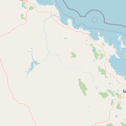
Map view of Newry Islands National Park

Use this park location map to pinpoint Newry Islands National Park in Australia, understand its exact geographic position, and read its mapped placement within the surrounding landscape more clearly.

Pigeon | © OpenStreetMap contributors

Location context for Newry Islands National Park

Queensland
Park atlas

Trace more protected islands and marine conservation landscapes across the Great Barrier Reef region.

Discover Other National Parks Near Newry Islands National Park in Tropical North Queensland

Explore other national parks and protected areas near Newry Islands National Park, tracing a network of coastal islands and marine environments within tropical North Queensland. Compare diverse protected landscapes across the Great Barrier Reef region, revealing broader geographic patterns and interconnected conservation efforts beyond a single park entity.
Marine protected areaQueensland
Park boundaries overlap#1 closest

North

Great Barrier Reef Marine Park: Atlas and Geographic Context for Queensland Protected Waters

Exploring the reef system and marine conservation zones in northeastern Australia

The Great Barrier Reef Marine Park stands as an internationally significant marine protected area. By spanning a massive stretch of the Queensland coast, this protected landscape provides a critical framework for marine governance and reef conservation. Users can examine the unique zoning and distribution of coral reef habitats that define this extensive tropical ecosystem.

Area
343,966 km²
Established
1975
Climate
Tropical
Scope
Marine
National parkQueensland
3.1 km away#2 closest

Southeast

Cape Hillsborough National Park: Queensland's Volcanic Peninsula National Park

Mapped geography and protected landscape context in Central Queensland.

Cape Hillsborough National Park is a notable protected area defined by its unique volcanic peninsula landform in Queensland. Its rugged terrain features dense rainforest interiors that contrast with the surrounding coastal environments and tidal zones. As a national park, it offers an excellent opportunity to study landscape context, mapped geological features, and the distribution of protected natural areas within the Central Queensland region.

Area
10.22 km²
Established
1985
IUCN
II
Relief
Upland
National parkQueensland
11 km away#3 closest

South

Pioneer Peaks National Park: Queensland National Park Geography and Mapped Boundaries

Explore its protected landscape and regional context.

Pioneer Peaks National Park represents a distinct protected area within Queensland, Australia, offering valuable insights into regional geography and mapped natural landscapes. This canonical page focuses on the park's identity as a national park, detailing its geographic setting and the significance of its protected boundaries. It serves as a crucial point for understanding its place within the Australian atlas and the broader context of conservation landscapes.

Area
18.4 km²
Established
1992
IUCN
II
Relief
Mountain
National parkQueensland
14 km away#4 closest

Southwest

Mount Ossa National Park: A Protected Landscape within Queensland's Natural Atlas

Discover its mapped boundaries and regional geographic context.

Mount Ossa National Park stands as a key protected entity within Queensland, Australia, offering rich opportunities for atlas-based exploration. This page details its designation as a national park and provides context for its mapped landscape, allowing for a deeper understanding of its geographic significance in northeastern Australia. Explore the park's role in the regional conservation effort and its place within the broader Australian protected areas network.

Area
4.96 km²
Established
1994
IUCN
II
Relief
Mountain
National parkQueensland
20 km away#5 closest

West

Eungella National Park: National Park Protected Landscape and Queensland Geography

Explore mapped boundaries and regional landscape context.

Gain a detailed understanding of Eungella National Park as a protected landscape within Queensland. This page focuses on its mapped boundaries and geographic positioning, offering an atlas-oriented view for those interested in regional park discovery. Delve into the specific natural terrain and protected area context that characterizes Eungella National Park, enhancing your geographic comprehension.

Area
517 km²
Established
1941
IUCN
II
Relief
Mountain
National parkQueensland
23 km away#6 closest

South

Mount Martin National Park: A Protected National Park in Queensland's Natural Landscape

Explore its mapped boundaries and regional geographic context.

Mount Martin National Park represents a distinct protected area within the Australian state of Queensland. This page offers focused insight into its role as a national park, providing users with a clear understanding of its geographic setting and mapped boundaries. Delve into the specific landscape characteristics and conservation context that define Mount Martin National Park, enriching your atlas exploration of Queensland's protected regions.

Area
4.76 km²
Established
1994
IUCN
II
Relief
Mountain
National parkQueensland
23 km away#7 closest

North

Repulse Island National Park: Queensland's Coastal Protected Area and Mapped Geography

Explore this key national park's mapped boundaries and island landscape.

Repulse Island National Park is an important protected natural area offering unique insights into coastal island geography within Queensland's expansive conservation network. Established as a national park, it signifies a commitment to preserving representative natural landscapes. This page focuses on the mapped boundaries, regional geographic context, and the protected landscape identity of Repulse Island National Park, providing a detailed entry point for atlas-driven discovery of Australia's protected areas.

Area
1.51 km²
Established
1994
IUCN
II
Scope
Terrestrial
National parkQueensland
24 km away#8 closest

Southeast

Reliance Creek National Park: Preserving Queensland's Coastal Palm Forest Ecosystem

Mapped protected landscape on Queensland's central coast.

Reliance Creek National Park is a critical conservation site in Queensland, safeguarding the most significant remaining area of coastal palm forest. This compact national park protects a unique subtropical ecosystem that has largely vanished from the surrounding regional landscape. Users can explore its precise location and geographic context, understanding its importance as a preserved natural heritage and a testament to the original coastal plain environment.

Area
0.14 km²
Established
1980
IUCN
II
Access
Remote access

Common questions about visiting, size, designation, and location context for Newry Islands National Park

Newry Islands National Park FAQs for park facts, access, geography, and protected area context

Find quick answers about Newry Islands National Park, including protected-area facts, park geography, trail and visitor context, and how the park fits into its surrounding country and regional landscape.
MoriAtlas Explorer

Continue Your Protected Areas Search Across the Global Atlas

Deepen your exploration by continuing the structured search for national parks and protected areas worldwide. Utilize the comprehensive filtering capabilities to compare different conservation landscapes and refine your understanding of global park geography. Discover more about the distribution and characteristics of protected natural areas.

Global natural geography