Mori Atlas logo
National parkNorth Cascades National Park

Discover the mapped boundaries and natural terrain of this key US National Park.

North Cascades National Park: Mapping Its Protected Landscape and Regional Geography in Washington

North Cascades National Park stands as a significant protected area within Washington, offering a rich landscape for geographic exploration and atlas-based discovery. This page focuses on understanding the park's defined protected boundaries and its unique position within the regional geography of the Pacific Northwest. Delve into the mapped terrain and natural context that define this important US National Park, providing essential data for anyone interested in protected lands and their landscape identity.

Alpine WildernessGlaciersOld-Growth ForestMountain PeaksWildernessBiodiversity

North Cascades National Park

National park

Park overview

Structured park overview, official facts, and landscape profile for North Cascades National Park

North Cascades National Park park facts, protected area profile, and essential visitor context

Review the core facts for North Cascades National Park, including designation, size, terrain, visitor scale, habitats, and operating context in one park-focused overview.

About North Cascades National Park

North Cascades National Park preserves one of the most spectacular and ecologically significant mountain wilderness areas in the United States. The park's landscape represents some of the steepest terrain in the contiguous United States, where erosion from water and glacial ice has created dramatic relief between western valleys at around 400 feet above sea level and peaks exceeding 9,200 feet. The geological foundation of the North Cascades differs fundamentally from the southern Cascade Range, consisting primarily of ancient Mesozoic crystalline and metamorphic rocks rather than the younger volcanic formations found to the south. This geological complexity creates a complex puzzle of formations that has puzzled geologists and represents one of the least understood geological records in North America. The park's remote and rugged character, combined with heavy snowfall and high avalanche risk, has limited human development and preserved an almost entirely wilderness character that offers visitors profound solitude and connection with natural landscapes unchanged by modern development.

Quick facts and research context for North Cascades National Park

Located in Whatcom, Skagit, and Chelan counties in Washington State, North Cascades National Park was established on October 2, 1968. The park is managed as part of the North Cascades National Park Complex, which also includes Ross Lake and Lake Chelan National Recreation Areas. Nearly the entire park is designated as the Stephen Mather Wilderness, protecting 93 percent of its 504,654 acres as wilderness where human alteration is prohibited. The park features over 300 glaciers, more than 500 lakes and ponds, and serves as the headwaters for the Skagit River, Stehekin River, and Nooksack River.

Protection and recognition

Exploring the terrestrial framework and historical designation records since 1968

North Cascades National Park Protection Status and Designation

Researchers and conservation enthusiasts can examine the official terrestrial protection framework established for North Cascades National Park. Documented designation details dating back to 1968 clarify how the vast wilderness fits into regional conservation frameworks.

Protection details

Protection scope
Terrestrial
Designated year
1968
Transboundary protection
No
Park context

Deeper park guide and search-rich context for North Cascades National Park

North Cascades National Park history, landscape, wildlife, and travel context

Explore North Cascades National Park through its history, landscape character, ecosystems, wildlife, conservation priorities, cultural context, and seasonal travel timing in a structured park guide built for atlas discovery and search intent.

Why North Cascades National Park stands out

North Cascades National Park is best known for its exceptional glacial landscape, which contains the largest concentration of glaciers in the contiguous United States with over 300 ice bodies. The park protects the most extensive glacial system in the lower 48 states, representing roughly one-third of all glaciers outside Alaska. It is also renowned for its extraordinary biodiversity, hosting the highest flora diversity of any American national park with 1,630 documented vascular plant species and extensive old-growth forests spanning 236,000 acres. The dramatic mountain scenery, including peaks like Goode Mountain, Mount Shuksan, and the jagged Picket Range, combined with nearly 400 miles of hiking trails, makes it a premier wilderness destination.

North Cascades National Park history and protected-area timeline

Human presence in the North Cascades dates back 8,000 to 10,000 years, beginning with Paleo-Indians advancing from Puget Sound as glacial ice retreated. Archaeological evidence at Cascade Pass has revealed microblades nearly 9,600 years old, among 260 prehistoric sites identified within the park. When European explorers arrived in the late 18th century, an estimated thousand Skagit people inhabited the region, living in large communal lodges and practicing potlatch ceremonies. The fur trade brought Alexander Ross to the area in 1814, establishing Fort Okanogan, the first American settlement in present-day Washington. Limited mining and logging occurred from the late 19th century, while dam construction in the 1920s along the Skagit River for hydroelectric power prompted environmental advocates to campaign for wilderness preservation. After decades of advocacy, North Cascades National Park was finally established on October 2, 1968, with much of the park designated as the Stephen Mather Wilderness by 1988.

North Cascades National Park landscape and geographic character

The physical landscape of North Cascades National Park is defined by its spectacular mountain terrain, with Goode Mountain rising as the park's highest point at 9,220 feet. The southern section contains several peaks exceeding 9,000 feet, including Buckner Mountain, Mount Logan, and Black Peak, while the northern Picket Range features dramatic spires with ominous names like Mount Fury, Mount Challenger, and Mount Terror. The park contains over 300 glaciers representing the most extensive glacial system in the contiguous United States, with Boston Glacier being the largest at 1,730 acres. More than 500 lakes and ponds dot the landscape, while hundreds of creeks and streams carry glacial meltwater, often appearing turquoise due to suspended rock particles called glacial flour. The Skagit River bisects the park, flowing through Ross Lake National Recreation Area and supplying nearly 90 percent of Seattle's electricity through dams in the watershed.

North Cascades National Park ecosystems, habitats, and plant life

The ecological diversity of North Cascades National Park is remarkable, with eight distinct life zones supporting extraordinary biodiversity across its nearly 9,000-foot elevation range. The park contains 1,630 documented vascular plant species, the highest count of any American national park, with estimates suggesting that adding non-vascular plants and fungi could more than double this number. Approximately 236,000 acres of old-growth forests remain largely untouched, with virgin stands of western hemlock, red cedar, and Douglas fir dominating lower elevations up to the timberline at 7,000 feet. At higher elevations, Pacific silver fir dominates, transitioning to mountain hemlock, then giving way to subalpine meadows and finally sparse alpine vegetation. Whitebark pine grows at the highest elevations in the drier eastern region, providing critical habitat for species like Clark's nutcracker and Douglas squirrels. Climate change and invasive species pose ongoing threats to this ecological richness.

North Cascades National Park wildlife and species highlights

North Cascades National Park supports remarkable animal diversity, with 75 mammal species, more than 200 bird species, at least 28 fish species, and numerous reptiles and amphibians documented within its boundaries. The park provides critical habitat for several threatened and endangered species, including the gray wolf listed as endangered and the grizzly bear listed as threatened, though grizzly bears were extirpated from the region by 1860 and restoration efforts remain underway. Among the 18 carnivore species present are coyote, bobcat, Canada lynx, cougar, American black bear, and the elusive wolverine, one of the rarest mammals in North America. Mountain goats thrive on the steep snow-covered slopes, while elk and moose inhabit the valleys. The park's waterways support all five species of Pacific salmon, making it ecologically significant for marine species that depend on freshwater habitats. Birdlife includes bald and golden eagles, northern spotted owl, harlequin duck, and the federally endangered peregrine falcon.

North Cascades National Park conservation status and protection priorities

North Cascades National Park represents one of the most significant conservation designations in the contiguous United States, protecting an ecosystem with extraordinary biodiversity and geological value. The park's designation as wilderness across 93 percent of its area provides the highest level of federal protection, prohibiting logging, mining, oil and gas extraction, and other extractive activities. The park hosts one of the earliest and longest-running research programs dedicated to studying climate change, primarily through examining glacial retreat and its effects on ecosystems and water resources. Research has documented a 40 percent reduction in glacial ice volume since the end of the Little Ice Age, with a 25 percent reduction in summer streamflow since 1959, making the park a critical indicator of climate impacts in mountain ecosystems. The park also maintains an ongoing fish stocking program, unique among national parks, allowing non-reproducing fish in a limited number of lakes.

North Cascades National Park cultural meaning and human context

The North Cascades region has been inhabited by Native peoples for thousands of years, with the Skagit people historically residing primarily west of the park near Puget Sound and venturing into the mountains during summer months. Inland tribes including the Nlaka'pamux, Chelan, Okanogan, and Wenatchee lived partly or year-round in the eastern sections. These peoples left a rich archaeological record spanning five distinct cultural periods, with evidence of chert mining from Hozomeen Mountain near the park's eastern border extending back 8,400 years. The region's history also includes the early fur trade era, with Fort Okanogan established in 1811 as a trading post, and later Anglo-European exploration in the 1850s and 1880s that sought potential railroad routes through the mountains.

Top sights and standout views in North Cascades National Park

North Cascades National Park offers exceptional wilderness experiences through nearly 400 miles of hiking trails, including 18 miles of the Pacific Crest Trail and 63 miles of the Pacific Northwest Trail. Cascade Pass, used as a travel route by Native Americans for thousands of years, remains one of the most popular destinations. The park provides premier mountaineering opportunities with high-quality climbing routes on numerous peaks including Forbidden Peak, one of the Fifty Classic Climbs of North America. Unlike most national parks, there are no drivable campgrounds within the park itself; all overnight camping is backcountry camping requiring permits, preserving the wilderness character and solitude. Mount Shuksan in the northwest corner, at 9,131 feet, is among the most photographed peaks in the region and is accessible via trails in adjacent national forests.

Best time to visit North Cascades National Park

The best time to visit North Cascades National Park is from mid-June through late September when high elevation trails are accessible and weather is most stable. Summer months bring the warmest temperatures, particularly on the drier eastern slopes where highs can reach 90°F. Peak visitation occurs between June and September. Winter conditions are extreme, with State Route 20, the only highway through the park complex, typically closed from late November until late April due to heavy snowfall and avalanche danger. The western slopes receive over 400 inches of snow annually at higher elevations, creating dangerous conditions but also preserving the exceptional glacial landscape. Spring and fall offer fewer crowds but unpredictable weather, with fall often bringing clear skies and comfortable temperatures.
Park guides

Targeted answers for exploring glacial terrain and mountain wilderness

North Cascades National Park Focused Guides and Expert Visit Planning

Selected published resources provide focused insights into complex mountain terrain and remote wilderness conditions. Detailed coverage addresses essential visit planning questions regarding optimal seasonal access for high-elevation trails.
Monthly climate preview

Long term temperature and precipitation normals for Washington's alpine wilderness

Climatological Profiles and Weather by Month for North Cascades National Park

Long term climate normals at a representative elevation of 1228 meters show a steep transition from cold, wet winter months to drier, milder conditions in July and August. Comparing the monthly precipitation averages and temperature limits helps map the seasonal rhythm of the protected mountain environment in Washington.
Annual mean3 °C
-5 °C14 °C
Jan-5°
Feb-5°
Mar-3°
Apr
May
Jun10°
Jul13°
Aug14°
Sep10°
Oct
Nov-2°
Dec-5°
Warmest month
August

13.5 °C

Coolest month
December

-5.5 °C

Wettest month
November

8.3 mm/day

Driest month
August

1.6 mm/day

Park location guide

Geography guide, regional context, and park location map for North Cascades National Park

North Cascades National Park park geography, regions, and map view in United States of America

Understand where North Cascades National Park sits in United States of America through a broader geographic reading of the surrounding landscape, nearby location context, and its mapped position within the national park landscape.

How North Cascades National Park fits into United States of America

The United States of America is a federal presidential republic and one of the world's largest countries by area and population. It consists of 50 states across a vast territory spanning multiple time zones, with its capital in Washington, D.C. and largest city in New York City. The nation has a diverse economy, influential political system, and significant cultural and military presence globally.

Wider geography shaping North Cascades National Park in United States of America

The United States occupies a vast territory in North America, bordered by Canada to the north and Mexico to the south. The 48 contiguous states stretch from the Atlantic to the Pacific Ocean, while Alaska occupies the northwestern region and Hawaii is an archipelago in the Pacific. The country encompasses diverse terrain including the Rocky Mountains, Appalachian Mountains, Great Plains, and extensive river systems.

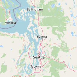
Map view of North Cascades National Park

Use this park location map to pinpoint North Cascades National Park in United States of America, understand its exact geographic position, and read its mapped placement within the surrounding landscape more clearly.

Pigeon | © OpenStreetMap contributors

Location context for North Cascades National Park

Washington
Natural feature types

Explore Named Natural Features Within North Cascades National Park

Continue your geographic exploration of North Cascades National Park by browsing its significant natural landmarks. MoriAtlas organizes these glaciers, peaks, and water bodies to help you better understand the complex physical terrain and regional landscape context of this protected wilderness.
Recorded earthquake history

Explore Recorded Earthquake History for North Cascades National Park

Review the historical catalogue of seismic activity surrounding the peaks and glaciers of North Cascades National Park. This MoriAtlas resource consolidates recorded earthquake data, allowing you to examine regional magnitude, depth, and distance patterns across the park landscape.

North Cascades National Park Earthquake History

Catalogued events

61 events

Strongest magnitude

Magnitude 5

Most recent event

Apr 28, 2023

This history includes earthquakes recorded inside the park or within 50 km of its borders

Park atlas

Browse adjacent national park geography and surrounding protected landscapes within the North Cascades region.

Discover Related National Parks and Protected Areas Surrounding North Cascades National Park in Washington State

After exploring North Cascades National Park, browse a curated list of national parks and significant protected areas located nearby in the Pacific Northwest region. Compare these diverse conservation landscapes, map their geographic spread, and trace connections across alpine wilderness, glacial terrain, and old-growth forest ecosystems.
Wildlife reserveWashington
Park boundaries overlap#1 closest

South

Glacier Peak Wilderness: Mapping the Volcanic and Glaciated Geography of Washington State

A detailed look at one of the most remote volcanic reserves in the Cascade Range.

Defined by the presence of an isolated stratovolcano and extensive glacial systems, Glacier Peak Wilderness represents a significant protected area within the Washington Cascades. This overview details the rugged landscape, from the deeply incised river valleys of the Chiwawa and Suiattle to the high-alpine rock and ice environment at the peak summit, providing essential geographic context for this roadless wilderness.

Area
2,290.75 km²
Established
1960
IUCN
Ib
Relief
Mountain
Protected landscapeChelan County
Park boundaries overlap#2 closest

Southeast

Lake Chelan National Recreation Area: Protected Geography and North Cascades Map

Glacial terrain and remote mountain valleys in Chelan County

Lake Chelan National Recreation Area protects a rare transition of alpine environments and river-carved valleys in north-central Washington. The terrain is dominated by the long, deep waters of the lake and the steep ridges of the North Cascades, creating an isolated habitat for wild landscapes and historic inland communities. Explore the physical boundaries and topographic features that define this rugged recreation area.

Area
250.74 km²
Established
1968
IUCN
V
Visitors
38.2K annual
Wildlife reserveWashington
Park boundaries overlap#3 closest

Southeast

Lake Chelan-Sawtooth Wilderness: Geographic Atlas and Protected Landscape Overview

North Cascades Wilderness in Washington State

Located in the north-central Cascade Range of Washington, this protected wilderness area contains 63 glacial lakes and extensive alpine terrain. The region offers a complex landscape of cirques, subalpine meadows, and forested valleys that connect directly to the larger North Cascades protected network. Use this atlas to examine its mountainous geography and defined conservation boundaries.

Area
619.4 km²
Established
1984
IUCN
Ib
Relief
Mountain
Protected landscapeWashington
Park boundaries overlap#4 closest

South

Mount Baker, Snoqualmie National Forest: Mapped Geography and Protected Landscape Analysis

Exploratory atlas of Washington's primary Cascade Range wilderness

Delve into the structural geography of Mount Baker, Snoqualmie National Forest. This protected area corridor serves as a major ecological transition zone between the Puget Sound lowlands and the interior Cascades, characterized by extensive glaciers, wild river systems, and iconic stratovolcanoes that define the regional landscape of Washington state.

Area
6,978 km²
Established
1974
Relief
Mountain
Climate
Alpine
Wildlife reserveWashington
Park boundaries overlap#5 closest

West

Mount Baker Wilderness: Mapped Volcanic Peaks and Glacial Geography in Washington State

Protected wilderness boundaries in the Northern Cascades

Mount Baker Wilderness encompasses a vast mountain landscape characterized by an active stratovolcano and significant permanent snowfields. The terrain features a vertical gradient from dense west side conifer forests to exposed alpine summits, creating a distinct ecological corridor connected to neighboring protected areas in the Pacific Northwest.

Area
485.58 km²
Established
1984
IUCN
Ib
Relief
Mountain
Protected landscapeWashington
Park boundaries overlap#6 closest

Southeast

Okanogan, Wenatchee National Forest: A Comprehensive Look at Washington's Protected Mountain Landscapes

Mapping ecological gradients and wilderness boundaries across the eastern Cascade Range

Spanning from the moist coniferous forests of the western Cascades to the arid plateaus of the Okanogan, this massive national forest protects an unmatched diversity of terrain. Explore the intricate geography of river-carved valleys, glacial cirques, and remote wilderness areas that characterize this critical environmental corridor in the Pacific Northwest.

Area
6,066.33 km²
Established
1911
Visitors
397K annual
Relief
Mountain
Protected landscapeWashington
Park boundaries overlap#7 closest

Southeast

Ross Lake National Recreation Area: A Glacial Reservoir Landscape in Washington

Mapping the Skagit River and North Cascades alpine corridor

Located in the heart of Washington, Ross Lake National Recreation Area preserves a unique landscape of connected reservoirs and deep, glacier-cut valleys. This protected area acts as a vital geographic link within the North Cascades, offering access to high-altitude peaks, riverine forests, and the distinct turquoise waters of Diablo Lake.

Area
475.81 km²
Established
1968
IUCN
V
Visitors
998K annual
State or regional parkBritish Columbia
6.9 km away#8 closest

Northeast

E. C. Manning Provincial Park: A Comprehensive Geographic Atlas and Protected Area Overview

Mountainous terrain and ecological transitions in southern British Columbia

Spanning the cross section of the Canadian Cascades, E. C. Manning Provincial Park preserves a high-elevation landscape of wildflowers, glacial valleys, and mountain ridges. The protected area links temperate coastal rainforests with the arid interior, providing a study in regional hydrology and subalpine ecology defined by the Hozameen Range and the northern reaches of the Pacific Crest Trail.

Area
836.71 km²
Established
1941
IUCN
II
Visitors
1.1M annual

Common questions about visiting, size, designation, and location context for North Cascades National Park

North Cascades National Park FAQs for park facts, access, geography, and protected area context

Find quick answers about North Cascades National Park, including protected-area facts, park geography, trail and visitor context, and how the park fits into its surrounding country and regional landscape.
MoriAtlas Explorer

Continue Your Protected Areas Search Across the Global Atlas

Deepen your exploration by continuing the structured search for national parks and protected areas worldwide. Utilize the comprehensive filtering capabilities to compare different conservation landscapes and refine your understanding of global park geography. Discover more about the distribution and characteristics of protected natural areas.

Global natural geography