Mori Atlas logo
National parkNowendoc National Park

Atlas exploration of mapped boundaries and natural terrain within this Australian national park.

Nowendoc National Park: Protected Landscape and Geographic Context in New South Wales

Nowendoc National Park represents a significant protected area within the diverse geography of New South Wales, Australia. This park offers a focal point for understanding mapped natural landscapes and their regional distribution. Through MoriAtlas, explore the precise geographic identity of Nowendoc National Park, its relation to the surrounding terrain, and its role as a protected landscape. Gain structured insights into its protected area status and mapped boundaries.

National parksEucalypt forestsNorthern TablelandsCanyonsWaterfallsRainforest

Nowendoc National Park

National park

Park overview

Structured park overview, official facts, and landscape profile for Nowendoc National Park

Nowendoc National Park park facts, protected area profile, and essential visitor context

Review the core facts for Nowendoc National Park, including designation, size, terrain, visitor scale, habitats, and operating context in one park-focused overview.

About Nowendoc National Park

Nowendoc National Park occupies a significant position in the conservation landscape of northern New South Wales, protecting a diverse range of ecosystems within its 88 square kilometre boundary. The park sits on the southern reaches of the Northern Tablelands, an elevated plateau region characterized by rugged, dissected terrain formed through millions of years of erosion of ancient sandstone and granite bedrock. This geological foundation has created the dramatic landscape of steep escarpments, narrow valleys, and distinctive rock formations that define the park's visual character. The climate of the Northern Tablelands brings cool nights and moderate rainfall, supporting forest ecosystems that differ markedly from the adjacent slopes and plains below. Eucalypt forests dominate the higher ground, their dense canopy providing habitat for a wide variety of native birds and arboreal mammals, while the protected creek valleys harbor more moisture-dependent species in what amounts to ecological refugia within the broader landscape. The park's establishment in 1999 represented the culmination of decades of advocacy by local conservation groups seeking to protect this distinctive landscape from further clearing and development. Today, the park offers visitors a genuine wilderness experience, with limited facilities and access that requires self-sufficiency and appropriate preparation for remote Australian bushland.

Quick facts and research context for Nowendoc National Park

Nowendoc National Park covers approximately 88 square kilometres of mountainous terrain on the Northern Tablelands of New South Wales. The park was officially established in 1999 under the management of the NSW National Parks and Wildlife Service, receiving IUCN Category II protection status. The landscape features deep sandstone canyons, cascading waterfalls, and eucalypt forests that transition to subtropical rainforest in the sheltered creek valleys. Access is challenging, with all roads being gravel and winding, and certain areas requiring four-wheel drive vehicles. The park is divided into two main sections: a larger western area containing the Myall Creek Campground and Callaghans Canyon, and a smaller southeastern section around Wrights Hut that requires a permit and key from park authorities.

Protection and recognition

Documented terrestrial management scope and geographic conservation classification

Nowendoc National Park Protection Status and Conservation Designation

Nowendoc National Park is managed under a dedicated terrestrial protection framework to preserve its distinct geographic features and wilderness values. Reviewing the official conservation scope and designation records helps clarify the park's administrative standing within the wider regional network of protected landscapes.

Protection details

Protection scope
Terrestrial
Transboundary protection
No
Park context

Deeper park guide and search-rich context for Nowendoc National Park

Nowendoc National Park history, landscape, wildlife, and travel context

Explore Nowendoc National Park through its history, landscape character, ecosystems, wildlife, conservation priorities, cultural context, and seasonal travel timing in a structured park guide built for atlas discovery and search intent.

Why Nowendoc National Park stands out

Nowendoc National Park is best known for its spectacular sandstone canyon scenery, particularly Callaghans Canyon, which features dramatic cliff faces and seasonal waterfalls plunging into deep pools. The park protects one of the most intact eucalypt forest ecosystems remaining on the Northern Tablelands, with tall forests of Sydney blue gum, new England stringybark, and narrow-leaved ironbark dominating the ridgelines. The Myall Creek valley supports a remarkable diversity of habitats, transitioning from dry sclerophyll forest on the exposed slopes to lush subtropical rainforest in the protected gorges where ancient cycads and tree ferns thrive. The Barnard River headwaters that flow through the park contain several significant waterfalls accessible to bushwalkers who venture beyond the basic camping area, making this park a destination for experienced hikers seeking remote wilderness experiences.

Nowendoc National Park history and protected-area timeline

The lands now protected within Nowendoc National Park have a human history extending back thousands of years, though the precise Indigenous connections to this particular area are not extensively documented in available sources. European exploration of the Northern Tablelands began in the early nineteenth century, with pastoral settlers establishing runs across the region throughout the 1830s and 1840s. The Nowendoc area remained relatively remote due to its rugged terrain and difficult access, limiting intensive agricultural development compared to other parts of the tablelands. The land that became the national park remained in various private ownerships for much of the twentieth century, with timber getting and limited grazing occurring in different periods. Recognition of the area's conservation significance grew during the 1970s and 1980s as awareness of the importance of protecting remaining old-growth forests and wilderness areas increased across Australia. The park was finally declared in 1999, creating a formal protected area that preserved both the natural values and the increasingly appreciated scenic qualities of this mountainous terrain. The NSW National Parks and Wildlife Service assumed management responsibility, implementing protection measures while allowing controlled public access to the area's wilderness values.

Nowendoc National Park landscape and geographic character

The physical landscape of Nowendoc National Park is defined by its position on the western edge of the Northern Tablelands, where the plateau gives way dramatically to the steep slopes descending toward the Manning River catchment below. The terrain is dominated by rugged sandstone escarpments and ridges, with elevation differences of several hundred metres between the creek valleys and the surrounding hilltops. The park contains several deep canyons carved by water through the sandstone, with Callaghans Canyon being the most prominent and visually spectacular of these geological features. Vertical cliff faces rise above narrow gorge floors, creating microclimates that support moisture-loving plant communities in contrast to the surrounding dry forests. Creeks including Myall Creek and Callaghans Creek have cut deep channels through the landscape, their courses marked by cascades and waterfalls that flow more strongly during the wetter months. The forest canopy is dominated by various eucalypt species that give the landscape its characteristic appearance, with the trees growing tall and straight on the better soils of the slopes and valleys. Outcrops of exposed sandstone add visual interest throughout the park, particularly in the canyon areas where erosion has revealed the layered geological character of the terrain.

Nowendoc National Park ecosystems, habitats, and plant life

The ecological character of Nowendoc National Park reflects its position at the junction of several distinct biogeographic regions, creating a mosaic of habitats within a relatively compact area. The dominant eucalypt forests cover the slopes and ridgelines, dominated by species adapted to the seasonal climate and periodic fire that characterizes the tablelands. These tall open forests support a complex web of native wildlife, from arboreal mammals like greater gliders and koalas to diverse birdlife including cockatoos, rosellas, and honeyeaters. The creek valleys contain a fundamentally different ecological community, where increased moisture and protection from wind support subtropical rainforest elements. Ancient plant lineages such as cycads and tree ferns occur in these sheltered gorges, representing remnants of vegetation types that were more widespread during wetter periods of Australia's geological history. The headwater streams of the Barnard River system contain their own aquatic ecology, with native fish and invertebrate species adapted to the clear, cool, seasonal flows. The combination of forest types, the presence of flowing water, and the varied topography creates a surprisingly biodiverse environment considering the park's relatively modest size.

Nowendoc National Park wildlife and species highlights

The wildlife of Nowendoc National Park is characteristic of the Northern Tablelands eucalypt forests, though the varied habitat types support a range of species from different ecological groups. The tall eucalypt forests provide essential habitat for koalas, which persist in significant numbers in some areas of the park despite the pressures that have reduced populations elsewhere in Australia. Greater gliders, also arboreal marsupials, are present in the older forest stands, using their large gliding membranes to move between trees in the canopy. Birdlife is particularly diverse, with sulphur-crested cockatoos, gang-gang cockatoos, and various rosella species among the more commonly observed parrots. Australian king-parrots and eastern rosellas add splashes of colour to the forest environment, while lyrebirds scratch through the leaf litter on the forest floor. Reptiles including various skink species and occasionally snakes are present in the drier forest areas, while amphibians favour the creek environments where moisture is more constant. The streams themselves support native fish species adapted to the cool, clear waters of the tablelands, completing an ecosystem that ranges from the forest canopy down to the aquatic environment of the headwater creeks.

Nowendoc National Park conservation status and protection priorities

Nowendoc National Park contributes significantly to the conservation of Northern Tablelands ecosystems, protecting one of the relatively few remaining areas of intact forest in a region that has been extensively modified by pastoral and agricultural development. The park preserves both the upland eucalypt forests and the restricted rainforest communities that occur in the protected gorges, representing habitat types that have declined substantially across their former range. Protection of the Barnard River headwaters is particularly important, as these streams feed into broader river systems downstream, making the park's conservation role extend beyond its boundaries to encompass catchment-scale ecological function. The isolated nature of the park and the challenging access have actually benefited conservation outcomes by limiting the pressure from heavy visitor use that affects more accessible protected areas. Management focuses on maintaining the natural values while allowing appropriate low-impact recreational use, with particular attention to managing fire to protect both life and property while maintaining the ecological role of fire in the eucalypt forest ecosystem.

Nowendoc National Park cultural meaning and human context

The cultural context of Nowendoc National Park includes both Indigenous heritage and the more recent pastoral history that shaped the European settlement of the Northern Tablelands. The traditional lands of the Birrip people extended across this area of New South Wales, though specific connections to the Nowendoc landscape are not extensively documented in available sources. European settlement brought pastoral runs to the tablelands from the 1830s onward, with the rugged terrain around Nowendoc remaining less intensively developed than more accessible neighbouring areas. Remnants of early European use may exist in the park, though the focus of heritage management is primarily on preserving natural values rather than built heritage. The small community of Nowendoc itself, located near the park's eastern boundary, provides a limited service centre for visitors, though most supplies would be obtained in larger towns like Walcha or further afield. The relationship between the local community and the national park continues to evolve as the park becomes better known and visitor numbers gradually increase.

Top sights and standout views in Nowendoc National Park

Nowendoc National Park offers several standout features that distinguish it from other protected areas on the Northern Tablelands. Callaghans Canyon provides the park's most dramatic scenery, with its sheer sandstone walls and seasonal waterfalls creating a spectacular natural display that rewards visitors who make the effort to reach it. The Myall Creek Campground offers a genuine back-to-basics camping experience in tall eucalypt forest, appealing to those who prefer minimal infrastructure and self-sufficient outdoor recreation. The network of walking tracks through the park leads to hidden waterfalls and scenic lookouts that remain relatively unknown compared to more famous national parks, preserving a sense of discovery for adventurous visitors. The combination of eucalypt forest and subtropical rainforest in close proximity demonstrates remarkable ecological diversity within a small area, with the transition between these distinct vegetation types visible along watercourses. Four-wheel drive enthusiasts find the park's challenging access part of its appeal, with the remote Wrights Hut area offering a more rugged experience for those with appropriate vehicles and skills.

Best time to visit Nowendoc National Park

The optimal time to visit Nowendoc National Park depends on what visitors hope to experience, though the cooler months from late autumn through winter into early spring generally offer the most comfortable conditions for exploring the park. Winter brings crisp, clear days with minimal rainfall in most years, making the walking tracks more accessible and the forest scenery particularly attractive as morning mist fills the valleys. The waterfall flows are heavily dependent on recent rainfall, so visiting after good seasonal falls will produce the most impressive displays at Callaghans Canyon and other cascades throughout the park. Summer months can bring hot conditions on the exposed ridgelines, though the forest valleys offer some protection from extreme temperatures. The park is accessible year-round, though wet weather can make the gravel roads treacherous and may close the more remote sections. Visitors should be aware that the camping facilities are basic and that the park receives relatively few visitors compared to more famous destinations, meaning that the experience is genuinely wilderness-oriented rather than developed tourism.
Monthly climate preview

Trace long-term representative temperature and monthly precipitation patterns across the protected landscape

Nowendoc National Park Climate Normals and Annual Temperature Rhythm

Representative coordinate records show average temperatures ranging from cool winter lows near freezing to warm summer peaks, alongside recorded monthly precipitation rates. Opening the complete climate profile reveals full twelve-month statistical distributions for detailed regional comparison.
Annual mean15 °C
8 °C21 °C
Jan21°
Feb20°
Mar18°
Apr15°
May11°
Jun
Jul
Aug
Sep12°
Oct15°
Nov18°
Dec20°
Warmest month
January

21.1 °C

Coolest month
July

8 °C

Wettest month
February

4.9 mm/day

Driest month
July

1.5 mm/day

Park location guide

Geography guide, regional context, and park location map for Nowendoc National Park

Nowendoc National Park park geography, regions, and map view in Australia

Understand where Nowendoc National Park sits in Australia through a broader geographic reading of the surrounding landscape, nearby location context, and its mapped position within the national park landscape.

How Nowendoc National Park fits into Australia

Australia is a constitutional monarchy and federal parliamentary democracy comprising six states and ten territories. With a population of nearly 28 million, it is one of the world's most urbanised countries, with most people concentrated on the eastern seaboard. The country has a high Human Development Index and is known for its cultural diversity, ancient Aboriginal heritage, and unique wildlife.

Wider geography shaping Nowendoc National Park in Australia

Australia occupies the entire Australian continent, the island of Tasmania, and numerous smaller islands. It is the world's flattest and driest inhabited continent, featuring vast deserts in the interior (the Outback), tropical rainforests along the eastern coast, and a coastline bordering the Indian and Pacific Oceans.

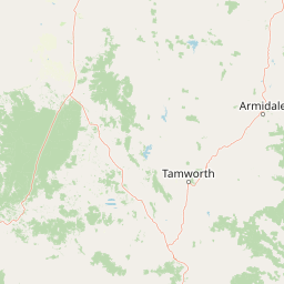
Map view of Nowendoc National Park

Use this park location map to pinpoint Nowendoc National Park in Australia, understand its exact geographic position, and read its mapped placement within the surrounding landscape more clearly.

Pigeon | © OpenStreetMap contributors

Location context for Nowendoc National Park

New South Wales
Park atlas

Compare surrounding protected landscapes and trace the wider park geography of the Northern Tablelands.

Explore National Parks and Protected Areas Near Nowendoc National Park, New South Wales

After exploring Nowendoc National Park's rugged escarpments and deep canyons, discover other national parks and protected areas across the Northern Tablelands of New South Wales. Compare the diverse eucalypt forests, unique canyon systems, and conservation landscapes that define this distinct Australian geographic region.
National parkNew South Wales
8.4 km away#1 closest

Southeast

Barakee National Park: New South Wales Protected Landscape Atlas Explorer

Mapped Boundaries and Regional Geography Insights

Barakee National Park is a vital component of New South Wales's protected natural areas, offering a focused point for geographic discovery. This page provides key details on its protected landscape identity and its place within the mapped terrain of the region. Examine the structured data to grasp the park's geographic footprint and understand its significance as a designated national park within Australia.

Area
50.11 km²
Established
1999
IUCN
II
Relief
Mixed relief
National parkNew South Wales
11 km away#2 closest

Southeast

Woko National Park: Explore Its Protected Landscape and Geographic Boundaries

Discover the mapped terrain and regional atlas context of Woko National Park.

Woko National Park presents a unique opportunity for geographic discovery, situated within New South Wales, Australia. This detail page focuses on the park's protected landscape and its mapped boundaries, providing a clear understanding of its geographic identity. Engage with Woko National Park as a key component of the Australian national park atlas, highlighting its regional setting and natural terrain.

Area
85.98 km²
Established
1982
IUCN
II
Relief
Highland
National parkNew South Wales
16 km away#3 closest

Northeast

Mummel Gulf National Park: New South Wales Protected Area & Mapped Gorge Landscape

Rugged escarpment terrain with diverse forest ecosystems.

Mummel Gulf National Park is a protected area in New South Wales, Australia, renowned for its dramatic V-shaped gorge carved by the Mummel River, reaching depths over 400 metres. This rugged escarpment landscape hosts a variety of vegetation communities, including tall open eucalypt, wet sclerophyll, snow gum forests, and subtropical rainforest patches. The park's geography is central to its ecological significance, providing habitat for numerous species and showcasing a distinct natural terrain within the New England region, ideal for geographic exploration.

Area
122 km²
Established
1999
IUCN
II
Relief
Mountain
Nature reserveNew South Wales
About 21 km away#4 closest

Southeast

Bretti Nature Reserve: Geography and Protected Escarpment Landscapes in New South Wales

Mapped riverine corridors and wet forest ecosystems

Bretti Nature Reserve serves as a vital conservation anchor in the Hunter Region, protecting a rare mix of subtropical rainforest and wet sclerophyll forest. This detailed record maps the reserve's position along the Bernard River, illustrating its role as a landscape-scale link within the Great Eastern Escarpment's diverse mountain terrain.

Area
29.02 km²
Established
1999
IUCN
Ia
Relief
Mountain
National parkNew South Wales
23 km away#5 closest

West

Ben Halls Gap National Park: Ancient Eucalyptus Forest Protected Landscape in New South Wales

Explore mapped boundaries of old-growth woodland terrain.

Ben Halls Gap National Park represents an ecologically vital strict nature reserve within New South Wales, Australia. It is distinguished by its extensive ancient eucalyptus forests, which are among the most ecologically significant old-growth woodland environments in eastern Australia. Managed primarily for conservation and research, the park's rugged terrain provides a critical habitat refuge and a key reference ecosystem for understanding undisturbed woodland dynamics and biodiversity.

Area
30.18 km²
Established
1995
IUCN
Ia
Scope
Terrestrial
Protected areaNew South Wales
25 km away#6 closest

South

Barrington Tops State Conservation Area: Protected Plateau and Volcanic Landscape Context

Highland geography within the Mount Royal Range, New South Wales

This protected area represents a significant upland region in New South Wales, characterized by weathered plateau edges and cool mountain environments. The terrain supports high-altitude peat wetlands and diverse montane forests, rooted in the ancient geological legacy of the Barrington Volcano. Its protected boundaries link directly to the Gondwana Rainforests, providing essential habitat continuity across the Great Dividing Range.

Area
84.46 km²
Established
2003
Relief
Mountain
Climate
Temperate
National parkNew South Wales
31 km away#7 closest

East

Cottan-Bimbang National Park: A Protected Landscape in New South Wales

Explore its mapped boundaries and regional geographic context.

Delve into the protected landscape of Cottan-Bimbang National Park, a key national park situated in New South Wales, Australia. This page provides detailed insight into its geographic setting and mapped park boundaries, offering a clear understanding of its regional importance. Discover the distinct natural landscape characteristics that define Cottan-Bimbang National Park within the broader Australian atlas.

Area
269 km²
Established
1999
IUCN
II
Climate
Temperate
Watercolor illustration of a river flowing through hills with distant mountains and pink trees
National parkNew South Wales
32 km away#8 closest

South

Barrington Tops National Park: A Protected National Park in New South Wales

Explore ancient Gondwana rainforests and dramatic volcanic terrain.

Barrington Tops National Park represents a significant protected landscape in New South Wales, Australia, offering a deep dive into diverse ecosystems. Its unique altitudinal vegetation gradient supports the southernmost subtropical rainforests in Australia and showcases geological formations dating back millions of years. This park is crucial for understanding Australia's natural heritage, providing a rich context for landscape exploration and the study of ancient flora within a mapped geographic setting.

Area
765.12 km²
Established
1969
IUCN
Ib
Relief
Mountain

Common questions about visiting, size, designation, and location context for Nowendoc National Park

Nowendoc National Park FAQs for park facts, access, geography, and protected area context

Find quick answers about Nowendoc National Park, including protected-area facts, park geography, trail and visitor context, and how the park fits into its surrounding country and regional landscape.
MoriAtlas Explorer

Continue Your Protected Areas Search Across the Global Atlas

Deepen your exploration by continuing the structured search for national parks and protected areas worldwide. Utilize the comprehensive filtering capabilities to compare different conservation landscapes and refine your understanding of global park geography. Discover more about the distribution and characteristics of protected natural areas.

Global natural geography