Mori Atlas logo
National parkNyika National Park

Discover the mapped boundaries and regional geography of this key protected area in southern Africa.

Nyika National Park: Zambia's Premier National Park for Geographic and Protected Landscape Exploration

Nyika National Park stands as a notable protected area within Zambia, offering a unique geographic identity for atlas-based discovery. This national park represents a significant natural landscape whose mapped boundaries and regional context contribute to understanding Zambia's diverse terrain. Explore its unique position within the country's geography and the broader atlas of protected lands.

highland plateaumontane grasslandwildflower seasoncross-border parkremote wildernesscolonial history

Nyika National Park

National park

Park overview

Structured park overview, official facts, and landscape profile for Nyika National Park

Nyika National Park park facts, protected area profile, and essential visitor context

Review the core facts for Nyika National Park, including designation, size, terrain, visitor scale, habitats, and operating context in one park-focused overview.

About Nyika National Park

Nyika National Park in Zambia represents a distinctive corner of highland wilderness that is intimately connected to its larger Malawian neighbour across the Nyika Plateau. The park occupies the western edge of this elevated tableland, which rises prominently above the surrounding lowland terrain and forms one of the most visually striking landscapes in the region. The ecological character of the Zambian section mirrors that of the broader plateau, featuring a mosaic of grasslands, rocky crests, and patches of evergreen forest that shelter a range of species adapted to this high-altitude environment. Unlike the more developed Malawian side with its established tourism infrastructure, the Zambian portion has remained deliberately undeveloped, preserving a sense of remoteness and wilderness that appeals to those seeking a quieter, more intrepid exploration of the plateau. The relationship between the two national parks reflects their shared origins as a single transboundary protected area, and the practical reality of accessing the Zambian park via Malawi means that most visitors experience both sides as part of a single journey through this remarkable highland landscape.

Quick facts and research context for Nyika National Park

Nyika National Park lies in northeastern Zambia on the western edge of the Nyika Plateau, a highland region that straddles the Zambia-Malawi border. The park is the smaller Zambian portion of what was once a unified cross-border reserve established during British colonial administration. Access is possible only via the plateau road that runs through Malawi, meaning visitors from Zambia must enter Malawian territory to reach the park. The area features montane grassland, rocky outcrops, and forest patches within the Southern Rift montane forest-grassland mosaic ecoregion. The sole accommodation is Nyika House, a refurbished colonial-era resthouse now operating as an exclusive wilderness lodge.

Protection and recognition

Examining the documented terrestrial scope, designation framework, and management boundaries.

Nyika National Park Protection Status and Conservation Designations

Nyika National Park operates under a dedicated terrestrial protection framework established to preserve the natural integrity of its unique high-altitude plateau. Detailed records outline the official designation status, boundary management scope, and verified conservation data that define the park's current ecological standing.

Protection details

Protection scope
Terrestrial
Transboundary protection
No
Park context

Deeper park guide and search-rich context for Nyika National Park

Nyika National Park history, landscape, wildlife, and travel context

Explore Nyika National Park through its history, landscape character, ecosystems, wildlife, conservation priorities, cultural context, and seasonal travel timing in a structured park guide built for atlas discovery and search intent.

Why Nyika National Park stands out

Nyika National Park is best known for its dramatic highland setting on the Nyika Plateau, offering sweeping views across one of Zambia's most elevated and scenic landscapes. The park is renowned for its seasonal wildflower displays, particularly from September through April when the grasslands come alive with a diverse array of blooms. The plateau environment, with its distinctive combination of open grassland and montane forest patches, represents one of only two examples of the Southern Rift montane forest-grassland mosaic ecoregion found in Zambia, making it ecologically significant despite its relatively small area.

Nyika National Park history and protected-area timeline

The Nyika Plateau was first protected as a unified reserve during the colonial period when both Zambia and Malawi were under British administration. This cross-border approach to conservation reflected the natural geography of the plateau, which spans the emerging international boundary without regard for the colonial borders being drawn beneath it. Following independence in the 1960s, the reserve was divided between the two newly sovereign nations, with the larger and more developed portion becoming Nyika National Park in Malawi, while the Zambian side retained the same name but on a significantly reduced footprint. The only built infrastructure in the Zambian park is a colonial-era resthouse constructed around 1946, which served for decades as the sole accommodation available in either park. After closing in 1998, the building was refurbished by a private operator and reopened in 2006 as Nyika House, now catering exclusively to pre-booked tour groups. The park's access arrangements remain unique, with the only road into the plateau traversing Malawi, meaning Zambian visitors must cross into neighbouring country to reach their own national park.

Nyika National Park landscape and geographic character

The landscape of Nyika National Park is defined by its position on the Nyika Plateau, a broad, elevated tableland that rises to over 2,000 metres above sea level in places. The terrain consists largely of rolling grassland interspersed with rocky granite outcrops that break the skyline and provide sheltered microhabitats for specialised vegetation. Patches of montane forest occur in the deeper valleys and on shaded slopes, creating a varied mosaic of open and wooded areas. The plateau edge offers dramatic views over the surrounding lower-lying country, with the landscape character changing noticeably as one descends from the highland core. Drainage patterns on the Zambian side feed into streams that ultimately flow toward the Luangwa River system, connecting the plateau environment to broader watershed networks in the region.

Nyika National Park ecosystems, habitats, and plant life

The nature of Nyika National Park is distinguished by its representation of the Southern Rift montane forest-grassland mosaic, an ecoregion that occurs in Zambia only here and in a smaller highland area to the north. This ecological designation reflects the unique combination of elevation, climate, and substrate that characterises the plateau, creating conditions that support plant and animal communities more typical of East African highlands than of the Zambian lowlands. The grasslands support a diverse range of wildflower species that bloom seasonally, while the forest patches contain tree species adapted to the cooler, moister conditions of the highland environment. The park's position on the plateau edge means it sits at an ecological transition zone, with species from both higher and lower elevations potentially occurring within its boundaries.

Nyika National Park wildlife and species highlights

The wildlife of Nyika National Park is characteristic of highland grassland and forest edge habitats in this part of southern Africa. Antelope species including reedbuck and duiker are present in the grassland areas, while the forest patches provide habitat for various small mammal species and a diversity of birdlife. The plateau is known for its populations of zebra and eland, which move across the open grasslands in small herds. The seasonal wildflower displays attract numerous insect species, contributing to the overall biodiversity of the park. While the Zambian side has not been the subject of detailed wildlife surveys comparable to those conducted in the Malawian park, the contiguous nature of the plateau means that many species are shared across the international boundary.

Nyika National Park conservation status and protection priorities

Nyika National Park serves as a critical conservation anchor for one of Zambia's rarest ecoregions. The Southern Rift montane forest-grassland mosaic is poorly represented within Zambia's protected area network, making the park's inclusion of this habitat type significant for national biodiversity conservation. The highland environment supports species with limited distributions, and the relatively intact condition of the plateau grassland adds to the conservation value. The transboundary nature of the broader plateau ecosystem, while now divided between two national parks, still functions ecologically as a single unit, and the Zambian portion plays an essential role in maintaining the integrity of this highland landscape. The low-intensity tourism model employed on the Zambian side, centred on the exclusive-use Nyika House, further supports conservation by limiting visitor impacts while generating economic value that motivates continued protection.

Nyika National Park cultural meaning and human context

The cultural context of Nyika National Park is shaped by its colonial origins and its cross-border geography. The plateau was historically inhabited by various local communities whose traditional land uses contributed to the open grassland character of the landscape through controlled burning and pastoralism. During the colonial period, the area wasset aside for protection, and the establishment of the resthouse reflects the administrative priorities of the time. Today, the park's location on an international boundary adds a distinctive dimension to the visitor experience, as travel to the Zambian park necessarily involves crossing into Malawi. This unusual arrangement reflects the artificial nature of the border relative to the natural unity of the plateau landscape and creates a practical situation where the two national parks function as a single tourism destination despite their separate national identities.

Top sights and standout views in Nyika National Park

The defining highlights of Nyika National Park include its spectacular highland setting with panoramic views across the plateau, the spectacular wildflower season from September to April when the grasslands burst into colour, and the sense of remote wilderness that comes from its limited development and challenging access. The refurbished Nyika House provides comfortable accommodation in a historic building, offering a base for exploring the plateau on foot or by vehicle. The park's role as a refuge for the Southern Rift montane forest-grassland mosaic ecoregion within Zambia gives it ecological significance that belies its modest size, while the transboundary connection to the larger Malawian park creates opportunities for visitors to experience a broader cross-border wilderness destination.

Best time to visit Nyika National Park

The optimal time to visit Nyika National Park coincides with the dry season from May to October, when the weather is generally clear and wildlife viewing is easier as vegetation is less dense. However, the period from September to April is particularly notable for the wildflower displays that transform the plateau grasslands, with September often marking the beginning of this spectacular season as the first rains stimulate flowering. The wet season from November to April brings lusher green landscapes and more abundant birdlife, though some roads may become difficult to traverse. Temperature on the plateau can be cool, especially during the dry winter months from May to August, so warm clothing is advisable for early morning game drives. The choice of when to visit ultimately depends on whether the primary interest lies in wildflower appreciation or classic wildlife viewing, with each season offering a distinct character to the park.

Monthly climate preview

Long-term temperature and precipitation averages across the protected landscape

Nyika National Park Climate Normals and Monthly Weather Records

Nyika National Park exhibits a measured annual rhythm of recorded monthly temperatures and precipitation rates based on historical data. Reviewing the complete twelve-month profile provides deeper insight into long-term climate variations at the representative coordinate.
Annual mean19 °C
14 °C22 °C
Jan20°
Feb20°
Mar20°
Apr19°
May17°
Jun15°
Jul14°
Aug16°
Sep19°
Oct22°
Nov22°
Dec21°
Warmest month
November

22.3 °C

Coolest month
July

14.4 °C

Wettest month
January

8.9 mm/day

Driest month
September

0.1 mm/day

Park location guide

Geography guide, regional context, and park location map for Nyika National Park

Nyika National Park park geography, regions, and map view in Zambia

Understand where Nyika National Park sits in Zambia through a broader geographic reading of the surrounding landscape, nearby location context, and its mapped position within the national park landscape.

How Nyika National Park fits into Zambia

Zambia is a landlocked nation in Southern Africa with a population of approximately 20 million people. The country is bordered by eight countries and features diverse geography ranging from the Zambezi River to vast plateaus. Lusaka serves as the capital and largest city, while the Copperbelt Province in the north drives much of the economy through copper mining.

Wider geography shaping Nyika National Park in Zambia

Zambia is located in Southern Africa and is landlocked, bordered by eight countries: Democratic Republic of the Congo to the north, Tanzania to the northeast, Malawi to the east, Mozambique to the southeast, Zimbabwe and Botswana to the south, Namibia to the southwest, and Angola to the west. The country features varied terrain including the Zambezi River plain in the south, plateaus in the central and northern regions, and the Muchinga Mountains in the northeast. Lake Tanganyika forms part of the northern border.

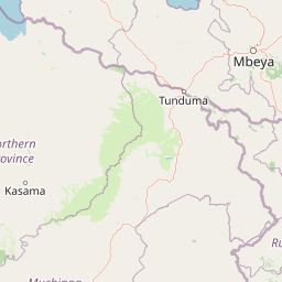
Map view of Nyika National Park

Use this park location map to pinpoint Nyika National Park in Zambia, understand its exact geographic position, and read its mapped placement within the surrounding landscape more clearly.

Pigeon | © OpenStreetMap contributors
Park atlas

Trace protected landscapes, regional park geography, and cross-border conservation areas adjacent to the Nyika Plateau.

Discover Related National Parks and Protected Areas Near Nyika National Park

Browse national parks and protected areas geographically connected to Nyika National Park, including the broader Nyika Plateau ecosystem. Compare varied landscapes, montane grasslands, and adjacent conservation efforts within Zambia and its transboundary region.
National parkMalawi
Mapped location lies within the park boundary#1 closest

East

Nyika National Park: Malawi National Park Atlas Exploration and Protected Landscape

Discover geographic context and mapped boundaries of this protected area.

Nyika National Park serves as a core entry for understanding Malawi's protected areas and natural landscapes through an atlas lens. Explore the park's designation as a national park, its geographic positioning within Malawi, and the mapped context that defines its protected status. This detail page provides a foundational view for appreciating the park's landscape and its contribution to the regional protected lands overview.

Area
3,134 km²
Established
1966
IUCN
II
Relief
Highland
Wildlife reserveMalawi
About 44 km away#2 closest

South

Vwaza Marsh Wildlife Reserve: Geographic Atlas and Protected Landscape Overview

A lowland wilderness reserve in northern Malawi

Spanning roughly 1,000 square kilometers, Vwaza Marsh Wildlife Reserve provides a unique contrast to the surrounding highlands through its flat topography, seasonal wetlands, and dense mopane forests. This destination serves as a vital corridor for large mammals moving across the border, offering a window into the complex interplay of water-focused ecology and savanna-woodland habitats in Southeastern Africa.

Area
1,000 km²
IUCN
IV
Wildlife reserveNorthern Region
About 129 km away#3 closest

South

Chikangawa Forest Reserve: Mapping Malawi's Viphya Mountains Protected Wildlife Landscape

Explore montane forest ecosystems and exotic pine plantations

Chikangawa Forest Reserve stands as a major protected block within Malawi's Northern Region. The area covers extensive mountain ridges where native montane vegetation interweaves with significant man-made pine plantations. This geographic atlas entry provides insight into the reserve's role as a watershed protector and its unique position across the Viphya Plateau.

Area
1,147.8 km²
Established
1948
Relief
Mountain
Climate
Tropical
Wildlife reserveMalawi
About 153 km away#4 closest

South

Nkhotakota Wildlife Reserve: Protected Geography and Rift Valley Landscapes

A vast, recovering miombo woodland sanctuary in central Malawi.

Nkhotakota Wildlife Reserve represents a massive conservation effort within the Great Rift Valley, protecting 1,800 square kilometres of steep ridges, riverine gorges, and dense woodland patches. This atlas entry details the reserve's unique topography, ranging from high-altitude escarpments down toward Lake Malawi, and its role as a pivotal site for large mammal restoration and bird diversity in Southeastern Africa.

Area
1,800 km²
IUCN
IV
Relief
Mixed relief
Climate
Tropical
National parkMuchinga Province
About 158 km away#5 closest

Southwest

North Luangwa National Park: National Park Protected Landscape and Regional Geography

Mapped boundaries and geographic context within Muchinga Province.

North Luangwa National Park is a designated national park offering critical insights into Zambia's protected landscapes. This page provides an atlas-driven view of its geographic scope, emphasizing its mapped boundaries and its position within Muchinga Province. Explore the fundamental geography and protected area context that defines North Luangwa National Park for structured landscape discovery.

Area
4,636 km²
Established
1972
IUCN
II
Relief
Mixed relief
National parkNjombe Region
About 178 km away#6 closest

North

Kitulo National Park: National Park within Njombe Region's Geographic Atlas

Mapped protected area boundaries and regional landscape context.

Kitulo National Park represents a distinct national park within the geographic atlas of Tanzania's Njombe Region. This page offers a focused exploration of its protected landscape identity, highlighting its mapped boundaries and contributing to a broader understanding of regional geography. It is designed for users seeking detailed, atlas-centric information about Kitulo National Park's specific natural landscape and its position within the surrounding terrain.

Area
413 km²
Established
2005
IUCN
II
Visitors
409 annual
National parkTanzania
About 222 km away#7 closest

Northeast

Ruaha National Park: Tanzania National Park, Protected Landscape and Geographic Atlas

Mapped boundaries and regional landscape context for Ruaha National Park.

Explore the protected landscape of Ruaha National Park in Tanzania. This page provides detailed mapping of its boundaries and offers insights into its geographic setting. Understand its significance as a national park within the atlas of protected areas, focusing on its natural terrain and regional context without travel logistics.

Area
20,226 km²
Established
1964
IUCN
II
Visitors
21.3K annual
National parkZambia
About 224 km away#8 closest

Southwest

Lukusuzi National Park: Zambia's Protected National Park Geographic Context

Mapped protected area and regional landscape identity for Lukusuzi.

Gain detailed insights into Lukusuzi National Park, a key protected area in Zambia, through its geographic setting and mapped boundaries. This page provides essential context for understanding the park's landscape character and its significance within the national park atlas. Explore the fundamental protected-area geography of this distinct Zambian natural landscape.

IUCN
II
Access
Access unknown
Scope
Terrestrial

Common questions about visiting, size, designation, and location context for Nyika National Park

Nyika National Park FAQs for park facts, access, geography, and protected area context

Find quick answers about Nyika National Park, including protected-area facts, park geography, trail and visitor context, and how the park fits into its surrounding country and regional landscape.
MoriAtlas Explorer

Continue Your Protected Areas Search Across the Global Atlas

Deepen your exploration by continuing the structured search for national parks and protected areas worldwide. Utilize the comprehensive filtering capabilities to compare different conservation landscapes and refine your understanding of global park geography. Discover more about the distribution and characteristics of protected natural areas.

Global natural geography