
Mori Atlas logo
Protected landscapeObere Lußhardt

A detailed atlas overview of forest biotopes, lowland stream corridors, and meadow geography

Obere Lußhardt Protected Landscape: Geographic Mapping and Regional Terrain Analysis

(Landschaftsschutzgebiet „Obere Lußhardt“)

Obere Lußhardt forms an extensive protected landscape on the Hardt plain within the Baden-Württemberg region of Germany. This geographic entry focuses on the characteristic woodland cover and narrow meadow corridors that follow the Wagbach and Duttlacher Graben. Explore the structural interplay between historical forest biotopes and managed grassland that define the physical identity of this significant regional terrain.

protected landscapelowland forestHardt plainwoodland conservationgrassland corridorssmall stream valleys
A digital illustration of a scenic mountain valley with a winding river, tall cliffs on the left, a waterfall on the right, and evergreen trees in the foreground, with hikers walking on a trail.

Obere Lußhardt

Protected landscape

Park overview

Structured park overview, official facts, and landscape profile for Obere Lußhardt Landscape Protection Area

Obere Lußhardt Landscape Protection Area park facts, protected area profile, and essential visitor context

Review the core facts for Obere Lußhardt Landscape Protection Area, including designation, size, terrain, visitor scale, habitats, and operating context in one park-focused overview.

About Obere Lußhardt Landscape Protection Area

Obere Lußhardt is a protected landscape area in the upper Rhine lowland, in Baden-Württemberg, between the cities of Bruchsal and Waghäusel and the smaller communities of Hambrücken and Ubstadt-Weiher. It sits on the Hardt plain, a low and historically sandy plateau that has long been associated with woodland. The protected area reflects this regional character: most of its roughly 5.9 square kilometers are forest, and only the valleys of the Wagbach and the Duttlacher Graben provide open ground.

The protected landscape is organized into two separate sub-areas. The larger of the two lies north of Hambrücken along the Wagbach and the Duttlacher Graben, while the second sub-area lies east of Hambrücken, also along the Duttlacher Graben. A central element of the area is the Gemswiesen, a corridor of grassland that links the Wagbach meadows to those along the Duttlacher Graben, providing an ecological connection through what would otherwise be unbroken forest.

The forest communities are partially mapped as forest biotopes and are considered important for several relatively rare plant and animal species. While the woodland gives Obere Lußhardt its broad character, the open meadows and small streams along the Wagbach and Duttlacher Graben add structural diversity and ecological contrast. The protected area borders other protected landscapes in the district, including Hambrücker Wiesen and Saalbachniederung, and partly overlaps with the FFH site Lußhardt zwischen Reilingen und Karlsdorf, integrating it into a wider network of habitat and landscape protection in the northern Karlsruhe region.

Quick facts and research context for Obere Lußhardt Landscape Protection Area

Obere Lußhardt is a landscape protection area, classified under the international system as a Protected Landscape / Seascape (IUCN Category V). It lies in Baden-Württemberg, in the Landkreis Karlsruhe, and spans parts of the cities of Bruchsal and Waghäusel together with the municipalities of Hambrücken and Ubstadt-Weiher. The protected area covers about 5.9 square kilometers, although protection is organized across two separate sub-areas rather than a single continuous block.

Natural region: the protected area belongs to the Hardtebenen, the flat Hardt plateau of the upper Rhine lowlands. The site is administered by the Landratsamt Karlsruhe and was designated on 13 August 1973. It adjoins other protected landscapes such as Hambrücker Wiesen and Saalbachniederung and overlaps with the FFH site Lußhardt zwischen Reilingen und Karlsdorf.

Protection and recognition

Explore documented conservation scope and regulatory status records for Obere Lußhardt

Obere Lußhardt Protection Status and Terrestrial Conservation Data

Comprehensive conservation data details the documented terrestrial protection status and management framework established for Obere Lußhardt. Structured records organize baseline designation metrics, regulatory parameters, and international database identifiers.

Protection details

Protection scope
Terrestrial
Transboundary protection
No
WDPA ID
323343
Park context

Deeper park guide and search-rich context for Obere Lußhardt Landscape Protection Area

Obere Lußhardt Landscape Protection Area history, landscape, wildlife, and travel context

Explore Obere Lußhardt Landscape Protection Area through its history, landscape character, ecosystems, wildlife, conservation priorities, cultural context, and seasonal travel timing in a structured park guide built for atlas discovery and search intent.

Why Obere Lußhardt Landscape Protection Area stands out

Obere Lußhardt is best known for its large, contiguous forest area on the Hardt plain and for the unusual way in which narrow strips of managed grassland and small stream corridors cut through that woodland. The protected area derives much of its identity from forest biotopes that contain rare plants and animals, with the Scheiden-Gelbstern (a yellow-striped Gagea species) cited as a notable botanical feature. The site is also known as a quiet, ecologically framed complement to the surrounding lowland landscapes of the northern Karlsruhe district. Because most of the area is forested, it functions primarily as a woodland conservation area, while the Wagbach and Duttlacher Graben meadows give it parallel grassland and small-stream habitat value. The result is a protected landscape where forest cover, meadow corridors, and small watercourses combine in a compact, regionally typical pattern.
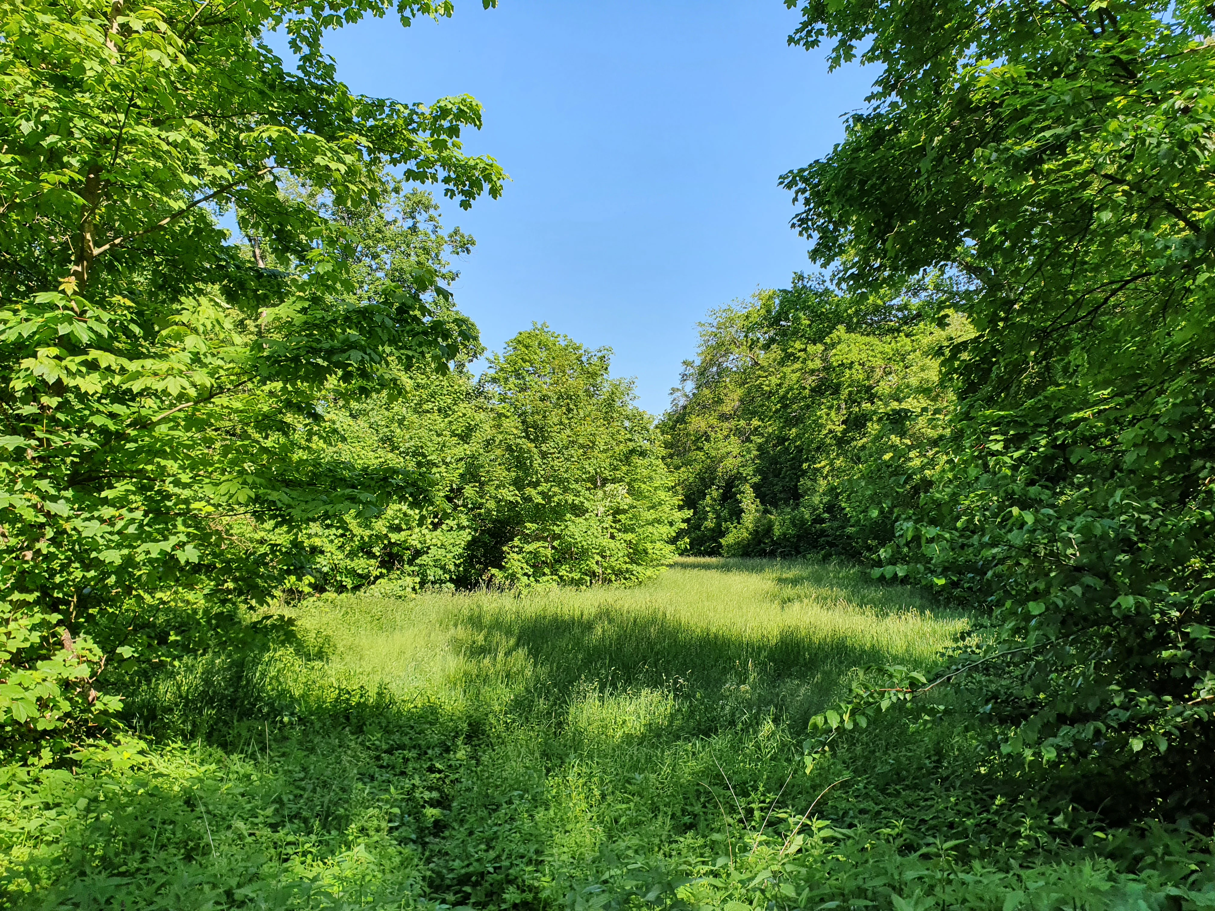
A sunlit, grassy meadow bordered by lush, dense deciduous trees under a clear blue sky.
A green meadow nestled between dense trees at the edge of the Obere Lußhardt protected area.

Obere Lußhardt Landscape Protection Area history and protected-area timeline

Obere Lußhardt was designated as a protected landscape by the Landratsamt Karlsruhe on 13 August 1973, through a formal ordinance that placed the area under the protection category of Landschaftsschutzgebiet. The protected landscape was set up to safeguard the forested character of the Hardt plain north of Hambrücken and the surrounding meadow corridors of the Wagbach and the Duttlacher Graben from further fragmentation or degradation.

Since its establishment, the area has been integrated into the broader system of protected landscapes in Landkreis Karlsruhe and has been formally recognized in the regional register of protected areas in Baden-Württemberg. At a later stage, parts of the area were also incorporated into the European Natura 2000 network through the designation of the FFH site Lußhardt zwischen Reilingen und Karlsdorf, which brings the broader Lußhardt forest block under EU-level habitat protection alongside the existing national landscape protection.

Obere Lußhardt Landscape Protection Area landscape and geographic character

The landscape of Obere Lußhardt is shaped by the flat to gently undulating terrain of the Hardt plain, a low sandstone and sandy plateau of the upper Rhine lowlands. Most of the protected area is covered by forest, giving it a closed, wooded appearance for much of its extent. The name "Lußhardt" itself reflects this regional woodland identity, referring to the historical forest cover of the area north of Karlsruhe.

The woodland is interrupted only by narrow, elongate open landscapes along the Wagbach and the Duttlacher Graben. These streams and their accompanying meadows form ribbon-like corridors through the forest, with the Gemswiesen acting as a connecting link between the two stream systems. Because the open areas are mostly used as managed grassland, the visual transition between forest and meadow is sharp and clearly defined. The overall impression is that of a lowland forest landscape with linear meadow and stream inclusions, typical of the transition zone between the Rhine plain and the Kraichgau.

Obere Lußhardt Landscape Protection Area ecosystems, habitats, and plant life

Ecologically, Obere Lußhardt is dominated by forest habitats, which are partly classified as officially recognized forest biotopes in Baden-Württemberg. The woodland on the sandy soils of the Hardt plain supports a mix of species typical of Rhine lowland forests, with stands that are valued both for their continuity and for their habitat quality. This forest continuity is a defining characteristic of the site.

Running through the forest are grassland corridors along the Wagbach and the Duttlacher Graben, with the Gemswiesen forming a connecting meadow strip. These open habitats contribute small-stream and grassland elements to an otherwise heavily forested protected area. The combination of large continuous woodland blocks with narrow, ecologically active meadow and stream corridors gives the area a habitat mosaic that, although not large, is structurally diverse. The protection of forest biotopes within the area, and the ecological role of the meadow corridors, form the basis of the area's nature conservation significance.

Obere Lußhardt Landscape Protection Area wildlife and species highlights

Information on wildlife in Obere Lußhardt is limited in publicly available sources, but the area is recognized for supporting species associated with lowland Rhine forests and forest biotopes, including some rarer animal species that depend on the continuity of woodland cover. The combination of forest blocks and small open watercourses creates habitat conditions for typical woodland fauna as well as for species associated with stream corridors and meadows.

Because detailed, source-supported species inventories for this protected landscape are not available, more specific claims about individual mammal, bird, reptile, or invertebrate species are not made here. The protected area is, however, understood to function as habitat for the fauna typical of the Hardt plain and the broader northern Karlsruhe district.

Obere Lußhardt Landscape Protection Area conservation status and protection priorities

Conservation in Obere Lußhardt centers on preserving an unusually large, contiguous block of lowland forest on the Hardt plain. By designating the area as a Landschaftsschutzgebiet in 1973, the Landkreis Karlsruhe placed most of the local forest under formal protection from changes in land use, fragmentation, or development. Forest biotopes within the protected area are specifically recognized in the regional register, underlining that the woodland itself is the principal object of conservation.

Part of the area further overlaps with the FFH site Lußhardt zwischen Reilingen und Karlsdorf, bringing Obere Lußhardt into the European Natura 2000 network and giving parts of it a higher-level habitat protection framework. This dual status, regional landscape protection and European habitat protection, means that the conservation goals of the area are pursued on two complementary levels: maintaining the broader landscape character at the regional level, and preserving specific habitat qualities at the European level.

Obere Lußhardt Landscape Protection Area cultural meaning and human context

The cultural context of Obere Lußhardt is closely tied to the traditional land use of the northern Hardt plain between Bruchsal, Waghäusel, Hambrücken, and Ubstadt-Weiher. The forest has long been the dominant cultural feature of this part of the region, while the narrow stretches of grassland along the Wagbach and the Duttlacher Graben reflect the historical use of the small streams and their floodplains for hay production and pasture.

The Gemswiesen, the meadow corridor connecting the two stream systems, is part of this small-scale agricultural heritage. Although the protected area is not primarily defined by cultural or historical landmarks, its landscape reflects centuries of interaction between woodland use and stream-valley farming in the northern Karlsruhe district.

Top sights and standout views in Obere Lußhardt Landscape Protection Area

Highlights of Obere Lußhardt include the large block of protected lowland forest on the Hardt plain, the registered forest biotopes within it, and the narrow but ecologically important meadow and stream corridors along the Wagbach and the Duttlacher Graben. The Gemswiesen corridor is a particularly distinctive feature, because it joins two separate stream systems through open grassland inside an otherwise closed forest. The site is also notable for being administratively one protected landscape yet partly embedded in the wider European Natura 2000 network through the overlapping FFH site.

Best time to visit Obere Lußhardt Landscape Protection Area

Lowland forest landscapes of the upper Rhine plain can be visited at any time of year. Spring is particularly suitable for observing woodland flowers in the shaded stands of the Hardt plateau, while late spring and early summer bring the most active grassland communities along the Wagbach and the Duttlacher Graben. Late summer and early autumn are generally favorable for walking the forest tracks under relatively dry conditions, while winter offers a quieter, more open view into the deciduous stands after leaf fall.

Because most of the protected area is woodland rather than open or alpine terrain, seasonal access is not subject to the kind of restrictions that apply to high mountain reserves, and visits can be planned around weather and local conditions rather than around dramatic seasonal closures.


Monthly climate preview

Long-term representative coordinates showing annual temperature ranges and precipitation rhythm

Obere Lußhardt Climate Normals and Representative Monthly Temperature Patterns

Obere Lußhardt exhibits a measured annual cycle of temperature and precipitation based on long-term representative coordinate data spanning 1991 to 2020. Examining the complete twelve-month climate profile reveals detailed monthly averages across temperature extremes and precipitation rates.
Annual mean9 °C
0 °C20 °C
Jan
Feb
Mar
Apr
May13°
Jun17°
Jul20°
Aug19°
Sep15°
Oct10°
Nov
Dec
Warmest month
July

19.6 °C

Coolest month
January

-0 °C

Wettest month
May

2.7 mm/day

Driest month
April

1.7 mm/day

Park location guide

Geography guide, regional context, and park location map for Obere Lußhardt Landscape Protection Area

Obere Lußhardt Landscape Protection Area park geography, regions, and map view in Germany

Understand where Obere Lußhardt Landscape Protection Area sits in Germany through a broader geographic reading of the surrounding landscape, nearby location context, and its mapped position within the national park landscape.

How Obere Lußhardt Landscape Protection Area fits into Germany

Germany is a federal republic in Western and Central Europe with a population of over 83 million across sixteen constituent states. It is Europe's largest economy by nominal GDP and a major global exporter and importer. The capital is Berlin, and the country borders Denmark, Poland, Czech Republic, Austria, Switzerland, France, Luxembourg, Belgium, and the Netherlands.

Wider geography shaping Obere Lußhardt Landscape Protection Area in Germany

Germany is located in Western and Central Europe, spanning 357,022 km². It borders Denmark to the north, Poland and the Czech Republic to the east, Austria and Switzerland to the south, and France, Luxembourg, Belgium, and the Netherlands to the west. The country has coastlines on the Baltic Sea and North Sea to the north, with the Alps located in the southern region.

Map view of Obere Lußhardt Landscape Protection Area

Use this park location map to pinpoint Obere Lußhardt Landscape Protection Area in Germany, understand its exact geographic position, and read its mapped placement within the surrounding landscape more clearly.

Pigeon | © OpenStreetMap contributors

Location context for Obere Lußhardt Landscape Protection Area

Baden-Württemberg

Visualizing lowland forest biotopes and narrow meadow corridors on the Hardt plain

Obere Lußhardt Photos and Protected Landscape Scenery

Visual documentation reveals the dense woodland cover and linear stream valleys that define the protected terrain of Obere Lußhardt. Examining field photographs helps researchers understand how contiguous forest blocks and narrow grassland corridors shape regional habitats.

A sunlit, grassy meadow bordered by lush, dense deciduous trees under a clear blue sky.

Park atlas

Discover related lowland forests and regional nature reserves across the Hardt plain.

Explore Other Parks Near Obere Lußhardt and Surrounding Protected Landscapes

Compare Obere Lußhardt with adjacent protected areas across the northern Karlsruhe district and surrounding lowland terrain. Examining these related woodland reserves reveals broader ecological patterns connecting regional river plains and forest biotopes.
A soft watercolor illustration of a rolling meadow landscape featuring green grasses and pink flowers against a light background.
Protected landscapeBaden-Württemberg
About 2 km away#1 closest

Southwest

Hambrücker Wiesen Protected Landscape: A Geographical Atlas of Baden-Württemberg Terrain

Mapped meadows, wetland corridors, and regional landscape boundaries

Spanning 107 hectares in the Hardtebenen, Hambrücker Wiesen functions as a critical protected landscape in Baden-Württemberg. The area anchors a diverse geographic profile featuring lowland hay meadows, reed beds along the Wagbach, and open agricultural terrain. Discover how this site integrates into the broader network of protected zones within the Upper Rhine Plain while preserving its traditional rural character against development.

Area
1.066 km²
Established
1991
IUCN
V
Relief
Lowland
Protected landscapeBaden-Württemberg
About 8.5 km away#2 closest

East

Um die Großwiese Protected Landscape: Geography of the Northern Kraichgau Cultural Mosaic

Mapped protected area in the Landkreis Karlsruhe region.

Um die Großwiese is a designated landscape protection area in Bad Schönborn, characterizing the transitional foothill zone of the Kraichgau. The terrain comprises a high-value collection of sessile oak and hornbeam forests, traditional orchards, and riparian stream corridors. This detailed atlas entry provides context on the physical boundaries and landscape elements preserved within this German regional site.

Area
2.529 km²
Established
1990
IUCN
V
Relief
Upland
A pale, minimalist watercolor painting showing a wide river flowing through a lush green floodplain with rolling hills in the background.
Nature reserveRhineland-Palatinate
About 11 km away#3 closest

Northwest

Speyerer Auwald Nature Reserve: Protected Alluvial Forest Geography in Rhineland-Palatinate

An essential Rhine valley floodplain and habitat mosaic

Located along the Upper Rhine, the Speyerer Auwald encompasses a vital protected landscape of alluvial forests, relic oxbows, and traditional meadows. This record traces the park boundaries, hydrological features, and the distinct ecological zones that make this floodplain forest a cornerstone of the regional geography in Rhineland-Palatinate.

Relief
Lowland
Climate
Temperate
Access
Easy access
Scope
Terrestrial
A horizontal watercolor painting depicting a soft-focus landscape with a central tree, calm water, and rolling hills in the background.
Nature reserveRhineland-Palatinate
About 12 km away#4 closest

West

Brückenkopf Nature Reserve: An Atlas of Protected Floodplain Geography in Rhineland-Palatinate

Detailed mapping of rare wetland habitats and regional floodplain zones

Brückenkopf offers a unique look at small-scale habitat conservation in the Germersheim district. This nature reserve protects a vital fragment of the Upper Rhine floodplain, serving as a sanctuary for specific wetland flora and rare invertebrates. Gain a better understanding of its location between major infrastructure corridors and the river, marking it as a significant component of regional conservation strategy.

Area
0.357 km²
Established
1982
IUCN
IV
Relief
Lowland
Nature reserveRheinland-Pfalz
About 12 km away#5 closest

Northwest

Flotzgrün Nature Reserve: Protected Floodplain Landscapes and Rhine Geography in Rheinland-Pfalz

Mapping historical island creation and modern conservation polders

Flotzgrün serves as a compelling geographic entity within the Upper Rhine, functioning as both an active flood management polder and a protected riparian environment. This site offers insights into the intersection of 19th-century river straightening and modern ecological restoration, revealing a landscape defined by controlled wetlands, old river arms, and managed floodplain habitats.

Area
3.4 km²
Relief
Lowland
Scope
Terrestrial
Water
Major water bodies
Watercolor painting of a tranquil wetland landscape with soft green vegetation and a calm water body, reflecting the floodplain environment of the Rhine river.
Nature reserveLandkreis Germersheim
About 12 km away#6 closest

West

Hördter Rheinaue Nature Reserve: Landscape and Geographic Context in Landkreis Germersheim

Examining the hydrology and floodplain forest of the German Rhine.

Hördter Rheinaue serves as a critical node in the Palatinate Rhine floodplains, preserving a vast mosaic of willow and poplar forests alongside stable hardwood stands. Analyze the mapped terrain shaped by centuries of river activity, including the meandering Michelsbach and associated oxbow systems that define this essential protected corridor in western Germany.

Area
8.18 km²
Established
1966
IUCN
IV
Relief
Lowland
A pale, atmospheric watercolor painting showing a quiet river scene with green trees and a hanging branch in the foreground, rendered in a light and airy style.
Nature reserveRhineland-Palatinate
About 12 km away#7 closest

Northwest

Schwarzwald Nature Reserve: A Protected Rhine Floodplain Landscape in Rhineland-Palatinate

Geographic atlas of alluvial forests and oxbow river dynamics

Schwarzwald represents a significant nature reserve in Germany, characterized by its position between the modern Rhine and the Lingenfelder Altrhein. The area contains a rich collection of floodplain features, including alluvial forests, pollarded willows, and standing gravel pit lakes, offering a comprehensive look at the riparian geography of the Upper Rhine.

Area
3.41 km²
Established
1997
Soft watercolor painting of an oxbow lake landscape with green riverbanks, trees, and distant rolling hills against a pale sky.
Nature reserveRhineland-Palatinate
About 16 km away#8 closest

Southwest

Leimersheimer Altrhein Nature Reserve: Mapped Geography and Protected Area Context

A preserved Rhine oxbow ecosystem in Rhineland-Palatinate

Leimersheimer Altrhein represents a rare, enduring fragment of the historical Rhine floodplain. This site hosts vital waterbird populations within an enclosed water landscape, providing essential habitat connectivity in a heavily regulated river region. Gain insights into the specific terrain, boundary configurations, and riparian mosaic that define this protected nature reserve.

Area
15 km²
Established
2004
IUCN
IV

Common questions about visiting, size, designation, and location context for Obere Lußhardt Landscape Protection Area

Obere Lußhardt Landscape Protection Area FAQs for park facts, access, geography, and protected area context

Find quick answers about Obere Lußhardt Landscape Protection Area, including protected-area facts, park geography, trail and visitor context, and how the park fits into its surrounding country and regional landscape.
MoriAtlas Explorer

Continue Your Protected Areas Search Across the Global Atlas

Deepen your exploration by continuing the structured search for national parks and protected areas worldwide. Utilize the comprehensive filtering capabilities to compare different conservation landscapes and refine your understanding of global park geography. Discover more about the distribution and characteristics of protected natural areas.

Global natural geography