Mori Atlas logo
Nature reserveOhlsteinbruch bei Steinau an der Straße

A detailed examination of the basalt quarry, juniper heathlands, and forest mosaics within this unique protected landscape.

Ohlsteinbruch bei Steinau an der Straße: Protected Nature Reserve and Geological Landscape in Hessen

(Naturschutzgebiet Ohlsteinbruch bei Steinau an der Straße)

The Ohlsteinbruch bei Steinau an der Straße nature reserve represents a distinctive convergence of post-industrial geological character and traditional cultural landscape management in eastern Hessen. Covering a compact area centered on an abandoned basalt quarry, the reserve hosts a diverse mosaic of mat-grass swards, dry meadows, and beech forest fragments that support rare invertebrate and floral communities. This protected area functions as a significant Natura 2000 site, offering a window into the complex ecological recovery and successional terrain of the central German uplands.

nature reservebasalt quarryjuniper heathlanddry grasslandmat-grass swardsbeech forest

Ohlsteinbruch bei Steinau an der Straße

Nature reserve

Park overview

Structured park overview, official facts, and landscape profile for Ohlsteinbruch bei Steinau an der Straße

Ohlsteinbruch bei Steinau an der Straße park facts, protected area profile, and essential visitor context

Review the core facts for Ohlsteinbruch bei Steinau an der Straße, including designation, size, terrain, visitor scale, habitats, and operating context in one park-focused overview.

About Ohlsteinbruch bei Steinau an der Straße

The Ohlsteinbruch bei Steinau an der Straße is a compact but ecologically rich nature reserve in the Main-Kinzig district of Hessen, situated in the natural region known as the Sandstein-Spessart within the broader Odenwald, Spessart and Südrhön unit. The reserve follows the geological transition between the volcanic Vogelsberg influence to the north and the sedimentary Schlüchterner Becken to the south, a setting that produces a striking mix of rock types and soils across a very small footprint.

The protected area includes the onetime "Ohl" basalt quarry, woodland cover, and a network of juniper heaths and species-rich meadows that have been shaped by centuries of grazing and traditional mowing. Although the site is small compared with many protected areas, the unusually steep ecological gradients between exposed volcanic rock, shallow stony soils, and deeper forest soils allow a high variety of habitat types to coexist. Open juniper heaths, dry mat-grass swards, and verges along woodland edges form a near-continuous chain of dry grassland habitats that are otherwise rare in this part of Hessen.

The reserve carries both national and European designations: it is classified as a Naturschutzgebiet under Hessian law, while the same boundary defines a Flora-Fauna-Habitat area that links it into the pan-European Natura 2000 network. This dual status reflects the site's broader importance for habitat conservation, particularly for dry grassland and silicate rock communities that are priorities at the EU level.

Quick facts and research context for Ohlsteinbruch bei Steinau an der Straße

The Ohlsteinbruch bei Steinau an der Straße is a designated nature reserve located in the Main-Kinzig-Kreis district of Hessen, central Germany. It covers approximately 25 hectares on the northeastern edge of Steinau an der Straße, near the A66 motorway, on a terrain that ranges roughly from 250 to 359 meters in elevation.

The site is concurrently a Flora-Fauna-Habitat area within the Natura 2000 network, integrating national protection with European habitat conservation. Its foundation rests on an abandoned basalt quarry, encircled by juniper heathland, mat-grass swards, dry meadows, and beech forest fragments. The reserve was first designated in 1984 and the FFH area was formally confirmed under Hessian Natura 2000 legislation in 2008.

Protection and recognition

Documented protection history, terrestrial scope, and international recognition records

Ohlsteinbruch bei Steinau an der Straße Protection Status and Natura 2000 Designation

Terrestrial protected area records establish the official designation history and management scope established in 2008 for Ohlsteinbruch bei Steinau an der Straße. Verified recognition data incorporates Natura 2000 documentation to outline structured conservation tracking and geographic boundaries.

International recognition

Protection details

Protection scope
Terrestrial
Designated year
2008
Transboundary protection
No
WDPA ID
164933
Park context

Deeper park guide and search-rich context for Ohlsteinbruch bei Steinau an der Straße

Ohlsteinbruch bei Steinau an der Straße history, landscape, wildlife, and travel context

Explore Ohlsteinbruch bei Steinau an der Straße through its history, landscape character, ecosystems, wildlife, conservation priorities, cultural context, and seasonal travel timing in a structured park guide built for atlas discovery and search intent.

Why Ohlsteinbruch bei Steinau an der Straße stands out

Ohlsteinbruch is best known for combining the exposed geology and rocky microhabitats of a former basalt quarry with extensive, traditionally grazed juniper heaths and mat-grass grasslands. The juxtaposition of volcanic rock, dry open habitats, and beech forest ecotones makes the reserve a textbook example of post-industrial landscape recovery in Hessen. It is also notable for the occurrence of rare warmth-loving invertebrates, including the Gesprenkelter Pappelspanner moth, which was first recorded in Hessen here in 2000, and for its orchid-rich meadows that support threatened species such as Neotinea ustulata.
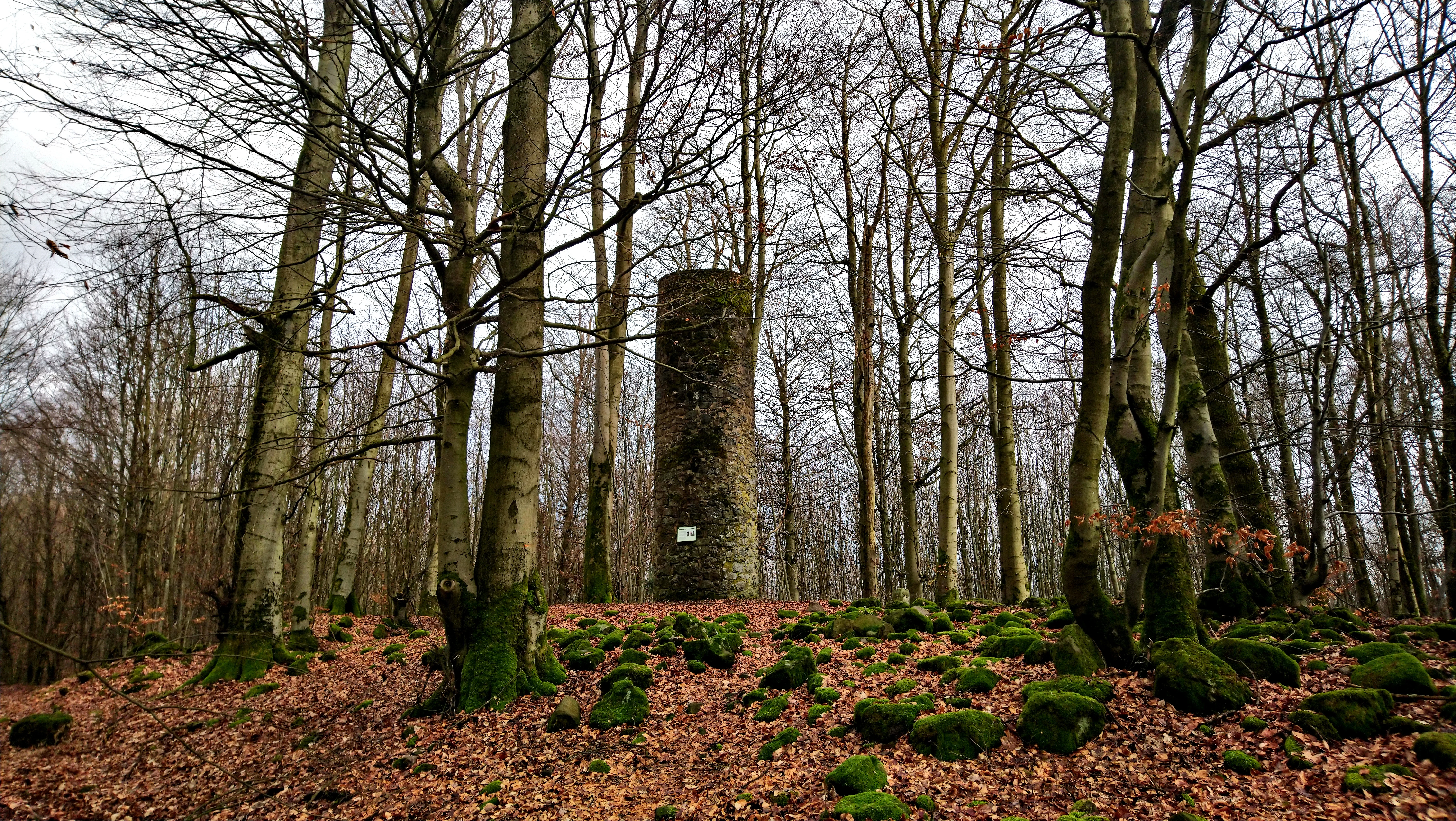
A stone observation tower rises among tall bare deciduous trees in a forest, with mossy rocks and autumn leaves covering the forest floor.
The Ohlwarte observation tower stands within the forest of the Ohlsteinbruch nature reserve.

Ohlsteinbruch bei Steinau an der Straße history and protected-area timeline

The Ohlsteinbruch area has a long history of human use that pre-dates its modern protection. Between roughly 1880 and 1930 the site was actively worked as a basalt quarry, providing stone for regional construction and infrastructure from the lava flows of the nearby Vogelsberg volcanic field. When extraction ended, the quarry and its surroundings were partially replanted with spruce and maple, while much of the disturbed ground was simply left to natural succession.

The character of the surrounding open land has its roots in traditional land use. Sheep pastures established juniper heaths where grazing kept woody plants from dominating, while wetter areas developed into Streuwiesen, traditional litter meadows mown once a year in September and used for stable bedding. These cultural practices created exactly the kind of nutrient-poor, species-rich grassland mosaic that later proved to have high conservation value.

Ohlsteinbruch bei Steinau an der Straße landscape and geographic character

The protected area occupies a varied terrain between roughly 250 and 359 meters in elevation, shaped by both volcanic and sedimentary geology. Alkali-olivine basalts and tuffs from the Vogelsberg volcanic system sit alongside solifluction debris, loam, and limestone-dolomite stones from the Schlüchterner Becken, producing an unusually mixed substrate for central Hessen.

The quarry itself forms the most visually distinctive feature of the reserve, with exposed basalt faces, rubble slopes, and shallow rock-bordered hollows. Around it, the landscape transitions through a patchwork of juniper heaths on sunny slopes, dry mat-grass swards on thin soils, and woodier pockets of beech and mixed forest. This tight geological and topographic variation drives a correspondingly fine-grained habitat mosaic that defines the visual character of Ohlsteinbruch.

Ohlsteinbruch bei Steinau an der Straße ecosystems, habitats, and plant life

Ecologically, the reserve is dominated by dry and semi-dry grassland communities set within a forest matrix. Protected habitat types recognized at the European level include mat-grass swards, juniper heaths, silicate rock communities with crevice vegetation, and Asperulo-Fagetum beech forest. Forest cover is split among beech woodland, heavily managed deciduous stands, mixed forest, and smaller conifer patches, with open habitats and ecologically valuable grassland communities collectively making up a significant share of the area.

The combination of nutrient-poor substrates, warm microclimates on south-facing slopes, and frequent transitions between open land and forest is the core of the site's ecological identity. These conditions support rare plants such as the threatened orchid Neotinea ustulata in the meadows, and they underpin an unusually rich invertebrate fauna for such a small reserve.

Ohlsteinbruch bei Steinau an der Straße wildlife and species highlights

The mosaic of dry grassland, bare rock, juniper scrub, and forest edge provides habitat for a wide range of animal groups. Grasshoppers, butterflies, and other phytophagous insects reach higher densities than usual because of the low nutrient status of the soils, which in turn supports warmth-loving moth species such as the Gesprenkelter Pappelspanner (Stegania cararia), a species that was first confirmed in Hessen at this site in 2000.

Birds are well represented through the many ecotones between open land and woodland: notable breeding records from the reserve include the red-backed shrike (Lanius collurio) and the red kite (Milvus milvus). Amphibians and reptiles historically used the quarry pools and damp hollows, including the yellow-bellied toad (Bombina variegata), although recent surveys have not been able to confirm that species' continued presence.

Ohlsteinbruch bei Steinau an der Straße conservation status and protection priorities

Ohlsteinbruch's conservation significance lies in its packed concentration of rare habitat types within a small area. The site is nationally protected as a Naturschutzgebiet and, with an identical boundary, designated as a Flora-Fauna-Habitat area within the European Natura 2000 network, placing it within a continent-wide framework for habitat and species preservation.

Active management is central to maintaining this value. Shepherd grazing and targeted mowing keep juniper heaths and meadows open by preventing woody overgrowth, while invasive or site-incompatible trees such as spruce and black locust have been actively removed. These interventions are aimed at preserving the dry grassland communities, the orchid populations, and the invertebrate fauna that depend on warm, open conditions.

Ohlsteinbruch bei Steinau an der Straße cultural meaning and human context

The reserve's identity is closely tied to traditional regional land use rather than to a single cultural landmark. Juniper heaths, litter meadows, and sheep grazing reflect agricultural practices that shaped large parts of the Main-Kinzig-Kreis for centuries and that are now maintained specifically for biodiversity reasons rather than for direct economic need.

The basalt quarry adds an industrial heritage layer to this cultural landscape. Active extraction between 1880 and 1930 marks the site as a relic of the regional stone industry, and its abandonment has become, intentionally, part of the conservation story rather than something to be erased or redeveloped.

Top sights and standout views in Ohlsteinbruch bei Steinau an der Straße

The Ohlsteinbruch nature reserve stands out for packing an unusual number of habitat types into roughly 25 hectares, all clustered around a single abandoned basalt quarry. Juniper heaths, mat-grass swards, dry meadows, silicate rock communities, and beech forest fragments sit within a few minutes' walk of one another, producing high ecological diversity in a very compact space.

The reserve is also distinctive for its dual status as a Hessian Naturschutzgebiet and a Natura 2000 Flora-Fauna-Habitat area, and for the discovery there of moth and orchid species that are rare or threatened elsewhere in Hessen.

Best time to visit Ohlsteinbruch bei Steinau an der Straße

Late spring and early summer are typically the most rewarding periods for visiting the Ohlsteinbruch, when juniper heaths, mat-grass swards, and dry meadows bring their characteristic flora into bloom and insects are most active across the warm, open slopes. These conditions are also when rare orchids such as Neotinea ustulata are most likely to be observed in the meadows.

Autumn offers a quieter, structurally interesting visit, with lower vegetation making the quarry topography and grassland mosaic easier to read, while traditional litter meadows are mown at that time of year as part of active management. Winter visits can still be rewarding for those interested in geology and woodland structure, as the bare deciduous trees reveal the underlying basalt terrain and forest patterning.

Monthly climate preview

Long-term temperature ranges and monthly precipitation averages for Hessen

Ohlsteinbruch bei Steinau an der Straße Climate Normals and Annual Weather Patterns

Historical climate data for Ohlsteinbruch bei Steinau an der Straße tracks measured monthly temperature variation from sub-zero winter lows to warm summer highs alongside steady daily precipitation rates. Examining the full twelve-month profile reveals detailed baseline normals across all recorded coordinate intervals.
Annual mean8 °C
-1 °C18 °C
Jan-1°
Feb
Mar
Apr
May12°
Jun16°
Jul18°
Aug18°
Sep14°
Oct
Nov
Dec
Warmest month
July

18.1 °C

Coolest month
January

-1.2 °C

Wettest month
July

2.6 mm/day

Driest month
April

1.6 mm/day

Park location guide

Geography guide, regional context, and park location map for Ohlsteinbruch bei Steinau an der Straße

Ohlsteinbruch bei Steinau an der Straße park geography, regions, and map view in Germany

Understand where Ohlsteinbruch bei Steinau an der Straße sits in Germany through a broader geographic reading of the surrounding landscape, nearby location context, and its mapped position within the national park landscape.

How Ohlsteinbruch bei Steinau an der Straße fits into Germany

Germany is a federal republic in Western and Central Europe with a population of over 83 million across sixteen constituent states. It is Europe's largest economy by nominal GDP and a major global exporter and importer. The capital is Berlin, and the country borders Denmark, Poland, Czech Republic, Austria, Switzerland, France, Luxembourg, Belgium, and the Netherlands.

Wider geography shaping Ohlsteinbruch bei Steinau an der Straße in Germany

Germany is located in Western and Central Europe, spanning 357,022 km². It borders Denmark to the north, Poland and the Czech Republic to the east, Austria and Switzerland to the south, and France, Luxembourg, Belgium, and the Netherlands to the west. The country has coastlines on the Baltic Sea and North Sea to the north, with the Alps located in the southern region.

Map view of Ohlsteinbruch bei Steinau an der Straße

Use this park location map to pinpoint Ohlsteinbruch bei Steinau an der Straße in Germany, understand its exact geographic position, and read its mapped placement within the surrounding landscape more clearly.

Pigeon | © OpenStreetMap contributors

Location context for Ohlsteinbruch bei Steinau an der Straße

Hessen
Recorded earthquake history

Review the Historical Earthquake Catalogue for Ohlsteinbruch bei Steinau an der Straße

Access a dedicated collection of recorded seismic activity documented within the proximity of Ohlsteinbruch bei Steinau an der Straße. MoriAtlas maintains this historical catalogue to provide geographic insight into recorded tremors near this protected Hessen nature reserve.

Ohlsteinbruch bei Steinau an der Straße Earthquake History

Catalogued events

7 events

Strongest magnitude

Magnitude 5.3

Most recent event

Jul 2, 2001

This history includes earthquakes recorded inside the park or within 50 km of its borders

Visualizing the geological terrain, juniper heaths, and basalt quarry habitats

Ohlsteinbruch bei Steinau an der Straße Photos and Landscape Scenery

Photographic records reveal the distinct topography and plant communities of Ohlsteinbruch bei Steinau an der Straße. Examining these protected area views provides clearer insight into the post industrial landscape recovery and diverse habitats of the region.

A stone observation tower rises among tall bare deciduous trees in a forest, with mossy rocks and autumn leaves covering the forest floor.

Park atlas

Compare nearby reserves, regional park geography, and connected natural landscapes

Parks Near Ohlsteinbruch bei Steinau an der Straße And Surrounding Protected Areas

Browse other parks near Ohlsteinbruch bei Steinau an der Straße to evaluate similar protected landscapes, volcanic geology, and regional habitats across the surrounding region. Extending the comparison helps map out broader conservation areas and connected natural terrain throughout central Hessen.
A soft, horizontal watercolor painting showing rolling green hills, distant mountain outlines, and clusters of evergreen trees against a pale sky.
Nature reserveHessen
1.9 km away#1 closest

South

Bellinger Berg Nature Reserve: Geography and Protected Land Boundaries in Hessen

Muschelkalk limestone cone and dry grassland mosaic

Bellinger Berg serves as a critical example of protected limestone landforms in Hessen. The nature reserve encompasses a 345-meter conical hill where specialized calcareous grassland and scrubland thrive on thin, base-rich soils. By maintaining this habitat mosaic, the site provides a vital ecological bridge within the broader eastern Spessart region, preserving the site's distinct silhouette and historical landscape character.

Area
0.955 km²
Established
1985
IUCN
IV
Relief
Mountain
Nature reserveLandkreis Main-Spessart
14 km away#2 closest

Southeast

Sinngrund Nature Reserve: Geographic Map and Protected Landscape Overview

Riverine corridor and wet meadow habitats in Landkreis Main-Spessart

Sinngrund preserves a unique floodplain landscape along the Sinn river in Bavaria. The area features a complex mosaic of wet meadows, oxbow channels, and forest fragments that support significant botanical populations and regional wildlife. This record details the protected boundaries and landscape context of the reserve within the broader Naturpark Spessart.

Area
3.79 km²
Established
1999
Relief
Upland
Climate
Temperate
A watercolor painting of a green, rolling meadow landscape with distant hills under a soft, light sky.
Nature reserveWetteraukreis
About 33 km away#3 closest

West

Nidderauen von Stockheim Nature Reserve: A Detailed Geographic and Protected Landscape Map

Wetland floodplain geography in the Wetteraukreis region

This protected nature reserve spans 51 hectares of the Nidder river valley, forming a critical segment of the Auenverbund Wetterau. The landscape is defined by its mosaic of wet meadows, ponds, and tall herb vegetation, maintained by targeted conservation management and river restoration. Access the map-driven context of this European FFH site to understand its role in regional wetland preservation and habitat connectivity.

Area
0.512 km²
Established
1981
Relief
Lowland
Climate
Temperate
Nature reserveHessen
35 km away#4 closest

Southwest

Kinzigaue von Langenselbold: Nature Reserve and Protected Floodplain in Hessen

Riparian ecosystems, alluvial forests, and wetland geography

Spanning 129 hectares, Kinzigaue von Langenselbold represents a well-preserved riverine corridor in central Germany. The reserve integrates the meandering Kinzig river, mature gallery forests, and the Ruhlsee into a compact, protected landscape that serves as an essential habitat for diverse bird species and rare floodplain vegetation.

Area
1.287 km²
Established
1980
IUCN
IV
Protected areaGermany
About 35 km away#5 closest

West

Bruch von Heegheim Protected Area: A Wetland Landscape in the Nidder River Valley

Mapped wetland habitats and ecological site geography

Bruch von Heegheim is a specialized nature reserve that protects a delicate mosaic of shallow water bodies and reed-dominated marshes in the German district of Wetteraukreis. The site serves as a vital refuge for European tree frogs and breeding marshland birds, demonstrating how compact protected lands contribute to broader biodiversity conservation within agricultural floodplains.

Area
0.108 km²
Established
1976
Relief
Lowland
Climate
Temperate
Nature reserveHesse
About 35 km away#6 closest

West

Im Rußland und in der Kuhweide bei Lindheim: Nature Reserve and Floodplain Geography

Protected grassland landscapes in the Wetterau, Hesse.

Located in the Wetteraukreis district of Hesse, this nature reserve protects extensive floodplain meadows along the Nidder river. The area is defined by its open grassland mosaic, providing critical refuge for meadowbirds and diverse amphibian populations. Access detailed map data and landscape context for this significant German conservation site.

Area
2.495 km²
Established
1984
Relief
Lowland
Climate
Temperate
Protected landscapeHesse
About 36 km away#7 closest

Northeast

Naturpark Hessische Rhön: Geographic Profile and Protected Landscape Mapping

Mapping the Rhön low mountains and upland ecosystems in Hesse

Naturpark Hessische Rhön encompasses approximately 720 square kilometers of varied terrain north and west of Fulda. The area features a distinct mosaic of forests, streams, and protected biotope complexes. This overview provides insight into the regional geography and the conservation structure defining this prominent upland protected landscape.

Area
720 km²
Established
1962
Relief
Upland
Scope
Terrestrial
A horizontal watercolor illustration showing a meandering stream flowing through open green grasslands with scattered trees and low hills in the background.
Nature reserveHessen
About 38 km away#8 closest

West

Nachtweid von Dauernheim Nature Reserve: Geographic Overview and Wetland Conservation

Saline meadows and floodplain habitats in Hessen

Nachtweid von Dauernheim is a specialized nature reserve in the Wetterau district, defined by its rare saline-influenced grassland flora and extensive sedge marshes. As a core rail bird biotope, the site anchors a wider wetland network alongside the Nidda river floodplain. This protected area offers a deep look into central Germany's unique hydrologic conditions and sensitive open-terrain conservation.

Area
0.789 km²
Established
1978

Common questions about visiting, size, designation, and location context for Ohlsteinbruch bei Steinau an der Straße

Ohlsteinbruch bei Steinau an der Straße FAQs for park facts, access, geography, and protected area context

Find quick answers about Ohlsteinbruch bei Steinau an der Straße, including protected-area facts, park geography, trail and visitor context, and how the park fits into its surrounding country and regional landscape.
MoriAtlas Explorer

Continue Your Protected Areas Search Across the Global Atlas

Deepen your exploration by continuing the structured search for national parks and protected areas worldwide. Utilize the comprehensive filtering capabilities to compare different conservation landscapes and refine your understanding of global park geography. Discover more about the distribution and characteristics of protected natural areas.

Global natural geography