Why Payette National Forest stands out
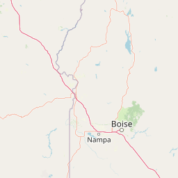
Payette National Forest is best known as the largest contributor to the Frank Church-River of No Return Wilderness, the second-largest designated wilderness area in the contiguous United States. It is also recognized for the dramatic Seven Devils Mountains, glacial lakes and granite outcrops, and its setting above the Idaho Batholith. The forest anchors a vast roadless landscape of rugged ridges, deep canyons, and salmon-bearing rivers, and serves as a key stronghold for elk, bighorn sheep, and threatened salmon and steelhead populations. Its combination of large-scale wilderness, varied elevation zones, and ecological connectivity with neighboring forests defines its distinctive identity within the National Forest System.
Payette National Forest history and protected-area timeline
The history of Payette National Forest begins not with a single founding event but with the broader movement to protect American forests in the late 19th century. The Forest Reserve Act of 1891 gave the federal government authority to set aside forest lands from the public domain, and in the years that followed, two reserves were established in the region that would eventually become Payette: the Weiser Reserve in 1905 and the Idaho Reserve in 1908. These early reserves laid the groundwork for what would become a single, unified national forest.
On April 1, 1944, the Weiser and Idaho forest reserves were merged to create the official Payette National Forest, consolidating roughly 2.3 million acres of land into one administrative unit. The name honors François Payette, a French-Canadian fur trapper who became manager of Fort Boise for the Hudson's Bay Company from 1835 to 1844. Arriving in the region in 1818 after traveling east from Astoria, Oregon, Payette was one of the first white settlers in the area and was widely remembered for his genial character and willingness to help travelers passing through. He returned to Montreal in 1844, and the details of the remainder of his life remain unknown.
In the decades since its formation, Payette National Forest's significance has only grown. The inclusion of large portions of the forest within the Frank Church-River of No Return Wilderness in 1980, followed by official wilderness designation for much of the Hells Canyon corridor, transformed the forest into one of the central components in America's largest contiguous wilderness landscape outside Alaska. Today, the forest's history is intertwined with the broader story of public-land conservation in Idaho and the Northern Rockies.
Payette National Forest landscape and geographic character
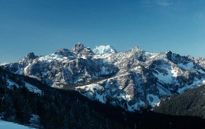
The landscape of Payette National Forest is dominated by rugged mountains, deep river canyons, and high plateaus shaped by the underlying Idaho Batholith, the largest granitic rock body in the United States. This massive geological substrate produces the resistant bedrock that gives the forest its dramatic vertical relief and contributes to the steep, jagged character of many of its peaks. Along the western edge of the forest, the Seven Devils Mountains rise prominently, offering some of the most striking alpine scenery in Idaho.
Glacial processes further defined the terrain. As recently as 15,000 years ago, glaciers scoured the upper basins of the forest, leaving behind U-shaped valleys, glacial lakes, cirques, and polished granite outcrops. These features are scattered across the high country and create the characteristic pattern of clear mountain lakes interspersed with rocky domes and forested slopes. Toward the west, the forest drops sharply toward Hells Canyon, one of the deepest gorges in North America, where the Snake River has carved through basalt and older bedrock at the forest's boundary.
Between these alpine peaks and the canyon's edge lies an interconnected system of ridges, meadows, and forested valleys drained by tributaries of the Salmon and Snake rivers. This varied topography produces abrupt transitions in vegetation and scenery, from dry, open lower slopes to dense coniferous forests and rocky high country, giving the forest its reputation as one of the most topographically diverse national forests in the Northern Rockies.
Payette National Forest ecosystems, habitats, and plant life
Ecologically, Payette National Forest spans a steep elevation gradient that produces a layered mosaic of vegetation types. Eight species of conifers grow across these zones, including Douglas-fir, lodgepole pine, ponderosa pine, subalpine fir, Engelmann spruce, whitebark pine, grand fir, and western red cedar, each tied to specific moisture, soil, and elevation conditions. This coniferous complexity supports distinct understory plant communities and gives the forest a structurally diverse profile, especially in the transition zones between dry lower slopes and moist higher elevations.
Glacial and geological history continues to shape the forest's ecological character. Pleistocene glaciers carved the high basins and left behind lakes, moraines, and polished granite outcrops that create microhabitats for moisture-loving plants and wildflowers. In summer, montane and subalpine meadows erupt with diverse wildflower displays, attracting pollinators and serving as seasonal forage for bears, elk, and bighorn sheep. Streams and lakes drain either toward the Salmon River or the Snake River, two of Idaho's most ecologically important waterways, providing continuous freshwater linkages between high country and major river valleys.
Payette National Forest wildlife and species highlights
The forest supports a diverse community of mammals and birds across its elevation gradient, including elk, mule deer, bighorn sheep, black bears, mountain lions, moose, martens, and northern flying squirrels. Predators such as wolves and grizzly bears also use portions of the forest, particularly within the wilderness complex, and the extensive habitat has made the region important for large-mammal conservation in the Northern Rockies.
Birdlife is similarly rich, with raptors, upland game birds, and a wide range of forest-dependent songbirds nesting throughout the terrain. Cutthroat trout, rainbow trout, and steelhead populate streams and lakes, while anadromous salmon and steelhead runs enter the Snake and Salmon River systems, giving the forest a strong freshwater fisheries identity.
Payette National Forest conservation status and protection priorities
Payette National Forest is one of the most conservation-relevant national forests in the lower 48 states, primarily because of the immense wilderness estates within and adjacent to its boundaries. By contributing the largest portion of the Frank Church-River of No Return Wilderness, more than 790,000 acres of its land, the forest anchors a vast, largely roadless landscape that protects headwater streams, migration corridors, and complete ecosystems from low-elevation river valleys up to high alpine ridges. Its substantial share of the Hells Canyon Wilderness further extends this conservation role along the Snake River border.
The forest also plays a critical role in aquatic conservation. Its streams and lakes drain into the Salmon and Snake river systems, both of which support salmon and steelhead populations protected under the Endangered Species Act. This connectivity between high-country spawning habitat, mid-elevation refugia, and major river migration corridors makes Payette an essential part of regional efforts to restore anadromous fish runs across the Pacific Northwest. The forest's size, elevation range, and wilderness protections give it an outsized influence on ecological processes across central Idaho.
Payette National Forest cultural meaning and human context
Although Payette National Forest is primarily known for its natural landscapes, its cultural roots run back to the early 19th-century fur trade era of the Pacific Northwest. The forest's namesake, François Payette, embodied the French-Canadian trapper and Hudson's Bay Company culture that shaped early Euro-American relations with the Idaho country. His tenure at Fort Boise, from 1835 to 1844, placed the forest's identity within the wider arc of mid-19th-century exploration and the inland fur trade.
The region itself is part of the broader cultural landscape of central Idaho, a region historically associated with the Nez Perce and other Indigenous peoples whose use of these lands extends back long before the era of forest reserves. Contemporary forest management also reflects the evolving relationship between federal agencies, local communities, ranching traditions, recreation users, and tribal interests, all of whom continue to shape how the landscape is understood and used.
Top sights and standout views in Payette National Forest
Major highlights of Payette National Forest include the Seven Devils Mountains, the upper Salmon River drainage, large expanses of wilderness within the Frank Church-River of No Return area, glacial lakes and granite outcrops shaped by the Pleistocene, and the dramatic Hells Canyon scenery along its western edge.
Other standout features include eight species of native conifers, wildflower-rich meadows, and habitat for elk, bighorn sheep, and protected salmon and steelhead, all set within one of the least road-dense landscapes in the lower 48 states.
Best time to visit Payette National Forest
Payette National Forest's character shifts dramatically with the seasons, and the ideal time to experience it depends largely on what kind of landscape a visitor wants to see. Summer is the most accessible season, when snow has melted from higher elevations and the forest's trail network, lakes, and campgrounds are fully open. The montane and subalpine meadows come alive with wildflowers from late June through August, offering some of the most visually rewarding hiking and photography in the Northern Rockies.
Autumn brings cooler temperatures, fewer crowds, and golden hues across the aspen groves and high-country larches, while also marking the rut season for elk, making it an excellent time for wildlife observation. Winter transforms the forest into a remote snow-covered landscape accessible primarily to backcountry skiers, snowmobilers, and those seeking solitude. Spring is the briefest but most dynamic season, marked by rapidly rising rivers, thawing high-country trails, and the onset of wildflower growth at lower elevations. Across all seasons, the forest's elevation range means visitors can often find good conditions in one part of the forest even when other areas are still winter-bound.