Mori Atlas logo
Protected landscapePfrunger Ried – Rinkenburg

Understanding the glacial basin, peat moorlands, and molasse hill topography of this protected area

Pfrunger Ried – Rinkenburg Protected Landscape: Mapped Geography and Terrain Overview

(Landschaftsschutzgebiet „Pfrunger Ried – Rinkenburg")

Pfrunger Ried – Rinkenburg represents a critical protected landscape in Baden-Württemberg, characterized by its rare combination of expansive moorlands and elevated molasse terrain. The area serves as a primary example of a glacial tongue basin shaped by ice age retreat and meltwater processes. This geographic analysis details the dual character of the low-lying peat-forming wetlands alongside the rising Rinkenburg, offering a structured look at the terrain that defines this southern German conservation site.

moorlandpeat bogsglacial landscapeupper Swabialandscape protection areawetlands

Pfrunger Ried – Rinkenburg

Protected landscape

Park overview

Structured park overview, official facts, and landscape profile for Pfrunger Ried, Rinkenburg

Pfrunger Ried, Rinkenburg park facts, protected area profile, and essential visitor context

Review the core facts for Pfrunger Ried, Rinkenburg, including designation, size, terrain, visitor scale, habitats, and operating context in one park-focused overview.

About Pfrunger Ried, Rinkenburg

Pfrunger Ried – Rinkenburg is one of the older designated landscape protection areas of Baden-Württemberg, with its formal boundaries set on 23 October 1967. Designating the area was aimed at preserving a classic upper Swabian glacial landform system: a former ice-age tongue basin now filled with extensive peat bogs, surrounded by melting-water-shaped terrain. The landscape thus represents both a geological memory of Pleistocene glaciation and a living habitat of mires and wet meadows.

The protected zone covers roughly 762 hectares and includes large portions of the Pfrunger-Burgweiler Ried, one of the most significant moorland complexes in southwest Germany. Beyond the mires themselves, the area also includes the Rinkenburg hill, a Tertiary molasse elevation that rises to 726 meters above sea level. This combination of peatland and harder molasse geology gives the area striking landscape contrast: flat, wet, vegetation-rich moorland on one side and a more elevated, dryer hill on the other.

Spanning the municipal areas of Wilhelmsdorf, Esenhausen, and Pfrungen, the landscape protection area is not an isolated reserve. It sits within a network of linked conservation designations, including a Bannwald (protected forest) named Pfrunger-Burgweiler Ried, the Pfrunger-Burgweiler Ried nature protection area, the Überwachsener See nature protection area, the adjoining Altshausen-Laubbach-Fleischwangen landscape protection area, the Habitats Directive site Pfrunger Ried und Seen bei Illmensee, and the bird protection area Pfrunger und Burgweiler Ried. Together, these overlapping designations emphasize the international and ecological value of the wetland system.

Administratively, the area is overseen by the Landratsamt Ravensburg. Its core protection purpose, as stated in its designation ordinance, is to secure an ice-age tongue basin with mires and a typical upper Swabian late glacial meltwater landscape with peat-covered depressions. This makes the area an important reference site for understanding the relationship between glacial geomorphology and modern mire ecology in southern Germany.

Quick facts and research context for Pfrunger Ried, Rinkenburg

Pfrunger Ried – Rinkenburg is a landscape protection area (Landschaftsschutzgebiet) with the official identifier 4.36.010, located in Wilhelmsdorf in the Ravensburg district of Baden-Württemberg, Germany. The area covers approximately 762 hectares and was designated on 23 October 1967.

It ranges in elevation from about 609 meters to 726 meters above sea level, with an average around 667 meters. The protection area encloses most of the Pfrunger-Burgweiler Ried, the second-largest contiguous moorland region in southwest Germany, along with the Rinkenburg tertiary molasse hill. Administratively, it falls under the Landratsamt Ravensburg, and its WDPA identifier is 323671.

Protection and recognition

Explore verified conservation status, terrestrial scope, and designation records.

Pfrunger Ried – Rinkenburg Protection Status and International Recognition

Pfrunger Ried – Rinkenburg maintains documented terrestrial protection metrics within official conservation databases. Verified administrative records outline the governance scope and international designation framework governing the protected landscape.

Protection details

Protection scope
Terrestrial
Transboundary protection
No
WDPA ID
323671
Park context

Deeper park guide and search-rich context for Pfrunger Ried, Rinkenburg

Pfrunger Ried, Rinkenburg history, landscape, wildlife, and travel context

Explore Pfrunger Ried, Rinkenburg through its history, landscape character, ecosystems, wildlife, conservation priorities, cultural context, and seasonal travel timing in a structured park guide built for atlas discovery and search intent.

Why Pfrunger Ried, Rinkenburg stands out

Pfrunger Ried, Rinkenburg is best known for encompassing most of the Pfrunger-Burgweiler Ried, which is considered the second-largest connected moorland complex in southwest Germany. The protection area is shaped by a glacial tongue basin filled with peat-forming wetlands, making it a textbook example of an upper Swabian ice-age landscape. Equally defining is the Rinkenburg, a Tertiary molasse hill rising from the surrounding lowlands. The combination of raised bog, kettle depressions, meltwater-formed terrain, and a prominent molasse elevation is what gives the protected area its distinctive dual character of wet moorland and drier high ground.
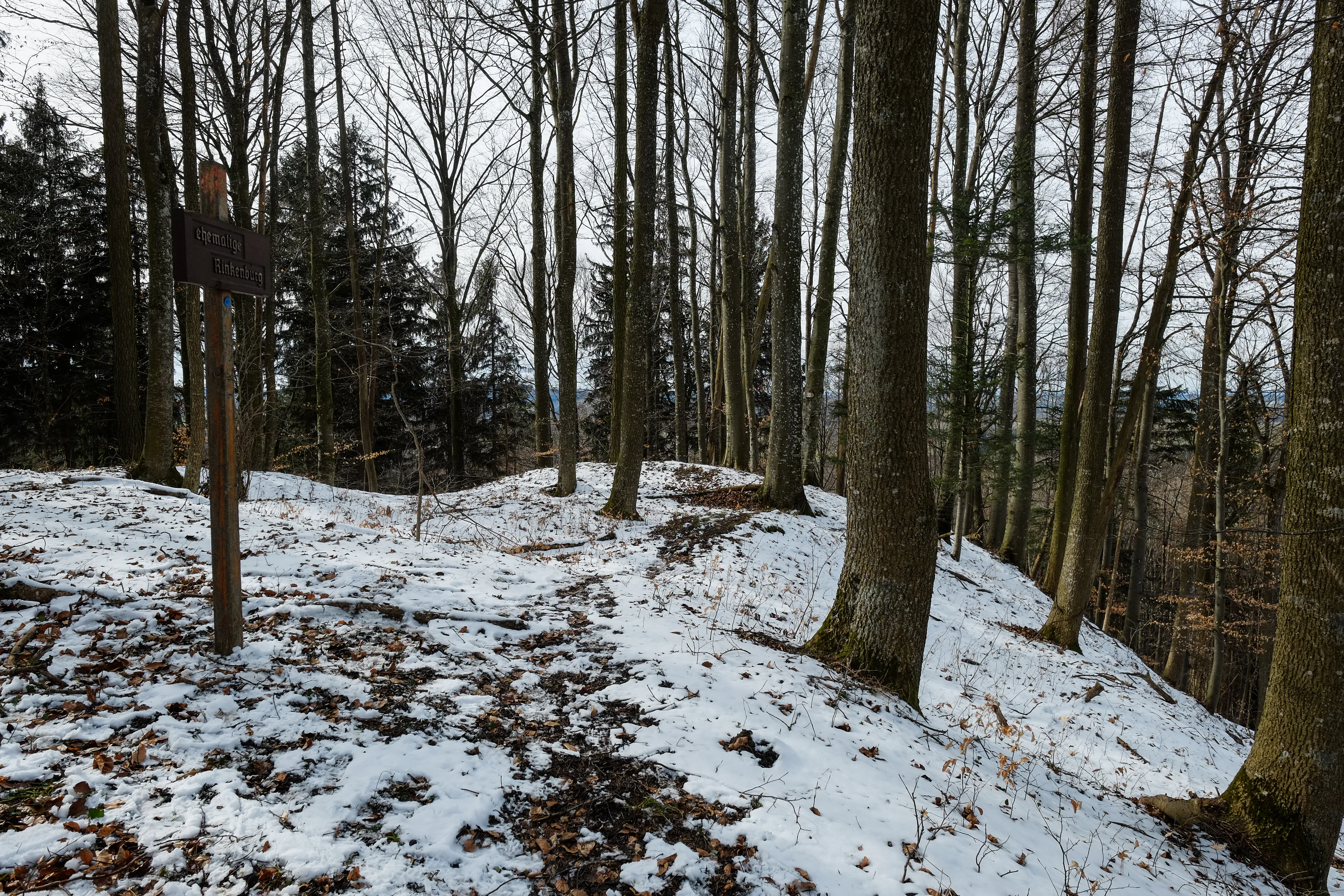
A snowy, sparse woodland with bare trees on a gentle slope, showing signs of a historical earthwork or site, with a wooden signpost on the left.
Winter view of the Rinkenburg historical site in the Pfrunger Ried protected area.

Pfrunger Ried, Rinkenburg history and protected-area timeline

Pfrunger Ried – Rinkenburg was formally designated as a landscape protection area on 23 October 1967, making it part of an early wave of systematic landscape protection efforts in Baden-Württemberg. Its establishment recognized both the geological significance of the glacial tongue basin that shapes the area and the ecological importance of its peat-forming wetlands.

The protection area was created to conserve a representative upper Swabian late glacial landscape, combining a kettle-like depression with extensive peat bogs and the Rinkenburg molasse hill. Over time, the significance of the area has been reinforced through overlapping designations such as a Bannwald forest reserve, dedicated nature protection areas including the Pfrunger-Burgweiler Ried and the Überwachsener See, as well as the Habitats Directive area Pfrunger Ried und Seen bei Illmensee. These layered designations reflect the growing recognition of the wetland system as a regionally and internationally important conservation site.

Pfrunger Ried, Rinkenburg landscape and geographic character

The defining landform of Pfrunger Ried – Rinkenburg is a former glacial tongue basin, a U-shaped depression carved during the ice ages that has since been filled in with peat-forming wetlands. Surrounding and underlying the basin is a typical upper Swabian late glacial meltwater landscape, with kettle-like depressions and undulating terrain shaped by retreating ice and meltwater flows.

Rising out of this wet lowland is the Rinkenburg, a Tertiary molasse hill that marks the resistant, older geology beneath the younger glacial and postglacial deposits. The hill reaches up to 726 meters above sea level, providing a significant contrast in elevation against the surrounding mires, which sit closer to 609 meters. This combination of low, saturated peatland and a harder, elevated molasse hill gives the protection area its characteristic relief and visual differentiation between wet and dry zones.

Pfrunger Ried, Rinkenburg ecosystems, habitats, and plant life

The ecological identity of Pfrunger Ried – Rinkenburg is built around large, connected mires, which dominate the flatter basin areas. These moors form the core of the Pfrunger-Burgweiler Ried, an extensive raised and transitional bog system recognized as the second-largest contiguous moorland complex in southwest Germany. The peat-forming conditions have created saturated soils, slow-moving water, and habitat mosaics typical of upper Swabian glacial basins.

The broader protected area also encompasses drier ecological zones on the Rinkenburg hill, where molasse bedrock supports different vegetation. The juxtaposition of these wet and dry habitats within a single protected area gives it a layered ecological character: nutrient-poor, waterlogged mire communities in the basin, and upland plant communities on the molasse hill. This habitat gradient is a key reason the area has been incorporated into multiple connected conservation designations, including Habitats Directive and bird protection areas.

Pfrunger Ried, Rinkenburg wildlife and species highlights

The wetland core of the Pfrunger-Burgweiler Ried provides habitat for mire-dependent fauna, including birdlife typically associated with large, undisturbed bog and reed complexes. The presence of an overlapping bird protection area, Vogelschutzgebiet Pfrunger und Burgweiler Ried, indicates that the site holds recognized value for breeding, resting, or migratory bird species tied to open moorland and wetland environments.

The combination of open mires, wet meadows, standing water bodies such as the nearby Überwachsener See, and the wooded higher ground of the Rinkenburg hill provides habitat diversity for both wetland-specialist and forest-associated species. While the source material available does not itemize specific species in detail, the layered conservation designations of the area suggest a fauna shaped strongly by both peatland and forest-edge species typical of upper Swabian glacial landscapes.

Pfrunger Ried, Rinkenburg conservation status and protection priorities

From a conservation standpoint, Pfrunger Ried – Rinkenburg is significant because it preserves one of the largest connected moorland complexes in southwest Germany within a single administrative protection framework. The designation ordinance explicitly identifies the protection of an ice-age tongue basin with mires and a typical upper Swabian meltwater landscape as the central purpose of the reserve, framing conservation in both geological and ecological terms.

Beyond its own landscape protection status, the area is embedded in a cluster of overlapping conservation designations. These include the Pfrunger-Burgweiler Ried nature protection area, the nearby Überwachsener See nature protection area, the Pfrunger-Burgweiler Ried Bannwald (strict forest reserve), the Altshausen-Laubbach-Fleischwangen landscape protection area, the Habitats Directive site Pfrunger Ried und Seen bei Illmensee, and the bird protection area Pfrunger und Burgweiler Ried. Together, these overlapping layers signal recognition of the site's importance at both regional Baden-Württemberg and European Union conservation levels.

Pfrunger Ried, Rinkenburg cultural meaning and human context

The protected area sits within the historically agricultural landscape of upper Swabia (Oberschwaben), a region long shaped by dairy farming, peat cutting, and traditional land management around its many mires. Communities such as Wilhelmsdorf, Esenhausen, and Pfrungen have long-standing relationships with these wet lowlands, both as a source of peat and fodder and as a setting for small-scale farming. The protection of the area reflects the modern shift away from these traditional extractive uses toward conservation of the mires as ecological heritage.

Top sights and standout views in Pfrunger Ried, Rinkenburg

Pfrunger Ried – Rinkenburg stands out for its rare combination of peat-forming glacial lowlands and a Tertiary molasse hill, producing a compact yet ecologically layered landscape. The fact that it encloses most of the Pfrunger-Burgweiler Ried places it among the most important moorland conservation sites. Its integration into multiple overlapping protection regimes underscores recognition of the area as a regionally and internationally valuable wetland system.

Best time to visit Pfrunger Ried, Rinkenburg

As a mires-dominated landscape in a relatively cool, elevated part of upper Swabia, the area is best appreciated when ground conditions are firm enough for walking without damaging sensitive vegetation. Late spring through early autumn tends to offer easier access to the bog edges and clearer views of the contrast between moorland and the molasse uplands. Winter visits can highlight the open, atmospheric character of the mires and their stillness, though visitors should rely on designated paths to avoid disturbing protected habitats.

Monthly climate preview

Long-term representative coordinate climatology for Pfrunger Ried Rinkenburg

Pfrunger Ried Rinkenburg Climate Normals, Annual Temperature and Precipitation Rhythm

Representative coordinate records show average monthly temperatures ranging from negative values in winter to highs near 28 degrees in warmer months alongside consistent precipitation values throughout the year. Examining the full twelve month climate profile provides complete numerical context for analyzing long-term atmospheric patterns at this protected location.
Annual mean8 °C
-2 °C18 °C
Jan-2°
Feb
Mar
Apr
May13°
Jun16°
Jul18°
Aug18°
Sep13°
Oct
Nov
Dec-1°
Warmest month
July

18 °C

Coolest month
January

-1.5 °C

Wettest month
July

3.9 mm/day

Driest month
February

1.9 mm/day

Park location guide

Geography guide, regional context, and park location map for Pfrunger Ried, Rinkenburg

Pfrunger Ried, Rinkenburg park geography, regions, and map view in Germany

Understand where Pfrunger Ried, Rinkenburg sits in Germany through a broader geographic reading of the surrounding landscape, nearby location context, and its mapped position within the national park landscape.

How Pfrunger Ried, Rinkenburg fits into Germany

Germany is a federal republic in Western and Central Europe with a population of over 83 million across sixteen constituent states. It is Europe's largest economy by nominal GDP and a major global exporter and importer. The capital is Berlin, and the country borders Denmark, Poland, Czech Republic, Austria, Switzerland, France, Luxembourg, Belgium, and the Netherlands.

Wider geography shaping Pfrunger Ried, Rinkenburg in Germany

Germany is located in Western and Central Europe, spanning 357,022 km². It borders Denmark to the north, Poland and the Czech Republic to the east, Austria and Switzerland to the south, and France, Luxembourg, Belgium, and the Netherlands to the west. The country has coastlines on the Baltic Sea and North Sea to the north, with the Alps located in the southern region.

Map view of Pfrunger Ried, Rinkenburg

Use this park location map to pinpoint Pfrunger Ried, Rinkenburg in Germany, understand its exact geographic position, and read its mapped placement within the surrounding landscape more clearly.

Pigeon | © OpenStreetMap contributors

Location context for Pfrunger Ried, Rinkenburg

Baden-Württemberg

Photographic records of glacial moorlands, peat bogs, and elevated molasse terrain.

Visual Exploration of Pfrunger Ried – Rinkenburg Landscapes and Scenery

Visual documentation captures the complex terrain of Pfrunger Ried – Rinkenburg, revealing the striking contrast between saturated glacial wetlands and the prominent Rinkenburg molasse hill. Examining these protected area photographs provides clear insight into the rare upper Swabian ice age landforms and diverse mire habitats.

A snowy, sparse woodland with bare trees on a gentle slope, showing signs of a historical earthwork or site, with a wooden signpost on the left.

Park atlas

Compare adjacent wetland reserves and regional glacial terrain across southern Germany

Explore Other Parks Near Pfrunger Ried – Rinkenburg and Surrounding Protected Landscapes

Users exploring Pfrunger Ried – Rinkenburg can browse adjacent protected areas, wetland reserves, and regional conservation zones. Comparing connected molasse hills and moorland habitats provides wider geographic context for upper Swabian ecosystems.
A horizontal watercolor painting depicting a soft-focus valley scene with rolling hills, scattered green trees, and a light sky.
Nature reserveBaden-Württemberg
About 7.1 km away#1 closest

Southwest

Deggenhauser Tal Nature Reserve: Mapped Geography and Protected Valley Landscapes

Glacial terrain and watershed ridges in Baden-Württemberg

Investigate the protected geography of Deggenhauser Tal, an expansive nature reserve in the Oberschwäbisches Hügelland. This record maps the complex network of stream corridors, steep valley slopes, and ridge heights that define this Natura 2000 protected area. Gain insights into the glacial relief and varied land use patterns that characterize this essential southwestern German valley ecosystem.

Area
8.492 km²
Established
2019
A soft, panoramic watercolor painting featuring green, rolling hills and a winding river or stream through a forested landscape against a bright, hazy sky.
Nature reserveBaden-Württemberg
About 16 km away#2 closest

East

Altdorfer Wald Nature Reserve: Geographic Atlas and Protected Landscape Overview

Mire, spring, and forest ecosystems in Baden-Württemberg

The Altdorfer Wald nature reserve consolidates a significant network of watercourses, peatlands, and old-growth forest stands across the Upper Swabian Pre-Alpine hills. This protected area stands as a primary focal point for understanding the interplay between hydrological richness, calcareous deposits, and diverse temperate forest habitats within the regional geography of Baden-Württemberg.

Area
13.71 km²
Established
2019
Relief
Upland
Climate
Temperate
Watercolor painting of a tranquil wetland landscape with pine trees, grassy shorelines, and distant rolling hills against a soft background.
Nature reserveBaden-Württemberg
About 18 km away#3 closest

Northeast

Feuchtgebiete um Bad Schussenried: Protected Wetland Mosaic and Regional Geography

Nature reserve complex in the Upper Swabian hill country

Feuchtgebiete um Bad Schussenried is an essential European FFH site spanning seven protected sub-areas. The landscape encompasses a dense patchwork of lowland fens, alder forests, and kettle-hole lakes, representing the unique glacial terrain of Upper Swabia through its intricate peatland and spring mire systems.

Area
6.1 km²
Established
2019
A horizontal watercolor painting showing a calm lake shore with green trees, reeds, and soft reflections on the water surface.
Nature reserveBaden-Württemberg
About 24 km away#4 closest

Southwest

Bodanrück und westl. Bodensee: Mapped Geography of an Extensive Nature Reserve

A glacial peninsula protected area in Baden-Württemberg

The Bodanrück und westl. Bodensee nature reserve represents a sprawling mosaic of ground moraines, drumlins, and kettle lakes along the shoreline of Lake Constance. This protected area supports a diverse array of habitats, from tufa-forming springs and alluvial forests to species-rich hay meadows, reflecting the complex ecological history of the German southwest.

Area
143.407 km²
Established
2004
Relief
Mixed relief
Climate
Temperate
Protected landscapeBaden-Württemberg
About 24 km away#5 closest

South

Württembergisches Bodenseeufer, Neufassung Teilbereich Friedrichshafen-West Protected Landscape

Mapped greenbelt corridor along the Lake Constance shoreline in Baden-Württemberg.

This protected landscape encompasses a vital 114-hectare corridor of lakeshore habitats and cultural land near Friedrichshafen. It preserves a critical mix of reed beds, shallow-water zones, and riparian woodland galleries that maintain the near-natural state of the Württemberg lakeshore. The area serves as a significant ecological bridge between the waters of Lake Constance and the urbanised inland terrain of the surrounding Bodenseekreis district.

Area
1.14 km²
Established
2004
Relief
Lowland
Scope
Mixed
Protected landscapeBaden-Württemberg
About 25 km away#6 closest

Northeast

Oberes Rißtal Protected Landscape: Glacial Geography and Wetland Corridors in Baden-Württemberg

Mapping the upper Riß river valley and its complex fen ecosystems

Oberes Rißtal stands as a crucial protected landscape in Baden-Württemberg, distinguished by its winding river meanders and multi-layered glacial terrain. This area merges the Riß and Würm ice-age legacy with active riparian habitats, including extensive lowland fens, kettle depressions, and traditional meadows. Explore the mapped boundaries and geographic features that define this essential Upper Swabian corridor.

Area
41.638 km²
Established
1975
IUCN
V
A soft watercolor painting of a rolling landscape featuring a winding river, grassy plains, and distant hills in muted green, pink, and yellow tones.
Protected landscapeBodenseekreis
About 28 km away#7 closest

Southeast

Spätwürmeiszeitliche Terrassen zwischen Burnau, Prestenberg, Vorderreute, Buch und Krumbach Geography

A protected landscape site in the Bodenseekreis district

Spätwürmeiszeitliche Terrassen zwischen Burnau, Prestenberg, Vorderreute, Buch und Krumbach is defined by its series of level river terraces resulting from Würm ice age glacial retreat. Spanning roughly 22 hectares near the Schwarzach river, the site remains a vital example of fluvioglacial geomorphology and regional landscape preservation within the pre-Alpine foreland.

Area
0.22 km²
Established
1963
Relief
Upland
Climate
Temperate
Protected landscapeBaden-Württemberg
About 29 km away#8 closest

Southeast

Tettnanger Wald mit Hochwacht, Krüntenbühl, Reichenbühl, Argenhardter Kopf, Schoos und Steilrand des Argentales an dem Schwandenbogen: Geography and Protected Boundaries

A Glacial Landscape Protection Area in the Lake Constance Basin

This protected landscape in Baden-Württemberg captures a classic moraine terrain shaped by glacial retreat. With its system of ridges, dead-ice hollows, and escarpments along the Argen valley, the area serves as a critical geological reference point. Explore the detailed topography and mapped boundaries of this forest landscape within the broader Bodenseebecken region.

Area
7.01 km²
Established
1954

Common questions about visiting, size, designation, and location context for Pfrunger Ried, Rinkenburg

Pfrunger Ried, Rinkenburg FAQs for park facts, access, geography, and protected area context

Find quick answers about Pfrunger Ried, Rinkenburg, including protected-area facts, park geography, trail and visitor context, and how the park fits into its surrounding country and regional landscape.
MoriAtlas Explorer

Continue Your Protected Areas Search Across the Global Atlas

Deepen your exploration by continuing the structured search for national parks and protected areas worldwide. Utilize the comprehensive filtering capabilities to compare different conservation landscapes and refine your understanding of global park geography. Discover more about the distribution and characteristics of protected natural areas.

Global natural geography