Mori Atlas logo
State or regional parkPorcupine Meadows Provincial Park

Mapping the sub-alpine meadows, old growth forests, and wetland complexes of the Bonaparte Plateau

Porcupine Meadows Provincial Park: High-Elevation Protected Landscapes in British Columbia

Porcupine Meadows Provincial Park encompasses a significant high-elevation upland landscape on the Bonaparte Plateau in south-central British Columbia. This wilderness-oriented protected area features extensive sub-alpine meadows, interconnected wetland systems, and tracts of old growth forest that define its unique ecological character. Serving as the highest geographic point between Kamloops and 100 Mile House on the west side of the North Thompson River, the park offers a distinct interior plateau terrain far removed from traditional valley environments.

sub-alpine meadowswetlandsold growth forestBonaparte Plateauinterior British Columbiawilderness park

Porcupine Meadows Provincial Park

State or regional park

Park overview

Structured park overview, official facts, and landscape profile for Porcupine Meadows Provincial Park

Porcupine Meadows Provincial Park park facts, protected area profile, and essential visitor context

Review the core facts for Porcupine Meadows Provincial Park, including designation, size, terrain, visitor scale, habitats, and operating context in one park-focused overview.

About Porcupine Meadows Provincial Park

Porcupine Meadows Provincial Park is one of British Columbia's interior sub-alpine protected areas, defined less by dramatic peaks and more by the quiet expanse of its high-elevation terrain. Covering roughly 2,704 hectares on the southern reaches of the Bonaparte Plateau, the park lies northwest of Kamloops and west of the North Thompson River, occupying a transitional zone between the dry interior valleys to the south and the more forested plateau country extending toward 100 Mile House. Its ecological importance lies in the mix of open and forested habitats that develop at higher elevations within an otherwise semi-arid interior region.

The landscape is shaped by sub-alpine wetlands, broad meadows, and old growth forest stands, producing a mosaic of habitats uncommon in the surrounding dry belt of south-central British Columbia. Because the park lies at the highest elevation along the route between Kamloops and 100 Mile House, it gathers greater moisture than lower terrain nearby, supporting wetter vegetation communities than visitors might expect from the region's general climate. This high-country character is central to the identity of Porcupine Meadows and separates it from the lakeside and river-oriented parks common elsewhere in the Kamloops area.

Wilderness conditions define the visitor experience. There are no formal facilities within the park, and an old forestry lookout serves mainly as an emergency shelter rather than a developed visitor site. Access is from the southeast via the Watching Creek Forest Service Road, and once inside, the park is traversed only by non-motorized means such as hiking, horseback riding on designated trails, snowshoeing, and winter snowmobile use. This limited infrastructure reinforces the park's value as a quiet, relatively undisturbed area for backcountry-style exploration, ecological observation, and wildlife encounters rather than as a conventional day-use destination.

Quick facts and research context for Porcupine Meadows Provincial Park

Porcupine Meadows Provincial Park is a 2,704 hectare protected area in south-central British Columbia, located northwest of Kamloops on the southern Bonaparte Plateau. It was established on April 30, 1996, and is administered by BC Parks under an IUCN Category II designation equivalent to that of a national park.

The park sits at the highest point between Kamloops and 100 Mile House on the west side of the North Thompson River. Its dominant environments are sub-alpine wetlands, meadows, and old growth forest. Access is via the Watching Creek Forest Service Road, with no motorized internal routes except winter snowmobile use, and the park has no formal visitor facilities.

Protection and recognition

Documented terrestrial protection scope and international recognition facts

Porcupine Meadows Provincial Park Protection Status and Recognition

Porcupine Meadows Provincial Park maintains a documented terrestrial protection scope without supplementary international recognition sources. Comprehensive protection status records outline official management parameters and administrative designations for the landscape.

Protection details

Protection scope
Terrestrial
Transboundary protection
No
Park context

Deeper park guide and search-rich context for Porcupine Meadows Provincial Park

Porcupine Meadows Provincial Park history, landscape, wildlife, and travel context

Explore Porcupine Meadows Provincial Park through its history, landscape character, ecosystems, wildlife, conservation priorities, cultural context, and seasonal travel timing in a structured park guide built for atlas discovery and search intent.

Why Porcupine Meadows Provincial Park stands out

Porcupine Meadows Provincial Park is especially known for its extensive sub-alpine wetland and meadow complexes set within a high-elevation interior landscape. These open habitats, interspersed with old growth forest stands, define the park's ecological identity and make it a recognized area for birdlife and large mammals such as moose and mule deer. The park is also notable for its position as the highest point between Kamloops and 100 Mile House on the west side of the North Thompson River, giving it an unusually exposed sub-alpine character for its latitude and region in British Columbia. Its Shuswap-language name, pisitsoolsia, reflects the area's longstanding cultural association with porcupines and adds a distinctive indigenous linguistic identity to the park.

Porcupine Meadows Provincial Park history and protected-area timeline

Porcupine Meadows Provincial Park was established on April 30, 1996, through the British Columbia provincial park system managed by BC Parks. Its designation brought formal protection to a high-elevation area that had previously been shaped more by historical human passage than by sustained settlement. Long before the park existed, the area functioned as a pack-trail corridor linking Pass Lake and Porcupine Ridge, indicating that it served as a travel route through the Bonaparte Plateau rather than as a place of permanent habitation.

By the time of its establishment, the surrounding land had become subject to forestry activity, while the park itself was set aside to preserve its sub-alpine meadows, wetlands, and old growth forest. The name Porcupine Meadows itself carries older cultural depth: it is a direct translation of the Shuswap word pisitsoolsia, reflecting the long presence of porcupines in the area and the indigenous Shuswap naming of the landscape. Since its 1996 designation, the park has remained a lightly developed wilderness-style protected area, with logging pressure around its boundaries influencing trail conditions within but not altering its basic protected status.

Porcupine Meadows Provincial Park landscape and geographic character

Porcupine Meadows Provincial Park occupies a high-elevation stretch of the southern Bonaparte Plateau, a broad upland surface in south-central British Columbia. The terrain reaches the highest point between Kamloops and 100 Mile House on the west side of the North Thompson River, giving the park a distinctly upland character compared with the lower, drier valleys that dominate much of the surrounding region. This elevation makes the landscape feel more open and exposed than the typical interior British Columbia setting.

Within the park, the dominant physical features are extensive sub-alpine meadows and wetlands set against tracts of old growth forest. The meadows form broad open expanses interspersed with wet depressions and boggy ground, while the forested sections include mature coniferous stands that frame and break up the open country. The combination creates a varied ground surface of grassy flats, marshy hollows, forest edges, and gentle high-plateau relief rather than a terrain of sharp peaks or deep valleys.

Because the Bonaparte Plateau receives moisture orographic influence at elevation, the park supports wetter ground conditions than the dry belts below. The result is a landscape where open sub-alpine vistas meet quiet wetland textures, and where the boundaries between meadow, wetland, and forest shift gradually across the terrain. The absence of major rivers or large lakes inside the park enhances the sense of an expansive plateau landscape shaped by gentle relief, moisture, and vegetation rather than by dramatic topography.

Porcupine Meadows Provincial Park ecosystems, habitats, and plant life

The ecological identity of Porcupine Meadows Provincial Park is built around its sub-alpine meadow and wetland systems, which are uncommon in the surrounding dry interior of south-central British Columbia. At its elevation on the Bonaparte Plateau, the park collects enough moisture to sustain open wet habitats, creating ecological conditions quite different from the semi-arid grasslands and pine forests that dominate much of the Kamloops region. These wetter conditions are the foundation of the park's biodiversity.

The vegetation mosaic includes extensive sub-alpine meadows, wetland vegetation in flatter and lower-lying areas, and mature old growth forest stands, often dominated by conifers adapted to cooler, moister interior conditions. This combination of meadow, wetland, and forest creates multiple ecological niches within a relatively compact area. The older forest stands in particular contribute structural complexity to the landscape, providing habitat contrasts with the open meadows that few other regional parks offer at this elevation.

Together, these habitat types form an ecologically valuable interior highland complex. The wetlands act as natural water retention zones on the plateau, the meadows support grazing and browsing conditions for mammals, and the old growth patches provide shelter and continuity for forest-dependent species. The interplay between these environments is what gives Porcupine Meadows its distinctive ecological character within the broader context of British Columbia's interior parks.

Porcupine Meadows Provincial Park wildlife and species highlights

Wildlife observation is one of the strongest reasons Porcupine Meadows Provincial Park stands out among interior British Columbia parks, owing to the mix of meadow, wetland, and old growth forest habitats available there. The wetlands and meadows in particular draw a variety of birdlife, with sandhill cranes identified as a notable species in the area. Their presence reflects the value of the park's open, moist habitat for migratory and breeding birds that require shallow or grassy wetland environments.

Larger mammals also make use of the park's habitats. Moose are associated with the wetland and meadow zones, where aquatic vegetation and shrub cover provide both forage and shelter, while mule deer frequent the open meadows and forest edges. The combination of browse-rich meadows, wet depressions, and forested patches supports a mammal community typical of the sub-alpine interior plateau, where animals can move between feeding habitats and cover.

The park also retains its namesake animal. Porcupines continue to inhabit the area in significant numbers, as they have historically, contributing both to the park's ecological profile and to the origin of its name. Together, the birdlife, ungulates, and characteristic small mammals give Porcupine Meadows a recognizable interior wildlife identity, supported by habitat diversity rather than by sheer species richness alone.

Porcupine Meadows Provincial Park conservation status and protection priorities

Porcupine Meadows Provincial Park plays a meaningful conservation role in south-central British Columbia by safeguarding a high-elevation mosaic of sub-alpine wetlands, meadows, and old growth forest on the southern Bonaparte Plateau. These habitats are not abundant in the surrounding dry interior landscape, where lower elevations are dominated by different vegetation communities and land uses. Protecting this elevated wet-and-open complex contributes to landscape-level ecological diversity in the region.

The park's protected status also preserves old growth forest stands that might otherwise be vulnerable to forestry pressure. Although logging activity occurs around the boundaries of the park, influencing trail conditions within, the core habitats of the meadows and wetlands remain sheltered from direct industrial use. Wilderness-style management, including restrictions on motorized through-access, helps maintain the integrity of these habitats for wildlife and ecological processes.

Its recognition as an IUCN Category II protected area, equivalent to a national park designation, underlines the significance attributed to the landscape at a policy level. For a region where human land use is intensive, the existence of a relatively undisturbed sub-alpine protected area enhances ecological connectivity and preserves habitat conditions for species such as sandhill cranes, moose, mule deer, and porcupines that depend on this kind of interior highland environment.

Porcupine Meadows Provincial Park cultural meaning and human context

The cultural identity of Porcupine Meadows Provincial Park is rooted primarily in the Shuswap language and the indigenous knowledge of the landscape that long predates its 1996 designation. The park's English name is a direct translation of the Shuswap word pisitsoolsia, demonstrating that the area was a known and named place within Secwepemctsín (the Shuswap language) well before it became a provincial park. The Shuswap name itself reflects the longstanding ecological reality of an area rich in porcupines, indicating a familiar animal presence in traditional place-naming practices.

Beyond indigenous naming, the park's historical human use has been minimal and transient rather than settlement-based. The area once functioned as a pack-trail corridor linking Pass Lake and Porcupine Ridge, suggesting occasional use for travel, hunting, or seasonal activity rather than continuous habitation. Today, the park remains unsettled, and cultural association with the land continues largely through its indigenous linguistic heritage and through its present identity as a quiet wilderness landscape within British Columbia's provincial park system.

Top sights and standout views in Porcupine Meadows Provincial Park

The defining highlights of Porcupine Meadows Provincial Park include its status as the highest-elevation point between Kamloops and 100 Mile House on the west side of the North Thompson River, and the unusually well-developed sub-alpine meadow and wetland systems that come with that elevation. These open, moist habitats, ringed and interspersed with old growth forest, create a landscape quite distinct from the drier valley parks common elsewhere in the Kamloops region.

Wildlife encounters reinforce the park's appeal: sandhill cranes use the open country, moose and mule deer move between meadow and forest edges, and porcupines remain a visible presence that helped name the area in the Shuswap language. Combined with a wilderness-style management approach featuring no formal facilities, restricted motorized access, and the presence of long hiking trails such as the Masters Sub-alpine Trek, these features give Porcupine Meadows a clear identity as a backcountry-oriented interior park shaped more by ecological character than by visitor infrastructure.

Best time to visit Porcupine Meadows Provincial Park

The character of a visit to Porcupine Meadows Provincial Park changes meaningfully with season, and the timing of a trip should match the kind of experience a visitor is looking for. Summer is generally the most accessible period for exploring the meadows and wetlands on foot or on horseback, when the sub-alpine meadows are at their most visible and birdlife, including sandhill cranes, is most active across the open landscape. Warmer months also make the Watching Creek Forest Service Road approach more usable for visitors without specialized equipment.

Winter transforms the park into a snow-oriented environment. Snowmobile access becomes the main motorized route through the area, and snowshoeing offers a quieter alternative for moving across the high plateau. Snow cover alters the visibility of meadows and wetlands but brings out a different kind of landscape character, and the cold-season conditions emphasize the park's wilderness quality. Shoulder seasons can also be attractive, though access via forest service roads and trail conditions may be more variable, and visitors should expect a more rugged experience than at lower-elevation parks in the region.
Monthly climate preview

Long-term representative temperature ranges and monthly precipitation data

Porcupine Meadows Provincial Park Climate Normals and Annual Weather Patterns

Representative coordinate measurements reveal measured annual temperature variations and monthly precipitation rhythms across Porcupine Meadows Provincial Park. Examining the comprehensive twelve-month climatology dataset clarifies detailed shifts in long-term averages.
Annual mean3 °C
-9 °C16 °C
Jan-9°
Feb-7°
Mar-2°
Apr
May
Jun12°
Jul16°
Aug16°
Sep10°
Oct
Nov-4°
Dec-9°
Warmest month
July

16.2 °C

Coolest month
January

-9.2 °C

Wettest month
June

2 mm/day

Driest month
April

1.1 mm/day

Park location guide

Geography guide, regional context, and park location map for Porcupine Meadows Provincial Park

Porcupine Meadows Provincial Park park geography, regions, and map view in Canada

Understand where Porcupine Meadows Provincial Park sits in Canada through a broader geographic reading of the surrounding landscape, nearby location context, and its mapped position within the national park landscape.

How Porcupine Meadows Provincial Park fits into Canada

Canada is a federal parliamentary constitutional monarchy spanning North America from the Atlantic to the Pacific and Arctic Oceans. With a population of over 41 million, it is officially bilingual in English and French at the federal level. The country gained independence from the United Kingdom through a gradual process culminating in 1982.

Wider geography shaping Porcupine Meadows Provincial Park in Canada

Canada occupies the northern portion of North America, sharing its longest international border with the United States. The country extends from the Atlantic Ocean to the Pacific Ocean and northward into the Arctic Ocean, giving it the longest coastline of any nation.

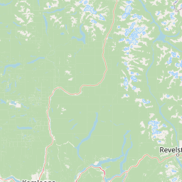
Map view of Porcupine Meadows Provincial Park

Use this park location map to pinpoint Porcupine Meadows Provincial Park in Canada, understand its exact geographic position, and read its mapped placement within the surrounding landscape more clearly.

Pigeon | © OpenStreetMap contributors

Location context for Porcupine Meadows Provincial Park

British Columbia
Park atlas

Compare adjacent interior plateau protected areas and high elevation wilderness terrain

Parks Near Porcupine Meadows Provincial Park And Surrounding Protected Landscapes

Browsing other protected areas near Porcupine Meadows Provincial Park reveals the broader ecological patterns of the Bonaparte Plateau region. Comparing adjacent interior plateau reserves provides deeper geographic context for understanding high elevation sub alpine ecosystems.
A horizontal watercolor illustration depicting gentle green hills, a small grove of trees, and a pale ground plane against a white background.
Protected areaBritish Columbia
About 24 km away#1 closest

South

Lac du Bois Grasslands Protected Area: Mapped Geography and Interior Plateau Landscapes

Exploring dryland ecosystems and native prairies in British Columbia.

Located in the Thompson-Nicola Regional District, this protected area spans over fifteen thousand hectares of rolling hills and elevated rocky benches. It remains a flagship example of interior plateau conservation, preserving a unique ecological gradient that stretches from arid sagebrush-covered terrain up into denser montane coniferous forest communities.

Area
157.12 km²
Established
1996
IUCN
II
Relief
Upland
A watercolor illustration showing a river winding through a valley with soft colored hills, a sandy bank in the foreground, and sparse trees along the shore.
State or regional parkBritish Columbia
About 43 km away#2 closest

Southwest

Juniper Beach Provincial Park: Geography and Protected Landscapes in British Columbia

Arid sagebrush steppe along the Thompson River corridor

Juniper Beach Provincial Park preserves a specialized pocket of desert ecology within British Columbia. Spanning 260 hectares, the area features a flat riverfront beach, steep bluffs, and open sagebrush slopes. This protected landscape offers a study in interior plateau geography, bridging the gap between riparian river systems and the dry, sun-exposed terrain of the Thompson Country.

Area
2.6 km²
Established
1989
IUCN
II
Relief
Lowland
State or regional parkBritish Columbia
About 82 km away#3 closest

West

Marble Canyon Provincial Park: A Geological Exploration of British Columbia's Limestone Terrain

Mapping the canyons, mountain lakes, and microbialite ecosystems of the Marble Range.

Marble Canyon Provincial Park provides a dense concentration of natural features in British Columbia. The area protects a deep, river-carved limestone gorge, surrounding mountain slopes, and the distinct carbonate structures of Pavilion Lake. This site serves as a vital natural laboratory for geological and scientific research while offering an accessible landscape of cliffs and clear interior waters.

Area
25.44 km²
Established
1956
IUCN
II
Relief
Mountain
State or regional parkBritish Columbia
About 87 km away#4 closest

West

Edge Hills Provincial Park: Mapping the Fraser Canyon and Interior British Columbia Geography

A remote protected fore-range between canyon and mountain

Edge Hills Provincial Park offers a study in interior British Columbia topography, where dramatic vertical relief from the Fraser River canyon meets high-elevation rolling hills. This undeveloped preserve highlights the transition between coniferous forests and dry grasslands, providing a distinct geographic perspective for those interested in Canadian protected landscapes and rugged mountain terrain.

Area
118.82 km²
Established
1995
IUCN
II
Relief
Mountain
A watercolor painting showing a serene lake view with forested shoreline, grassy foreground, and rolling mountains in the distance, set against a soft, light background.
State or regional parkBritish Columbia
About 110 km away#5 closest

East

Mara Provincial Park: Protected Shoreline and Geographic Features in British Columbia

Mapping the Shuswap region's essential day-use lakeshore environment

Situated on the southern edge of Mara Lake, Mara Provincial Park functions as a key protected site in the Shuswap region of British Columbia. This area provides public access to sandy beaches and serves as the primary boat launch for the surrounding interior lake system, preserving natural terrain against private lakeshore development.

Area
0.05 km²
Established
1958
IUCN
II
Relief
Lowland
A watercolor painting showing a soft landscape with rolling hills, a winding stream or lake, and grassy vegetation.
State or regional parkBritish Columbia
About 119 km away#6 closest

South

Kentucky Alleyne Provincial Park: Glacial Landscapes and Interior Protected Areas

Mapping kettle lake geography in the British Columbia interior

Kentucky Alleyne Provincial Park preserves a compact, richly varied landscape of kettle lakes, eskers, and dry interior forest. Located in the Nicola region of British Columbia, this protected area offers a clear look at glacial landforms and sun-warmed Ponderosa pine woodlands, standing as a distinct geographic landmark within the Canadian interior range country.

Area
1.9 km²
Established
1981
IUCN
II
Relief
Upland
State or regional parkBritish Columbia
About 127 km away#7 closest

Southeast

Kalamalka Lake Provincial Park and Protected Area: Mapped Geography and Regional Context

A conservation landscape of the North Okanagan valley

Kalamalka Lake Provincial Park and Protected Area preserves 978 hectares of essential grassland and lakeshore habitats in British Columbia. The area features a complex mosaic of open meadows and mixed forest stands, offering a detailed perspective on the ecological transitions found within the Okanagan Valley. Its geography is defined by the shimmering turquoise waters of Kalamalka Lake, reflecting the unique interplay between seasonal mineral shifts and the surrounding arid terrain.

Area
9.78 km²
Established
1975
IUCN
II
Relief
Upland
A panoramic watercolor illustration depicting rolling green and lavender hills with dark green conifer tree silhouettes in the foreground under a pale pink sky
Protected landscapeBritish Columbia
About 149 km away#8 closest

Northwest

Churn Creek Protected Area: Geography and Mapped Landscapes of the Chilcotin Plateau

Dryland canyon systems and open grassland ecosystems in British Columbia

Spanning over 36,000 hectares, Churn Creek Protected Area preserves an unusual interior dryland environment defined by bluebunch wheatgrass steppe and sagebrush communities. The area sits where the Chilcotin Plateau meets the Fraser River, creating a mosaic of benches, hoodoos, and deep drainages that transition into the Camelsfoot Range.

Area
367.47 km²
Established
1995
IUCN
VI
Relief
Mixed relief

Common questions about visiting, size, designation, and location context for Porcupine Meadows Provincial Park

Porcupine Meadows Provincial Park FAQs for park facts, access, geography, and protected area context

Find quick answers about Porcupine Meadows Provincial Park, including protected-area facts, park geography, trail and visitor context, and how the park fits into its surrounding country and regional landscape.
MoriAtlas Explorer

Continue Your Protected Areas Search Across the Global Atlas

Deepen your exploration by continuing the structured search for national parks and protected areas worldwide. Utilize the comprehensive filtering capabilities to compare different conservation landscapes and refine your understanding of global park geography. Discover more about the distribution and characteristics of protected natural areas.

Global natural geography