

Mori Atlas logo
Nature reservePotamos Gialias

Analyzing the ecological corridors, riparian habitats, and riverine geography of this protected area.

Potamos Gialias Nature Reserve: A Detailed Map and Protected Landscape Overview in Cyprus

Potamos Gialias serves as a significant protected nature reserve within central-eastern Cyprus, centered on the Yalias River corridor. This site hosts a concentrated gradient of Mediterranean habitats, ranging from intermittent riverbeds and gallery forests of white willow and poplar to pine woodlands and rocky chasmophytic slopes. By safeguarding these diverse terrain types, the reserve acts as a critical link between inland agricultural landscapes and upland ecosystems, supporting numerous bird species and sensitive faunal groups in the eastern Mediterranean.

river valleyMediterranean habitatsriparian forestgallery forestintermittent riverphrygana shrubland

Potamos Gialias

Nature reserve

Park overview

Structured park overview, official facts, and landscape profile for Yalias River

Yalias River park facts, protected area profile, and essential visitor context

Review the core facts for Yalias River, including designation, size, terrain, visitor scale, habitats, and operating context in one park-focused overview.

About Yalias River

Potamos Gialias is a protected riverine landscape in central-eastern Cyprus that captures a complete cross-section of Mediterranean lowland and valley ecology in a relatively compact footprint. The site follows the course of the Yalias River through the country's interior, anchoring a corridor of natural vegetation between surrounding agricultural land and higher forested terrain. Its designation as a Natura 2000 Site of Community Importance highlights the European conservation value of Mediterranean river systems, which are among the most threatened ecosystems in the region.

The protected area includes ten natural habitat types that span the typical ecological gradients of eastern Mediterranean valleys. Along the riverbed itself, intermittent flows support the distinctive Paspalo-Agrostidion habitat, while the banks and immediate riparian zone are lined with gallery forests of white willow (Salix alba) and white poplar (Populus alba). Southern riparian thickets typical of the region (Nerio-Tamaricetea and Securinegion tinctoriae communities) fringe these forest galleries, creating transitional layers between aquatic, wetland, and terrestrial environments.

Beyond the river, the surrounding slopes carry thermo-Mediterranean shrublands, arborescent matorral with Ziziphus, Sarcopoterium spinosum phryganas, pseudo-steppe grasslands of the Thero-Brachypodietea class, and moisture-retaining Molinio-Holoschoenion meadows. Mediterranean pine forests with endemic mesogean pines occupy more elevated terrain within the site, while siliceous rocky outcrops support specialized chasmophytic plant communities. This habitat diversity, packed into a small territorial area, is what gives the site its disproportionate ecological importance.

Faunal diversity within the site is equally striking for its size. The designation document lists 53 protected bird species, 2 protected mammal species, and 2 protected reptile species as the primary basis for conservation. Birds recorded include Mediterranean specialists such as the European roller (Coracias garrulus), the European bee-eater (Merops apiaster), the great spotted cuckoo (Clamator glandarius), various herons and egrets, harriers, falcons, warblers, and several wheatears. The site also supports the lesser horseshoe bat (Rhinolophus hipposideros) and the Egyptian fruit bat (Rousettus aegyptiacus), as well as the western Caspian turtle (Mauremys rivulata) and the Cypriot grass snake (Natrix natrix cypriaca). Additional observations include amphibians, reptiles, and plants beyond the listed protected species, reinforcing the site's value as a living reservoir of Cypriot biodiversity.

Quick facts and research context for Yalias River

Potamos Gialias is a Natura 2000 Site of Community Importance located in central-eastern Cyprus, centered on the Yalias River at approximately 34.98°N, 33.33°E. The total area of the site is about 93 hectares, with the protection status applying entirely to terrestrial land along the river corridor. It was designated under the EU Habitats Directive (92/43/EEC) to conserve ten natural habitat types and 57 protected animal species, the great majority of which are birds. The site is embedded in the broader Mediterranean ecoregion and represents one of the small but ecologically concentrated protected river valleys recognized across the island.

Protection and recognition

Terrestrial conservation framework, designation history, and management scope

Potamos Gialias Protection Status and International Recognition Data

Potamos Gialias preserves a documented terrestrial protection scope without imported international recognition sources or transboundary records. Official conservation parameters provide structured baseline facts regarding land management and protective boundaries.

Protection details

Protection scope
Terrestrial
Park context

Deeper park guide and search-rich context for Yalias River

Yalias River history, landscape, wildlife, and travel context

Explore Yalias River through its history, landscape character, ecosystems, wildlife, conservation priorities, cultural context, and seasonal travel timing in a structured park guide built for atlas discovery and search intent.

Why Yalias River stands out

Potamos Gialias is best known for harboring a compact yet unusually rich concentration of Mediterranean riverine habitats in a single small protected corridor. The site is particularly notable for its intermittent Mediterranean river habitat with Paspalo-Agrostidion vegetation, its willow and poplar gallery forests, and its southern riparian thickets. It is also distinguished by the large number of protected bird species recorded on site, including several migratory, wetland-associated, and Mediterranean-endemic species such as the Cyprus wheatear (Oenanthe cypriaca).

Yalias River history and protected-area timeline

Potamos Gialias was formally designated as a Special Area of Conservation under the European Union Habitats Directive (Directive 92/43/EEC) of 1992, which seeks to conserve natural habitats, wild fauna, and wild flora across the European Union. The designation process recognized the site for harboring ten natural habitat types and 57 protected animal species, especially birds, that require coordinated protection at the European level. The site's inclusion in Cyprus's Natura 2000 network followed the country's integration into this conservation framework and reflects the broader effort to safeguard representative Mediterranean river ecosystems. Unlike older park-style reserves, the site's history is primarily that of a regulatory and ecological designation tied to European conservation law rather than to a long national-park tradition.

Yalias River landscape and geographic character

The landscape of Potamos Gialias is shaped by the valley of the Yalias River and the surrounding Mediterranean hillslopes of central-eastern Cyprus. The river itself follows an intermittent flow pattern typical of the region, with periods of low or dry water alternating with seasonally higher runoff. Along the riverbed, the open channel transitions into fringing galleries of tall white willows and white poplars, which form the most visually distinctive feature of the valley.

Away from the watercourse, the terrain rises into low hills carrying Mediterranean pine woodland, particularly stands with endemic mesogean pines, and siliceous rocky slopes with crevice-dwelling chasmophytic vegetation. Broader flatter areas support dense shrubby formations of Ziziphus matorral, low phrygana dominated by Sarcopoterium spinosum, and expanses of pseudo-steppe grasslands. Moist depressions and seepage zones along the valley floor sustain the tall-herb Molinio-Holoschoenion meadows, which contrast with the drier surrounding garrigue and give the site its layered, multi-textured appearance.

Yalias River ecosystems, habitats, and plant life

Ecologically, Potamos Gialias is a textbook example of how Mediterranean river valleys concentrate habitat diversity into a small area. The site captures nearly the full vertical and lateral gradient of eastern Mediterranean lowland ecosystems in a single narrow corridor, from the riverbed through riparian forests, southern riparian thickets, tall-herb meadows, and shrublands, up into Mediterranean pine forest on the surrounding slopes.

The intermittent river habitat with Paspalo-Agrostidion communities is a particularly rare and threatened habitat type characteristic of seasonal Mediterranean watercourses. Where water persists or subsurface moisture remains, the gallery forests of willow and poplar, combined with Nerio-Tamaricetea and Securinegion tinctoriae thickets, stabilize the banks and create microclimatic refuges for wildlife during hot, dry summers. The combination of phrygana, matorral, pseudo-steppe, and pine forest in close proximity gives the site a mosaic character that supports species with very different ecological preferences side by side.

Yalias River wildlife and species highlights

The wildlife profile of Potamos Gialias is dominated by its exceptional bird richness, which is disproportionately high for the site's relatively small territorial extent. The official designation cites 53 protected bird species as a basis for the site's conservation, including breeding Mediterranean species, passage migrants, and winter visitors that use the river corridor as a habitat and movement route.

Among the more distinctive species are the European roller, a colorful summer visitor that depends on open countryside with scattered trees; the European bee-eater, which nests in colonies along river banks; the great spotted cuckoo, a brood parasite associated with Mediterranean landscapes; and several herons and egrets that exploit the river and wet meadows. Raptors on site include the long-legged buzzard, hen harrier, marsh harrier, and pallid harrier, while owls are represented by the barn owl. The site also hosts the Cyprus wheatear, a regionally important passerine.

Beyond birds, the protected area harbors two mammal species of conservation concern: the lesser horseshoe bat, a cave- and foliage-dwelling species sensitive to roost disturbance, and the Egyptian fruit bat, the only fruit bat species found in Europe. Reptiles include the western Caspian terrapin (Mauremys rivulata), an aquatic freshwater turtle tied to Cyprus's rivers and streams, and the Cypriot subspecies of the grass snake (Natrix natrix cypriaca), an endemic island form. Additional amphibians, reptiles, and plants observed on site further extend the site's biodiversity value beyond the strict protected-species list.

Yalias River conservation status and protection priorities

Potamos Gialias is a conservation anchor for one of the few remaining Mediterranean lowland river systems in Cyprus that retains a connected sequence of natural riparian habitats. Its designation under the Habitats Directive explicitly targets the protection of intermittent Mediterranean rivers, gallery forests, and thermo-Mediterranean shrubland communities that have been heavily reduced across the Mediterranean basin through water abstraction, damming, agricultural expansion, and urbanization. By formally recognizing the site, the directive commits to maintaining the ecological condition of these habitats and the species that depend on them.

The site's particular conservation value lies in the overlap of aquatic, riparian, woodland, and dryland habitats on a small land base, which makes it a high-efficiency refuge for biodiversity. Maintaining functional hydrology of the Yalias River, protecting the integrity of gallery forests and riparian thickets, and preventing further encroachment or degradation of the surrounding shrublands and pine stands are central to preserving the site's ecological coherence. As a Natura 2000 site, Potamos Gialias also connects Cyprus's conservation network with broader European efforts to safeguard Mediterranean biodiversity under climate and land-use pressures.

Top sights and standout views in Yalias River

Among Potamos Gialias's most compelling features is the way a single small river valley concentrates an entire Mediterranean ecological gradient, from intermittent riverbed habitats through willow-poplar galleries and southern riparian thickets to phrygana, matorral, pseudo-steppe, Mediterranean pine forest, and rocky chasmophytic slopes. The site's bird list is similarly outsized, with 53 protected bird species highlighted in the official designation, including charismatic species such as the European roller, the European bee-eater, and the Cyprus wheatear. The combination of protected freshwater turtle, endemic grass snake subspecies, and two protected bat species adds a further layer of faunal importance. As a Natura 2000 Site of Community Importance embedded in Cyprus's Natura 2000 network, Potamos Gialias represents a small but strategically valuable piece of the European Union's effort to safeguard Mediterranean river and valley ecosystems.

Best time to visit Yalias River

The most balanced time to experience the valley of the Yalias River is spring and early autumn, when Mediterranean temperatures are moderate and the river corridor combines green riparian vegetation with active wildlife. Spring is particularly favorable for birds, when migratory species, breeding rollers, bee-eaters, and a wide range of warblers and wheatears are present, and when the surrounding phrygana, matorral, and pine habitats are most floristically expressive. Early autumn offers a quieter window with continued warm conditions and reliable bird presence, while high summer tends to bring intense heat, dry riverbed conditions, and reduced animal activity, though the hardy shrubland and pine communities remain visually distinctive year-round. As a small riverine Natura 2000 site rather than a developed visitor destination, the site is best appreciated as part of broader lowland and valley exploration rather than as a single seasonal attraction.
Monthly climate preview

Long-term representative measurements showing monthly temperature and precipitation cycles

Potamos Gialias Climate Normals, Annual Temperature and Precipitation Rhythm

Potamos Gialias exhibits a measured annual cycle defined by average monthly temperatures ranging from 10.45 degrees Celsius to 29.81 degrees Celsius alongside varying precipitation rates from 0.02 mm per day to 2.66 mm per day. Examining the complete twelve-month climatology dataset reveals broader trends across the representative coordinate without relying on live forecasts.
Annual mean20 °C
10 °C30 °C
Jan10°
Feb11°
Mar13°
Apr17°
May22°
Jun27°
Jul30°
Aug30°
Sep27°
Oct22°
Nov17°
Dec12°
Warmest month
July

29.8 °C

Coolest month
January

10.5 °C

Wettest month
December

2.7 mm/day

Driest month
July

0 mm/day

Park location guide

Geography guide, regional context, and park location map for Yalias River

Yalias River park geography, regions, and map view in Cyprus

Understand where Yalias River sits in Cyprus through a broader geographic reading of the surrounding landscape, nearby location context, and its mapped position within the national park landscape.

How Yalias River fits into Cyprus

Cyprus is an island nation in the eastern Mediterranean Sea, positioned at the crossroads of Europe, Africa, and Asia. The Republic of Cyprus governs the southern portion of the island, with Nicosia as its capital and largest city. The island has a complex political situation due to the Turkish occupation in the north and contains British military bases in the south. Cyprus gained independence from Britain in 1960 and is a member of the European Union.

Wider geography shaping Yalias River in Cyprus

Cyprus is an island located in the eastern Mediterranean Sea, off the coast of the Levant in West Asia. The island lies approximately 75 km south of Turkey, 105 km west of Syria, and 380 km north of Egypt. The terrain varies from mountainous regions in the north and interior to plains and coastal areas. The Troodos Mountains dominate the central and southwestern part of the island. The island has no land borders as it is entirely surrounded by sea.

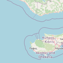
Map view of Yalias River

Use this park location map to pinpoint Yalias River in Cyprus, understand its exact geographic position, and read its mapped placement within the surrounding landscape more clearly.

Pigeon | © OpenStreetMap contributors
Park atlas

Compare regional Mediterranean landscapes, river valleys, and connected habitats

Explore Other Parks Near Potamos Gialias and Surrounding Protected Areas

Browse nearby national parks and protected areas sharing similar Mediterranean river valley ecosystems and regional terrain traits. Comparing adjacent reserves helps place local conservation sites within a wider geographical and ecological context.
Nature reserveCyprus
About 1.4 km away#1 closest

Northeast

Alykos Potamos - Agios Sozomenos: Inland Nature Reserve and Protected Landscape in Cyprus

A diverse Mediterranean mosaic of riparian gallery and halophytic scrub habitats.

Located in central Cyprus, this nature reserve protects a sensitive inland landscape where stream corridors meet Mediterranean salt meadows and dryland shrub formations. The site is a critical refuge for numerous bird species and the rare orchid Ophrys kotschyi, reflecting a high density of protected habitats within a compact, geographically rich area.

Area
3.728 km²
Established
2002
Relief
Lowland
Climate
Mediterranean
Nature reserveCyprus
About 5.4 km away#2 closest

Southwest

Dasos Machaira Nature Reserve: Geographic Overview and Protected Landscape Mapping

A diverse Natura 2000 protected area in central Cyprus

Spanning an inland expanse in central Cyprus, Dasos Machaira serves as a prime example of Mediterranean ecological diversity. The nature reserve encompasses a varied terrain of river valleys, golden oak woodland, and steep rocky slopes, documented through its status as both a Site of Community Importance and a Special Protection Area. The site remains a critical hub for endemic plant life and migratory bird populations, showcasing a dense convergence of distinct habitat types.

Area
44.28 km²
Established
2002
Relief
Upland
Climate
Mediterranean
Nature reserveCyprus
About 8.8 km away#3 closest

Southwest

Periochi Tzionia: Protected Landscape Mapping and Geographic Context in Cyprus

A Natura 2000 designated nature reserve in the Cyprus interior.

Periochi Tzionia serves as a significant terrestrial protected area, defined by its function within the Mediterranean ecoregion. This nature reserve provides essential structural support for diverse bird communities, serving as a pillar of regional conservation efforts in Cyprus through its role in the EU Birds Directive framework.

Area
68.428 km²
Established
2008
Climate
Mediterranean
Scope
Terrestrial
Protected areaCyprus
About 11 km away#4 closest

Southeast

Potamos Panagias Stazousas Protected Area: Geography and Landscape of Central Cyprus

Riverine corridors and Mediterranean avian habitats

Potamos Panagias Stazousas represents a core protected area in inland Cyprus, recognized primarily for its rich birdlife and distinct river-centered geography. This site showcases a diverse Mediterranean mosaic of scrubland, farmland, and woodland, providing critical ecological connectivity within the eastern Mediterranean basin.

Area
17.45 km²
Established
2007
Climate
Mediterranean
Scope
Terrestrial
Nature reserveCyprus
About 11 km away#5 closest

Southeast

Dasos Stavrovouniou Nature Reserve: Central Cyprus Protected Geography and Map

Mediterranean pine woodlands and avian habitat mosaic

Spanning 1,930 hectares of central Cyprus, Dasos Stavrovouniou features a varied topography of stony ridges, ravines, and siliceous cliffs. This protected area supports a dense habitat mosaic, including phrygana shrublands and evergreen forests that provide essential shelter for endemic Cyprus species and migratory raptors within the Natura 2000 framework.

Area
19.281 km²
Established
2002
Relief
Upland
Climate
Mediterranean
Nature reserveCyprus
About 12 km away#6 closest

East

Periochi Lympion - Agias Annas: Inland Protected Landscapes and Nature Reserve Atlas

Mediterranean shrubland and bird conservation zones in central Cyprus

Periochi Lympion - Agias Annas preserves essential thermo-Mediterranean shrubland and Sarcopoterium-dominated phrygana formations within the Cyprus interior. This protected landscape sustains a mosaic of pseudo-steppe grasslands and diverse bird populations, providing a focused view of inland habitat conservation within the eastern Mediterranean ecoregion.

Area
5.167 km²
Established
2002
Relief
Lowland
Scope
Terrestrial
Nature reserveCyprus
About 13 km away#7 closest

South

Periochi Lefkaron: Exploring the Protected Landscapes and Nature Reserves of Cyprus

Mediterranean shrublands, forest groves, and protected habitats

Periochi Lefkaron is a significant protected area in Cyprus, encompassing a diverse mosaic of phrygana, carob groves, and rare oriental plane woodlands. This record offers a structured look at the terrain and habitat types preserved within the site, providing essential geographic context for one of the island's most distinctive Mediterranean ecological corridors.

Area
1.32 km²
Established
2002
Climate
Mediterranean
Scope
Terrestrial
Protected areaCyprus
About 15 km away#8 closest

West

Koilada Potamou Maroullenas Protected Area: Geography and Landscape of a Mediterranean Valley

Exploring natural terrain and riverine habitats in Cyprus

Koilada Potamou Maroullenas is a protected area in Cyprus characterized by its Mediterranean river valley, intermittent watercourses, and rich mosaic of vegetation. The landscape spans from riparian galleries to phrygana and pine forests, making it a vital unit for regional biodiversity and habitat preservation within the island nation.

Area
0.722 km²
Established
2002
Relief
Mixed relief
Climate
Mediterranean

Common questions about visiting, size, designation, and location context for Yalias River

Yalias River FAQs for park facts, access, geography, and protected area context

Find quick answers about Yalias River, including protected-area facts, park geography, trail and visitor context, and how the park fits into its surrounding country and regional landscape.
MoriAtlas Explorer

Continue Your Protected Areas Search Across the Global Atlas

Deepen your exploration by continuing the structured search for national parks and protected areas worldwide. Utilize the comprehensive filtering capabilities to compare different conservation landscapes and refine your understanding of global park geography. Discover more about the distribution and characteristics of protected natural areas.

Global natural geography