
Mori Atlas logo
Protected landscapePřírodní park Čeřínek

Tracing the forested ridges, granite outcrops, and upland terrain within the Jihlava District

Přírodní park Čeřínek: A Detailed Map and Geographic Overview of the Protected Landscape

Přírodní park Čeřínek encompasses 23 square kilometers of continuous coniferous forest within the Křemešnická vrchovina highlands of the Czech Republic. This protected landscape is defined by its rolling ridges, granite rock formations at sites like Čertův hrádek, and the ecologically distinct Hojkovské rašeliniště peatland. The geography provides a compact yet varied upland setting, characterized by the 762 meter Čeřínek summit and a network of sheltered valleys.

nature parkconiferous forestspruce forestCzech-Moravian HighlandsKřemešnická vrchovinaupland landscape
An artistic, flat-style illustration showing a stylized mountain range with a central waterfall feeding into a winding river, all surrounded by green evergreen trees.

Přírodní park Čeřínek

Protected landscape

Park overview

Structured park overview, official facts, and landscape profile for Přírodní park Čeřínek

Přírodní park Čeřínek park facts, protected area profile, and essential visitor context

Review the core facts for Přírodní park Čeřínek, including designation, size, terrain, visitor scale, habitats, and operating context in one park-focused overview.

About Přírodní park Čeřínek

Přírodní park Čeřínek lies in the heart of the Czech-Moravian Highlands, in the Jihlava District of the Vysočina Region, just east of the village of Nový Rychnov. Officially designated as a nature park (přírodní park) on 21 December 1985, it spans about 23 square kilometers of gently rolling, heavily forested terrain that embodies the quieter, more forested side of the Czech uplands.

The park is anchored by the hill Čeřínek, whose summit at 762 meters gives the protected area its name. Around it rises a constellation of secondary peaks including Huťský vrch, Přední skála, and Čertův Hrádek, all in the 700-meter range, which together shape a compact highland enclosure of ridges, valleys, and rocky outcrops. A ring of small villages, including Nový Rychnov, Milíčov, Hojkov, Mirošov, Dvorce, Kostelec, Dolní Cerekev, and Rohozná, marks the boundary of the protected area and reflects the traditional, rural character of this part of Vysočina.

Ecologically, Přírodní park Čeřínek is dominated by deep, mostly coniferous forest, with spruce as a particularly characteristic species, as suggested by the park's own depiction of spruce stands. Within the broader forest matrix, however, lie several clearly defined protected natural monuments that highlight the area's geological and ecological diversity. These include the rock formations Čertův hrádek, Přední skála, and Na Skalce, the slope site Pod Mešnicí, and the nationally important Hojkovské rašeliniště, a peatland near the village of Hojkov that adds a distinctive wetland element to an otherwise predominantly forested landscape.

For visitors, the park offers a well-developed network of outdoor infrastructure. The Čeřínek nature trail provides thematic interpretation of the surrounding landscape, while red, blue, yellow, and green hiking markers connect the area to the wider Vysočina trail system. Cycling route 5090 passes through the park, and a ski area operates on the slopes of Čeřínek itself, making the park a year-round destination for hiking, cycling, and winter sports amid typically Czech highland scenery.

Quick facts and research context for Přírodní park Čeřínek

Přírodní park Čeřínek is a nature park in the Jihlava District of the Czech Republic, in the Vysočina Region. It was designated as a protected area on 21 December 1985 and covers about 23 square kilometers of primarily forested upland terrain.

The park is named after the hill Čeřínek, which at 762 meters is its highest point, and includes other notable summits such as Huťský vrch, Přední skála, Čertův Hrádek, and Na vršku. Several smaller protected sites are nested within its boundaries, including the nationally protected Hojkovské rašeliniště peat bog.

Protection and recognition

Review documented terrestrial conservation scope and recognition history.

Přírodní park Čeřínek Protection Status and Official Designation Record

Přírodní park Čeřínek holds a documented terrestrial protection status covering local conservation management scope. Records track official designation details without international recognition sources.

Protection details

Protection scope
Terrestrial
Transboundary protection
No
Park context

Deeper park guide and search-rich context for Přírodní park Čeřínek

Přírodní park Čeřínek history, landscape, wildlife, and travel context

Explore Přírodní park Čeřínek through its history, landscape character, ecosystems, wildlife, conservation priorities, cultural context, and seasonal travel timing in a structured park guide built for atlas discovery and search intent.

Why Přírodní park Čeřínek stands out

Přírodní park Čeřínek is best known for its extensive tracts of mostly coniferous forest draped across the rolling ridges of the Křemešnická vrchovina. The landscape combines forested hills, granite rock formations, and small peatland pockets, giving the area a quietly distinctive character within the Czech-Moravian Highlands. The park is also known for the cluster of small protected natural monuments within its boundaries, including rocky outcrops such as Čertův hrádek and Přední skála, and the nationally protected Hojkovské rašeliniště peat bog near Hojkov. Together, these features make the park a compact but ecologically varied showcase of upland central Bohemian nature.
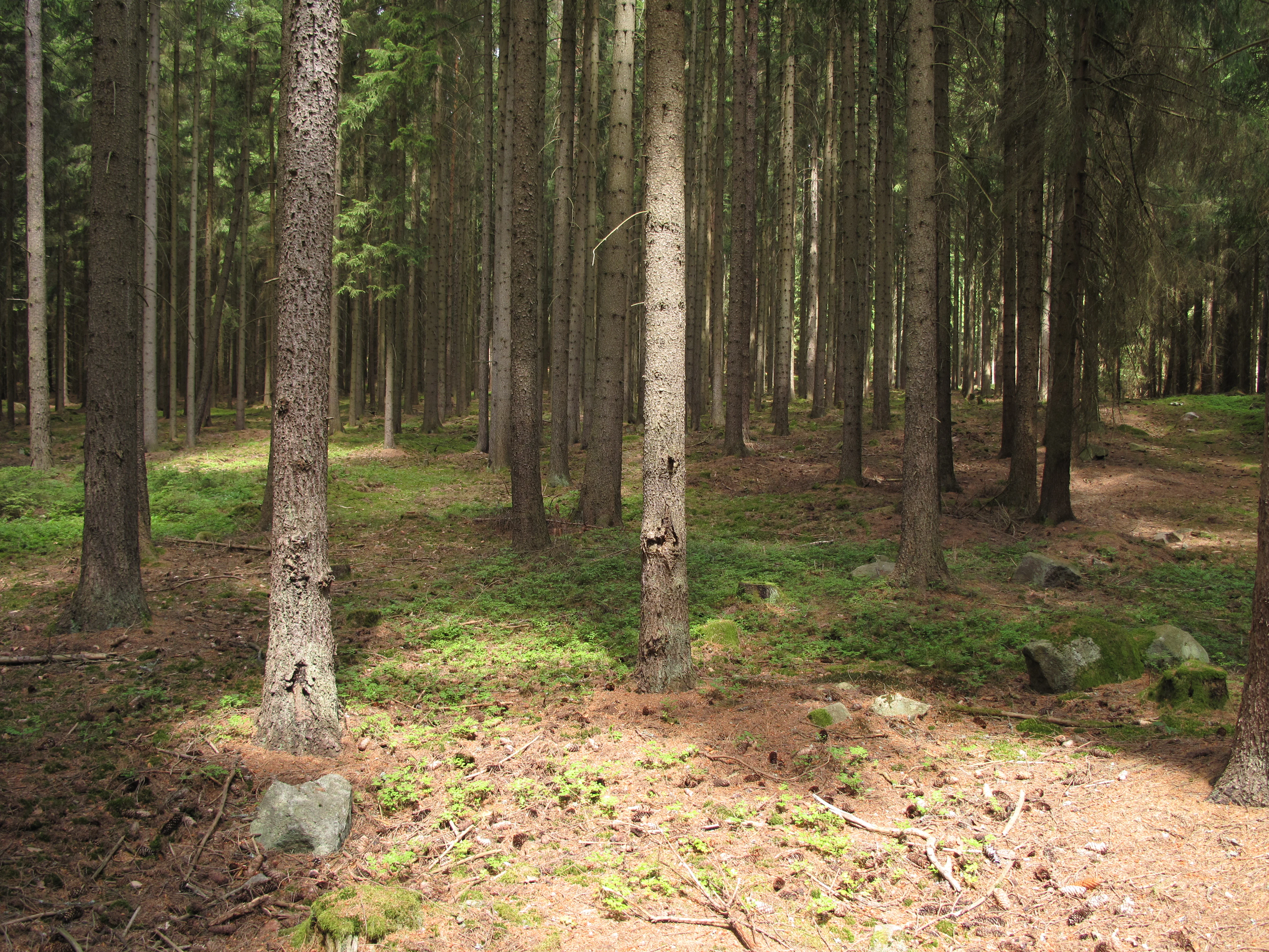
A dense coniferous forest with tall, straight tree trunks and a forest floor covered in moss and pine needles, with patches of sunlight filtering through the canopy.
A view of the coniferous forest within Přírodní park Čeřínek.

Přírodní park Čeřínek history and protected-area timeline

Přírodní park Čeřínek was officially declared as a protected area on 21 December 1985, in what was then Czechoslovakia. The designation as a přírodní park, a regional category of protected landscape in the Czech system, reflects an intent to preserve the forested upland character of the Křemešnická vrchovina around the prominent hill Čeřínek rather than to establish a strictly managed core zone.

Since its establishment in 1985, the park has continued to function as a landscape-level protection area, encompassing both continuous forest and a number of smaller, separately designated natural monuments. These nested sites, including Čertův hrádek, Přední skála, Na Skalce, and Pod Mešnicí, together with the nationally protected Hojkovské rašeliniště, indicate that the park was created within a landscape already recognized for its smaller-scale ecological and geological features, and that the 1985 designation formally consolidated their surroundings into a single protected framework.

Přírodní park Čeřínek landscape and geographic character

The landscape of Přírodní park Čeřínek is shaped by the Křemešnická vrchovina, a highland area of the broader Czech-Moravian Highlands. The terrain consists of gently rolling ridges and valleys, with elevations clustering around the 700-meter mark and rising to the park's high point of 762 meters on Čeřínek itself. Other prominent summits, including Huťský vrch at 710 meters, Přední skála at 714 meters, and Čertův Hrádek at 715 meters, give the park a compact, encircling feel rather than a single dramatic skyline.

Scattered through this forested upland are exposed rock formations and small rock outcrops that give the otherwise soft contours of the hills a distinctive local character. Sites such as Čertův hrádek, Přední skála, and Na Skalce highlight these geological features, while the surrounding slopes are blanketed in deep coniferous forest, particularly spruce. In contrast to the wooded ridges, the Hojkovské rašeliniště near Hojkov introduces a flatter, wetter element to the landscape, anchoring a small but ecologically significant peatland within an otherwise dry, forested setting.
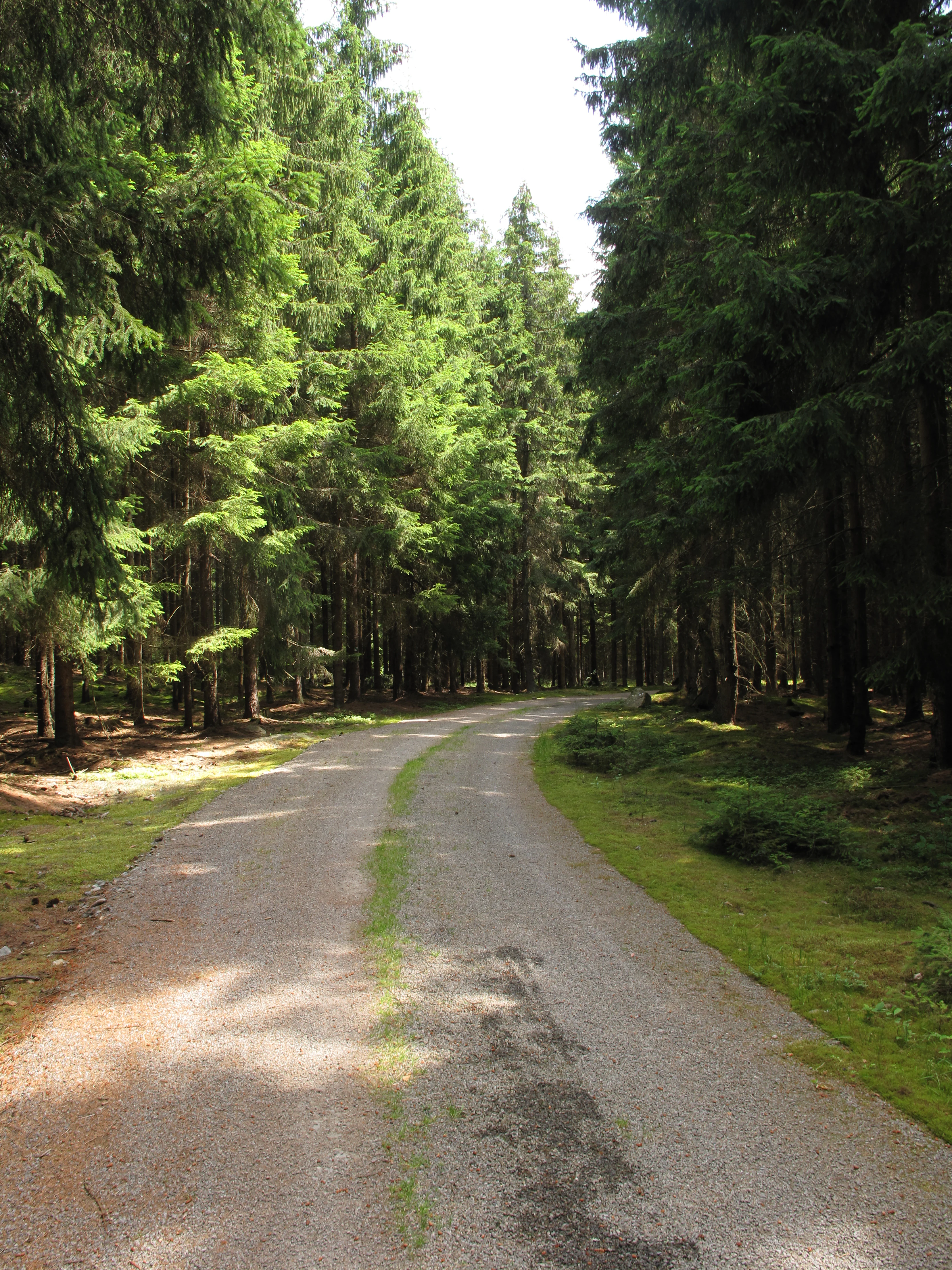
A narrow gravel forest road curves gently between tall, dense conifer trees.
A forest path winding through the coniferous woods of Přírodní park Čeřínek.

Přírodní park Čeřínek ecosystems, habitats, and plant life

Ecologically, Přírodní park Čeřínek is dominated by extensive coniferous forest, with spruce stands forming a particularly characteristic and visually dominant element. The deep, mostly even-aged evergreen forests give the park a distinctly boreal-central European character and cover the majority of the protected area's roughly 23 square kilometers.

Embedded within this forested matrix is a deliberate mosaic of smaller protected natural monuments that diversify the ecological profile of the area. Rock outcrops at Čertův hrádek, Přední skála, and Na Skalce support specialized flora adapted to thin, rocky soils and exposed microclimates, while the site Pod Mešnicí protects additional habitat features on the slopes. The most ecologically distinctive component, however, is Hojkovské rašeliniště, a nationally protected peatland near Hojkov, which introduces a completely different habitat type based on waterlogged, acidic, nutrient-poor conditions and supports bog communities that are rare in this part of the Czech uplands.

Přírodní park Čeřínek wildlife and species highlights

The wildlife profile of Přírodní park Čeřínek is shaped by the combination of large coniferous forest blocks and the contrasting open wetland of Hojkovské rašeliniště. The extensive spruce and mixed conifer stands provide habitat for forest-dwelling species typical of the Czech-Moravian Highlands, while the rocky outcrops and peatland create localized niches for specialized flora and fauna.

Although the available source material does not enumerate specific species in detail, the presence of nationally protected peatland and multiple smaller natural monuments indicates that the park supports habitat conditions significant enough to merit recognition at both regional and national levels. The mixture of mature forest, exposed rock, slope woodland, and bog gives the area a layered wildlife character that includes both widespread forest species and more localized communities tied to unusual substrates.

Přírodní park Čeřínek conservation status and protection priorities

Přírodní park Čeřínek serves as a regional conservation framework in the Czech system of protected areas, safeguarding about 23 square kilometers of forested highland landscape in the Jihlava District. Its 1985 designation recognized the ecological and landscape value of the Křemešnická vrchovina around the peak of Čeřínek, ensuring that forestry, recreation, and local land use would be balanced against the protection of the area's natural character.

The conservation importance of the park is reinforced by the presence of multiple nested protected sites, including four natural monuments and the nationally designated Hojkovské rašeliniště peat bog. This nested structure means that Přírodní park Čeřínek does not function merely as a generic landscape protection zone; it also contains ecologically critical small-scale habitats, such as rock outcrops and peatland, that contribute meaningfully to biodiversity conservation in the broader Vysočina Region.

Přírodní park Čeřínek cultural meaning and human context

The park sits within a strongly traditional rural landscape of the Vysočina Region, framed by a ring of small villages including Nový Rychnov, Milíčov, Hojkov, Mirošov, Dvorce, Kostelec, Dolní Cerekev, and Rohozná. These settlements have long shaped patterns of land use around the forested hills, and the park's designation reflects a long-standing relationship between local communities and the surrounding woodlands.

The presence of a network of marked hiking trails, a cycling route, a dedicated nature trail (Naučná stezka Čeřínek), and a ski area on Čeřínek itself reflects how the local population has integrated the protected landscape into everyday outdoor recreation. The park is thus not only an ecological asset but also a central feature in the regional identity and outdoor culture of the Czech-Moravian Highlands.

Top sights and standout views in Přírodní park Čeřínek

Přírodní park Čeřínek is notable for combining a continuous expanse of spruce-dominated highland forest with a surprising diversity of smaller protected habitats. Within its roughly 23 square kilometers, visitors encounter rocky outcrops such as Čertův hrádek and Přední skála, slope woodland at Pod Mešnicí, and the nationally protected peatland of Hojkovské rašeliniště.

The park's accessibility is another highlight in its own right. Thanks to the Čeřínek nature trail, a network of color-marked hiking routes, cycling route 5090, and an on-site ski area, Přírodní park Čeřínek offers a year-round outdoor experience set against the gentle, forested ridges of the Czech-Moravian Highlands.

Best time to visit Přírodní park Čeřínek

Přírodní park Čeřínek rewards visits throughout the year, with the character of the landscape shifting noticeably with each season. In late spring and summer, the dense spruce forests and rocky outcrops are best explored on the marked hiking trails and the Čeřínek nature trail, when the network of cycling and walking routes is fully accessible.

In autumn, the mixed elements of the forest display richer seasonal color, while winter transforms the park into a quieter, snow-covered landscape, particularly around the slopes of Čeřínek itself, where the local ski area operates. There is no single fixed high season here; rather, the park offers different appeals depending on whether a visitor is drawn to summer greenery, autumn forest tones, or winter snow-based recreation in the Czech uplands.

Monthly climate preview

Long-term representative point measurements tracking temperature and precipitation rhythm

Přírodní park Čeřínek Climate Normals and Annual Weather by Month

Historical NASA records for Přírodní park Čeřínek outline a measured annual progression of average temperatures from winter lows to summer peaks alongside monthly precipitation rates. Accessing the complete climate profile provides full monthly statistical breakdowns across all twelve recorded cycles.
Annual mean7 °C
-4 °C18 °C
Jan-4°
Feb-2°
Mar
Apr
May12°
Jun16°
Jul18°
Aug18°
Sep13°
Oct
Nov
Dec-2°
Warmest month
July

18.1 °C

Coolest month
January

-3.6 °C

Wettest month
July

2.9 mm/day

Driest month
February

1.3 mm/day

Park location guide

Geography guide, regional context, and park location map for Přírodní park Čeřínek

Přírodní park Čeřínek park geography, regions, and map view in Czechia

Understand where Přírodní park Čeřínek sits in Czechia through a broader geographic reading of the surrounding landscape, nearby location context, and its mapped position within the national park landscape.

How Přírodní park Čeřínek fits into Czechia

Czech Republic is a landlocked Central European country with a population of approximately 10.9 million people. The nation was established as an independent state on January 1, 1993, following the dissolution of Czechoslovakia. Its capital and largest city is Prague, with other major urban centers including Brno, Ostrava, Plzeň, and Liberec.

Wider geography shaping Přírodní park Čeřínek in Czechia

The Czech Republic is a landlocked country in Central Europe. It is bordered by Germany to the west, Austria to the south, Poland to the northeast, and Slovakia to the southeast. The landscape is predominantly hilly, with the territory covering 78,871 square kilometers.

Map view of Přírodní park Čeřínek

Use this park location map to pinpoint Přírodní park Čeřínek in Czechia, understand its exact geographic position, and read its mapped placement within the surrounding landscape more clearly.

Pigeon | © OpenStreetMap contributors

Location context for Přírodní park Čeřínek

Jihlava District

Visual reference for highland forests, granite rock outcrops, and peatland habitats

Přírodní park Čeřínek Landscape Photos and Protected Area Scenery

Visual documentation captures the forested ridges, granite rock formations, and protected peatlands defining the upland terrain of Přírodní park Čeřínek. Photographic records provide clear environmental context for understanding the varied habitats and topography of the Czech-Moravian Highlands.

A dense coniferous forest with tall, straight tree trunks and a forest floor covered in moss and pine needles, with patches of sunlight filtering through the canopy.

A narrow gravel trail leading into a tall, dense forest of coniferous trees with a mossy ground layer.

A narrow gravel forest road curves gently between tall, dense conifer trees.

Park atlas

Compare surrounding regional park geography and connected highland landscapes

Parks Near Přírodní Park Čeřínek and Related Upland Protected Areas

Browse other protected areas near Přírodní park Čeřínek to compare similar forested ridges and highland terrain across the region. Extending the geographic review reveals broader regional park patterns and adjacent conservation zones within the uplands.
Nature reserveCzechia
About 8 km away#1 closest

Northwest

Prameniště Jankovského potoka: Protected Wetland Landscapes in the Czech Vysočina Region

An atlas exploration of highland spring-fed meadow ecosystems and conservation corridors.

Prameniště Jankovského potoka acts as a cornerstone for wetland conservation in the Vysočina Region. The site features a mosaic of nutrient-poor peat meadows and spring-fed stream corridors, providing stable habitats for endangered freshwater pearl mussels and unique highland flora. This protected area offers a clear look at the intersection of traditional meadow management and hydrological restoration in the Czech landscape.

Area
0.658 km²
Established
2018
IUCN
IV
Relief
Upland
A soft watercolor illustration of a marshy landscape featuring light green grassy plains, patches of water, and a hazy treeline in the distance.
Nature reserveKraj Vysočina
About 16 km away#2 closest

Southwest

Rašeliniště Kaliště Nature Reserve: Geographic Overview and Mapped Protected Boundaries

Highland wetland habitat in the Kraj Vysočina region

Rašeliniště Kaliště is a compact but ecologically significant nature reserve characterized by its rare meadow-type peat bog habitat. Located in the Czech-Moravian Highlands, it functions as a primary site for protected moss species and wetland preservation, offering valuable geographic insight into the hydrologic features of the Vysočina landscape.

Area
0.119 km²
Established
1982
IUCN
IV
Relief
Lowland
Natural monumentKraj Vysočina
About 22 km away#3 closest

Southeast

Urbánkův palouk Natural Monument: Protected Highland Landscape and Meadow Geography

Preserved peat meadow terrain in the Czech Republic.

Urbánkův palouk serves as a critical natural monument in Kraj Vysočina, protecting a rare fragment of wet and peat-influenced meadow habitat. Positioned on a highland plateau at 622 meters, this site functions as an ecologically dense refuge for threatened plant species within the traditional Czech-Moravian Highland landscape.

Area
0.01 km²
Established
1990
IUCN
IV
Relief
Lowland
Watercolor illustration of a peaceful landscape featuring soft-colored hills, green trees, and an open foreground on a white background.
Natural monumentKraj Vysočina
About 23 km away#4 closest

Southeast

Na Kopaninách Natural Monument and Protected Meadow Geography in the Vysočina Region

A vital habitat for rare Bohemian-Moravian grassland flora.

Situated at an elevation of 550 to 570 meters, Na Kopaninách represents a critical fragment of traditional rural landscape. The area consists of a small mosaic of hay meadows and communal pasture, playing a central role in national rescue programs for rare gentian populations. Its north-facing terrain and nutrient-poor soils support a specialized botanical community that highlights the importance of small-scale habitat protection.

Area
0.01 km²
Established
1986
IUCN
IV
Relief
Lowland
Natural monumentJihočeský kraj
About 34 km away#5 closest

Southwest

Vosecký rybník Natural Monument: Protected Wetland Geography in Jihočeský kraj

Rare drawdown-bottom flora and aquatic ecosystems

Located in the Javořická vrchovina highlands, Vosecký rybník is a protected natural monument known for its specialized pond-bottom vegetation. The site serves as a vital ecological corridor for threatened species within the broader mosaic of historic Bohemian fishpond landscapes.

Area
0.071 km²
Established
2022
IUCN
III
Relief
Upland
Watercolor painting of a rolling countryside scene featuring green hills, forest edges, and muted pastel tones on a white background.
Protected landscapeVysočina Region
About 34 km away#6 closest

East

Přírodní park Bohdalovsko: Protected Landscape and Wetland Geography in the Vysočina Region

Highland terrain, fishpond mosaics, and protected natural corridors.

Located in the Czech Republic, Přírodní park Bohdalovsko serves as a primary example of a cultural highland landscape. The area features a remarkable concentration of ponds and peatland pockets that anchor local biodiversity, including rare aquatic species and amphibian strongholds. Its geography is characterized by rolling uplands and varied forest-field mosaics that remain integral to the regional conservation framework of the Bohemian-Moravian Highlands.

Area
60.8 km²
Established
2001
Relief
Upland
Climate
Temperate
A soft watercolor painting of a serene landscape featuring a calm lake surrounded by trees and gentle rolling hills in the background.
Natural monumentKraj Vysočina
About 39 km away#7 closest

Northeast

Rozštípená skála Natural Monument: Geological Mapping of the Vysočina Gneiss Outcrops

Protected rocky terrain in the Bohemian-Moravian Highlands

Rozštípená skála features a striking gneiss cliff formation split by long weathered fissures. Located in the Vysočina Region, this natural monument provides a focal point for understanding the geological patterns and river valley landscapes that define the mid-altitude terrain of the Czech Republic.

Area
0.008 km²
Established
1974
IUCN
III
Relief
Upland
Watercolor painting of a light-filled landscape featuring soft green trees and pale pinkish clouds against a white background.
Protected landscapeJihočeský kraj
About 39 km away#8 closest

Southwest

Přírodní park Česká Kanada: Protected Landscape and Bohemian Highland Geography

A diverse mosaic of boulder fields, peat bogs, and forest terrain.

Discover the rugged beauty of Přírodní park Česká Kanada, where geological history meets a rewilded border landscape. This protected area in Jihočeský kraj is defined by massive granite formations, dense beech forests, and an intricate network of wetlands and ponds, providing a significant sanctuary within the Bohemian-Moravian Highlands.

Area
283 km²
Established
1994
Relief
Upland
Climate
Temperate

Common questions about visiting, size, designation, and location context for Přírodní park Čeřínek

Přírodní park Čeřínek FAQs for park facts, access, geography, and protected area context

Find quick answers about Přírodní park Čeřínek, including protected-area facts, park geography, trail and visitor context, and how the park fits into its surrounding country and regional landscape.
MoriAtlas Explorer

Continue Your Protected Areas Search Across the Global Atlas

Deepen your exploration by continuing the structured search for national parks and protected areas worldwide. Utilize the comprehensive filtering capabilities to compare different conservation landscapes and refine your understanding of global park geography. Discover more about the distribution and characteristics of protected natural areas.

Global natural geography