

Mori Atlas logo
State or regional parkQuatsino Provincial Park

Discover the intricate geography of old-growth temperate rainforests, marine inlets, and sheltered estuaries.

Quatsino Provincial Park: Mapped Protected Landscapes and Coastal Geography in British Columbia

Quatsino Provincial Park represents a significant protected wilderness area on the northern coast of Vancouver Island, British Columbia. The terrain is defined by its deep coastal indentations, including the sheltered waters of Koprino Harbour and the diverse transition zones of the Koprino River estuary. These mapped landscapes support an array of habitats, from dense coniferous old-growth canopy to freshwater interior lakes, providing a vital study in temperate coastal ecology.

coastal forestold-growth forestmarine inletriver estuarykayakingsea kayak route

Quatsino Provincial Park

State or regional park

Park overview

Structured park overview, official facts, and landscape profile for Quatsino Provincial Park

Quatsino Provincial Park park facts, protected area profile, and essential visitor context

Review the core facts for Quatsino Provincial Park, including designation, size, terrain, visitor scale, habitats, and operating context in one park-focused overview.

About Quatsino Provincial Park

Quatsino Provincial Park sits on the rugged northern shore of Vancouver Island, where the deeply fjord-like waters of Quatsino Sound cut into forested mountains and hills. Although modest in size, the park captures many of the defining features of the island's north coast in a single protected unit: sheltered marine inlets, a river estuary, small interior lakes, and a continuous blanket of temperate rainforest.

The park was formally established under BC Parks in the mid-1990s, and its undeveloped character has been a central part of its identity ever since. There are no paved roads, no major campground infrastructure, and no visitor center; instead, the park is reached either by boat across Quatsino Sound or by rough, sometimes seasonally restricted logging roads. This relative inaccessibility has helped preserve the integrity of its habitats and contribute to the wild character that visitors experience today.

Ecologically, Quatsino Provincial Park stands out for the unusual combination of features it protects within a small area. Koprino Harbour provides a sheltered saltwater inlet that supports marine wildlife and quiet anchorage. The Koprino River estuary is recognized as important fish-rearing and waterfowl habitat, while scattered freshwater lakes across the interior add to habitat diversity. Around and above these features, the park still contains stands of old-growth forest, including some of the larger trees in the surrounding region. Together these qualities give the park a depth and ecological richness that would not be obvious from its compact size on a map.

For visitors, Quatsino is best experienced as a marine-access park. It lies along a sea-kayaking route favored by paddlers exploring Quatsino Sound, and backcountry campers and hikers use the park for short wilderness stays accessed primarily by water. Fishing and hunting are also supported under BC Parks management. The park serves less as a quick roadside stop and more as a destination for people who want to encounter a relatively undisturbed slice of northern Vancouver Island's coastal temperate landscape.

Quick facts and research context for Quatsino Provincial Park

Quatsino Provincial Park is a Class II-equivalent protected area under BC Parks, situated on Quatsino Sound on northern Vancouver Island, British Columbia. Established on July 13, 1995 and covering roughly 654 hectares, the park is administered by BC Parks and remains essentially undeveloped, with no major roads or infrastructure crossing its interior.

Its setting combines marine shoreline, forested lowlands, small lakes, the sheltered inlet of Koprino Harbour, and the estuary of the Koprino River. The park is most notable for old-growth coastal forest, concentrations of bald eagles, and populations of black bears, black-tailed deer, and cougars. Nearby access points include the communities of Port Hardy and Port Alice.

Protection and recognition

Examine the documented protection status and governance scope for this protected area.

Quatsino Provincial Park Protection Status and Conservation Recognition

Quatsino Provincial Park maintains a documented mixed protection status within regional conservation frameworks. Review official designation records and management scope details associated with the protected area.

Protection details

Protection scope
Mixed
Park context

Deeper park guide and search-rich context for Quatsino Provincial Park

Quatsino Provincial Park history, landscape, wildlife, and travel context

Explore Quatsino Provincial Park through its history, landscape character, ecosystems, wildlife, conservation priorities, cultural context, and seasonal travel timing in a structured park guide built for atlas discovery and search intent.

Why Quatsino Provincial Park stands out

Quatsino Provincial Park is best known for its old-growth coastal forest and for supporting one of the higher concentrations of bald eagles on northern Vancouver Island. The combination of mature forest, sheltered inlet habitat, and the Koprino River estuary creates conditions that are unusually rich for both nesting raptors and waterfowl. Beyond the eagle-rich forest canopy, the park is also recognized for healthy populations of black bears and coastal black-tailed deer, and for retaining a sense of remote, roadless coastal wilderness. Its position along a popular sea-kayak route reinforces its identity as a place where marine access and intact temperate rainforest overlap in a small, concentrated protected footprint.
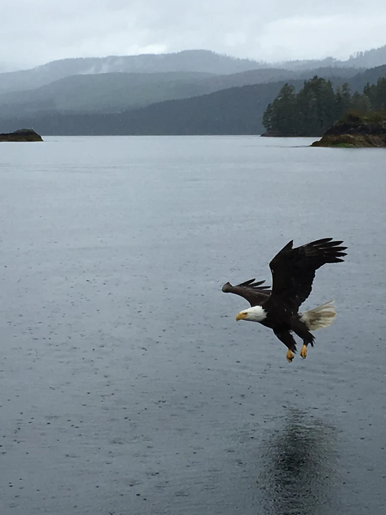
A bald eagle with its wings spread flying low over a body of water, with forested hills in the background under an overcast, rainy sky.
A bald eagle flying over the water in Quatsino Provincial Park during a rain shower.

Quatsino Provincial Park history and protected-area timeline

Quatsino Provincial Park was established on July 13, 1995, under the administration of BC Parks. Its creation reflected a wider conservation priority on northern Vancouver Island, where remaining tracts of old-growth coastal forest and intact estuarine systems had become increasingly rare in the face of long-established logging activity across the region.

From the outset, the park was designated as an undeveloped protected area, with no road network crossing its core and management focused on preserving natural processes rather than building visitor infrastructure. The surrounding landscape had already been shaped by industrial forestry, which actually makes the park's old-growth stands and undisturbed estuary more ecologically significant as remnant and refuge habitat.

Since its establishment, the park has remained in its undeveloped state, and its history in the decades since has been less about institutional change than about the gradual accumulation of recognition as a quiet but valuable stronghold for old-growth forest, estuarine habitat, and species such as bald eagles, black bears, and black-tailed deer on the northern coast of Vancouver Island.

Quatsino Provincial Park landscape and geographic character

The landscape of Quatsino Provincial Park is shaped by the meeting of land and sea along Quatsino Sound, on the northeastern side of Vancouver Island. The terrain combines steep forested slopes with sheltered coves and inlets, while the interior of the park includes flatter lowlands, small lakes, and the lower valley of the Koprino River where it reaches the coast.

Koprino Harbour is one of the defining landscape features, providing a calm, sheltered inlet tucked into the shoreline. The Koprino River estuary at the head of this system creates a transitional zone of tidal flats, riparian vegetation, and brackish habitat that contrasts with the dense coniferous forest covering much of the surrounding land. Several small lakes punctuate the forested interior of the park, adding open water within an otherwise continuous canopy.

Above and around these water features, the park's landscape is defined by old-growth temperate rainforest, with large trees forming a continuous canopy that softens the contours of the terrain. The combination of fjord-like coastline, estuary, lakes, and old-growth forest gives the park a layered coastal landscape that is rich in visual variety despite its modest size.

Quatsino Provincial Park ecosystems, habitats, and plant life

Ecologically, Quatsino Provincial Park reflects the classic elements of coastal temperate rainforest on the Pacific Northwest coast, compressed into a relatively small protected footprint. The park's habitats include old-growth coniferous forest, shoreline forest along Quatsino Sound, freshwater lakes, sheltered marine inlet, and a tidal river estuary.

The old-growth stands are particularly significant, representing some of the largest and most intact trees in the surrounding area. These mature forests provide structural complexity, including large trunks, fallen logs, and a multilayered canopy, that supports a wide range of forest-dependent species. The lakes and Koprino River add freshwater components to the habitat mosaic, while the estuary functions as a critical transition zone where nutrients from the forest and freshwater system meet the marine waters of Quatsino Sound.

This combination of habitats within a single protected unit gives the park an ecological density that exceeds what its modest area might suggest. Saltwater shoreline, estuarine mudflats, riparian forest, old-growth upland, and small lake basins together create overlapping and complementary habitat zones that sustain both resident and seasonal wildlife populations along the northern Vancouver Island coast.

Quatsino Provincial Park wildlife and species highlights

Wildlife is one of the strongest identity markers of Quatsino Provincial Park, and the park is particularly noted for a high concentration of bald eagles that nest and feed within its boundaries. The combination of mature forest for nesting and the fish-rich waters of Quatsino Sound and the Koprino River estuary supports eagles in unusually high densities compared with much of the surrounding region.

Black bears are described as very common in the park, taking advantage of the productive coastal forest, salmon-bearing streams, and berry-rich understory typical of northern Vancouver Island. Coastal black-tailed deer are also widespread throughout the forested landscape, browsing along shorelines and in clearings. Cougars are present as well, reflecting the intact predator communities supported by the park's undeveloped condition.

The Koprino River estuary adds a strong waterfowl and fish dimension to the park's wildlife profile, functioning as critical rearing habitat for fish and as feeding habitat for ducks and other waterbirds. Together, these species groups give Quatsino Provincial Park a recognizable wildlife identity centered on bald eagles, black bears, and the broader coastal fauna of the north island.

Quatsino Provincial Park conservation status and protection priorities

Quatsino Provincial Park plays an important conservation role on northern Vancouver Island by protecting a compact but ecologically rich area within a region that has otherwise been heavily influenced by logging. Its old-growth forest stands, sheltered inlet, and the Koprino River estuary together represent habitats that have become increasingly rare in the surrounding landscape.

The park's estuary is specifically noted for its value as critical fish-rearing and waterfowl habitat, linking freshwater and marine systems in a way that supports multiple species at once. The mature forest canopy in turn provides nesting sites for a high concentration of bald eagles, while the broader forest supports predators such as black bears and cougars. Protecting this combination within a single undeveloped unit gives the park a conservation significance that is disproportionate to its size.

By remaining roadless and undeveloped, the park also serves as a refuge from the disturbance and habitat fragmentation that dominate adjacent lands. In this sense, Quatsino Provincial Park functions less as a standalone wilderness and more as a key node in the broader network of remaining intact coastal habitat on the north coast of Vancouver Island.

Quatsino Provincial Park cultural meaning and human context

Quatsino Provincial Park lies within a region of Vancouver Island that carries a long history of coastal Indigenous presence and a more recent history of resource-based settlement. The broader area around Quatsino Sound has been home to coastal First Nations communities for thousands of years, and the waterways, estuaries, and forests of the region continue to hold cultural significance beyond their ecological value.

More recently, the surrounding landscape has been shaped by forestry, with logging roads providing some of the only land-based access to the park and the nearby communities of Port Hardy and Port Alice developing around maritime and resource industries. This mix of wilderness, working forest, and small coastal communities defines the human context in which the park exists, framing it as a quiet protected refuge within a working coastal region rather than a fully isolated wilderness.

Top sights and standout views in Quatsino Provincial Park

Quatsino Provincial Park's standout features are its old-growth forest stands, its high concentration of bald eagles, and the combination of Koprino Harbour and the Koprino River estuary as a single protected inlet-and-estuary system. Within a compact footprint, the park brings together old-growth temperate rainforest, sheltered saltwater, freshwater lakes, and a tidal estuary, giving it a layered coastal wilderness identity.

Equally notable is the park's undeveloped character. Without road access into its core and with management centered on preservation rather than visitor infrastructure, Quatsino retains a sense of routeless coastal forest that is increasingly uncommon on Vancouver Island. This combination of ecological richness and remoteness is what makes the park distinctive among BC Parks along the north coast.

Best time to visit Quatsino Provincial Park

Quatsino Provincial Park is best experienced in the warmer and drier months of late spring through early fall, when weather on Quatsino Sound is more likely to be calm enough for marine access by kayak or small boat, and when backcountry camping conditions are at their most comfortable. This window also coincides with the period when estuarine and forest wildlife are easiest to observe, including active fish-rearing in the Koprino River estuary and visible eagle activity around the shoreline.

In shoulder seasons, visitors should expect cooler temperatures, more rainfall, and rougher conditions on the sound, which can complicate boat and kayak access. Winter visits are possible but generally less inviting for casual recreation, though they may appeal to those seeking solitude and a quieter encounter with the park's coastal temperate landscape.
Monthly climate preview

Long-term representative temperature and monthly precipitation averages for Quatsino Provincial Park

Quatsino Provincial Park Climate Normals and Annual Weather Patterns

Quatsino Provincial Park exhibits a measured annual temperature range from negative averages to over twenty degrees Celsius alongside distinct monthly precipitation variations recorded at a representative coordinate. Examining the complete twelve-month climatology dataset reveals detailed long-term averages for sustained temperature shifts and precipitation totals.
Annual mean9 °C
5 °C14 °C
Jan
Feb
Mar
Apr
May10°
Jun12°
Jul14°
Aug14°
Sep13°
Oct10°
Nov
Dec
Warmest month
August

14.4 °C

Coolest month
February

5.5 °C

Wettest month
November

9.7 mm/day

Driest month
July

2.2 mm/day

Park location guide

Geography guide, regional context, and park location map for Quatsino Provincial Park

Quatsino Provincial Park park geography, regions, and map view in Canada

Understand where Quatsino Provincial Park sits in Canada through a broader geographic reading of the surrounding landscape, nearby location context, and its mapped position within the national park landscape.

How Quatsino Provincial Park fits into Canada

Canada is a federal parliamentary constitutional monarchy spanning North America from the Atlantic to the Pacific and Arctic Oceans. With a population of over 41 million, it is officially bilingual in English and French at the federal level. The country gained independence from the United Kingdom through a gradual process culminating in 1982.

Wider geography shaping Quatsino Provincial Park in Canada

Canada occupies the northern portion of North America, sharing its longest international border with the United States. The country extends from the Atlantic Ocean to the Pacific Ocean and northward into the Arctic Ocean, giving it the longest coastline of any nation.

Map view of Quatsino Provincial Park

Use this park location map to pinpoint Quatsino Provincial Park in Canada, understand its exact geographic position, and read its mapped placement within the surrounding landscape more clearly.

Pigeon | © OpenStreetMap contributors

Location context for Quatsino Provincial Park

British Columbia

Visualizing old growth rainforest habitats and coastal marine inlets on Vancouver Island

Quatsino Provincial Park Photos and Protected Landscape Scenery

Examinations of Quatsino Provincial Park reveal rugged coastal terrain, dense old growth forest canopies, and sheltered marine inlets. Photographic collections provide direct visual access to remote protected habitats, illustrating shoreline ecosystems and wetland environments across northern Vancouver Island.

A bald eagle with its wings spread flying low over a body of water, with forested hills in the background under an overcast, rainy sky.

Park atlas

Compare regional geography, temperate rainforests, and surrounding coastal wilderness zones

Explore Other Parks Near Quatsino Provincial Park and Protected Landscapes

Continue geographic comparison by discovering other protected areas and reserves located across northern Vancouver Island. Examining adjacent regional terrain reveals wider patterns in coastal temperate ecosystems and marine wilderness preservation.
State or regional parkBritish Columbia
About 31 km away#1 closest

West

Raft Cove Provincial Park: Coastal Wilderness and Protected Landscapes in British Columbia

Rugged shorelines and temperate rainforest terrain

Raft Cove Provincial Park protects a wild segment of Vancouver Island's northwestern coast. The region features a crescent-shaped sandy beach, significant river estuaries, and dense western hemlock forests. This protected area offers insight into the isolated coastal geography and the raw Pacific marine influences that shape the local wilderness terrain.

Area
7.87 km²
Established
1990
IUCN
II
Relief
Lowland
Protected areaBritish Columbia
About 146 km away#2 closest

East

Forward Harbour/Yexeweyem Conservancy Protected Area Geography and Coastal Atlas

Coastal wilderness protected landscape on Vancouver Island.

Forward Harbour/Yexeweyem Conservancy preserves a distinct segment of British Columbia coastline. Featuring the Thynne Peninsula and sheltered sections of Bassborough Bay, this remote protected area emphasizes the preservation of marine inlets and salmon habitats within a traditional Indigenous landscape.

Area
3.06 km²
Established
2007
Access
Remote access
Scope
Terrestrial
Protected areaBritish Columbia
About 148 km away#3 closest

Southeast

Kiišḥniqʷus Conservancy: Coastal Wilderness and River Valley Geography in British Columbia

Protected coastal inlet and temperate rainforest terrain

Kiišḥniqʷus Conservancy protects a significant expanse of land between Sydney Inlet and Shelter Inlet on the outer coast of Vancouver Island. This area focuses on the Sydney River valley and the associated estuarine environments, forming a vital part of the regional wilderness corridor. The geography showcases the intersection of deep coastal fjords, dense coniferous forest, and historic cultural sites, providing an essential look at the natural and indigenous history of the region.

Area
110.12 km²
Established
2024
Scope
Terrestrial
Water
Major water bodies
Protected areaBritish Columbia
About 150 km away#4 closest

North

Hakai Lúxvbálís Conservancy: Protected Coastal Landscapes and Geography in British Columbia

Coastal wilderness, island terrain, and marine foreshore habitats

Spanning over 51,000 hectares of upland, Hakai Lúxvbálís Conservancy is defined by its connection between forested island ridges and the Pacific marine environment. This protected area on the British Columbia Central Coast offers a deep look into temperate rainforest geography and indigenous-led conservation frameworks that prioritize ecosystem integrity across island and sea.

Area
1,229.98 km²
Established
2008
IUCN
II
Relief
Lowland
Protected areaBritish Columbia
About 157 km away#5 closest

Southeast

Kʷuḥaa Conservancy: A Coastal Protected Area on Western Vancouver Island

Temperate rainforest, marine inlets, and cultural geography.

Kʷuḥaa Conservancy covers a rugged, forested stretch of the British Columbia coastline, focusing on the preservation of the Stewardson Inlet head. The area integrates coastal slopes with sheltered marine environments, providing a crucial addition to the regional network of protected lands. Explore the site's unique topographical features and its cultural significance within the Nuu-chah-nulth territory near Tofino.

Area
19.16 km²
Established
2024
Relief
Lowland
Climate
Temperate
Protected areaBritish Columbia
About 167 km away#6 closest

Southeast

Č̓icy̓i Conservancy: Protected Coastal Rainforest and Flores Island Geography

Coastal wilderness in the Alberni-Clayoquot region

Spanning over nine thousand hectares on Flores Island, Č̓icy̓i Conservancy preserves a substantial wilderness area characterized by dense coastal temperate rainforests, rocky headlands, and expansive intertidal zones. As a significant addition to the protected network of outer Vancouver Island, the area integrates diverse Pacific marine and forest ecosystems. The geography highlights the cultural and ecological continuity of the coastline.

Area
92.69 km²
Established
2024
Access
Access unknown
Scope
Terrestrial
Protected areaStrathcona Regional District
About 173 km away#7 closest

East

Phillips Estuary/ʔNacinuxʷ Conservancy: Geographic Mapping and Protected Area Context

Coastal river valley and estuarine conservation on Vancouver Island

Delve into the geography of the Phillips Estuary/ʔNacinuxʷ Conservancy, where riverine systems meet the marine coastline of the Strathcona Regional District. This protected area represents an essential transition zone, featuring forested uplands and tidal flats that form a continuous conservation landscape. Its mapping reveals the interconnected nature of the Phillips River valley, highlighting the ecological value of these protected lands for coastal researchers and geography enthusiasts.

Area
14.61 km²
Established
2007
IUCN
II
Protected areaStrathcona Regional District
About 182 km away#8 closest

East

Pałəmin/Estero Basin Conservancy: Geography and Protected Area Map of Northern Vancouver Island

Coastal forest and estuarine basin protected landscape

Located at the head of the Frederick Arm, Pałəmin/Estero Basin Conservancy offers a unique study in vertical coastal geography. Spanning from the tidal margins of the Estero Basin to the slopes near Egerton Peak, this protected area features a diverse landscape of temperate forests and sheltered marine inlets essential to the North Coast ecosystem.

Area
29.78 km²
Established
2007
IUCN
II
Relief
Mountain

Common questions about visiting, size, designation, and location context for Quatsino Provincial Park

Quatsino Provincial Park FAQs for park facts, access, geography, and protected area context

Find quick answers about Quatsino Provincial Park, including protected-area facts, park geography, trail and visitor context, and how the park fits into its surrounding country and regional landscape.
MoriAtlas Explorer

Continue Your Protected Areas Search Across the Global Atlas

Deepen your exploration by continuing the structured search for national parks and protected areas worldwide. Utilize the comprehensive filtering capabilities to compare different conservation landscapes and refine your understanding of global park geography. Discover more about the distribution and characteristics of protected natural areas.

Global natural geography