

Mori Atlas logo
Wildlife reserveRefugio de Vida Silvestre Manglares Estuario Río Muisne

A diverse protected estuarine and marine landscape on the Pacific coast of Ecuador

Refugio de Vida Silvestre Manglares Estuario Río Muisne: Mapped Coastal Wildlife Reserve

Refugio de Vida Silvestre Manglares Estuario Río Muisne serves as a key conservation area in the Esmeraldas province, encompassing extensive mangrove forests, tidal channels, and marine zones. Situated at the confluence of the Muisne and Cojimíes rivers, this protected landscape sustains a mosaic of brackish habitats and tidal flats. It represents a significant element of Ecuador's northwestern coastal geography, offering detailed insight into the hydrological and ecological connectivity of the Pacific shore.

mangrovesestuarycoastal protected areamarine ecosystemwetlandswildlife refuge

Refugio de Vida Silvestre Manglares Estuario Río Muisne

Wildlife reserve

Park overview

Structured park overview, official facts, and landscape profile for Refugio de Vida Silvestre Manglares Estuario Río Muisne

Refugio de Vida Silvestre Manglares Estuario Río Muisne park facts, protected area profile, and essential visitor context

Review the core facts for Refugio de Vida Silvestre Manglares Estuario Río Muisne, including designation, size, terrain, visitor scale, habitats, and operating context in one park-focused overview.

About Refugio de Vida Silvestre Manglares Estuario Río Muisne

The Refugio de Vida Silvestre Manglares Estuario Río Muisne is a protected area on the northwestern Pacific coast of Ecuador, where the country's Esmeraldas region gives way to a delta-like landscape shaped by the Muisne and Cojimíes river systems. The refuge sits within the larger Bunche-Cojimíes hydrographic system, which channels freshwater into the Pacific Ocean and creates an extensive belt of brackish estuaries along the coast.

This protected area stands out for its emphasis on mangrove ecosystems rather than terrestrial forests or highland environments. Its boundaries enclose mangrove forests, estuarine waters, and marine zones that together form one of the most ecologically significant coastal protected complexes in Ecuador. The combination of freshwater input from rivers and saltwater influence from the ocean defines the area's character and ecology.

The refuge plays an important role in conserving the six mangrove species recorded in Ecuador. These include the pava mangrove, the red mangrove, the white mangrove, the black mangrove, the piñuelo, and the button mangrove. By protecting a full suite of mangrove species within a continuous estuarine system, the reserve contributes to the conservation of coastal biodiversity that is increasingly under pressure from development, aquaculture expansion, and upstream land-use changes.

For surrounding communities, the refuge remains a working landscape where traditional coastal activities and conservation imperatives overlap. Its ecological richness and its position at the meeting point of river and sea make it a defining feature of Ecuador's Esmeraldas and northern Manabí coastline.

Quick facts and research context for Refugio de Vida Silvestre Manglares Estuario Río Muisne

The Refugio de Vida Silvestre Manglares Estuario Río Muisne is located on Ecuador's northern Pacific coast, spanning cantons in Esmeraldas and Manabí provinces. The reserve's climate is tropical and humid, with average temperatures around 25 °C and relative humidity near 86 %, conditions typical of mangrove ecosystems in the region.

It protects extensive mangrove forests, estuarine waters, and adjacent marine areas, and is notable for hosting all six mangrove species recorded in Ecuador. The official creation date recorded in national registries is 30 April 2003, with subsequent ministerial agreements expanding and refining its boundaries through 2006, 2014, 2016, and 2017.

Protection and recognition

Review documented conservation management scope and official designation records.

Refugio de Vida Silvestre Manglares Estuario Río Muisne Protection Status and Records

Refugio de Vida Silvestre Manglares Estuario Río Muisne maintains a mixed protection scope within its designated geographic boundary. Recorded administrative details outline the current management framework and established conservation status.

Protection details

Protection scope
Mixed
Transboundary protection
No
Park context

Deeper park guide and search-rich context for Refugio de Vida Silvestre Manglares Estuario Río Muisne

Refugio de Vida Silvestre Manglares Estuario Río Muisne history, landscape, wildlife, and travel context

Explore Refugio de Vida Silvestre Manglares Estuario Río Muisne through its history, landscape character, ecosystems, wildlife, conservation priorities, cultural context, and seasonal travel timing in a structured park guide built for atlas discovery and search intent.

Why Refugio de Vida Silvestre Manglares Estuario Río Muisne stands out

The park is best known for being one of Ecuador's leading mangrove-focused wildlife refuges, protecting every species of mangrove recorded in the country within a single protected coastal complex. Its celebrated feature is the combination of extensive mangrove forests with a broad estuarine and marine area at the mouth of the Muisne and Cojimíes rivers. The refuge is also distinguished by the diversity of habitats packed into a relatively small coastal footprint. Brackish waters, tidal channels, estuarine flats, mangrove swamps, and open marine zones converge here, forming ecological gradients that sustain a wide community of fish, birds, crustaceans, and mollusks adapted to variable salinity conditions.

Refugio de Vida Silvestre Manglares Estuario Río Muisne history and protected-area timeline

The beginnings of formal protection for the Manglares Estuario Río Muisne area trace back to 30 April 2003, when an initial protected designation was published in the Registro Oficial and covered a smaller footprint of approximately 3,173 hectares spread across multiple coastal parcels. This first recognition established the area as a site of conservation interest and laid the groundwork for later expansions.

On 13 May 2006, ministerial action expanded the territory significantly, lifting the reserve from about 12,000 hectares toward a much broader coastal area of roughly 92,000 hectares. Subsequent decisions, including ministerial agreements in 2014, 2016, and 2017, further refined the boundaries and clarified the composition of the protected area. The 2016 communication reported the total area at approximately 92,246 hectares, drawing together mangrove forest, estuarine waters, and marine habitat into a single management unit.

The progression of official agreements reflects a growing recognition of the ecological value of the mangrove-estuarine complex and a desire to bring marine zones under the same protection regime as the mangrove forests themselves. Together, these administrative milestones describe a gradual shift from a fragmented coastal designation to a consolidated regional refuge along Ecuador's Pacific coast.

Refugio de Vida Silvestre Manglares Estuario Río Muisne landscape and geographic character

The landscape of the Refugio de Vida Silvestre Manglares Estuario Río Muisne is defined by the meeting of river systems with the Pacific Ocean along Ecuador's northern coast. The area lies where the Muisne and Cojimíes rivers reach the sea, contributing sediment, nutrients, and freshwater pulses to an otherwise saline coastal environment. The result is a broad, low-lying coastal plain laced with tidal channels, saltwater flats, and shifting estuarine margins.

Mangrove forests occupy a central role in the visual character of the area, forming dense stands along sheltered tidal shores and in the brackish transition zones where rivers widen toward the ocean. The landscape is generally flat, with vistas shaped by water, sky, and tree-lined channels rather than by elevation. Tidal rhythms visibly reorder the terrain through repeated cycles of inundation and exposure.

Beyond the mangrove belt, the refuge extends across estuarine waters and a much larger marine area offshore. This marine landscape includes open water and subtidal zones that buffer the coast and connect the mangrove forests to deeper ocean ecosystems. The combined terrestrial, estuarine, and marine seascape gives the refuge an unusually varied coastal profile in a relatively compact regional setting.

Refugio de Vida Silvestre Manglares Estuario Río Muisne ecosystems, habitats, and plant life

The nature of the Manglares Estuario Río Muisne refuge is dominated by mangrove ecosystems embedded within an estuarine-marine continuum. The reserve protects all six mangrove species known to occur in Ecuador, allowing them to coexist across a mosaic of intertidal habitats. Each species occupies a particular ecological niche shaped by flooding tolerance, salinity tolerance, and substrate preference, which together produce a layered forest structure.

The presence of brackish water driven by river inflow creates transitional conditions that support diverse ecological communities. Saltwater and freshwater mix in the estuaries to form nutrient-rich habitats that, in turn, sustain rich biological productivity. Mangrove roots trap sediment and stabilize shorelines, while leaf litter and organic matter feed detrital food webs that underpin the broader estuarine ecosystem.

Vegetation patterns also extend into the dryland margins of the reserve, where salt-tolerant coastal shrubs and herbaceous plants occupy higher ground above the tidal zone. The combination of mangrove forest, estuarine open water, and upland coastal vegetation creates a habitat gradient that supports species occupying multiple life stages, from juvenile fish to migratory shorebirds.

Refugio de Vida Silvestre Manglares Estuario Río Muisne wildlife and species highlights

The refuge supports a broad community of wildlife associated with mangrove and estuarine environments. The biodiversity of the area is closely tied to the productivity of brackish waters, which serve as feeding grounds, nurseries, and shelter for many species. Fish in particular thrive in the mangrove channels, where juveniles find protection among submerged root systems before moving to open ocean habitats.

Birds are a notable component of the refuge's fauna, using the mangrove canopy, mudflats, and open estuarine waters for foraging and roosting. The mixture of tidal flats and sheltered channels offers conditions favorable for both resident waterbirds and migratory shorebirds moving along the Pacific coast.

At the edges of the mangrove system, crabs, mollusks, and other invertebrates inhabit the intertidal zone, contributing to nutrient recycling and sustaining food chains that connect the forest floor to the surrounding waters. Mammals recorded in the area include species adapted to mangrove and coastal forest habitats, completing a fauna profile shaped by the rhythms of tides, salinity, and seasonal river flow.

Refugio de Vida Silvestre Manglares Estuario Río Muisne conservation status and protection priorities

From a conservation standpoint, the refuge is significant because it consolidates protection across mangrove, estuarine, and marine habitats that are often managed separately. By including substantial open marine area along with mangrove forest and estuary, the reserve acknowledges the ecological interdependence between coastal forest and offshore waters.

Mangroves in this part of Ecuador face pressure from coastal development, logging, sedimentation, and the expansion of aquaculture, making formal protection especially important. The refuge's designation helps buffer these threats by placing representative stands of all six national mangrove species under a single protection framework and by regulating broader land and water use within the reserve.

The ecological value of the refuge extends beyond the boundaries of the reserve itself. Estuarine systems like this one influence downstream water quality, fishery productivity, and coastal resilience to storms and sea-level changes. Protecting the mangrove-estuarine complex therefore has relevance for both biodiversity conservation and the long-term stability of the regional coastline.

Refugio de Vida Silvestre Manglares Estuario Río Muisne cultural meaning and human context

The cultural context of the refuge is inseparably linked to the coastal Afro-Ecuadorian and mestizo communities that have long lived along the estuaries of the Muisne and Cojimíes rivers. The mangrove forests, tidal flats, and estuarine waters have historically supported artisanal fishing, shellfish collection, and other small-scale activities that form part of local livelihoods and identity.

The estuary is not simply a conservation object but a living working landscape where traditional knowledge of tides, fish movements, and mangrove ecology shapes everyday practices. The reserve's recognition of human presence alongside ecological protection reflects this overlap between cultural heritage and environmental stewardship.

By integrating both ecosystem protection and respect for existing community uses within its management approach, the refuge reflects a regional identity in which coastal life, mangrove landscapes, and estuarine rhythms remain closely intertwined.

Top sights and standout views in Refugio de Vida Silvestre Manglares Estuario Río Muisne

Among the reserve's defining characteristics is its role as a refuge for all six mangrove species native to Ecuador, anchoring it within national mangrove conservation priorities. Its position at the mouth of the Muisne and Cojimíes rivers, within the Bunche-Cojimíes hydrographic system, gives it a hydrological profile that supports particularly rich estuarine productivity.

The combination of mangrove forest, estuarine waters, and a large offshore marine zone within a single management framework also distinguishes it from reserves that protect only terrestrial or only marine components. This integrated habitat structure supports diverse life stages of fish, invertebrates, and birds, sustaining one of Ecuador's most representative mangrove-estuarine complexes on the Pacific coast.

Best time to visit Refugio de Vida Silvestre Manglares Estuario Río Muisne

The tropical coastal climate of the region, with average temperatures around 25 °C and high humidity year-round, makes the refuge accessible in nearly every season. Conditions remain warm and humid regardless of month, with the principal seasonal variation tied to rainfall patterns that influence river discharge into the estuaries and the salinity of mangrove channels.

Drier periods typically offer calmer sea conditions, clearer estuarine waters, and easier access to tidal flats and mangrove channels, supporting activities such as birdwatching, wildlife observation, and visitas to coastal communities. Wetter periods bring higher river input and reduced salinity in mangroves, which can change wildlife behavior and sometimes make trails and boat routes more demanding. Either season can offer rewarding experiences, depending on whether the visitor's interest is in clearer waters for observation or in the dynamic conditions that follow heavier rain.
Monthly climate preview

Long-term monthly temperature and precipitation rhythm from NASA records

Refugio de Vida Silvestre Manglares Estuario Río Muisne Climate Normals

Historical monitoring data records consistent thermal conditions and distinct precipitation shifts across the representative coordinate. Examining the complete twelve-month profile reveals detailed baseline variations in long-term temperature and rainfall.
Annual mean25 °C
25 °C26 °C
Jan25°
Feb25°
Mar26°
Apr25°
May25°
Jun25°
Jul25°
Aug25°
Sep25°
Oct25°
Nov25°
Dec25°
Warmest month
March

25.5 °C

Coolest month
July

24.6 °C

Wettest month
February

7.8 mm/day

Driest month
August

0.7 mm/day

Park location guide

Geography guide, regional context, and park location map for Refugio de Vida Silvestre Manglares Estuario Río Muisne

Refugio de Vida Silvestre Manglares Estuario Río Muisne park geography, regions, and map view in Ecuador

Understand where Refugio de Vida Silvestre Manglares Estuario Río Muisne sits in Ecuador through a broader geographic reading of the surrounding landscape, nearby location context, and its mapped position within the national park landscape.

How Refugio de Vida Silvestre Manglares Estuario Río Muisne fits into Ecuador

Ecuador is a presidential republic located in northwestern South America, with Quito as its capital and Guayaquil as its largest city. The country spans 283,561 km² and encompasses the Galápagos Islands, a volcanic archipelago famous for unique wildlife that helped shape Darwin's theory of evolution. Ecuador is a plurinational state with Spanish as the official language, though Kichwa and Shuar are recognized for indigenous peoples.

Wider geography shaping Refugio de Vida Silvestre Manglares Estuario Río Muisne in Ecuador

Ecuador is located in northwestern South America along the Pacific coast. It shares borders with Colombia to the north and Peru to the east and south. The country includes the Galápagos Islands, a volcanic archipelago in the Pacific Ocean approximately 1,000 km west of the mainland. The territory encompasses diverse terrain including the Amazon rainforest in the east, the Andean highlands in the center, and coastal plains along the Pacific.

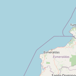
Map view of Refugio de Vida Silvestre Manglares Estuario Río Muisne

Use this park location map to pinpoint Refugio de Vida Silvestre Manglares Estuario Río Muisne in Ecuador, understand its exact geographic position, and read its mapped placement within the surrounding landscape more clearly.

Pigeon | © OpenStreetMap contributors

Location context for Refugio de Vida Silvestre Manglares Estuario Río Muisne

EsmeraldasManabí
Park atlas

Compare coastal wetlands and estuarine wildlife refuges across the surrounding region

Parks Near Refugio de Vida Silvestre Manglares Estuario Río Muisne and Regional Protected Areas

Browsing nearby national parks and protected coastal wetlands provides valuable context for comparing estuarine habitats. Exploring other reserves near Refugio de Vida Silvestre Manglares Estuario Río Muisne reveals broader regional patterns in Pacific shoreline conservation.
Nature reserveEsmeraldas
About 29 km away#1 closest

East

Reserva Ecológica Mache-Chindul: Coastal Mountain and Tropical Forest Protected Geography

Mapping the biodiversity of Esmeraldas provincial wilderness

Spanning over 119,000 hectares, Reserva Ecológica Mache-Chindul stands as a primary ecological shield against landscape degradation in coastal Ecuador. This site preserves rare mature forest mosaics, from dense Chocó lowland rainforest to misty high-altitude ridges. Gain geographic insight into this vital wilderness area through its distinct watershed basins and protected forest corridors.

Area
1,191.72 km²
Established
1996
IUCN
Ia
Relief
Mountain
Marine protected areaEsmeraldas
About 44 km away#2 closest

North

Reserva marina Galera San Francisco: Geographic Overview of the Marine Protected Area

Coastal cliffs, marine habitats, and regional landscape context in Esmeraldas

Reserva marina Galera San Francisco offers a unique look at the integration of terrestrial and oceanic ecosystems. From the cliff-lined coast of Esmeraldas to the depths of the Pacific, this protected area features coral zones, complex estuary systems, and vital nesting grounds. Examine the spatial distribution of these marine features and the geological formations that shape this coastal boundary through our structured geographic atlas.

Area
546.886 km²
Established
2008
IUCN
VI
Relief
Mixed relief
A horizontal watercolor painting showing layers of rolling green hills, a pink-toned foreground meadow, and distant hazy mountain ridgelines against a light background.
National parkImbabura
About 140 km away#3 closest

East

Cotacachi Cayapas National Park: A Study of Andean and Chocó Protected Geographic Landscapes

Exploring the extreme vertical transition across the northern Ecuadorian Andes

Cotacachi Cayapas National Park stands as a vital protected area, linking high-altitude páramo around Volcán Cotacachi to the lowland forests of the Chocó. The park features the iconic Laguna de Cuicocha and a dramatic range of ecosystems that define its complex terrain. This resource offers a clear look at the park's boundaries, geological features, and the distinct ecological zones that make it a central pillar of northern Ecuadorian geography.

Area
2,609.61 km²
Established
1968
IUCN
II
Visitors
50.2K annual
Nature reserveEsmeraldas
About 157 km away#4 closest

Northeast

Reserva ecológica Manglares Cayapas-Mataje: Mapped Coastal Wetland and Protected Landscape

A vast estuarine and mangrove refuge in the Esmeraldas province of Ecuador.

The Reserva ecológica Manglares Cayapas-Mataje spans over 49,000 hectares of diverse coastal terrain, including tidal estuaries, guandales, and tropical lowland forests. As a Ramsar-recognized wetland, this reserve preserves critical connectivity between riverine basins and the Pacific Ocean, acting as a vital geographic anchor for Chocó endemic species and complex aquatic habitats within the Esmeraldas region.

Area
490.71 km²
Established
1995
Relief
Lowland
Climate
Tropical
A wide watercolor illustration showing a misty landscape with green trees in the midground and faint mountain peaks in the background.
Nature reserveEcuador
About 159 km away#5 closest

Southeast

Reserva Ecológica Los Illinizas: Geographic Atlas and Andean Protected Nature Reserve

Volcanic terrain and cloud forest ecosystems in central Ecuador

Spanning across the provinces of Cotopaxi, Pichincha, and Santo Domingo de los Tsáchilas, Reserva Ecológica Los Illinizas preserves a significant vertical gradient of Andean ecosystems. The reserve protects the western flanks of the Illiniza volcanoes, Quilotoa, and El Corazón, offering a detailed look at high-altitude biodiversity and the transition from rugged mountain peaks to lush western cloud forests.

Area
1,342.33 km²
Established
1996
IUCN
Ia
Relief
Mountain
Wildlife reserveManabí
About 178 km away#6 closest

Southwest

Refugio de Vida Silvestre Marino Costera Pacoche: Geography and Protected Area Atlas

Coastal and forest protected landscapes in Manabí, Ecuador

Examine the unique geographic structure of Refugio de Vida Silvestre Marino Costera Pacoche, a protected reserve bridging the Tumbesian dry forest and the Pacific Ocean. This atlas entry focuses on the park's coastal cliffs, sediment-rich marine zones, and forest ridges, providing a clear visual and descriptive record of this ecologically significant Manabí sanctuary.

Established
2008
IUCN
V
Visitors
3.2K annual
Relief
Mixed relief
Watercolor illustration showing a panoramic view of a wide valley with green hills, a small stream, and forested clusters, rendered in a light and airy style.
Nature reservePichincha
About 197 km away#7 closest

East

Reserva Geobotánica Pululahua: Protected Volcanic Caldera and Highland Ecosystems

A distinct geobotanical reserve in the Pichincha region of the Ecuadorian Andes.

Reserva Geobotánica Pululahua is a protected natural area centered on a massive, 12-kilometer-wide volcanic caldera. Its landscape features three prominent lava domes and a rare altitudinal gradient of vegetation, spanning from semi-dry mountain shrubland to dense cloud forest. This reserve serves as a critical study of volcanic geology and human-landscape interaction in the high Andes, offering a concentrated look at Ecuador's vertical ecological zonation.

Area
34.417 km²
Established
1966
Relief
Mountain
Climate
Subtropical
National parkManabí Province
About 201 km away#8 closest

South

Machalilla National Park: Protected Area and Geographic Context in Manabí Province

Explore mapped natural landscapes and regional geography.

Delve into Machalilla National Park, a protected national park situated in Ecuador's Manabí Province. This page provides a focused view on its protected landscape character, emphasizing its geographic setting and mapped natural terrain. Understand how Machalilla National Park fits into the regional geography, offering a distinct case study for protected-area discovery and landscape atlas exploration.

Area
750.59 km²
Established
1979
IUCN
II

Common questions about visiting, size, designation, and location context for Refugio de Vida Silvestre Manglares Estuario Río Muisne

Refugio de Vida Silvestre Manglares Estuario Río Muisne FAQs for park facts, access, geography, and protected area context

Find quick answers about Refugio de Vida Silvestre Manglares Estuario Río Muisne, including protected-area facts, park geography, trail and visitor context, and how the park fits into its surrounding country and regional landscape.
MoriAtlas Explorer

Continue Your Protected Areas Search Across the Global Atlas

Deepen your exploration by continuing the structured search for national parks and protected areas worldwide. Utilize the comprehensive filtering capabilities to compare different conservation landscapes and refine your understanding of global park geography. Discover more about the distribution and characteristics of protected natural areas.

Global natural geography

