
Mori Atlas logo
Nature reserveRéserve naturelle régionale des Sauvages

Examining the Mapped Boundaries and Diverse Habitat Transitions of this Limousin Nature Reserve

Réserve naturelle régionale des Sauvages: A Protected Landscape and Ecological Mosaic in Nouvelle-Aquitaine

(Réserve naturelle régionale des Sauvages (RNR308))

The Réserve naturelle régionale des Sauvages represents a significant protected area within the Haute-Vienne department of Nouvelle-Aquitaine. This reserve encompasses a compact yet complex landscape where heather moorland, peatland, mature beech forests, and medieval ponds converge to create a unique habitat mosaic. Through its proximity to other regional conservation lands, the reserve contributes to a vital network of protected environments in the central-western highlands of France.

regional nature reserveheathlandpeatlandbeech forestpondsLimousin
A stylized digital illustration of a forest scene with a central waterfall flowing into a calm lake, surrounded by cliffs, trees, and greenery under a soft sunset sky.

Réserve naturelle régionale des Sauvages

Nature reserve

Park overview

Structured park overview, official facts, and landscape profile for Réserve naturelle régionale des Sauvages

Réserve naturelle régionale des Sauvages park facts, protected area profile, and essential visitor context

Review the core facts for Réserve naturelle régionale des Sauvages, including designation, size, terrain, visitor scale, habitats, and operating context in one park-focused overview.

About Réserve naturelle régionale des Sauvages

Réserve naturelle régionale des Sauvages is a modest but ecologically rich protected area in central-western France. Designated in 2015 and managed by the Conservatoire d'espaces naturels du Limousin, it covers about 82 hectares in the Haute-Vienne department, on the territory of the commune of Saint-Sylvestre. Although small by national park or large regional park standards, the reserve is structurally significant because it protects an unusually varied mosaic of habitats within a single boundary.

The defining character of the reserve lies in its combination of open and forested landscapes. Heather-dominated landes, or moorlands, share the terrain with traditional meadows, peat-forming wetlands, and stretches of mature beech forest that have likely escaped intensive management for a considerable time. Three small ponds, originally dug in the medieval period, add a further aquatic and semi-aquatic layer to the habitat mix. The result is a place where dry heath, damp peatland, shady forest, open grassland, and standing water all occur within close proximity, supporting diverse communities of plants and animals.

Sauvages is not an isolated reserve. It lies immediately next to the Réserve naturelle nationale de la tourbière des Dauges, a national nature reserve that protects one of the better-known peat bog complexes of the Limousin. The two reserves are functionally aligned: Sauvages provides complementary habitats, buffer zones, and ecological transition areas around the peatland core. This pairing gives the reserve a significance greater than its surface area alone would suggest, anchoring it within a wider system of protected natural landscapes in the Haute-Vienne.

In the broader French picture, the reserve fits into the network of réserves naturelles régionales (RNR), a category of protection governed at the regional level, designed to safeguard biodiversity, natural heritage, and traditional landscapes outside the national park and national nature reserve systems. Its IUCN Category IV status places it among reserves managed primarily for the protection of specific habitats and species, typically through targeted interventions rather than full wilderness designation. For visitors and researchers interested in the natural heritage of the Limousin, Sauvages offers a representative example of the region's surviving mosaic of heath, bog, and beech forest landcapes.

Quick facts and research context for Réserve naturelle régionale des Sauvages

The Réserve naturelle régionale des Sauvages is classified as a regional nature reserve (réserve naturelle régionale) under IUCN Category IV, meaning it is managed primarily for habitat and species conservation through active intervention. Covering 82.57 hectares in the Haute-Vienne department, it was established by a regional council deliberation on 20 November 2015.

Its position within the commune of Saint-Sylvestre places the reserve directly alongside the Réserve naturelle nationale de la tourbière des Dauges, creating a paired system of complementary protection zones. Management is handled by the Conservatoire d'espaces naturels du Limousin, a regional conservation body with experience in protecting peatlands, heathlands, and old-growth woodland across the former Limousin region.

Protection and recognition

Explore documented terrestrial conservation measures and official protected area records

Protection Status and International Recognition for Réserve naturelle régionale des Sauvages

Terrestrial protection status records provide a structured overview of conservation boundaries for Réserve naturelle régionale des Sauvages. Official management parameters outline the documented administrative framework without assuming external international recognitions.

Protection details

Protection scope
Terrestrial
Transboundary protection
No
WDPA ID
555597287
Park context

Deeper park guide and search-rich context for Réserve naturelle régionale des Sauvages

Réserve naturelle régionale des Sauvages history, landscape, wildlife, and travel context

Explore Réserve naturelle régionale des Sauvages through its history, landscape character, ecosystems, wildlife, conservation priorities, cultural context, and seasonal travel timing in a structured park guide built for atlas discovery and search intent.

Why Réserve naturelle régionale des Sauvages stands out

Sauvages is best known for the diversity of habitats compressed into a small area. The reserve combines heather moorland, peatland, old beech forest, meadows, and medieval-era ponds within a single protected boundary. This ecological mosaic is unusual for regional reserves of this size and is the defining feature of the site. Its proximity to the better-known Dauges peat bog national reserve also gives Sauvages a notable role in the wider conservation geography of the Haute-Vienne. Together, the two reserves form a connected landscape of wet and semi-natural habitats at the heart of the Limousin countryside.
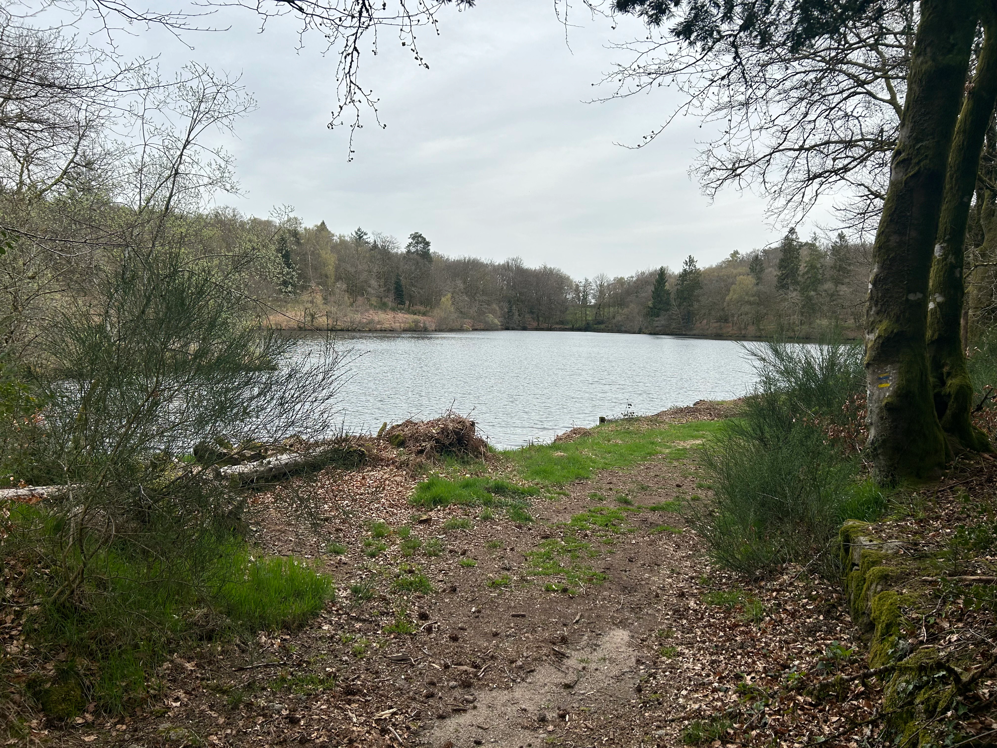
A calm lake surrounded by trees and vegetation, viewed from a dirt path in the forest.
A peaceful view of the lake within the Réserve naturelle régionale des Sauvages.

Réserve naturelle régionale des Sauvages history and protected-area timeline

The Réserve naturelle régionale des Sauvages was formally established by deliberation of the Conseil régional on 20 November 2015. This step created the legal protection framework for an area whose ecological value had been recognized locally but which had not previously benefited from regional nature reserve status.

Management responsibility was assigned to the Conservatoire d'espaces naturels du Limousin, an organization already engaged in protecting similar habitats elsewhere in the former Limousin region. The institution brings relevant expertise in peatland conservation, heathland management, and the protection of mature woodland, all of which are relevant to the Sauvages site. The 2018 scientific article by Véronique Lucain in the Annales Scientifiques du Limousin provides early scholarly documentation of the reserve and its features.

The reserve's history is also shaped by its physical features. The presence of three ponds of medieval origin indicates long-standing human modification of the landscape, suggesting that the area has been shaped by grazing, pond-digging, and traditional land use for centuries. Today, protection aims to preserve the ecological heritage that has resulted from this long interaction between human activity and natural processes.

Réserve naturelle régionale des Sauvages landscape and geographic character

The landscape of the Réserve naturelle régionale des Sauvages is shaped by the gentle topography typical of the Haute-Vienne and the broader Limousin region. Elevation changes are modest, and the terrain is characterized by a softly undulating mix of forest, heath, meadow, and wetland. Rather than dramatic relief, the reserve's visual character comes from the transitions between habitats, with heather moorland giving way to boggy depressions, then to beech woodland stands, then to open meadows and ponds.

Heathland, or landes, dominates the drier ground, while peat-forming hollows occupy the wetter low points. Mature beech forest forms a denser wooded layer in places, providing shade and leaf-litter habitats that contrast with the open expanse of the moorland. The three ponds, created during the medieval period, are small but visually distinctive features that interrupt the vegetation mosaic with calm expanses of open water. Together, these elements create a layered landscape mosaic where light, vegetation, and moisture combine in constantly varying patterns.

Réserve naturelle régionale des Sauvages ecosystems, habitats, and plant life

Ecologically, Sauvages is defined by the close coexistence of several distinct habitat types within a small area. Heather-dominated landes support heathland flora and fauna adapted to acidic, nutrient-poor soils. Peatland formations, present in boggy ground, contribute to carbon storage and host moisture-loving plant communities. Old beech forests contribute stable, shaded woodland habitat with their own distinctive species assemblage. Meadows provide open conditions with diverse herbaceous vegetation. The three medieval ponds introduce aquatic and wetland edge habitats.

This habitat diversity is the reserve's strongest ecological feature. Because the different habitat types are tightly interwoven across only about 82 hectares, the reserve functions almost like a microcosm of the broader Limousin landscape, where heath, bog, forest, and traditional farmland once coexisted more widely. The presence of peatland is particularly significant from a regional perspective, given the long-term loss of such habitats across western Europe.

Réserve naturelle régionale des Sauvages conservation status and protection priorities

The reserve plays a role in maintaining habitat continuity around the Dauges peat bog national nature reserve, providing ecologically complementary buffer zones to one of the notable peatland complexes of the region. By protecting heathland, peatland, mature beech forest, meadows, and ponds together, Sauvages helps preserve the structural diversity that many species require.

The involvement of the Conservatoire d'espaces naturels du Limousin as the managing body reflects an active conservation approach typical of IUCN Category IV reserves. Management likely combines habitat maintenance, monitoring, and restoration, consistent with the Conservatoire's broader role protecting similar environments elsewhere in the Limousin.

Réserve naturelle régionale des Sauvages cultural meaning and human context

The presence of three ponds of medieval origin is a reminder of how long the relationship between people and this landscape has been. The Limousin countryside has historically been shaped by small-scale agriculture, grazing, woodland management, and pond creation for fish and water use. The Sauvages reserve preserves not only natural habitats but also traces of this long human presence in the landscape, even though detailed human-history documentation in the source material is limited.

Top sights and standout views in Réserve naturelle régionale des Sauvages

A compact reserve where heathland, peatland, old beech forest, meadows, and medieval ponds all coexist within a single protected boundary. The reserve's proximity to the Dauges peat bog national nature reserve adds regional significance, creating a connected conservation landscape in the Haute-Vienne.

Best time to visit Réserve naturelle régionale des Sauvages

Without detailed seasonal information in the source material, general guidance for the Haute-Vienne and the Limousin applies. Late spring and early summer bring active vegetation and breeding bird activity. Summer highlights heathland and meadow flora. Autumn reveals beech forest color and fungal interest. Winters are generally mild but wet, with reduced outdoor access to boggy ground. Specific seasonal access arrangements for the reserve are not documented in the source material.
Monthly climate preview

Long term monthly temperature averages and precipitation records for Nouvelle-Aquitaine

Réserve naturelle régionale des Sauvages Climate Normals and Temperature Rhythms

Analysis of NASA POWER climatology data reveals measured monthly temperature and precipitation ranges recorded at a representative elevation point within Réserve naturelle régionale des Sauvages. Reviewing the complete twelve-month profile provides detailed contextual depth regarding long-term environmental patterns across the protected landscape.
Annual mean11 °C
3 °C20 °C
Jan
Feb
Mar
Apr
May13°
Jun17°
Jul20°
Aug20°
Sep16°
Oct12°
Nov
Dec
Warmest month
August

20.2 °C

Coolest month
January

3.3 °C

Wettest month
November

3 mm/day

Driest month
July

1.9 mm/day

Park location guide

Geography guide, regional context, and park location map for Réserve naturelle régionale des Sauvages

Réserve naturelle régionale des Sauvages park geography, regions, and map view in France

Understand where Réserve naturelle régionale des Sauvages sits in France through a broader geographic reading of the surrounding landscape, nearby location context, and its mapped position within the national park landscape.

How Réserve naturelle régionale des Sauvages fits into France

France is a unitary semi-presidential republic and one of the world's largest economies. It borders Belgium, Luxembourg, Germany, Switzerland, Italy, Monaco, Andorra, and Spain, with a maritime border to the United Kingdom. The country is known for its cultural influence, art, cuisine, and political history spanning centuries.

Wider geography shaping Réserve naturelle régionale des Sauvages in France

France is located in Western Europe. Metropolitan France extends from the Rhine to the Atlantic Ocean and from the Mediterranean Sea to the English Channel and North Sea. The country borders Belgium, Luxembourg, Germany, Switzerland, Italy, Monaco, Andorra, Spain, and has a maritime border with the United Kingdom.

Map view of Réserve naturelle régionale des Sauvages

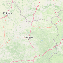
Use this park location map to pinpoint Réserve naturelle régionale des Sauvages in France, understand its exact geographic position, and read its mapped placement within the surrounding landscape more clearly.

Pigeon | © OpenStreetMap contributors

Location context for Réserve naturelle régionale des Sauvages

Nouvelle-Aquitaine

Visualizing the habitats, peatlands, and terrain of the protected Limousin reserve

Réserve Naturelle Régionale des Sauvages Landscape Photography and Park Scenery

Protected area imagery reveals the compact mosaic of heather moorland, mature beech woodland, and medieval ponds defining the reserve. Visual exploration maps the terrain and habitat transitions across the Haute-Vienne highlands.

A calm lake surrounded by trees and vegetation, viewed from a dirt path in the forest.

Park atlas

Compare regional nature reserves and connected conservation areas across the HauteVienne highlands.

Explore Parks Near Réserve naturelle régionale des Sauvages and Surrounding Protected Landscapes

Browse protected areas adjacent to Réserve naturelle régionale des Sauvages to examine wider wetland mosaics and forest habitats. Extending your study across the surrounding region reveals how connected nature reserves maintain regional biodiversity.
Nature reserveNouvelle-Aquitaine
About 43 km away#1 closest

Southwest

Réserve naturelle régionale du réseau de landes atlantiques du Parc naturel régional Périgord-Limousin

A networked regional nature reserve in Nouvelle-Aquitaine.

This protected area serves as a critical network of Atlantic heathland sites embedded within the larger Périgord-Limousin Regional Natural Park. By conserving these scattered clearings of acidic soil and low vegetation, the reserve maintains a distinct biogeographic feature far from the French coast, offering a clear view into how regional authorities manage fragmented open habitats in the Haute-Vienne.

Area
0.409 km²
Established
2015
IUCN
IV
Scope
Terrestrial
A soft watercolor painting of a wide, gently rolling landscape with green fields, forested hills in the distance, and native vegetation in the foreground.
Nature reserveHaute-Vienne
About 46 km away#2 closest

South

Lande de la Flotte et du Cluzeau: Geological Landscapes of Haute-Vienne, France

Nature reserve featuring rare serpentinite heathland habitats

Lande de la Flotte et du Cluzeau preserves a rare type of serpentine heathland on the Limousin plateau. By protecting stony outcrops that contrast with the local forest and farmland, this reserve maintains a significant botanical environment within Haute-Vienne, reflecting the complex metamorphic history of the region.

Area
132 km²
Established
1993
IUCN
IV
A horizontal watercolor illustration depicting a soft landscape with rolling hills, a body of water in the foreground, and pine trees on the right side.
Nature reserveNouvelle-Aquitaine
About 63 km away#3 closest

Southeast

Réserve naturelle régionale de la haute vallée de la Vézère: Protected Highland Geography

Wetland ecosystems of the Corrèze and Plateau de Millevaches.

Representing a vital network of peatland and bog systems, this nature reserve in the Nouvelle-Aquitaine region preserves essential highland habitats. Its scattered parcels illustrate the complex wetland geography of the Massif Central, offering a focused look at how protected boundaries safeguard specialized ecosystems within the upper Vézère river catchment area.

Area
1.963 km²
Established
2015
IUCN
IV
Relief
Lowland
Nature reserveCharente
About 71 km away#4 closest

Southwest

Val de Tardoire Nature Reserve: Geography and Protected Area Mapping in Charente

A detailed river valley landscape in Nouvelle-Aquitaine, France.

This protected area centers on the Tardoire river valley, featuring a high density of wet meadows, broadleaf forests, and rocky escarpments. The site represents a crucial node for European-interest habitats and diverse fauna, offering an in-depth look at the natural terrain and ecological composition of the Charente department.

Area
31.49 km²
Established
1999
Relief
Upland
Climate
Temperate
Nature reserveNouvelle-Aquitaine
About 75 km away#5 closest

Southwest

Réserve naturelle régionale de la vallée de la Renaudie Protected Landscape and Map Atlas

A geological crossroads in the heart of Nouvelle-Aquitaine.

Trace the 6 kilometer stretch of the Réserve naturelle régionale de la vallée de la Renaudie. This protected area showcases an unusual geological interface between limestone and granite, creating a compact mosaic of riparian woodland, dry rocky cliffs, and meadows that support significant regional biodiversity.

Area
0.73 km²
Established
2012
IUCN
IV
Relief
Mixed relief
Nature reserveCentre-Val de Loire
About 79 km away#6 closest

North

Réserve naturelle régionale des terres et étangs de Brenne, Massé, Foucault Geographic Details

A managed wetland landscape in the Centre-Val de Loire

Analyze the terrain of the Réserve naturelle régionale des terres et étangs de Brenne, Massé, Foucault. This reserve showcases a dense network of freshwater ponds and diverse plant communities, including rare species like the marsh gentian, across a finely textured wetland environment in central France.

Area
3.19 km²
Established
2014
IUCN
IV
Relief
Lowland
Watercolor painting of a winding river flowing through a grassy plain, with soft green hills in the distance and a large rock in the foreground.
Nature reserveCentre-Val de Loire
About 81 km away#7 closest

North

Réserve naturelle régionale du Bois des Roches: Geographic Overview and Protected Area Atlas

Limestone cliffs and archaeological landscapes in Centre-Val de Loire

Situated in the Indre department of France, this nature reserve is defined by its south-facing limestone cliffs and diverse ecological layers. Beyond its role as a sanctuary for bat colonies and thermophilic flora, the site reveals a deep history of Upper Paleolithic human occupation. MoriAtlas provides a comprehensive geographic look at this protected landscape and its structural role within the broader Brenne ecological context.

Area
0.122 km²
Established
1997
IUCN
IV
Relief
Upland
Nature reserveNouvelle-Aquitaine
About 81 km away#8 closest

Southwest

Vallée de la Nizonne Nature Reserve: Mapped Geography and Protected Wetland Landscapes

A critical river corridor and Natura 2000 conservation zone in Nouvelle-Aquitaine.

Discover the geographic structure of the Vallée de la Nizonne, a protected area shaped by the flow of the Nizonne and Lizonne rivers. This landscape mosaic features peatlands, wet meadows, and alluvial forests that serve as a refuge for rare species. Gain insight into the regional terrain and conservation boundaries that define this important French wetland corridor.

Area
33.91 km²
Established
2016
Relief
Upland
Climate
Temperate

Common questions about visiting, size, designation, and location context for Réserve naturelle régionale des Sauvages

Réserve naturelle régionale des Sauvages FAQs for park facts, access, geography, and protected area context

Find quick answers about Réserve naturelle régionale des Sauvages, including protected-area facts, park geography, trail and visitor context, and how the park fits into its surrounding country and regional landscape.
MoriAtlas Explorer

Continue Your Protected Areas Search Across the Global Atlas

Deepen your exploration by continuing the structured search for national parks and protected areas worldwide. Utilize the comprehensive filtering capabilities to compare different conservation landscapes and refine your understanding of global park geography. Discover more about the distribution and characteristics of protected natural areas.

Global natural geography