
Mori Atlas logo
Nature reserveRiedried

Mapped terrain, peatland habitats, and regional landscape context in Rhineland-Palatinate

Riedried Nature Reserve: Exploring the Geography of Protected Wetlands in the Bienwald

Riedried stands as a vital nature reserve on the eastern edge of the Bienwald forest in Germany. This protected area preserves a rare mosaic of black alder swamp forest and lowland peat bog, forming an ecologically distinct wetland core within the broader Rhine plain. Discover how this compact landscape maintains essential habitat features through precise site management and regional conservation efforts.

wetlandswamp forestalder forestlowland peatnature reserveRhineland-Palatinate
A flat, vector-style illustration of a valley between steep mountain cliffs, featuring a small waterfall, a river, a pine forest, and stylized clouds in a pastel-colored landscape.

Riedried

Nature reserve

Park overview

Structured park overview, official facts, and landscape profile for Riedried

Riedried park facts, protected area profile, and essential visitor context

Review the core facts for Riedried, including designation, size, terrain, visitor scale, habitats, and operating context in one park-focused overview.

About Riedried

Riedried is a compact nature reserve in the German state of Rhineland-Palatinate, situated in the eastern fringe of the Bienwald, one of the largest contiguous forest areas on the Upper Rhine plain. The reserve lies in the cadastral area of Büchelberg, a district of Wörth am Rhein, and is surrounded by a landscape shaped by forestry, agriculture, and infrastructure corridors such as the B 9 federal road and the A 65 motorway.

Although small in area, the reserve has a clearly defined ecological identity. Its core habitat is a black alder swamp forest, a wet woodland type dominated by alder trees and occurring on periodically waterlogged, peaty soils. Within this swamp forest lies a small lowland peat bog, an unusual feature for the region, and an open meadow that maintains rare plant communities. These habitats together form a layered wetland ecosystem supporting a specialized set of species tied to wet, nutrient-rich, and boggy conditions.

The site was placed under formal protection in 1984, and its designation as a Naturschutzgebiet reflects a habitat and species management approach rather than a landscape-scale wilderness designation. As part of the wider network of nature reserves in the Germersheim district, Riedried serves as a local refuge for wetland biodiversity in an otherwise largely dry and cultivated part of the Rhine plain.

Quick facts and research context for Riedried

Riedried is a nature reserve of approximately 25 hectares in the district of Germersheim in Rhineland-Palatinate, Germany. It sits southwest of Wörth am Rhein in the eastern edge of the Bienwald forest, near major roads including the B 9 and A 65. The site was officially designated as a protected area on 24 October 1984 under Rhineland-Palatinate nature conservation law. It is classified as an IUCN Category IV habitat and species management area, reflecting its small-scale, biodiversity-focused conservation role. The reserve is best understood as a compact wetland forest mosaic rather than a large landscape-scale park.

Protection and recognition

Analysis of terrestrial protection scope and recognized designations

Riedried Protection Status and Documented Conservation Framework

Riedried maintains a defined terrestrial protection scope within the global conservation registry. Documented metrics outline the administrative classification and verified status records associated with this protected area.

Protection details

Protection scope
Terrestrial
WDPA ID
165177
Park context

Deeper park guide and search-rich context for Riedried

Riedried history, landscape, wildlife, and travel context

Explore Riedried through its history, landscape character, ecosystems, wildlife, conservation priorities, cultural context, and seasonal travel timing in a structured park guide built for atlas discovery and search intent.

Why Riedried stands out

Riedried is best known for its protected black alder swamp forest, called Schwarzerlenbruch in German, along with the lowland peat bog embedded within it. This rare combination of wet woodland and open boggy meadow in the eastern Bienwald makes the reserve a small but ecologically distinctive site. The reserve's conservation purpose emphasizes preserving not only the trees and peat substrate but also the rare plant communities of the meadow and the animal species that depend on this particular wetland ecosystem. Such a focused mix of habitats is relatively unusual in the otherwise dry Rhine plain landscape of Rhineland-Palatinate.
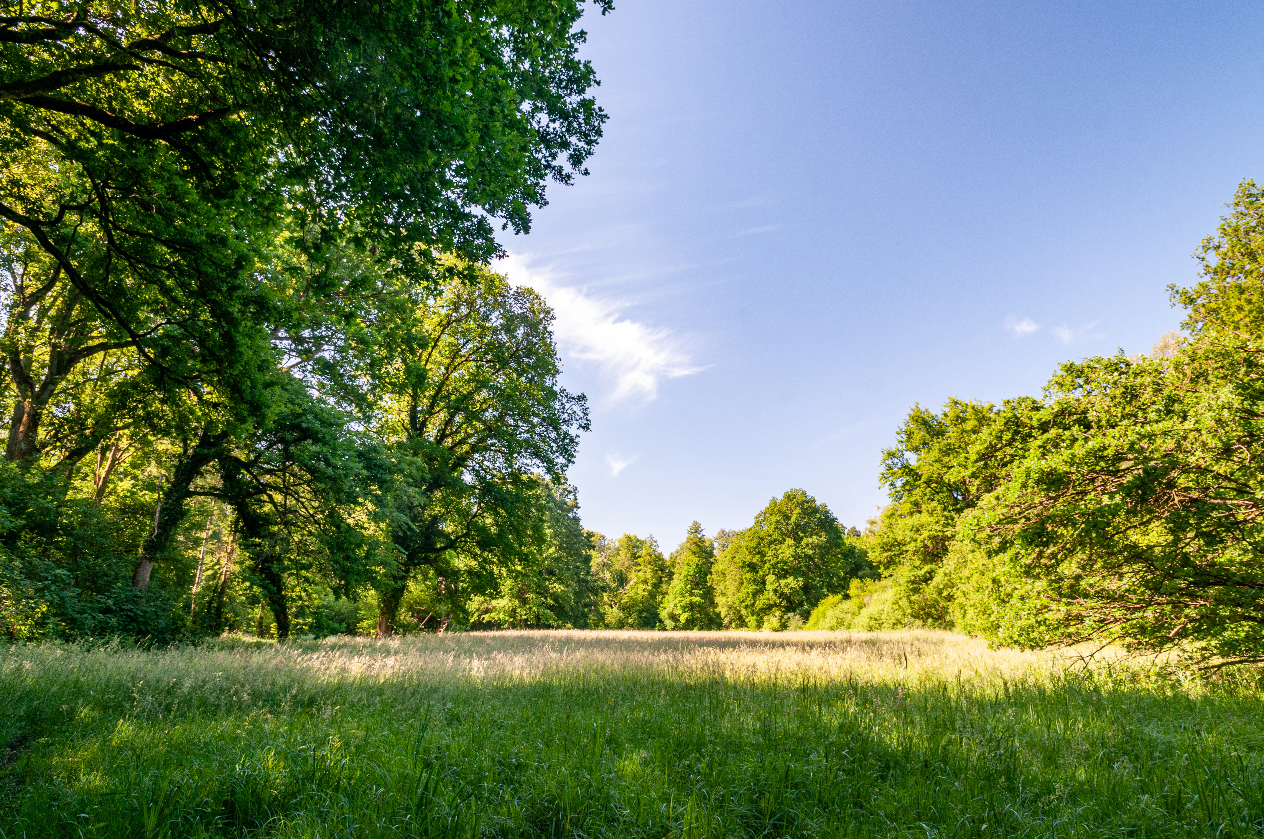
A wide, sunny meadow surrounded by large deciduous trees under a clear blue sky.
A sunny clearing surrounded by dense forest in the Riedried nature reserve.

Riedried history and protected-area timeline

Riedried was formally established as a nature reserve (Naturschutzgebiet) on 24 October 1984 under Rhineland-Palatinate nature conservation legislation. The designation came as part of broader efforts in the 1980s to protect the remaining small wetland and forest habitats of the Upper Rhine plain, many of which had been reduced by agricultural drainage, peat extraction, and development pressures.

The reserve's current protection status places it in IUCN Category IV, indicating that it is managed primarily for the conservation of specific habitats and species rather than for broad ecological processes. Since its designation, Riedried has been embedded within the regional network of protected sites in the Germersheim district, alongside other wetland and forest reserves such as the Bruchbach-Otterbachniederung and the Lauterniederung.

Riedried landscape and geographic character

Riedried occupies a small but visually distinct patch of wet landscape within the otherwise largely dry Bienwald forest region. The reserve's terrain is flat, typical of the Upper Rhine plain, but its wet woodland, embedded peat bog, and open meadow create a finely textured mosaic of habitats. Surrounding the reserve, the broader landscape combines broadleaf and mixed forest of the Bienwald with agricultural land and transport corridors.

The reserve itself is essentially a green depression in the forest, defined by the dark tones of alder canopy, the soft ground of peat soils, and the lighter grasses of the meadow. Although the topography is gentle and the area is small, the contrast between the wet core of the reserve and the drier surrounding forest gives Riedried a clearly recognizable character within the regional landscape.

Riedried ecosystems, habitats, and plant life

The ecological identity of Riedried is built around three connected wetland habitats: black alder swamp forest, lowland peat bog, and a species-rich open meadow. The swamp forest is the dominant habitat, characterized by alder trees adapted to permanently or seasonally waterlogged soils. Embedded within it is a lowland peat formation, a relatively rare habitat in Rhineland-Palatinate that supports moisture-loving plant communities typical of boggy ground.

The open meadow component of the reserve adds diversity to the ecological structure, providing habitat for plant species that require lighter, less shaded conditions than the dense alder canopy. This combination of shaded wet woodland, open peatland, and grassland creates a mosaic that supports a broader range of species than any single habitat could sustain on its own, making the reserve ecologically dense despite its small size.

Riedried wildlife and species highlights

Riedried's wildlife value is closely linked to its specific wetland habitats. The reserve protects animal species that are tied to wet alder forests, lowland peat bogs, and the wet meadow habitats adjoining them. Such sites often support amphibian populations, wetland-specialist invertebrates, and bird species associated with wet woodland and boggy openings.

Because the reserve is small, its significance for wildlife lies less in the absolute number of species present and more in its role as a refuge for species that have become rare elsewhere in the surrounding, drier landscape. The combination of swamp forest, peat, and meadow provides a varied vertical and moisture structure that supports fauna adapted to multiple wetland microhabitats within a very compact area.

Riedried conservation status and protection priorities

Riedried is a conservation-focused reserve managed primarily for the long-term preservation of its specific habitat mosaic. Its protection purpose explicitly targets the maintenance of the natural black alder swamp forest, the embedded lowland peat bog, and the meadow supporting rare plant communities, along with the rare and threatened animal species tied to these habitats.

As an IUCN Category IV protected area, Riedried is designated as a Habitat and Species Management Area, which means its management is aimed at maintaining particular habitat conditions and species populations rather than allowing broad ecological processes to operate freely. In the broader context of the Upper Rhine plain, where wetland habitats have been heavily reduced, Riedried functions as a small but important refuge that helps preserve the regional biodiversity of wet woodland and bog ecosystems.

Riedried cultural meaning and human context

Riedried sits in a region with long-standing human management of woodland and wetland resources. The Bienwald has historically been a working forest landscape, and the small communities of Büchelberg and Wörth am Rhein have traditional ties to forestry, agriculture, and the Rhine trade routes. The reserve represents a modern shift in this relationship: a small patch of formerly used land now managed primarily for biodiversity rather than resource extraction.

While the reserve itself is not a cultural heritage site, its designation reflects the growing regional recognition in Rhineland-Palatinate of the value of preserving small but ecologically distinctive wetland sites within a heavily modified cultural landscape.

Top sights and standout views in Riedried

Riedried's defining strength is its combination of a black alder swamp forest with an embedded lowland peat bog and an associated meadow, all within a compact 25-hectare protected area. This fine-scale mosaic of wetland habitats is the core reason the reserve exists and continues to be protected.

Another distinguishing point is its location on the eastern edge of the Bienwald, where it forms part of a wider network of small nature reserves in the Germersheim district that collectively maintain patches of wet woodland and bog habitat across the Rhine plain. For visitors and conservation-minded observers, Riedried offers a focused example of how very small protected areas can preserve regionally rare ecological features.

Best time to visit Riedried

Because Riedried is a small nature reserve focused on conservation rather than tourism infrastructure, visits are limited to observing the reserve from its perimeter and quiet walking along nearby forest tracks. The most atmospheric period tends to be late spring and early summer, when the alder forest is in full leaf and the meadow is in bloom, offering the richest mix of forest and open habitat experience.

Late autumn and winter bring a quieter atmosphere, when bare deciduous trees reveal more of the reserve's internal structure, and wetland ground conditions are most visible. These cooler seasons are generally well suited to observing the hydrological character of the site without disturbing sensitive breeding or growing-season habitats.

Monthly climate preview

Track multi-year temperature ranges and precipitation averages across the park coordinate

Riedried Climate Normals and Long-Term Monthly Weather Profiles

Historical data compiled from NASA POWER records between 1991 and 2020 documents monthly temperature and precipitation rhythms across Riedried. Detailed monthly comparisons provide deeper analytical depth for studying long-term environmental conditions at this representative coordinate.
Annual mean10 °C
1 °C21 °C
Jan
Feb
Mar
Apr10°
May15°
Jun19°
Jul21°
Aug20°
Sep16°
Oct10°
Nov
Dec
Warmest month
July

20.9 °C

Coolest month
January

0.6 °C

Wettest month
May

2.3 mm/day

Driest month
April

1.5 mm/day

Park location guide

Geography guide, regional context, and park location map for Riedried

Riedried park geography, regions, and map view in Germany

Understand where Riedried sits in Germany through a broader geographic reading of the surrounding landscape, nearby location context, and its mapped position within the national park landscape.

How Riedried fits into Germany

Germany is a federal republic in Western and Central Europe with a population of over 83 million across sixteen constituent states. It is Europe's largest economy by nominal GDP and a major global exporter and importer. The capital is Berlin, and the country borders Denmark, Poland, Czech Republic, Austria, Switzerland, France, Luxembourg, Belgium, and the Netherlands.

Wider geography shaping Riedried in Germany

Germany is located in Western and Central Europe, spanning 357,022 km². It borders Denmark to the north, Poland and the Czech Republic to the east, Austria and Switzerland to the south, and France, Luxembourg, Belgium, and the Netherlands to the west. The country has coastlines on the Baltic Sea and North Sea to the north, with the Alps located in the southern region.

Map view of Riedried

Use this park location map to pinpoint Riedried in Germany, understand its exact geographic position, and read its mapped placement within the surrounding landscape more clearly.

Pigeon | © OpenStreetMap contributors

Explore protected area views, black alder swamp forest terrain, and lowland peat habitats.

Riedried Photos and Landscape Scenery: Visualizing the Wetland Nature Reserve

Visual documentation captures the rare black alder swamp forest, embedded lowland peat bog, and wet meadows defining the reserve environment. Examining these protected area views reveals the fine scale terrain and ecological character distinguishing the Rhine plain landscape.

A wide, sunny meadow surrounded by large deciduous trees under a clear blue sky.

Park atlas

Compare surrounding regional geography and adjacent wetland conservation landscapes

Explore Other Parks Near Riedried and Connected Protected Areas

Browse protected natural areas situated near Riedried to examine broader ecological patterns across the Rhine plain. Continuing into adjacent reserves reveals a wider network of wetland habitats and forested terrain shared throughout the regional ecosystem.
A watercolor painting showing a soft, atmospheric landscape with a foreground of water and green grasses, a midground of trees, and purple mountains in the background under a pale yellow sky.
Nature reserveRhineland-Palatinate
About 1.5 km away#1 closest

Southeast

Rheinniederung Neuburg-Wörth: A Protected Floodplain Landscape in Rhineland-Palatinate

An analysis of river meanders, oxbows, and floodplain forest geography

This nature reserve encompasses a 14.5 square kilometer corridor of the Upper Rhine, featuring a distinct topography of hardwood forests, wet meadows, and aquatic habitats. The site remains a focal point for understanding Rhine river dynamics and the conservation of rare floodplain ecosystems like the Wörther Altrhein.

Area
14.48 km²
Established
2004
Relief
Lowland
Climate
Temperate
A soft, watercolor painting of a wide landscape with a calm water body in the foreground, rolling green hills in the midground, and purple-toned distant mountains under a pale sky.
Nature reserveRhineland-Palatinate
About 7.3 km away#2 closest

Northwest

Bruchbach-Otterbachniederung Nature Reserve: Regional Floodplain and Wetland Geography

Mapping protected floodplain habitats along the Upper Rhine.

Bruchbach-Otterbachniederung is a landmark nature reserve in Rhineland-Palatinate, anchoring a continuous corridor of floodplain habitat from Rheinzabern to the French border. This protected area preserves a rare mosaic of reed beds, tall herb communities, and near-natural streams, providing essential sanctuary for regional flora and fauna within the southern Rhine lowlands.

Area
15.432 km²
Established
1988
IUCN
V
Relief
Lowland
A soft watercolor painting of a low-lying forest landscape with distant gentle hills and a stream in the foreground.
Protected landscapeRhineland-Palatinate
About 7.4 km away#3 closest

West

Bienwald Protected Landscape: Geographic Atlas and Regional Forest Context

Lowland forest dynamics in southern Rhineland-Palatinate

Bienwald is a distinct protected landscape in western Germany, forming one of the largest contiguous lowland forest complexes. Its geography is shaped by sandy alluvial fans and impermeable sub-layers that drive seasonal flooding patterns, supporting a diverse network of over 300 mapped biotope types across its level, woodland-covered terrain.

Area
120 km²
Established
1987
IUCN
V
Relief
Lowland
Nature reserveRheinland-Pfalz
About 7.4 km away#4 closest

West

FFH-Gebiet Bienwaldschwemmfächer: Geography and Protected Area Overview in Rheinland-Pfalz

Inland dunes, wet forests, and alluvial sediment landscapes

FFH-Gebiet Bienwaldschwemmfächer is a vital nature reserve in southeastern Rhineland-Pfalz, Germany. Spanning a massive alluvial fan created by historical river deposits, the area offers a study in habitat extremes. Discover how its unique wind-reworked sand dunes contrast with the moist forest interiors of the nasser Bienwald, supported by limestone-influenced fens that define its regional ecological significance.

Area
135.53 km²
Established
1998
Nature reserveRheinland-Pfalz
About 7.6 km away#5 closest

Northeast

Wörther Altrhein Nature Reserve: Protected Wetland Atlas and Upper Rhine Landscape Context

Mapped conservation zones within the Rheinland-Pfalz floodplain

Investigate the protected landscape of Wörther Altrhein, an ecologically important former Rhine channel. This site offers a unique study in wetland geography, where controlled hydrology supports diverse reedbeds and alluvial forest habitats within the industrial backdrop of the southern Upper Rhine.

Area
2.4 km²
Established
2004
IUCN
IV
Relief
Lowland
Watercolor painting of a tranquil wetland landscape with soft green vegetation and a calm water body, reflecting the floodplain environment of the Rhine river.
Nature reserveLandkreis Germersheim
About 7.8 km away#6 closest

Northeast

Hördter Rheinaue Nature Reserve: Landscape and Geographic Context in Landkreis Germersheim

Examining the hydrology and floodplain forest of the German Rhine.

Hördter Rheinaue serves as a critical node in the Palatinate Rhine floodplains, preserving a vast mosaic of willow and poplar forests alongside stable hardwood stands. Analyze the mapped terrain shaped by centuries of river activity, including the meandering Michelsbach and associated oxbow systems that define this essential protected corridor in western Germany.

Area
8.18 km²
Established
1966
IUCN
IV
Relief
Lowland
A soft, light watercolor painting of a wetland scene with a winding river branch, reeds, and low-lying greenery under a hazy sky.
Nature reserveRheinland-Pfalz
About 9.7 km away#7 closest

Northeast

Neupotzer Altrhein Nature Reserve: A Detailed Map and Geographic Overview

Protected floodplain landscape in the Rheinland-Pfalz region.

The Neupotzer Altrhein reserve stands as a prominent example of Rhine floodplain recovery, featuring a diverse topography of slow-moving water channels, marshes, and softwood alluvial forests. Located in the Rheinland-Pfalz district of Germersheim, this protected area offers significant insight into the historical and natural shifts of the Rhine corridor, serving as a key refuge within the European Natura 2000 network.

Area
2.375 km²
Established
2000
IUCN
IV
Relief
Lowland
Nature reserveRhineland-Palatinate
About 13 km away#8 closest

West

Lauterniederung Nature Reserve: Protected Floodplain Landscapes and Regional River Geography

A preserved riparian valley in Rhineland-Palatinate, Germany.

Lauterniederung provides a rare look at the original Auenlandschaft of the southern Palatinate. This nature reserve protects a meandering river channel and a diverse wetland mosaic of swamp forests and peat bogs, offering an essential geographic window into the natural history of the Upper Rhine Plain.

Area
2.07 km²
Established
1982
IUCN
IV

Common questions about visiting, size, designation, and location context for Riedried

Riedried FAQs for park facts, access, geography, and protected area context

Find quick answers about Riedried, including protected-area facts, park geography, trail and visitor context, and how the park fits into its surrounding country and regional landscape.
MoriAtlas Explorer

Continue Your Protected Areas Search Across the Global Atlas

Deepen your exploration by continuing the structured search for national parks and protected areas worldwide. Utilize the comprehensive filtering capabilities to compare different conservation landscapes and refine your understanding of global park geography. Discover more about the distribution and characteristics of protected natural areas.

Global natural geography