Why Río Clarillo National Park stands out
Río Clarillo is best known for its protection of the Cordilleran cypress (Austrocedrus chilensis), a distinctive conifer species native to the Andean foothills of central Chile. The park preserves one of the last remaining tracts of this natively occurring forest type in a region where such ecosystems have been heavily altered by human activity. It also serves as a living laboratory for understanding the central Chilean mediterranean ecosystem, with its characteristic combination of dry summers, seasonal vegetation patterns, and diverse native flora adapted to the climate.
Río Clarillo National Park history and protected-area timeline
Río Clarillo National Park was established in 1982 as a national reserve, with the dual purpose of environmental preservation and sustainable management of Chile's central forest resources. The creation of the protected area reflected growing recognition in Chile during the 1970s and 1980s of the need to safeguard remaining native forest ecosystems in the more densely populated and developed regions of the country. The park was subsequently reclassified as a national park, though it retains its alternate designation as Río Clarillo National Reserve in some official contexts. Management by the National Forest Corporation (CONAF) has focused on conservation of the native Cordilleran cypress forests and maintenance of the area's ecological integrity.
Río Clarillo National Park landscape and geographic character
The landscape of Río Clarillo National Park features the characteristic terrain of Chile's Andean foothills, with rolling mountain slopes, valleys carved by seasonal watercourses, and the prominent Río Clarillo itself flowing through the protected area. The terrain rises from lower foothills into higher ridgelines, creating a varied topography that supports different vegetation communities across elevation gradients. The park's drainage systems feed into the Maipo River basin, connecting the protected area to broader watershed systems serving the Santiago Metropolitan Region. Rock outcrops and exposed ridgelines punctuate the forested areas, adding visual diversity to the landscape.
Río Clarillo National Park ecosystems, habitats, and plant life
The park protects a representative example of the central Chilean mediterranean-type ecosystem, characterized by sclerophyllous vegetation adapted to seasonal dry conditions. The signature feature of Río Clarillo's natural environment is the presence of Cordilleran cypress forests, which represent a relict conifer community surviving in this latitude from more extensive prehistoric distributions. The vegetation structure includes mixtures of broadleaf and conifer species, with understory plants adapted to the canopy conditions and seasonal climate. This ecosystem type is considered one of the world's five mediterranean-climate regions and is renowned for its high degree of endemism and distinctive seasonal flowering patterns.
Río Clarillo National Park wildlife and species highlights
The fauna of Río Clarillo reflects the central Chilean biogeographic region, with species adapted to the seasonal mediterranean environment. The park provides habitat for native bird species characteristic of Chilean woodland and forest ecosystems, including various passerines and raptors that utilize the varied habitat structure. Small mammals, including several rodent species and the introduced European rabbit, occupy the terrain. The riparian corridors along the main watercourse support different species assemblages than the upland forest areas, creating habitat diversity within the relatively limited area.
Río Clarillo National Park conservation status and protection priorities
Río Clarillo National Park plays a crucial conservation role as one of the few protected areas preserving native forest ecosystems in the heavily populated Santiago Metropolitan Region. The park's establishment recognized that central Chile's natural environments faced significant pressure from agriculture, forestry, and urban expansion, making protected spaces essential for maintaining biodiversity and ecosystem processes. The Cordilleran cypress stands represent a conservation priority given the species' restricted distribution and historical reduction across its range. The IUCN Category IV designation reflects the park's focus on active management for habitat and species conservation.
Río Clarillo National Park cultural meaning and human context
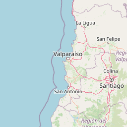
The area encompassed by Río Clarillo National Park lies within the broader cultural landscape of Chile's central valley and Andean foothills, a region with colonial and pre-colonial human presence. The Pirque area, the nearest town to the park, represents the types of rural communities historically associated with the region's agricultural development. While the park itself does not contain significant documented archaeological sites, the protected area exists within a cultural context shaped by centuries of land use and human activity in the Santiago basin.
Top sights and standout views in Río Clarillo National Park
Río Clarillo National Park preserves some of the last remaining Cordilleran cypress forests in central Chile, representing a conservation priority in a region where native vegetation has been extensively modified. The park offers visitors access to Andean foothill landscapes within relatively close proximity to Santiago, making it accessible for day visits and educational excursions. The combination of native conifer forests, riparian corridors, and mountain terrain creates a distinctive natural environment that contrasts with the altered agricultural and urban landscapes surrounding the protected area.
Best time to visit Río Clarillo National Park
The optimal period for visiting Río Clarillo National Park spans the spring and summer months from October through March, when weather conditions in the central Chilean Andes are most favorable for outdoor exploration. Spring brings flowering of native species and Green landscape conditions following the winter rains, while summer offers warm days suitable for trail use. The park is less suitable for visits during the winter months when precipitation is higher and temperatures in the foothill terrain can drop significantly. Autumn provides another window for visits as the weather stabilizes and the landscape transitions toward the dry season.