

Mori Atlas logo
Natural monumentRohožník – lom v Dubči

Examining Ordovician quartzite outcrops and complex tectonic folds in the Prague Plateau landscape

Rohožník – lom v Dubči: An Essential Geological Natural Monument and Protected Area in Prague

Rohožník – lom v Dubči stands as a significant natural monument and protected area located on the outskirts of Prague. This site reveals deep geological history through abandoned quarries that expose durable Řevnice quartzite beds alongside younger Cretaceous strata. The landscape offers a rare, accessible cross-section of ancient sedimentary environments and tectonic deformation, providing a valuable window into the geological anatomy of the wider Prague region.

geological monumentabandoned quarryOrdovician quartzitetectonic foldPrague Plateaunatural monument

Rohožník – lom v Dubči

Natural monument

Park overview

Structured park overview, official facts, and landscape profile for Rohožník, Quarry in Dubeč

Rohožník, Quarry in Dubeč park facts, protected area profile, and essential visitor context

Review the core facts for Rohožník, Quarry in Dubeč, including designation, size, terrain, visitor scale, habitats, and operating context in one park-focused overview.

About Rohožník, Quarry in Dubeč

Rohožník – lom v Dubči sits on the outer eastern edge of Prague, on a low hill called Rohožník along the right bank of the Říčanský potok stream. From a wider geographic perspective, the hill is part of the Pražská plošina, the Prague Plateau, a landscape of gently rolling terrain shaped by ancient sedimentary layers rather than dramatic relief. Two side-by-side abandoned quarries define the protected area, and a narrow buffer strip of additional land links them into a single natural monument.

The defining identity of the park is geological. The hill's backbone consists of rocks from the Liběň formation of the Ordovician period, roughly 450 million years old. Within these rocks, the hardest and most visually prominent layers are the Řevnice quartzites, individual beds of which can reach thicknesses of up to around four meters. These quartzites record a quieter, deeper marine phase of sedimentation, while interbedded clayey shales reflect shifts in the conditions of the Ordovician sea. Above them sit discordantly the Peruc layers, including conglomerates and sandstones interpreted as remnants of ancient freshwater lakes that existed before the region was eventually submerged by the Mesozoic sea. The boundary between these two very different geological worlds, Ordovician and Cretaceous, is one of the central reasons for the site's protected status.

The quarries also preserve textbook evidence of deformation. A clearly visible M-shaped fold in the smaller quarry demonstrates how later tectonic forces bent and folded the rock strata, while the massive quartzite bench in the larger quarry proved more resistant to this squeezing. Quartzite from Rohožník was once widely used to produce the cobblestones that paved large parts of historic Prague, and these stones can still occasionally be found embedded in old streets. Today the quarry is no longer actively worked and serves as an outdoor geological classroom and excursion point.

Ecologically, the open, sun-exposed quarry edges have allowed thermophilous plant communities to establish themselves, while invasive shrubs in the protective zone require ongoing management. The site is a refuge for amphibians and common songbirds in an otherwise heavily used agricultural landscape, and a black pine stand within the buffer zone adds a distinctive planted woodland element.

Quick facts and research context for Rohožník, Quarry in Dubeč

Rohožník – lom v Dubči is a Czech natural monument with IUCN category III designation, located in the Prague 10 administrative district near the village of Dubeč. It lies within the Pražská plošina (Prague Plateau) and forms part of the Říčanka natural park.

The protected area was officially declared on 1 September 1988 and covers approximately 3.37 hectares, comprising two abandoned quarries linked by a narrow protective buffer strip. Its elevation sits around 250 to 270 meters above sea level. The site is registered as natural monument code 1123 in the Czech nature conservation database.

Protection and recognition

Examine documented designation records and international recognition sources for Rohožník – lom v Dubči.

Rohožník – lom v Dubči Protection Status and Terrestrial Conservation Scope

Terrestrial protection records for Rohožník – lom v Dubči outline the documented management scope and conservation framework governing the site. Structured recognition metrics provide clear reference data regarding official designations and administrative context.

Protection details

Protection scope
Terrestrial
Transboundary protection
No
Park context

Deeper park guide and search-rich context for Rohožník, Quarry in Dubeč

Rohožník, Quarry in Dubeč history, landscape, wildlife, and travel context

Explore Rohožník, Quarry in Dubeč through its history, landscape character, ecosystems, wildlife, conservation priorities, cultural context, and seasonal travel timing in a structured park guide built for atlas discovery and search intent.

Why Rohožník, Quarry in Dubeč stands out

Rohožník, lom v Dubči is best known for its exposed Ordovician quartzite beds and the sharp contrast between these ancient Paleozoic rocks and the overlying younger Cretaceous Peruc layers. The site provides a textbook example of how sedimentary environments shifted from a deep, calm Ordovician sea to a later period of tectonic folding, ending with freshwater lake deposits and eventual flooding by the Mesozoic sea. A particularly striking feature is the prominent M-shaped fold in the smaller quarry, which visualizes the intense tectonic forces that deformed the local strata. The thick, resistant quartzite slabs once quarried here were historically used to produce Prague's traditional cobblestones known as kočičí hlavy.
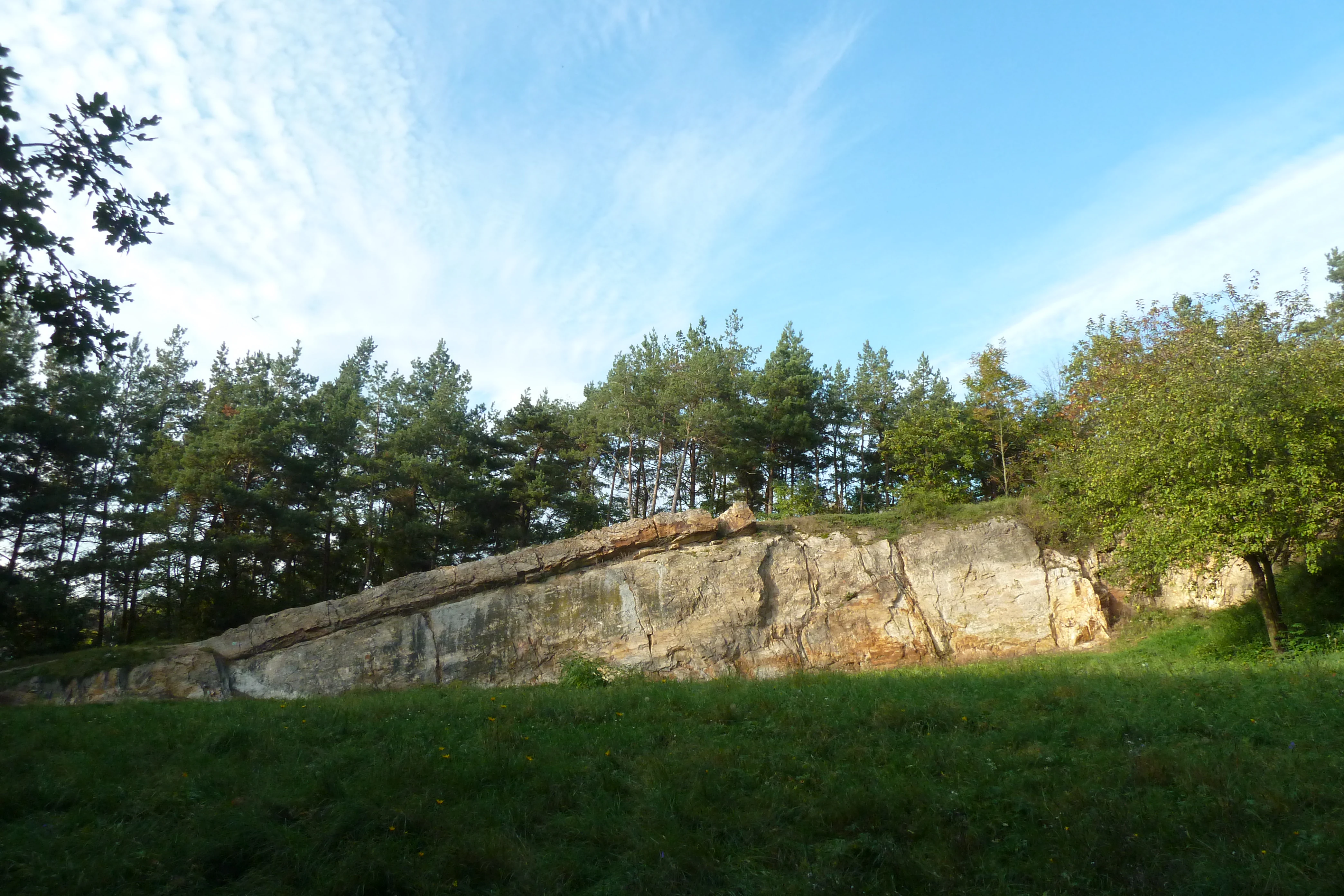
Rohoznik Quarry
A view of the Rohoznik quarry near Dubec

Rohožník, Quarry in Dubeč history and protected-area timeline

The hill now known as Rohožník was originally called Rohozný vrch. The older name is derived from the Old Czech word rohoz, referring to the reeds that once grew in the wetlands surrounding the hill. The presence of such reed-rich surroundings and water sources suggests that the area was already inhabited in distant prehistoric times.

During the 19th and 20th centuries, the hill was mined intensely for its hard quartzite stone, blocks of which were used to produce the cobblestones that historically paved parts of Prague. Archaeological surveys conducted in the 1950s uncovered numerous ceramic fragments associated with itinerant potters, and the findings led to the hill being declared an archaeological cultural monument. This designation likely played a role in halting further excavation and saving at least part of the hill from being completely quarried away.

The archaeological evidence indicates that Rohožník was among the oldest inhabited places in the surrounding region. Settlement at the site appears to have begun during the Eneolithic, the Copper Age, roughly 4000 years BC, and continued intermittently until the early medieval hillfort period. The site is now associated with the documented hilltop settlement known as Výšinné sídliště u Dubečku.

Rohožník, Quarry in Dubeč landscape and geographic character

The landscape of Rohožník – lom v Dubči is defined less by dramatic scenery than by the geological anatomy it reveals. The hill forms a modest ridge rising roughly 20 to 23 meters above its surroundings, with the highest point reaching about 273 meters above sea level. Its slopes are gentle enough to feel like part of the broader Prague Plateau rather than a true mountainous feature, yet the artificial quarry walls and exposed bedrock create sharp, dramatic cross-sections through the underlying geology.

Within the protected area, the terrain alternates between grassy quarry floors, sun-warmed rocky ledges, scree slopes, and patches of planted forest in the buffer zone. South-west-facing slopes are particularly exposed and harbor open plant communities typical of warm, sunny habitats, while more shaded slopes support different vegetation. The narrow buffer strip linking the two quarries adds a subtle connective green corridor that softens the otherwise discrete, cut appearance of the quarry openings.

From a broader regional perspective, the site is embedded in a mosaic of agricultural fields, scattered villages such as Dubeč, Dubeček, Uhříněves, and Klánovice, and the wooded valley of the Říčanský potok stream. The combination of cultivated surroundings and exposed rock walls gives the protected area a quietly distinctive character that is unusual within the otherwise gentle suburban-rural fringe of Prague.

Rohožník, Quarry in Dubeč ecosystems, habitats, and plant life

Rohožník – lom v Dubči has an ecological character shaped strongly by its rocky, sun-exposed terrain and its small fragmented footprint. On the acidic bedrock of the quarry edges, specialized plant communities of rocky edges with acid substrate have established themselves, while the grassy areas preserve remnants of thermophilous, warmth-loving vegetation.

The flora of the site includes a notable mix of grasses and herbs typical of dry, sunny habitats: Koeleria, Salvia, Drepanium, Carex praecox, and Thymus pannonicus are among the recorded species. The most expansive community is dominated by Arrhenatherum elatius, a competitive grass that occupies drier, sunlit slopes, the quarry floor, and even shadier patches. South-west-facing slopes additionally support scree communities featuring Scleranthus perennis, while deeper soils host grasslands with Festuca rupicola and Potentilla argentea. Black pine has been deliberately planted in the protective buffer zone, adding a distinctive Mediterranean-like note to the local vegetation pattern.

A key ecological challenge at the site is the constant pressure from invasive shrubs such as Crataegus, Rosa, Prunus spinosa, and Sambucus. Their encroachment must be actively managed to preserve the open grassland communities. Despite its small size, the site functions as a small semi-natural refuge embedded within the broader agricultural matrix around Prague.

Rohožník, Quarry in Dubeč wildlife and species highlights

The wildlife of Rohožník – lom v Dubči reflects its role as a small refuge island amid intensively farmed countryside. The site is particularly notable for its amphibian fauna. Several species of frogs and toads have been observed here, including the common frog Rana temporaria, the edible frog Pelophylax esculentus, the common toad Bufo bufo, the green toad Bufotes viridis, and the fire-bellied toad Bombina bombina. The combination of quarry pools, moist crevices, and surrounding wet margins makes the site surprisingly suitable for these moisture-dependent species in an otherwise dry agricultural landscape.

The bird community is composed largely of common, adaptable species that thrive in the mosaic of shrubs, open grassland, and tree patches. Nesting species include the collared dove, three species of warblers, leaf warblers, the song thrush, the common blackbird, the European robin, the goldfinch, the chaffinch, buntings, the magpie (Pica pica), and the long-eared owl (Asio otus). Among invertebrates, only typical species of dry pastures are documented, with no rare or specialized fauna emphasized in available records.

The site's small size and disturbed surroundings mean that it is less a wildlife stronghold than a local biodiversity reservoir, providing habitat for species otherwise squeezed out by surrounding agricultural land use.

Rohožník, Quarry in Dubeč conservation status and protection priorities

The conservation significance of Rohožník – lom v Dubči rests on three overlapping dimensions: geology, archaeology, and biodiversity refuge function. Geologically, the protected area preserves a rare and well-exposed contact between Ordovician quartzites of the Liběň formation and the much younger Cretaceous Peruc layers. This contact, together with the visible M-shaped tectonic fold and the thick, easily studied quartzite benches, makes the site a reference locality for understanding the sedimentary and tectonic history of the Prague Basin.

Archaeologically, the surrounding hill contains the documented prehistoric settlement of Výšinné sídliště u Dubečku, with finds stretching as far back as the Eneolithic. The hill's status as an archaeological monument complements its geological protection and has been part of the rationale for limiting further quarrying.

From a biodiversity perspective, the site functions as a small but valuable refuge for amphibians, common songbirds, and thermophilous plant communities in a landscape otherwise dominated by agriculture. Active management is required to control invasive shrubs and to maintain the open character of the species-rich grassland habitats. The protected area is also part of the larger Říčanka natural park, giving it additional landscape-scale conservation context.

Rohožník, Quarry in Dubeč cultural meaning and human context

Rohožník – lom v Dubči carries a layered cultural and historical identity that extends well beyond its formal designation as a natural monument. The hill's original name, Rohozný vrch, ties the place to the wetland reeds that once surrounded it and implies very early human use of the locality. Archaeological surveys in the mid-20th century confirmed that the site was inhabited from at least the Copper Age, with continuous or intermittent occupation stretching into the early medieval hillfort period. The nearby hilltop settlement known as Výšinné sídliště u Dubečku remains an important cultural reference point for the area.

The cultural footprint of the quarry itself is woven into the urban history of Prague. Quartzite extracted at Rohožník shaped the cobblestones, locally known as kočičí hlavy, that paved large stretches of the city's historic streets. Although the pavement of Prague today has largely changed, these stones can still occasionally be encountered in small surviving sections, providing a tangible link between this small protected site and the broader architectural heritage of the Czech capital.

Top sights and standout views in Rohožník, Quarry in Dubeč

Rohožník – lom v Dubči is distinguished by the unusual sharpness of its geological contrasts, the visible M-shaped tectonic fold in the smaller quarry, and the exceptional thickness of its Řevnice quartzite beds. The protected area stands out for combining geological, archaeological, and ecological values in a single compact site on the edge of Prague.

The site also offers a quiet, accessible immersion into the Prague Plateau landscape, with a marked hiking trail passing through and connecting it to the broader Říčanka natural park region.

Best time to visit Rohožník, Quarry in Dubeč

Rohožník – lom v Dubči can be visited meaningfully throughout much of the year, but its character shifts with the seasons. Late spring and early summer bring out the variety of dry-grassland wildflowers on the quarry slopes and make the geological features easiest to appreciate alongside active plant life. Warm, sunny days in this period also offer the best chance of observing reptiles, amphibians near wet micro-habitats, and busy songbird activity around the shrubs and trees.

Autumn tends to highlight the textures and colors of the exposed quartzite walls, with lower vegetation making the rock structures and the famous M-shaped fold more visually prominent. Winter visits, while colder, can also be rewarding for those interested primarily in the geological story, since bare deciduous trees and reduced vegetation open clear sightlines to the quarry faces. The narrow and sometimes uneven terrain suggests comfortable walking shoes in any season, and visitors interested in amphibians or flowering plants will find late spring through early summer most rewarding.

Monthly climate preview

Long-term representative monthly temperature and precipitation patterns

Rohožník – lom v Dubči Climate Normals and Annual Temperature Rhythm

Measured coordinates for Rohožník – lom v Dubči track a continuous annual cycle of shifting monthly temperatures and precipitation rates. Examining the full twelve-month statistical record reveals detailed long-term averages across all seasonal cycles.
Annual mean9 °C
-2 °C20 °C
Jan-2°
Feb-1°
Mar
Apr
May13°
Jun17°
Jul20°
Aug19°
Sep14°
Oct
Nov
Dec-1°
Warmest month
July

19.7 °C

Coolest month
January

-2.2 °C

Wettest month
June

2.6 mm/day

Driest month
February

1.1 mm/day

Park location guide

Geography guide, regional context, and park location map for Rohožník, Quarry in Dubeč

Rohožník, Quarry in Dubeč park geography, regions, and map view in Czechia

Understand where Rohožník, Quarry in Dubeč sits in Czechia through a broader geographic reading of the surrounding landscape, nearby location context, and its mapped position within the national park landscape.

How Rohožník, Quarry in Dubeč fits into Czechia

Czech Republic is a landlocked Central European country with a population of approximately 10.9 million people. The nation was established as an independent state on January 1, 1993, following the dissolution of Czechoslovakia. Its capital and largest city is Prague, with other major urban centers including Brno, Ostrava, Plzeň, and Liberec.

Wider geography shaping Rohožník, Quarry in Dubeč in Czechia

The Czech Republic is a landlocked country in Central Europe. It is bordered by Germany to the west, Austria to the south, Poland to the northeast, and Slovakia to the southeast. The landscape is predominantly hilly, with the territory covering 78,871 square kilometers.

Map view of Rohožník, Quarry in Dubeč

Use this park location map to pinpoint Rohožník, Quarry in Dubeč in Czechia, understand its exact geographic position, and read its mapped placement within the surrounding landscape more clearly.

Pigeon | © OpenStreetMap contributors

Location context for Rohožník, Quarry in Dubeč

Prague

Examining exposed quartzite rock faces, quarry terrain, and protected habitats

Visual Exploration and Landscape Photography of Rohožník – lom v Dubči

Visual records capture the exposed Ordovician quartzite outcrops, abrupt rock faces, and distinct geological folds that define the protected landscape. Examining these field photographs reveals the rugged terrain, dry grassland patches, and unique environmental character of the protected area.

Rohoznik Quarry

Rohoznik Quarry M-fold

Park atlas

Compare adjacent geological monuments and connected regional protected landscapes

Other Parks Near Rohožník – lom v Dubči and Surrounding Regional Protected Areas

Browsing other parks near Rohožník – lom v Dubči reveals a wider network of protected natural areas across the surrounding regional terrain. Comparing adjacent geological formations and local reserves expands your understanding of the broader suburban plateau landscape.
Protected landscapePrague
About 1.3 km away#1 closest

East

Přírodní park Říčanka: Protected Landscape and Geographic Map of Eastern Prague

An analysis of rural corridors, aquatic systems, and forest terrain.

Přírodní park Říčanka preserves an extensive rural ribbon of meadows, arable fields, and woodland patches on the eastern edge of Prague. This structured overview details the park's topography, its historic fishpond chain along the Říčanský potok, and the various natural monuments that characterize this protected Czech landscape.

Area
4 km²
Established
1984
Relief
Lowland
Climate
Temperate
Natural monumentPrague
About 3.8 km away#2 closest

West

Meandry Botiče Natural Monument: Mapped Geography and Protected Stream Landscapes in Prague

Analyzing the ecological boundaries and riparian terrain of the Botič stream corridor

Meandry Botiče represents a significant natural monument in Prague, distinguished by its pronounced stream meanders and dense bankside vegetation. This site offers deep insights into urban conservation, documenting the delicate balance between native riparian flora and the pressures of encroaching residential districts within a managed protected environment.

Area
0.067 km²
Established
1968
IUCN
III
Relief
Lowland
Protected landscapePraha
About 4.9 km away#3 closest

Southwest

Přírodní park Botič-Milíčov: Protected Landscape, River Valley, and Forest Map

A preserved green refuge featuring meandering streams and pond networks near Praha.

Přírodní park Botič-Milíčov stands as a significant protected landscape in Praha, defined by the seasonal flooding of the Botič and Pitkovický streams. The park hosts alluvial forests, a series of historic ponds, and archaeological traces of ancient mills. Through map-based exploration, identify the diverse terrain that includes rocky outcrops at Pitkovická stráň and extensive broadleaf woodlands on the edge of urban housing developments.

Area
8.24 km²
Established
1984
Relief
Lowland
Climate
Temperate
Natural monumentPrague
About 5.1 km away#4 closest

Southwest

Milíčovský les a rybníky: Protected Landscape and Wetland Map in Prague, Czech Republic

Natural monument geography and forest-wetland habitat atlas

Milíčovský les a rybníky represents a core natural monument in southern Prague, featuring a mature deciduous forest integrated with a managed system of ponds. This protected area serves as a critical refuge for rare wetland and woodland species. Use the mapping tools to trace the terrain, from the dense oak-hornbeam canopy to the extensive reedbeds and aquatic environments that define this unique urban-edge landscape.

Area
1.047 km²
Established
1991
IUCN
III
Relief
Upland
Protected landscapePrague
About 5.5 km away#5 closest

West

Hostivař-Záběhlice Nature Park: Protected Landscape and Mapped Prague Geography

River valleys and reservoir terrain within the capital city.

Hostivař-Záběhlice Nature Park represents a vital natural zone in Prague, characterized by the mature forests and meandering river paths along the Botič stream. This record highlights the park's geographic composition, including its reservoirs, lowland forest patches, and its function as a preserved natural corridor within the city.

Area
4.23 km²
Established
1990
Relief
Lowland
Climate
Temperate
Protected landscapeStředočeský kraj
About 8.5 km away#6 closest

East

Přírodní park Škvorecká obora, Králičina: Protected Landscape and Regional Geography

Natural terrain and historic forest near the Prague boundary

Přírodní park Škvorecká obora, Králičina preserves a layered cultural and natural landscape characterized by the Výmola stream floodplain. The area functions as a vital forest habitat on the eastern edge of the Prague Plateau, integrating rare botanical sites with historical remnants of a centuries-old game enclosure.

Established
2009
Relief
Lowland
Climate
Temperate
Access
Easy access
Nature reservePrague
About 11 km away#7 closest

Southwest

V hrobech Nature Reserve: A Protected Botanical Island within the Urban Landscape of Prague

Rare dry-grassland habitats in the Kamýk district

V hrobech is a designated nature reserve in Prague featuring 1.3 hectares of southeast-facing slopes and species-rich grassland. This site is home to rare thermophilic plants and represents an important example of intensive conservation management in an urban environment. Its protected boundaries connect with local forest fragments to maintain ecological value amidst the residential developments of Lhotka and Libuš.

Area
0.013 km²
Established
1988
IUCN
IV
Relief
Lowland
Nature reservePraha 5
About 13 km away#8 closest

West

Prokopské údolí Nature Reserve: Geological Mapping and Protected Area Discovery

A limestone karst landscape situated within the Praha 5 district

Prokopské údolí is an essential protected nature reserve in Praha 5, featuring a deep limestone valley that serves as a globally significant site for Paleozoic fossils and karst geography. This protected landscape encompasses a range of habitats including rock steppes, thermophilic woodlands, and volcanic outcrops, providing a unique look at urban-adjacent nature conservation and historical limestone quarrying within the Czech Republic.

Area
1.71 km²
Established
1978
IUCN
III
Relief
Upland

Common questions about visiting, size, designation, and location context for Rohožník, Quarry in Dubeč

Rohožník, Quarry in Dubeč FAQs for park facts, access, geography, and protected area context

Find quick answers about Rohožník, Quarry in Dubeč, including protected-area facts, park geography, trail and visitor context, and how the park fits into its surrounding country and regional landscape.
MoriAtlas Explorer

Continue Your Protected Areas Search Across the Global Atlas

Deepen your exploration by continuing the structured search for national parks and protected areas worldwide. Utilize the comprehensive filtering capabilities to compare different conservation landscapes and refine your understanding of global park geography. Discover more about the distribution and characteristics of protected natural areas.

Global natural geography