Why Rungkunan National Park stands out
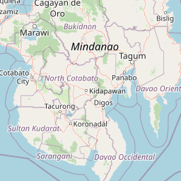
Rungkunan National Park is best known for its role in protecting the Lake Lanao-Agus River Watershed, a critical hydrological system that supports both ecological integrity and human infrastructure in Lanao del Sur. The park's virgin forest stands represent remaining old-growth tropical vegetation in this region of Mindanao, while the area's sparkling streams contribute to the broader watershed function. The park's setting near Lake Lanao places it within one of the largest inland water bodies in the Philippines, adding to its regional significance as a protected area.
Rungkunan National Park history and protected-area timeline
Rungkunan National Park was established on May 5, 1965 through Republic Act No. 4190, which authorized the declaration of various parcels of land as national parks across the Philippines. This legislative action reflected the growing post-war environmental awareness in the country and the recognition that certain landscapes required formal protection to preserve their ecological and watershed values. The specific selection of the Rungkunan area for national park status acknowledged its virgin forest character, its position within the critical Lake Lanao basin, and the stream systems that contributed to downstream water supply. The park's classification as IUCN Category V indicates its intended management approach emphasizes the maintenance of traditional rural landscapes where human activities and nature coexist, rather than strict wilderness preservation. Over the decades, the park has continued under the administrative oversight of the Department of Environment and Natural Resources, though detailed management plan documentation and public access information remain limited compared to more prominent Philippine protected areas.
Rungkunan National Park landscape and geographic character
The terrain of Rungkunan National Park consists primarily of mountainous and hilly landscapes characteristic of eastern Lanao del Sur. The park sits at elevations that contribute to its described invigorating climate, with terrain that channels precipitation through natural stream systems toward the Lake Lanao basin. The area features forest-covered slopes and valleys, with the sparkling streams mentioned in foundational documentation contributing to the visual character of the protected landscape. The regional geography of Lanao del Sur includes the larger Lake Lanao, one of the largest lakes in the Philippines, and the park's position within the lake's watershed places it in an important hydrological role. The landscape supports the conversion of rainfall to groundwater recharge and surface flow that ultimately reaches Lake Lanao, making the park's forest cover functionally significant beyond its visual appeal.
Rungkunan National Park ecosystems, habitats, and plant life
The ecological character of Rungkunan National Park centers on tropical forest ecosystems within the Lake Lanao watershed. The park's virgin forest designation indicates the presence of old-growth tree species that have not been significantly altered by human activity, representing relatively intact ecological communities. These forest areas provide habitat for native species and perform essential watershed functions including soil stabilization, water filtration, and flood regulation. The watershed context is particularly significant given Lake Lanao's role as the source for the Agus River, which powers hydroelectric facilities that supply electricity to Mindanao. The forest ecosystems within the park contribute to maintaining water quality in the broader basin, with tree canopy cover helping to regulate runoff and maintain dry-season base flows in stream systems.
Rungkunan National Park wildlife and species highlights
While the source documentation does not provide detailed species inventories for Rungkunan National Park, the forest and watershed habitats support the biodiversity characteristic of Mindanao's tropical ecosystems. The region's position within the larger Philippines archipelago places it within globally significant biodiversity zones, and forested watersheds such as Rungkunan typically provide habitat for various bird species, small mammals, and invertebrate groups. The proximity to Lake Lanao also creates potential for aquatic and water-associated species in the stream systems that flow through the park. The conservation significance of the area relates to maintaining habitat connectivity within the broader Lanao del Sur landscape, supporting species populations that depend on forest cover and freshwater resources.
Rungkunan National Park conservation status and protection priorities
Rungkunan National Park contributes to Philippine conservation objectives through its protected landscape designation and watershed protection function. The park's inclusion in the national protected areas system, established under Republic Act No. 4190 in 1965, reflects an early recognition of the need to preserve representative examples of Philippine ecosystems. The Lake Lanao-Agus River Watershed Area represents a critical ecological and economic resource for Mindanao, with the watershed's health directly affecting hydroelectric power generation, irrigation for agriculture, and domestic water supply for surrounding communities. Forest protection within the park helps maintain the watershed's functional integrity, reducing erosion, moderating water flow, and protecting water quality. The IUCN Category V classification acknowledges that the landscape supports both conservation values and traditional land use patterns, reflecting a management philosophy that integrates human community needs with environmental protection.
Rungkunan National Park cultural meaning and human context
Rungkunan National Park is situated within Lanao del Sur, a province with deep cultural significance tied to Maranao heritage and the broader Muslim Filipino identity of the region. The park lies near Lake Lanao, which holds religious and cultural importance for Maranao communities surrounding the lake. The municipalities of Ditsaan-Ramain and Tagoloan II, within which the park falls, are part of the traditional territory where Maranao cultural practices and Islamic traditions have shaped the landscape over centuries. While the park's primary designation focuses on natural resource protection, the surrounding cultural landscape includes traditional land management practices and community relationships with the forest and watershed resources. Any future management of the protected area would need to consider the interests and traditional practices of local communities who have historically inhabited the region.
Top sights and standout views in Rungkunan National Park
Rungkunan National Park offers a protected forest experience within the Lake Lanao watershed, one of Mindanao's most significant hydrological systems. The park's established status since 1965 provides long-term conservation framework for its forest ecosystems and stream resources. Its location within relatively close proximity to Marawi City makes it accessible for those interested in exploring the natural landscapes of Lanao del Sur. The protected landscape designation acknowledges the blend of natural values and traditional land use that characterizes this portion of Mindanao.
Best time to visit Rungkunan National Park
The optimal period for visiting Rungkunan National Park would generally correspond to the drier months typically experienced in the Philippines from December through May, when precipitation is reduced and trail conditions are more favorable for forest exploration. The mountainous character of the park means that conditions can vary with elevation, and the invigorating climate referenced in park documentation suggests cooler temperatures compared to lower elevations in the region. Visitors should be aware that conditions in Lanao del Sur can shift based on seasonal weather patterns, and current local guidance should be sought before planning park access. The wet season from June through November may present challenges including trail muddiness and reduced visibility, though forest foliage during this period can offer distinct visual character.