Mori Atlas logo
Nature reserveSägmühle

Mapping the shallow-water habitat and pine-forested terrain between the Igelsbachsee and Kleiner Brombachsee

Sägmühle Nature Reserve: A Detailed Geographic Atlas of the Franconian Lake District Shoreline

(Naturschutzgebiet Sägmühle)

Sägmühle Nature Reserve occupies a distinct position on a narrow landspitze between the Igelsbachsee and the Kleiner Brombachsee in the Middle Franconian region of Bavaria. This protected landscape is defined by an intricate interface of shallow-water zones, silting islands, and sandy-soil pine forest. Through this atlas entry, visualize the reserve's unique configuration as a sanctuary for waterbirds and its role within the engineered lake system designed for regional water management.

nature reserveBavariaMiddle Franconialake shore habitatshallow water zoneislands

Sägmühle

Nature reserve

Park overview

Structured park overview, official facts, and landscape profile for Sägmühle Nature Reserve

Sägmühle Nature Reserve park facts, protected area profile, and essential visitor context

Review the core facts for Sägmühle Nature Reserve, including designation, size, terrain, visitor scale, habitats, and operating context in one park-focused overview.

About Sägmühle Nature Reserve

Sägmühle Nature Reserve occupies a small but ecologically rich corner of the German Lake District, the so-called Fränkisches Seenland, in Middle Franconia. The reserve sits on the narrow land bridge between the Igelsbachsee and the Kleiner Brombachsee, two reservoirs that were created as part of a large-scale water-management project in the late 20th century. When this landscape was reshaped by the construction of the Brombach lakes, areas that were once dry land were submerged, while other shoreline fragments, including the eastern spit where the reserve now lies, survived and gradually developed new natural value as quiet waters, silting zones, and wooded edges returned.

The reserve's defining feature is its shallow-water zone, which forms a complex mosaic with open water, low islands, and developing shoreline habitats in between. The shallow areas, sometimes called Flachwasserzone, are a product of low water depth, gentle slopes, and the absence of strong current; together they create sheltered, food-rich conditions that are particularly valuable for waterbirds. Islands within this zone provide secure nesting sites largely free from terrestrial predators, while the surrounding mainland edges offer forested cover and perching habitat.

Surrounding the lake-fragment sides of the reserve is a pine-dominated forest that reflects the surrounding region's potential natural vegetation on its acidic, sandy soils. This forest is not a planted commercial stand but a relatively close match to what the local landscape would naturally carry, and it plays an important role as the terrestrial complement to the aquatic habitats. The combination of pinewood, shoreline, and shallow water gives the reserve a coherent ecological identity rather than functioning as a single-habitat refuge.

In administrative terms, the Sägmühle Nature Reserve is jointly managed across the districts of Weißenburg-Gunzenhausen and Roth, reflecting the fact that the geological boundary between local jurisdictions runs through this peninsula. It was officially designated in 2000, just after the surrounding Brombach lake system had been completed, allowing conservation authorities to lock in early natural succession that was already underway on these newly exposed shoreline fragments.

For visitors and researchers, the reserve is most meaningful as a bird-focused site. Even though the broader lake landscape is heavily used for recreation, the protected zone offers quiet refuge conditions, and the reserve is regularly referenced among the bird-rich shoreline fragments of the region.

Quick facts and research context for Sägmühle Nature Reserve

Sägmühle Nature Reserve is a designated Naturschutzgebiet in the districts of Weißenburg-Gunzenhausen and Roth in Middle Franconia, Bavaria. It lies about two kilometers east of the town of Absberg, on the eastern landspitze between the Igelsbachsee and the Kleiner Brombachsee, two reservoirs that together form part of the Franconian Lake District.

The reserve was established in the year 2000 and is classified as an IUCN Category IV protected area, reflecting its purpose as a habitat and species management area. The core of the site is an extensive shallow-water zone with islands, fringed by pine forest on nutrient-poor sandy soils. The reserve corresponds to the region's potential natural vegetation and is valued as an important bird breeding and refuge area.

Protection and recognition

Documented conservation status and international recognition data for Sägmühle

Sägmühle Protection Status and Official Designation Records

Examine official protection status records and international designation data compiled for Sägmühle within global protected area databases. Review structured conservation facts and administrative recognition details associated with the natural reserve.

Protection details

WDPA ID
319037
Park context

Deeper park guide and search-rich context for Sägmühle Nature Reserve

Sägmühle Nature Reserve history, landscape, wildlife, and travel context

Explore Sägmühle Nature Reserve through its history, landscape character, ecosystems, wildlife, conservation priorities, cultural context, and seasonal travel timing in a structured park guide built for atlas discovery and search intent.

Why Sägmühle Nature Reserve stands out

Sägmühle Nature Reserve is best known for its shallow-water lakeside habitat: an extensive zone of calm, shallow water interspersed with small islands and developing shoreline vegetation, ringed by pine forest and functioning as both a breeding ground and a refuge for waterbirds. Within the broader artificial lake landscape of the Franconian Lake District, this combination of still water, islands, and sandy-soil pinewood is unusual and ecologically distinctive. The reserve is widely cited as a key example of how intentionally protected shoreline fragments can maintain biodiversity within a heavily engineered water-management system.
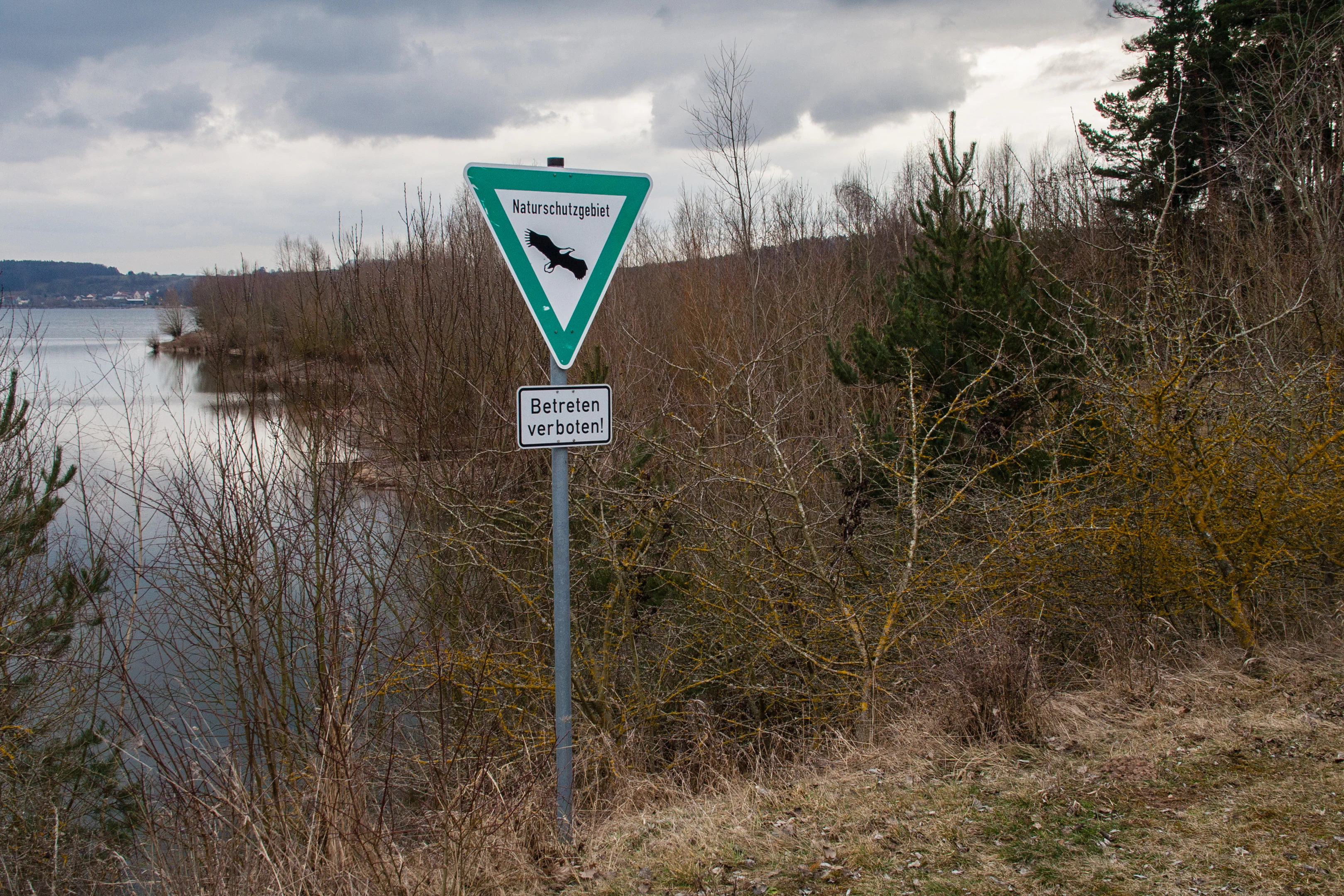
A triangular German nature reserve sign featuring an eagle emblem, mounted on a post beside a shallow lake and shrubbery.
A nature reserve sign at the Sägmühle nature reserve in Bavaria, indicating restricted entry.

Sägmühle Nature Reserve history and protected-area timeline

The protected area called Sägmühle was officially designated in the year 2000, placing its formal history within the later phase of the broader transformation of the Brombach valley into the Franconian Lake District. The lakes themselves, including the Großer Brombachsee, the Kleiner Brombachsee, and the Igelsbachsee, were created as part of a large water-management program designed to address flood control and long-term water supply in northern Bavaria.

The reserve's name preserves the memory of a much older cultural feature: Sägmühle, a sawmill that once stood on the dry land of what is now the bed of the larger Großer Brombachsee. The mill lay roughly 500 meters northeast of the present reserve boundary and was lost when the Brombach valley was flooded to create the reservoir system. Rather than being replaced, the name was kept alive through its application to a nearby surviving shoreline, marking the reserve as both an ecological and a small-memorial site.

By the time the area received formal nature reserve status, the shoreline habitats along the eastern peninsula had already gone through several years of natural development. Quiet shallow margins, small islands, and pine-forested upland had begun to settle into the ecological patterns that the reserve is now recognized for. Designation in 2000 locked in these gains under legal protection and ensured that the area would be managed as a habitat and species area under IUCN Category IV rather than allowed to develop into more intensive recreational lakeshore.

Sägmühle Nature Reserve landscape and geographic character

The physical setting of Sägmühle Nature Reserve is defined by its position on the narrow eastern landspitze between two large reservoir basins. To one side lies the Igelsbachsee, and to the other the Kleiner Brombachsee; between them, the reserve occupies the gentle transition from terrestrial landform to shoreline and shallow water. This geography gives the reserve a long, indented interface between land and water rather than a compact interior.

The visible landscape consists of three concentric zones. Closest to the water lies the extensive shallow-water flat, broken up by small islands and patches of open water. Moving slightly inland, the shallow margins give way to silting and alluvial habitats, where fine sediments accumulate and emergent vegetation can take hold. Further back still, the terrain rises gently into pine-forested upland, whose sandy, nutrient-poor soils influence both the vegetation character and the slow, quiet tone of the area.

The reserve sits at roughly 49.1 degrees north latitude and about 10.9 degrees east longitude, on the southern flanks of the natural feature line that runs through the Brombach lake system. Although the topography is not dramatic, the contrast between the wooded sandy upland and the still, mirror-like waters of the surrounding reservoirs gives the site a calm, reflective character. The underlying soils are characterized as acidic and low in nutrients, which is central to why pine forest, rather than broadleaf woodland, dominates the terrestrial portion of the landscape.

Sägmühle Nature Reserve ecosystems, habitats, and plant life

Ecologically, Sägmühle Nature Reserve functions as a transition zone between aquatic, semi-aquatic, and terrestrial ecosystems on a small scale. Its most distinctive ecological asset is the extensive Flachwasserzone, the shallow-water flat that surrounds and connects the reserve to the broader lake system. Because the water here is shallow, slow-moving, and sheltered, it accumulates organic material and supports dense populations of invertebrates, which in turn support higher trophic levels from fish to birds.

Embedded within this shallow-water flat are several low islands, between which silting habitats have developed. These zones represent one of the most rapidly changing ecological components of the reserve: each year, fine sediments are deposited around the islands, gradually transforming open water into reedbeds, marshy margins, and eventually shrub-covered wetland. This dynamic mosaic of stages of succession is itself a valuable ecological feature, providing habitat diversity at a very small spatial scale.

The terrestrial side of the reserve is dominated by pine woodland on acidic, sandy soils. This is not a planted commercial forest but a relatively natural stand that reflects what botanists call the potential natural vegetation of the region. Because the surrounding landscape has been altered by agriculture, settlement, and reservoir construction, the pinewood at Sägmühle represents an unusually intact example of a habitat type that has largely disappeared elsewhere in the area.

The combination of acidic pinewood on one side and base-rich lake-influenced wetlands on the other creates an unusual ecological contrast within a single protected area, allowing species adapted to very different conditions to coexist within a few hundred meters of each other.

Sägmühle Nature Reserve wildlife and species highlights

Wildlife observation and ecological management efforts at Sägmühle focus overwhelmingly on birdlife, and the reserve is recognized as a habitat and breeding area for numerous bird species. The combination of islands, shallow water, shelter, and adjacent pinewood makes it particularly suited to species that nest on the ground or among low vegetation near water and rely on quiet surroundings.

Waterbirds benefit from the shallow-water flats and islands, which provide both feeding habitat and safe nesting sites largely free from mammalian predators. Reed-fringed silting zones offer cover for secretive species, while open water nearby is used by diving and swimming birds that depend on the larger Brombach lake system but retreat into the reserve area when disturbed.

The pinewood surroundings and the wooded edge of the reserve support conifer-adapted songbirds and other woodland species. Branches and trunks along the shoreline serve as perches, song posts, and roosting sites, and the relatively undisturbed nature of the forest gives these species a quieter alternative to the busier recreational lakeshore further along the lake system.

While the reserve is not typically cited as a major mammal or reptile site, the diversity of structural habitats within a small area means that species associated with sandy, dry pine forest, with wetland edges, and with open water can each find suitable conditions. The reserve's ecological importance to wildlife lies less in hosting rare individual species than in maintaining the habitat mosaic these species need across the year.

Sägmühle Nature Reserve conservation status and protection priorities

From a conservation perspective, Sägmühle Nature Reserve is a small but strategically placed fragment within a heavily engineered water landscape. The Brombach lake system was created primarily for hydrological and recreational purposes, and the reserve exists to ensure that within this modified environment, some shoreline remains undisturbed and ecologically functional.

The site is classified as an IUCN Category IV protected area, a Habitat/Species Management Area, indicating that its principal aim is active conservation of habitats and species rather than strict wilderness preservation. In practice, this means the reserve is managed to maintain the shallow-water flats, islands, and pinewood, while allowing natural silting and successional processes to continue shaping the landscape.

The reserve also plays a coordination role within the wider network of protected shoreline in the region. It sits alongside other small reserves such as the Halbinsel im Kleinen Brombachsee and the Stauwurzel des Igelsbachsees, which together form a chain of protected sites around the larger Brombach complex. Maintaining this chain is one of the main conservation rationales, because each individual fragment by itself would be too small and isolated to sustain viable populations of many species over the long term.

The pinewood component of the reserve adds another conservation value: on acidic, sandy soils, pine forests close to potential natural vegetation are now rare in central Europe. Preserving a representative example of this habitat in a region otherwise dominated by agricultural land, reservoir water, and settlement gives the reserve a habitat-conservation significance that extends beyond its small footprint.

Sägmühle Nature Reserve cultural meaning and human context

The cultural layer around Sägmühle Nature Reserve is modest but meaningful. The name itself preserves a piece of pre-reservoir history: the Sägmühle, a sawmill that once operated in the Brombach valley before the area was flooded to create the Großer Brombachsee. Sites like this were traditionally named after the mills and other small rural industrial features that defined the local economy in earlier centuries, and the survival of the name in the protected area's designation is a small reminder of the valley's pre-modern character.

The reserve sits within a landscape that has been deliberately reshaped by modern infrastructure, including the Brombach reservoir system and the corresponding flood-control and water-supply programs. This juxtaposition of modern water engineering and pre-existing rural and natural place names is part of what gives the region its distinctive sense of layered history: visitors encounter a landscape whose visible form is largely 20th-century and whose cultural memory, including the Sägmühle name, is much older.

Local administrative identity also plays a role. The reserve spans the boundary between the districts of Weißenburg-Gunzenhausen and Roth, which means it is stewarded collaboratively by neighboring local authorities rather than being confined to a single municipal or county tradition.

Top sights and standout views in Sägmühle Nature Reserve

Sägmühle Nature Reserve's standout features converge on its position between two lakes and on the unusual coexistence of acidic pinewood, shallow water, and silting islands within a single small site. The reserve offers both a quiet refuge for waterbirds and a small but intact example of sandy-soil pine forest close to the natural potential vegetation of the region.

Best time to visit Sägmühle Nature Reserve

The reserve is most interesting during the warmer months of the year, when bird activity along the shoreline is at its peak and the shallow-water flats support the highest diversity of waterbird life. Spring and early summer tend to be the most rewarding seasons for observing breeding behavior around the islands and reed-fringed silting zones, while early morning and evening visits generally offer the most active wildlife viewing regardless of season. Because the reserve's habitats are largely water-based and quiet, visits during the warmer, drier parts of the year are also more comfortable for walking along viewing areas in the surrounding lake landscape, though the reserve itself remains best appreciated as a quiet, contemplative site rather than a destination for active recreation.


Monthly climate preview

Long-term temperature and monthly precipitation patterns across representative coordinates

Sägmühle Climate Normals and Annual Weather by Month

Sägmühle records measured average temperatures from subzero winter minima to warm summer maximums alongside consistent daily precipitation rates. Examining the full twelve-month profile provides complete historical climate data for this protected area.
Annual mean8 °C
-1 °C18 °C
Jan-1°
Feb
Mar
Apr
May13°
Jun16°
Jul18°
Aug18°
Sep14°
Oct
Nov
Dec
Warmest month
July

18.4 °C

Coolest month
January

-1.3 °C

Wettest month
July

2.9 mm/day

Driest month
February

1.5 mm/day

Park location guide

Geography guide, regional context, and park location map for Sägmühle Nature Reserve

Sägmühle Nature Reserve park geography, regions, and map view in Germany

Understand where Sägmühle Nature Reserve sits in Germany through a broader geographic reading of the surrounding landscape, nearby location context, and its mapped position within the national park landscape.

How Sägmühle Nature Reserve fits into Germany

Germany is a federal republic in Western and Central Europe with a population of over 83 million across sixteen constituent states. It is Europe's largest economy by nominal GDP and a major global exporter and importer. The capital is Berlin, and the country borders Denmark, Poland, Czech Republic, Austria, Switzerland, France, Luxembourg, Belgium, and the Netherlands.

Wider geography shaping Sägmühle Nature Reserve in Germany

Germany is located in Western and Central Europe, spanning 357,022 km². It borders Denmark to the north, Poland and the Czech Republic to the east, Austria and Switzerland to the south, and France, Luxembourg, Belgium, and the Netherlands to the west. The country has coastlines on the Baltic Sea and North Sea to the north, with the Alps located in the southern region.

Map view of Sägmühle Nature Reserve

Use this park location map to pinpoint Sägmühle Nature Reserve in Germany, understand its exact geographic position, and read its mapped placement within the surrounding landscape more clearly.

Pigeon | © OpenStreetMap contributors

Location context for Sägmühle Nature Reserve

Bavaria

Explore detailed visual records of the shallow water zone, islands, and pine forests.

Sägmühle Landscape and Scenery Photography: Visualizing the Protected Shoreline

Visual documentation reveals the distinct topography and habitat mosaics that define the protected shoreline environments. Examining field photography offers a clearer understanding of the terrain, vegetation patterns, and ecological character unique to the reserve.

A triangular German nature reserve sign featuring an eagle emblem, mounted on a post beside a shallow lake and shrubbery.

Park atlas

Compare adjacent lake shore habitats and regional nature reserves across Middle Franconia.

Parks Near Sägmühle and Surrounding Protected Landscapes to Explore Next

Browse other protected areas near Sägmühle to discover connected shoreline habitats and wetland reserves across the Brombach lake system. Comparing adjacent reserves reveals the broader ecological network sustaining waterbird sanctuaries throughout Bavaria.
Nature reserveWeißenburg-Gunzenhausen
About 19 km away#1 closest

South

Schambachried: Protected Calcareous Fen and Wetland Geography in Weißenburg-Gunzenhausen

Historic nature reserve marking the karst and valley transition

Schambachried preserves a rare calcareous lowland fen within the Treuchtlingen Pforte of Bavaria. As the oldest nature reserve in Middle Franconia, this protected area offers a concentrated study of botanical diversity at the meeting point of the Weißenburger Alb limestone plateau and the Schambach valley stream system.

Area
0.069 km²
Established
1973
IUCN
IV
Relief
Lowland
A soft watercolor illustration of rolling hills and gentle terrain in shades of pale green and muted earth tones against a white background.
Protected landscapeMittelfranken
About 28 km away#2 closest

Northwest

Naturpark Frankenhöhe Protected Landscape: Geography, Map, and Regional Conservation Context

Explore the diverse natural terrain of the Mittelfranken region in Bavaria.

Naturpark Frankenhöhe serves as a significant protected landscape in western Mittelfranken, encompassing a unique mosaic of forests, vineyards, and agricultural valleys. This geographic entity is shaped by the European Main Watershed, where rivers divide between the Rhine and Danube systems. Its terrain provides a study in transitions, from higher forested crests to open orchard meadows that define the local Bavarian countryside.

Area
1,104.06 km²
Established
1974
Relief
Mixed relief
Climate
Temperate
A horizontal watercolor illustration of a natural landscape showing sandy ground, patches of green vegetation, a small pond, and a distant treeline against a pale sky.
Nature reserveNuremberg
About 30 km away#3 closest

Northeast

Sandgruben am Föhrenbuck Nature Reserve: Geography and Protected Area Overview in Nuremberg

A compact mosaic of restored quarry habitats and forest terrain in Bavaria.

Sandgruben am Föhrenbuck stands as a notable protected area in Nuremberg, Germany, defined by its dense concentration of varied ecosystems including wetlands, dry heath, and open sand. This former industrial site demonstrates how active management can foster diverse habitats, providing a rich area for studying land restoration and regional biodiversity within a forest-framed setting.

Area
0.219 km²
Established
1992
IUCN
IV
A soft, light-toned watercolor illustration of a river landscape with rolling hills in the background and a lone tree in the foreground.
Nature reserveBavaria
About 33 km away#4 closest

Northeast

Schwarzachschlucht Nature Reserve: Geographic Map and Protected Landscape Overview in Bavaria

A study of Franconian sandstone topography and riverine protected habitats

Schwarzachschlucht provides a focused example of geological erosion and forest conservation in Bavaria. This nature reserve features distinctive honeycomb-weathered cliffs, deep river-carved channels, and a significant moss-rich microclimate that has been protected since 1936. The site serves as a vital case for observing the transition between mixed forest slopes and alder-lined riverbanks within the Nürnberger Land district.

Area
0.38 km²
Established
1936
IUCN
IV
Relief
Upland
A pale, soft-toned watercolor painting showing a wetland scene with grass, trees, and distant hills.
Nature reserveNürnberger Land
About 34 km away#5 closest

Northeast

Schwarzenbrucker Moor Nature Reserve: Geography and Protected Wetland Boundaries

A rare peatland habitat in the Middle Franconian landscape.

Schwarzenbrucker Moor is a preserved wetland complex situated within a bowl shaped former river meander. This nature reserve sustains a dense mosaic of open water, reedbeds, and alder bog woodland. Examine the site geography, mapped boundaries, and environmental significance of this protected habitat within the Nürnberger Land district.

Area
0.1 km²
Established
1992
IUCN
IV
Relief
Lowland
Nature reserveLandkreis Eichstätt
About 39 km away#6 closest

South

Naturwaldreservat Tucherwald: Protected Karst Forest Landscape in Landkreis Eichstätt

A study in non-intervention woodland and natural forest dynamics

Naturwaldreservat Tucherwald preserves a diverse mosaic of beech, oak, and linden forest on the steep, limestone slopes of the southern Frankenalb. This protected area offers insight into unmanaged forest succession, standing deadwood habitats, and the unique microclimates found within the Wellheim Dry Valley regional geography.

Area
0.541 km²
Established
1998
Relief
Upland
Scope
Terrestrial
A horizontal watercolor illustration depicting a soft, pastel landscape with rolling hills in the background, a small pond, and several green and light pink flowering trees.
Nature reserveBaden-Württemberg
About 51 km away#7 closest

West

Crailsheimer Hart und Reusenberg: Protected Nature Reserve and Karst Landscape Geography

Jagst valley protected habitat in Baden-Württemberg

Crailsheimer Hart und Reusenberg represents a key conservation unit in southwest Germany. This nature reserve is recognized for its distinctive gypsum keuper geology, which creates a network of dolines, semi-dry grasslands, and near-natural floodplain forests. Understanding its boundaries provides insight into habitat connectivity within the broader Baden-Württemberg protected-area network.

Area
7.14 km²
Established
2019
A soft watercolor painting of a winding river flowing through green rolling hills and meadows under a hazy, bright sky.
Protected landscapeBavaria
About 52 km away#8 closest

Northeast

Naturpark Fränkische Schweiz, Frankenjura: An Atlas of Bavarian Karst and Forested Landscapes

Protected landscape geography within the northern Franconian Jura.

Naturpark Fränkische Schweiz, Frankenjura is a landmark protected area covering over 2,300 square kilometers across Bavaria. Its terrain is defined by a rhythmic sequence of limestone plateaux, winding river valleys, and dolomite formations, balanced by the quieter, pine-dominated reaches of the Veldensteiner Forst. This atlas entry details the park's geological complexity and its significant role in regional conservation.

Area
2,335.44 km²
Established
1968
Relief
Upland
Climate
Temperate

Common questions about visiting, size, designation, and location context for Sägmühle Nature Reserve

Sägmühle Nature Reserve FAQs for park facts, access, geography, and protected area context

Find quick answers about Sägmühle Nature Reserve, including protected-area facts, park geography, trail and visitor context, and how the park fits into its surrounding country and regional landscape.
MoriAtlas Explorer

Continue Your Protected Areas Search Across the Global Atlas

Deepen your exploration by continuing the structured search for national parks and protected areas worldwide. Utilize the comprehensive filtering capabilities to compare different conservation landscapes and refine your understanding of global park geography. Discover more about the distribution and characteristics of protected natural areas.

Global natural geography