Why Salmon, Challis National Forest stands out
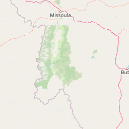
Salmon, Challis National Forest is best known for housing the bulk of the Frank Church, River of No Return Wilderness, the largest wilderness area in the contiguous United States. The forest is equally associated with the upper Salmon River corridor, where the Wild and Scenic Salmon River threads through the Sawtooth Mountains over a stretch of more than 75 miles. It is also recognized for containing Borah Peak and the surrounding Lost River Range, which give the forest some of the highest and most rugged terrain in Idaho. Together, these river and mountain systems make Salmon, Challis a defining landscape of central Idaho's wild country.
Salmon, Challis National Forest history and protected-area timeline
Salmon–Challis National Forest was formally established on July 1, 1908, through the administrative union of the earlier Salmon and Challis national forests in central Idaho. These predate-era reserves were products of the early federal conservation movement in the American West, when forest reserves were set aside under the U.S. Forest Service and its predecessor bodies to protect watersheds, timber, and game habitat from unregulated use.
The modern, combined forest reflects a long-term evolution in federal land management, in which two originally separate forest units were administered together to streamline grazing, timber, fire, and recreation programs across a large and geographically continuous landscape. Over time, the forest's significance grew beyond its original utilitarian conservation role as large tracts within it were designated as wilderness under the National Wilderness Preservation System, beginning with the Salmon River Breaks Primitive Area and culminating in the 1980 designation of the River of No Return Wilderness, later renamed the Frank Church–River of No Return Wilderness in honor of the Idaho senator who championed wilderness protection.
The forest's history is also intertwined with the rural communities of east central Idaho, particularly the town of Salmon, which serves as the location of the combined forest headquarters. Ranger district offices in Challis, Clayton, Mackay, Leadore, North Fork, and Salmon reflect the long-standing role of the forest as an economic and cultural anchor for surrounding ranching and mining communities, even as its protected wilderness acres have grown over the decades.
Salmon, Challis National Forest landscape and geographic character
Salmon–Challis National Forest occupies a rugged, mountainous region of east central Idaho, with terrain that ranges from deep river canyons to high alpine ridges. The northern part of the forest lies within and around the Sawtooth Range, a jagged spine of granite peaks, glaciated cirques, and forested valleys that frame the headwaters and upper reaches of the Salmon River. The river here drops through narrow channels, with long stretches of whitewater and cliff-walled canyons that make the corridor one of the most striking river landscapes in the lower 48 states.
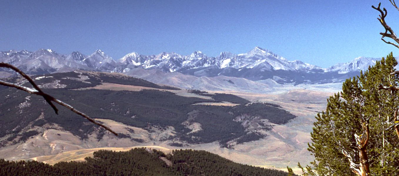
To the south, the Lost River Range introduces an even higher and harsher alpine environment. Borah Peak, Idaho's tallest mountain, anchors this range and gives the southern portion of the forest dramatic vertical relief, with barren ridges, talus slopes, and high basins above timberline. Between these two mountain systems lie broad valleys, sage-covered foothills, and rolling forested country through which the Salmon River and its tributaries, including the Big Lost River, meander before the rivers break into deeper canyons.
The forest's river geography is just as defining as its mountains. The Wild and Scenic Salmon River flows for more than 75 miles within the forest, while the Big Lost River has its headwaters within this protected landscape. Together, these river valleys, ridges, and peaks create a checkerboard of habitats shaped by elevation, aspect, and water availability, producing a varied scenery that is unmistakably central Idaho.
Salmon, Challis National Forest ecosystems, habitats, and plant life
Salmon–Challis National Forest spans a wide spectrum of ecological zones, from sagebrush-dominated foothills and high desert steppe to dense coniferous forests on mountain slopes and sparse alpine vegetation near the summits of the Lost River and Sawtooth ranges. Lower elevations often carry stands of Douglas fir, lodgepole pine, and juniper, while higher slopes transition into spruce, subalpine fir, and open parkland, eventually giving way to rocky tundra near the summits.
Watersheds are a defining ecological feature. The Salmon River and its tributaries support extensive riparian vegetation along their banks, with cottonwoods, willows, and alders forming dense, narrow corridors through otherwise dry country. The Big Lost River and other Lost River streams originate within the forest and contribute to local wetlands and meadows that increase habitat diversity in an otherwise arid landscape.
A significant portion of the forest's ecological value lies in its wilderness. The Frank Church–River of No Return Wilderness, which falls mostly within Salmon–Challis, holds some of the most intact and least disturbed vegetation in the contiguous United States, with old-growth forest stands, native shrublands, and natural fire regimes still operating across large areas. The portions of the Sawtooth Wilderness and the Jim McClure–Jerry Peak Wilderness within the forest add to this ecological continuity.
Salmon, Challis National Forest wildlife and species highlights
The varied river, forest, and alpine environments of Salmon–Challis National Forest support a rich vertebrate fauna typical of central Idaho. Large and mid-sized mammals such as elk, mule deer, moose, black bear, and mountain lion are present across the forest, particularly in meadow, forest edge, and wilderness habitats. Mountain goats are found in the high cliffs of the Lost River Range, while bighorn sheep occupy some of the more rugged rocky terrain in the south.
The Salmon River and its tributaries provide strong habitat for native fish, including Chinook salmon and steelhead, which use the long, undammed main Salmon as one of the most important migration corridors in the interior Pacific Northwest. Cutthroat trout and bull trout populate colder tributary streams and headwaters, and the Big Lost River and its forks contribute additional cold-water habitat within the forest.
The forest's birdlife reflects both its elevation range and the extensive wilderness. Raptors such as golden eagles nest on cliffs in the higher country, while songbirds, woodpeckers, and grouse occupy the forested slopes and meadows. Bald eagles and other fish-eating birds are associated with the river corridors. Because much of the wildlife habitat lies within or adjacent to large designated wilderness, animal populations here benefit from some of the lowest levels of human development in the lower 48 states.
Salmon, Challis National Forest conservation status and protection priorities
Salmon–Challis National Forest plays a major role in conservation in the northern Rockies because of its sheer scale and the large share of wilderness it contains. Most of the Frank Church–River of No Return Wilderness, the largest designated wilderness south of Alaska, is administered through this forest, giving the area a level of ecological protection that is rare in the contiguous United States. This wilderness protects not only forest ecosystems but also one of the longest undammed river corridors in the lower 48 states.
Conservation significance extends beyond wilderness designation. The forest safeguards major portions of the upper Salmon River watershed, including headwaters, tributaries, and floodplains that are critical for native salmon, steelhead, and resident trout populations. The Wild and Scenic designation of the Salmon River, which runs more than 75 miles through the forest, reinforces its protected status and limits water resource development along the corridor.
The forest also contributes to broader landscape connectivity in central Idaho. Its lands adjoin or are interspersed with other national forests, Bureau of Land Management holdings, and the Sawtooth National Recreation Area, which together form one of the largest contiguous blocks of public land in the contiguous United States. This connectivity supports migratory wildlife, native fish populations, and ecological processes that depend on large, intact landscapes, including natural fire regimes that continue to shape the vegetation of the region.
Salmon, Challis National Forest cultural meaning and human context
The landscape of Salmon–Challis National Forest is closely tied to the rural and ranching heritage of east central Idaho. Small communities such as Salmon, Challis, Leadore, North Fork, Clayton, and Mackay have long histories tied to livestock grazing, mining, and outfitting, and the forest remains an important economic and cultural anchor for these towns. The forest headquarters in Salmon reflect this long-standing relationship.
The remote and rugged character of the area also links the region to a tradition of backcountry recreation and river running. The Salmon River corridor, with more than 75 miles flowing through the forest, has become one of the iconic river-running landscapes in the American West. At the same time, the surrounding mountains carry the imprint of historic mining districts and early sheep and cattle operations, contributing to a layered sense of human history across an otherwise wild landscape.
Top sights and standout views in Salmon, Challis National Forest
Salmon–Challis National Forest stands out for its exceptional size, with more than 4.2 million acres of continuous national forest land in east central Idaho. It contains most of the Frank Church–River of No Return Wilderness, the largest wilderness in the contiguous United States, and includes Borah Peak, the highest point in Idaho, within the dramatic Lost River Range.
Equally distinctive is its river landscape. The Wild and Scenic Salmon River flows for more than 75 miles through the forest, threading between the Sawtooth and Lost River ranges and creating one of the longest undammed river corridors in the lower 48 states. Together with the Sawtooth National Recreation Area and adjacent national forests, Salmon–Challis anchors one of the largest and most ecologically intact blocks of public land in America.
Best time to visit Salmon, Challis National Forest
Summer is the most accessible and popular season in Salmon–Challis National Forest, when the higher mountain trails, river access points, and ranger district roads are largely free of snow. Late spring through early fall is also when the Salmon River's float season is at its peak and when alpine wildflower blooms color the higher meadows. Wildlife viewing for elk, deer, and other species is generally best in the cooler dawn and dusk hours across this broader window.
Winter brings deep snow to much of the forest, particularly at higher elevations such as the Lost River Range, but it also opens up snowmobiling and backcountry skiing opportunities in select areas and produces a striking, quiet alpine scenery. Shoulder seasons such as late spring and early autumn can feature fewer visitors and shifting landscapes, from fresh snowmelt to early snow dustings on the peaks, though access to remote backcountry areas may be limited by road conditions.