
Mori Atlas logo
Nature reserveSchwarzbachtal bei Götzenberg

Analyzing the mapped boundaries and natural terrain of this river valley ecosystem

Schwarzbachtal bei Götzenberg: Geographic Atlas of a Protected Nature Reserve in Germany

(Naturschutzgebiet Schwarzbachtal bei Götzenberg)

Schwarzbachtal bei Götzenberg represents a significant protected nature reserve situated within the Mettmann district of North Rhine-Westphalia. The landscape is defined by the near-natural course of the Schwarzbach stream, creating a complex mosaic of damp grasslands, floodplain forests, and spring-fed wetlands. This site serves as a vital ecological corridor, showcasing the interplay between old-growth beech woodlands and riparian zones within a densely populated German region.

stream valleyfloodplain forestbeech forestwet grasslandreedbedsspring areas
A flat-design, digital illustration showing a meandering river flowing through a lush green valley toward a large, craggy cliff face under a soft sky.

Schwarzbachtal bei Götzenberg

Nature reserve

Park overview

Structured park overview, official facts, and landscape profile for Schwarzbachtal bei Götzenberg

Schwarzbachtal bei Götzenberg park facts, protected area profile, and essential visitor context

Review the core facts for Schwarzbachtal bei Götzenberg, including designation, size, terrain, visitor scale, habitats, and operating context in one park-focused overview.

About Schwarzbachtal bei Götzenberg

Schwarzbachtal bei Götzenberg is a small but ecologically dense nature reserve situated in the southern outskirts of Ratingen, in the Mettmann district of North Rhine-Westphalia. Although the reserve occupies only around 54 hectares and lies in close proximity to major transport infrastructure, including the A3 autobahn, it preserves a remarkably coherent valley landscape centered on the Schwarzbach. The protected area consists of three separate parcels that together encompass the central section of the Schwarzbach valley, together with adjoining slopes and tributary feeders.

The reserve belongs to the broader network of protected areas in the Bergisches Land, an area traditionally known for its wooded valleys and dispersed settlement. Within that regional context, the Götzenberg section of the Schwarzbach stands out because its stream retains a near-natural course through almost its entire protected length, with associated natural spring zones, side tributaries, and intact riparian vegetation. Surrounding land use includes two golf courses on either side of the valley, which makes the refuge role of the protected area particularly significant for local biodiversity.

Ecologically, the site is defined by a layered habitat mosaic. In the narrow floodplain of the Schwarzbach, ash and alder floodplain forests dominate and form the core riparian habitat. On the slopes and higher areas, Luzula beech forest (Hainsimsen-Buchenwald) and mixed deciduous woodland contribute old-growth qualities and the deadwood element that supports saproxylic species. Damp meadows, abandoned grassland encroaching on reed, and small ponds link the forest patches to the open valley floor, creating transitional habitats that host a wide range of plant and animal species.

The reserve is managed by the lower landscape authority of the Mettmann district and is embedded in the framework of the district's landscape plan, which was updated to incorporate the site in 2012. Its protection goals combine classic habitat conservation with active restoration, including the gradual replacement of non-native hybrid poplars on floodplain sites, the reintroduction of small open-water bodies, control of invasive giant hogweed, and the continued maintenance of wet grassland against succession by reed and scrub.

Quick facts and research context for Schwarzbachtal bei Götzenberg

Schwarzbachtal bei Götzenberg is a nature reserve in Ratingen, Mettmann district, North Rhine-Westphalia, Germany, classified as an IUCN Category IV Habitat/Species Management Area. The reserve covers approximately 53.9 hectares and carries the official identifier ME-011 within the protected-area system of the Mettmann district.

It consists of three separate sections that flank a central stretch of the Schwarzbach stream, where the watercourse retains a near-natural character over most of its length. The reserve was established in 1984 and was updated through the landscape plan of the Mettmann district in 2012. It is administered by the lower landscape authority (Untere Landschaftsbehörde) of the Mettmann district.

Protection and recognition

Examine documented terrestrial conservation frameworks and official records for Schwarzbachtal bei Götzenberg.

Schwarzbachtal bei Götzenberg Protection Status and Mapped Designation Record

Schwarzbachtal bei Götzenberg features a documented terrestrial protection status within official conservation datasets. Conservation analysts can review specific management parameters, designation records, and verified recognition sources for this protected area.

Protection details

Protection scope
Terrestrial
Transboundary protection
No
WDPA ID
165494
Park context

Deeper park guide and search-rich context for Schwarzbachtal bei Götzenberg

Schwarzbachtal bei Götzenberg history, landscape, wildlife, and travel context

Explore Schwarzbachtal bei Götzenberg through its history, landscape character, ecosystems, wildlife, conservation priorities, cultural context, and seasonal travel timing in a structured park guide built for atlas discovery and search intent.

Why Schwarzbachtal bei Götzenberg stands out

Schwarzbachtal bei Götzenberg is best known for its near-natural stretch of the Schwarzbach stream and the unusually intact mosaic of habitats that surround it in an otherwise heavily settled landscape. Old-growth beech forest with large amounts of standing and lying deadwood is one of the defining features, along with ash and alder floodplain forest (Auenwald) in the narrow riparian corridor, damp meadows, reedbeds, small ponds, and spring-fed wet woodland. The reserve is also recognized for its importance to wetland-dependent and stream-associated wildlife. It supports breeding birds such as Eurasian reed warbler, sedge warbler, yellowhammer, reed bunting, grey wagtail, and white-throated dipper, while the kingfisher uses the area as a feeding territory. Amphibians and reptiles, particularly the grass snake, are considered important elements of the site's fauna. Together, these qualities make the valley a notable example of small-scale but ecologically rich stream-valley conservation in the Bergisches Land region.
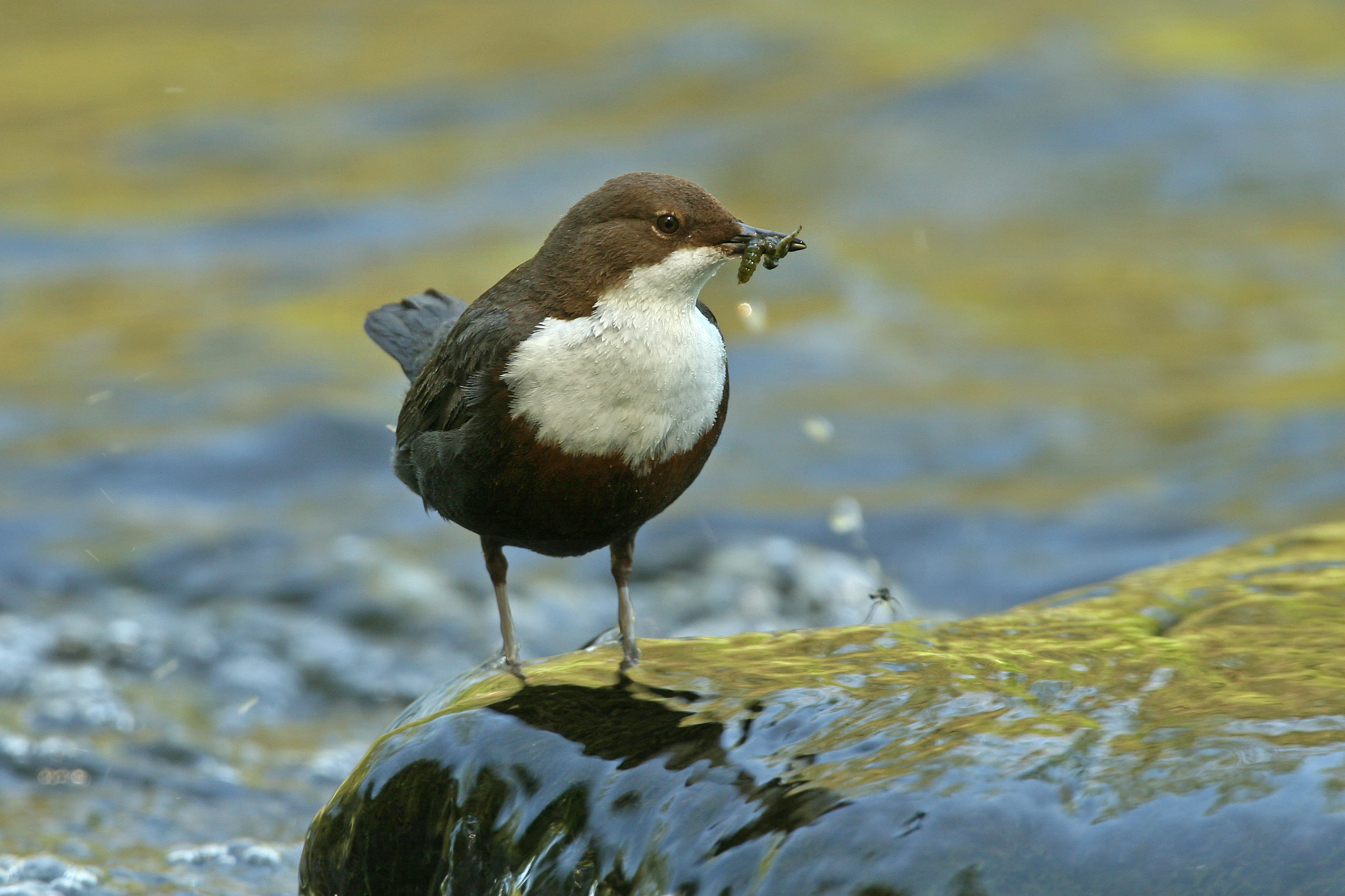
A white-throated dipper with a dark brown body and a prominent white chest patch stands on a wet, mossy rock in a stream, carrying a small insect in its beak.
A white-throated dipper, characteristic of the streams in the nature reserve, perched on a rock with food in its beak.

Schwarzbachtal bei Götzenberg history and protected-area timeline

The area now known as Schwarzbachtal bei Götzenberg was placed under formal nature protection in 1984 under the identification number ME-011 within the Mettmann district's protected-area system. This initial designation recognized the site's existing ecological value, particularly the near-natural condition of the Schwarzbach and the integrity of the surrounding beech and floodplain forest.

In 2012, the reserve was incorporated into the updated landscape plan (Landschaftsplan) of the Mettmann district, which formalized current management priorities and protection objectives. The updated framework explicitly addresses the conversion of hybrid poplar stands into site-appropriate woodland, the maintenance of open wet grassland and reedbeds, the protection of spring zones, and the renaturation of still-altered stream sections. The reserve has thus evolved from a single-purpose 1984 designation into a more actively managed ecological restoration site embedded in regional planning.

Schwarzbachtal bei Götzenberg landscape and geographic character

The landscape of Schwarzbachtal bei Götzenberg is shaped by a single defining feature: the valley of the Schwarzbach, which cuts southeastward through the area southeast of Ratingen's town center. The reserve occupies both sides of this valley and includes sections on either side of the A3 autobahn, which passes through the area. The valley floor is narrow and dominated by riparian vegetation, while the surrounding slopes rise into mixed deciduous and beech woodland.

The stream itself is the heart of the landscape. Along most of its protected length, it retains a near-natural course, with meanders, varied banks, and a shallow, structured channel. Natural springs feed both the main stream and the side tributaries, producing soggy floodplain areas and small open water bodies that punctuate the valley floor. The broader setting includes two adjoining golf courses, the Grevenmühle Golf Club to the east and the Düsseldorfer Golf Club to the northwest, which frame the reserve within a larger mosaic of intensively used and protected land.

Viewed as a whole, the protected area reads as a green wedge running through an otherwise built-up and heavily trafficked suburban margin of Ratingen. The contrast between the enclosed forest, the lush floodplain, and the surrounding urban and recreational land use is one of the defining landscape characteristics of the site.
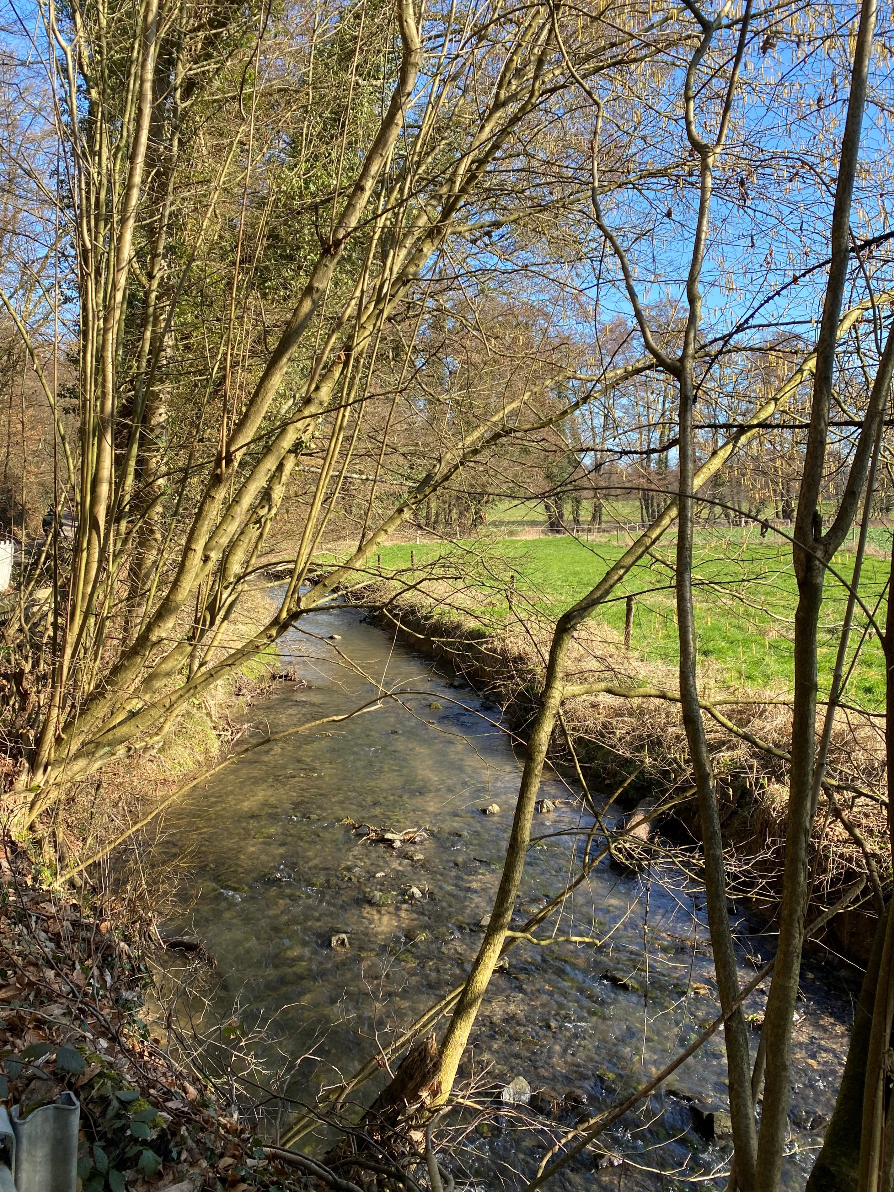
A small stream flows through a grassy meadow bordered by thin, bare-branched trees under a bright blue sky.
The Schwarzbach stream flowing through the valley of the Schwarzbachtal bei Götzenberg nature reserve.

Schwarzbachtal bei Götzenberg ecosystems, habitats, and plant life

Ecologically, Schwarzbachtal bei Götzenberg is best understood as a small, layered floodplain-and-forest complex. The reserve protects an unusually complete sequence of valley habitats in a compact area: near-natural stream, spring-fed floodplain forest, wet grassland, reedbeds, small standing waters, and slope forests transitioning into old beech woodland.

The riparian zone is dominated by ash and alder floodplain forest, which thrives in the narrow, frequently inundated corridor along the Schwarzbach. Spring areas transition into wet woodland and damp grassland, while small ponds and abandoned wet meadows add further habitat diversity. On better-drained slopes, Luzula beech forest (Hainsimsen-Buchenwald) and mixed deciduous stands provide the woodland character of the site, with individual old-growth beech trees and significant deadwood reserves. This vertical and horizontal layering of habitats supports a notably high species diversity for such a small reserve.

Several plant species of conservation concern in North Rhine-Westphalia occur in the reserve, including marsh marigold, yellow flag, bladder sedge, marsh ragwort, crested dog's-tail grassland elements, and alternate-leaved golden saxifrage. The continued presence of these species, together with the maintenance of open, unmanaged wet areas, is central to the area's ecological character.
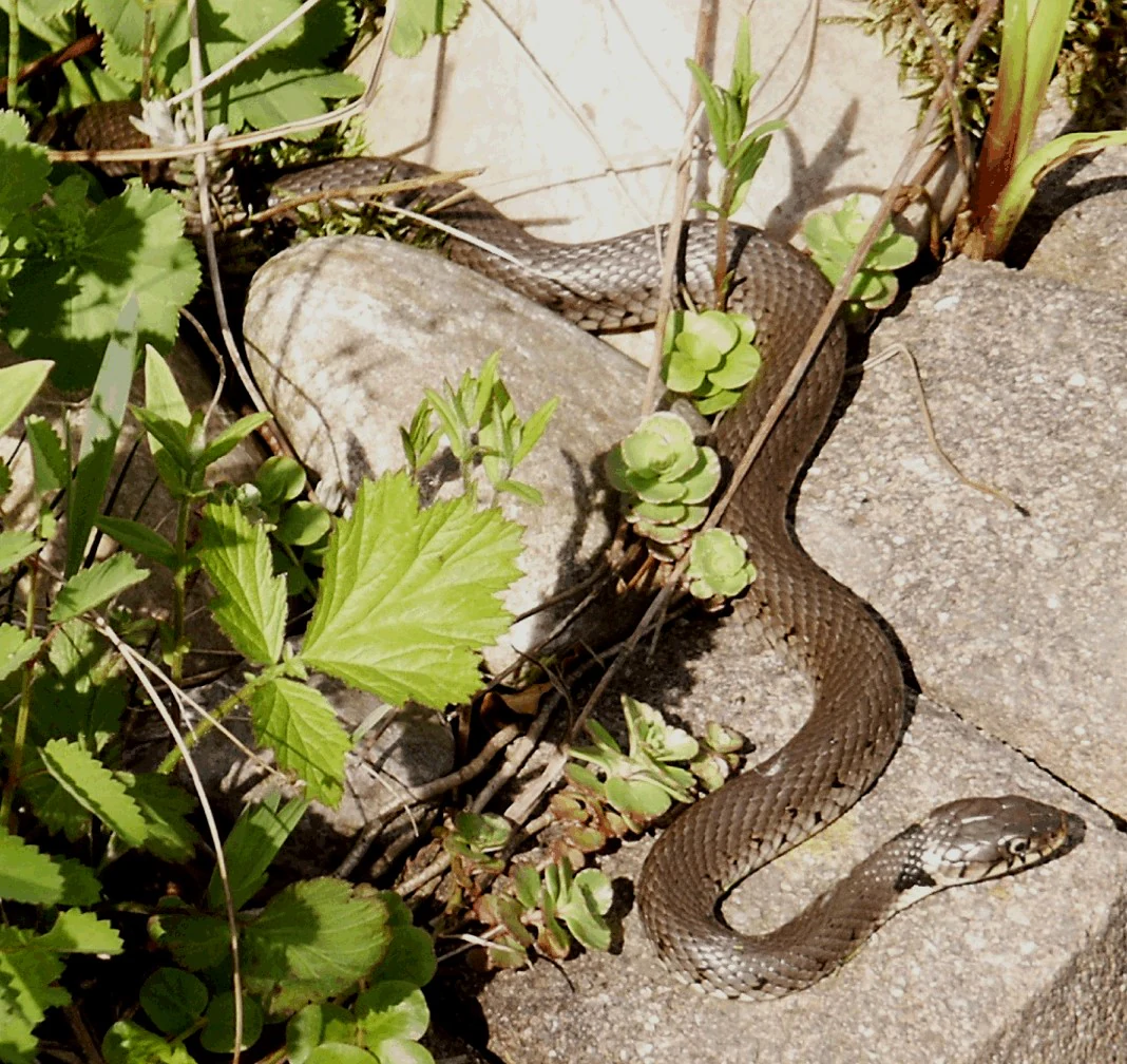
A grass snake with visible patterned scales and a distinct light-colored neck patch, resting on a gray stone surface surrounded by green leafy plants.
A grass snake, Natrix natrix, resting among rocks and vegetation in the Schwarzbachtal nature reserve.

Schwarzbachtal bei Götzenberg wildlife and species highlights

Wildlife is one of the principal reasons for the reserve's ecological importance. The Schwarzbach and its associated wet habitats support a community of bird species strongly tied to streams, reeds, and damp meadows. Breeders in the area include marsh warbler and Eurasian reed warbler, yellowhammer, reed bunting, grey wagtail, and the white-throated dipper, while the kingfisher regularly uses the stream as a feeding area.

Amphibians and reptiles are recognized as a particular conservation priority in the reserve. The grass snake (Ringelnatter) is highlighted as a species whose habitat requirements are explicitly addressed in the management plan, and the area's combination of ponds, wet woodland, and open grassland creates favorable conditions for both groups. Maintaining and creating new small water bodies and protecting spring zones are key actions taken to sustain these populations.

The deadwood-rich beech and mixed forests, together with the dense riparian vegetation, also support a wide invertebrate community, including saproxylic species associated with old trees and decaying wood. This invisible fauna is an important part of the reserve's ecological identity, linking forest structure to broader food-web function in the valley.
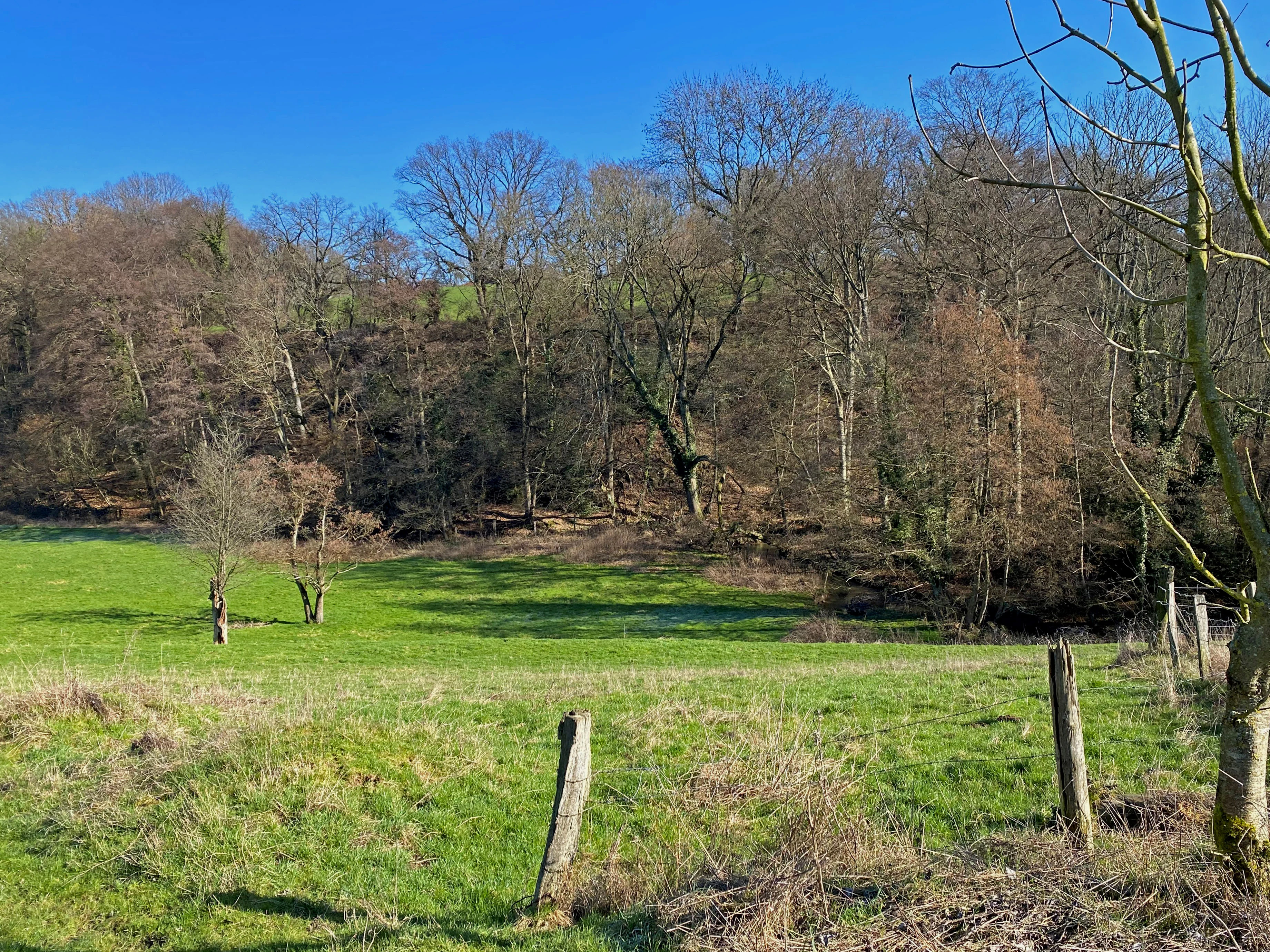
A green pasture framed by wooden fence posts in the foreground, leading to a dense deciduous forest at the base of a hill under a clear blue sky.
A view of the meadows and deciduous woodland in the Schwarzbachtal nature reserve.

Schwarzbachtal bei Götzenberg conservation status and protection priorities

As a formal Naturschutzgebiet, Schwarzbachtal bei Götzenberg is classified under IUCN Category IV as a Habitat/Species Management Area, reflecting its role in actively maintaining specific habitats and species rather than functioning solely as a strict nature reserve. The official protection number ME-011 ties it directly to the protected-area system of the Mettmann district.

The reserve's conservation significance lies in the combination of habitat preservation and habitat restoration. Protection aims emphasize maintaining old beech stands with sufficient amounts of strong deadwood, gradually replacing non-native hybrid poplars on floodplain sites with site-appropriate woodland, keeping damp meadows and reedbeds open against succession, restoring extensively used wet grassland, creating new small water bodies, and protecting natural springs. Renaturation of straightened stream sections and control of invasive species, particularly the giant hogweed, are also explicit goals.

Within the broader landscape, the reserve functions as a biodiversity refuge surrounded by golf courses, roads, and the suburban edge of Ratingen. Its isolation emphasizes the importance of even small, well-protected valley fragments for maintaining regional biodiversity and for preserving near-natural stream processes in an area otherwise heavily shaped by human land use.

Top sights and standout views in Schwarzbachtal bei Götzenberg

A compact valley reserve centered on a near-natural section of the Schwarzbach, combining ash-alder floodplain forest, old beech woodland with rich deadwood, wet meadows, reedbeds, and small ponds. The reserve stands out for the unusually complete habitat sequence preserved in an area bordered by two golf courses and crossed by the A3 autobahn, and for its importance to stream-associated birds, amphibians, and reptiles such as the grass snake.

Best time to visit Schwarzbachtal bei Götzenberg

Spring and early summer are typically the most rewarding seasons for visiting wet lowland reserves of this type, when the floodplain vegetation is at its lushest, reed and meadow flowers are in bloom, and breeding wetland birds are most active along the stream and reedbeds. Late spring mornings can be especially good for observing species such as white-throated dipper and grey wagtail along the Schwarzbach, while early summer offers the best chance to see reptiles and amphibians around the ponds and wet grassland margins. Autumn brings the visual character of the beech and mixed forest into focus, with mature stands and deadwood structures becoming more visible after leaf fall.

Monthly climate preview

Long-term representative point measurements tracking monthly temperature and precipitation variation

Schwarzbachtal bei Götzenberg Climate Normals and Annual Temperature Rhythm

Representative coordinates record measured monthly temperature swings from sub-zero winter minimums to warm summer maximums alongside consistent daily precipitation rates. Detailed long-term climate normals expand across all twelve monthly cycles to provide deeper analytical context for this protected area.
Annual mean10 °C
1 °C19 °C
Jan
Feb
Mar
Apr
May13°
Jun16°
Jul19°
Aug18°
Sep15°
Oct10°
Nov
Dec
Warmest month
July

18.6 °C

Coolest month
January

1.5 °C

Wettest month
December

2.8 mm/day

Driest month
April

1.6 mm/day

Park location guide

Geography guide, regional context, and park location map for Schwarzbachtal bei Götzenberg

Schwarzbachtal bei Götzenberg park geography, regions, and map view in Germany

Understand where Schwarzbachtal bei Götzenberg sits in Germany through a broader geographic reading of the surrounding landscape, nearby location context, and its mapped position within the national park landscape.

How Schwarzbachtal bei Götzenberg fits into Germany

Germany is a federal republic in Western and Central Europe with a population of over 83 million across sixteen constituent states. It is Europe's largest economy by nominal GDP and a major global exporter and importer. The capital is Berlin, and the country borders Denmark, Poland, Czech Republic, Austria, Switzerland, France, Luxembourg, Belgium, and the Netherlands.

Wider geography shaping Schwarzbachtal bei Götzenberg in Germany

Germany is located in Western and Central Europe, spanning 357,022 km². It borders Denmark to the north, Poland and the Czech Republic to the east, Austria and Switzerland to the south, and France, Luxembourg, Belgium, and the Netherlands to the west. The country has coastlines on the Baltic Sea and North Sea to the north, with the Alps located in the southern region.

Map view of Schwarzbachtal bei Götzenberg

Use this park location map to pinpoint Schwarzbachtal bei Götzenberg in Germany, understand its exact geographic position, and read its mapped placement within the surrounding landscape more clearly.

Pigeon | © OpenStreetMap contributors

Location context for Schwarzbachtal bei Götzenberg

Nordrhein-Westfalen

Visual exploration of protected stream valleys, beech forests, and wetland habitats

Schwarzbachtal bei Götzenberg Photos and Landscape Scenery

Visual documentation captures the near-natural stream courses, damp meadows, and old-growth beech stands defining the protected valley. Examining these habitat photographs reveals the ecological character and terrain diversity of the reserve more clearly.

A white-throated dipper with a dark brown body and a prominent white chest patch stands on a wet, mossy rock in a stream, carrying a small insect in its beak.

A small creek flows through a dense forest with mature trees and ivy, with a glimpse of an open green field in the background.

A small stream flows through a grassy meadow bordered by thin, bare-branched trees under a bright blue sky.

A grass snake with visible patterned scales and a distinct light-colored neck patch, resting on a gray stone surface surrounded by green leafy plants.

A green pasture framed by wooden fence posts in the foreground, leading to a dense deciduous forest at the base of a hill under a clear blue sky.

A small creek winds through a valley with grassy banks and bare trees in early spring.

Park atlas

Compare nearby valley reserves, river corridors, and protected landscapes across western Germany.

Other Parks Near Schwarzbachtal bei Götzenberg and Regional Protected Areas

Browsing other parks near Schwarzbachtal bei Götzenberg reveals the broader ecological context of the surrounding Bergisches Land region. Comparing adjacent protected areas helps trace similar stream valleys, floodplain forests, and wetland reserves throughout western Germany.
Nature reserveNordrhein-Westfalen
About 3.9 km away#1 closest

Northeast

Hofermühle Süd Nature Reserve: Mapped Protected Landscapes and Quarry Geography

Examining limestone quarry terrain and riparian zones in Nordrhein-Westfalen.

Explore the distinct geology of Hofermühle Süd, where a reclaimed limestone quarry meets the meandering Anger creek. This protected nature reserve in Nordrhein-Westfalen provides a vital study in secondary succession, showcasing thin calcareous soils, rare flora, and essential wetland habitats within a small but topographically varied site.

Area
0.166 km²
Established
1984
IUCN
IV
Relief
Lowland
Watercolor painting of a calm pond with cattails in the foreground and rolling hills in the background.
Nature reserveNorth Rhine-Westphalia
About 4.9 km away#2 closest

Southwest

Naturschutzgebiet Pillebachtal, Dernkamp und Gallberg: Protected Landscape and Geography

Nature reserve in North Rhine-Westphalia, Germany

An urban-adjacent nature reserve, this area provides a mapped look at the transition between mature beech forest stands and moist wetland corridors along the Pillebach stream. It serves as a study in ecological structure, featuring reed beds, meadow springs, and gallery woodlands that offer a protected refuge within the Rhine-Ruhr metropolitan region.

Area
0.745 km²
Established
1996
IUCN
IV
A soft, light watercolor painting of a green, rolling valley with trees and gentle hills, rendered in a minimalist style on a white background.
Nature reserveNordrhein-Westfalen
About 5.3 km away#3 closest

South

Hubbelrather Bachtal: Nature Reserve and Protected Stream Valley in Nordrhein-Westfalen

A diverse habitat mosaic from lowland wetlands to dry sandy slopes

Hubbelrather Bachtal is a protected nature reserve in the Mettmann district, defined by a basin-shaped valley floor along the Hubbelrather Bach. The area features a complex mosaic of reedbeds, sedge-rich grasslands, and beech woodland slopes, providing essential refuge for endangered species in the urbanized corridor between Düsseldorf and the Bergisches Land.

Area
28.29 km²
Established
1997
IUCN
IV
A watercolor painting showing a winding stream flowing through a green valley with soft hills and trees in the background.
Nature reserveKreis Mettmann
About 5.4 km away#4 closest

Southeast

Laubachtal Nature Reserve: Geographic Mapping of the Mettmann Wetland Corridor

A protected stream valley in Kreis Mettmann, Germany

Laubachtal functions as a critical 15 hectare nature reserve within the Mettmann district, preserving a mosaic of stream, pond, and wet meadow habitats. This protected area serves as an essential ecological corridor for amphibians and migratory birds, offering a focused look at small-scale conservation geography within the urban-edge environment of North Rhine-Westphalia.

Area
0.15 km²
Established
1997
IUCN
IV
Relief
Upland
Watercolor painting of a green valley with a winding stream and gentle hills in the background.
Nature reserveNordrhein-Westfalen
About 5.9 km away#5 closest

South

Morper Bachtal: Mapped Nature Reserve and Stream Valley Geography in Germany

Protected wetland landscapes and regional habitat connectivity.

Morper Bachtal represents a tightly layered protected area where open water, reedbeds, and beech forests converge along the Rotthäuser Bach. This detailed look at its landscape composition and position within the district of Mettmann reveals the significance of its compact, undulating terrain and corridor role in German regional geography.

Area
0.74 km²
Established
1984
IUCN
IV
Relief
Upland
A watercolor painting showing a soft, peaceful landscape with light green rolling hills in the background, a flat plain in the middle ground, and grasses and wildflowers in the foreground under a pale, warm sky.
Nature reserveNordrhein-Westfalen
About 6.7 km away#6 closest

Southeast

Laubacher Steinbruch Nature Reserve: Mapped Geographic Overview and Protected Landscape Analysis

Calcareous habitats in the Neandertal valley, Germany

Laubacher Steinbruch is a distinct nature reserve characterized by a mosaic of sycamore maple forest, steep limestone cliffs, and dry scree fields. Situated within the Neandertal Natura 2000 site, it acts as a critical refuge for specialized plant communities and reptiles, forming an integral part of the regional conservation network in Nordrhein-Westfalen.

Area
0.06 km²
Established
1997
IUCN
IV
A horizontal watercolor illustration of a calm stream flowing through a wetland with green trees and grasses along the banks.
Nature reserveNordrhein-Westfalen
About 7.2 km away#7 closest

Northwest

Hummelsbach Nature Reserve: Mapped Protected Brook and Floodplain Landscape in Nordrhein-Westfalen

Protected sandy stream and alder woodland mosaic

Located in the Mettmann district of Nordrhein-Westfalen, Hummelsbach preserves a near-natural sandy brook and alder floodplain forest. This reserve functions as an essential ecological bridge between rolling hill forests and lowland floodplains, providing a concentrated look at specialized habitats within a mosaic of meadows and wet woodland.

Area
0.13 km²
Established
1984
IUCN
IV
A soft watercolor painting of a serene river winding through a lush green valley with trees and ferns on the banks.
Nature reserveNordrhein-Westfalen
About 10 km away#8 closest

Northeast

Naturschutzgebiet Oefter Tal: Protected Stream Valley and Forest Geography

Nature reserve in Nordrhein-Westfalen, Germany

The Naturschutzgebiet Oefter Tal protects a unique intersection of running water, spring-fed tributaries, and deciduous woodland. This site in the southern Essen district offers a detailed look at the brook systems and valley forests that define the lower Ruhr region, providing an essential refuge for native habitat connectivity.

Area
0.312 km²
Established
1992
IUCN
IV
Relief
Upland

Common questions about visiting, size, designation, and location context for Schwarzbachtal bei Götzenberg

Schwarzbachtal bei Götzenberg FAQs for park facts, access, geography, and protected area context

Find quick answers about Schwarzbachtal bei Götzenberg, including protected-area facts, park geography, trail and visitor context, and how the park fits into its surrounding country and regional landscape.
MoriAtlas Explorer

Continue Your Protected Areas Search Across the Global Atlas

Deepen your exploration by continuing the structured search for national parks and protected areas worldwide. Utilize the comprehensive filtering capabilities to compare different conservation landscapes and refine your understanding of global park geography. Discover more about the distribution and characteristics of protected natural areas.

Global natural geography