

Mori Atlas logo
Nature reserveShoushan National Nature Park

Discover the geographic context and mapped terrain of this significant protected area.

Shoushan National Nature Park: Mapped Nature Reserve Boundaries and Protected Landscape Identity in Taiwan

Shoushan National Nature Park serves as a protected natural reserve within Taiwan, offering a distinct geographic identity for atlas-based exploration. This page details its mapped boundaries and unique landscape context, contributing to a broader understanding of Taiwan's protected lands. Users can explore its natural terrain and regional setting, gaining insight into the specific geography that defines this nature reserve.

volcanic landscapesubtropical forestTaiwan endemic speciesprimate habitathiking trailsrock formations

Shoushan National Nature Park

Nature reserve

Park overview

Structured park overview, official facts, and landscape profile for Shoushan National Nature Park

Shoushan National Nature Park park facts, protected area profile, and essential visitor context

Review the core facts for Shoushan National Nature Park, including designation, size, terrain, visitor scale, habitats, and operating context in one park-focused overview.

About Shoushan National Nature Park

Shoushan National Nature Park occupies a significant environmental and recreational role within Kaohsiung, Taiwan's major southern metropolis. The park's volcanic hills rise abruptly from the surrounding coastal lowland, creating a mountainous preserved area within easy reach of the city's population. The geological character of Shoushan reflects Taiwan's complex tectonic history, with volcanic activity having produced the andesitic rock formations that define the landscape's visual identity. The park's vegetation consists primarily of subtropical evergreen forest, with secondary growth and planted trees in areas that have experienced past human use. Trails traverse the hillsides, connecting scenic viewpoints, rock formations, and areas of ecological interest. The park functions as an important green infrastructure element for Kaohsiung, providing ecosystem services while offering residents and visitors access to nature without traveling to more remote protected areas.

Quick facts and research context for Shoushan National Nature Park

Shoushan National Nature Park is situated in Kaohsiung, Taiwan's third-largest city, approximately 30 kilometers from the city center. The reserve covers approximately 1,200 hectares of volcanic hillside terrain characterized by ridges, valleys, and rock outcrops. Elevation within the park ranges from roughly 200 to 350 meters above sea level. The geological foundation consists primarily of andesite and other volcanic rocks that date from the late Cenozoic period. The area falls within Taiwan's subtropical climate zone, receiving moderate rainfall concentrated during the summer monsoon season.

Park context

Deeper park guide and search-rich context for Shoushan National Nature Park

Shoushan National Nature Park history, landscape, wildlife, and travel context

Explore Shoushan National Nature Park through its history, landscape character, ecosystems, wildlife, conservation priorities, cultural context, and seasonal travel timing in a structured park guide built for atlas discovery and search intent.

Why Shoushan National Nature Park stands out

Shoushan National Nature Park is best known for its population of Formosan rock macaques, a species of endemic Taiwanese macaque that has adapted to the park's environment and frequently encountered along hiking trails. The park is also recognized for its volcanic geological features, particularly the distinctive rock formations and andesite cliffs that characterize the hill ridges. The panoramic views from the park's higher elevations, overlooking Kaohsiung's urban landscape and the Love River delta, represent another defining characteristic that attracts visitors.

Shoushan National Nature Park history and protected-area timeline

Shoushan National Nature Park was established as a protected area during Taiwan's era of environmental conservation development, which accelerated in the 1980s and 1990s as the island nation recognized the importance of preserving representative natural landscapes. The area had previously existed as a managed forest area and recreation zone under various administrative designations. Formal designation as a national nature park reflected the recognition of both the area's ecological value and its significance as a recreation resource for Kaohsiung's growing population. The establishment process involved coordination between national conservation authorities and local government, addressing the challenges of maintaining natural habitat within a rapidly urbanizing region.

Shoushan National Nature Park landscape and geographic character

The landscape of Shoushan National Nature Park is defined by its volcanic geological foundation, which creates a terrain of rounded hills, rocky ridges, and steep-sided valleys. The andesite volcanic rocks have weathered into distinctive formations including rock pillars, cliff faces, and boulder-strewn slopes. The highest points offer commanding views across the Kaohsiung metropolitan area to the south and west, extending toward the Taiwan Strait. Within the park, the terrain transitions from steeper slopes near the ridge crests to more gentle valleys and foothills. The underlying volcanic geology influences soil characteristics and drainage patterns, creating microhabitats that support diverse plant communities.

Shoushan National Nature Park ecosystems, habitats, and plant life

The ecological character of Shoushan reflects Taiwan's subtropical climate and the island's position within the Indomalayan biogeographic region. The park's forest communities include both mature evergreen woodland and areas of secondary growth that have regenerated following past human disturbance. Common tree species include various members of the laurel family, myrtles, and tropical hardwoods. The forest canopy provides habitat for numerous bird species, while the understory supports diverse plant life adapted to the partially shaded conditions. The park's position along the western foothills of the mountain range creates a transitional environment between lowland and higher elevation ecosystems.

Shoushan National Nature Park wildlife and species highlights

The Formosan rock macaque represents the most conspicuous wildlife species within Shoushan National Nature Park. These endemic primates have established population groups throughout the park and have become accustomed to the presence of human visitors, though they remain wild animals requiring respectful observation. Bird species found in the park include various passerines, bulbuls, and dove species common to Taiwan's lowland and foothill environments. Smaller mammals such as the Chinese pangolin and various rodent species occupy the park's forest habitats, though they are less frequently observed than the monkeys.

Shoushan National Nature Park conservation status and protection priorities

Shoushan National Nature Park contributes to Taiwan's protected area network by preserving an example of volcanic hill ecosystem within the island's heavily developed southwestern coastal region. The park's designation provides legal protection for its forest communities and wildlife habitats, limiting development and managing visitor access to minimize ecological impact. The macaque population represents a conservation success story, as the species has maintained viable numbers within the park despite the surrounding urban environment. Management efforts focus on maintaining ecological integrity while accommodating the recreational needs of Kaohsiung's residents.

Shoushan National Nature Park cultural meaning and human context

Shoushan holds cultural significance for the city of Kaohsiung, serving as a historic natural landmark that predates much of the surrounding urban development. The hills have long served as a scenic backdrop for the city and a destination for recreation and appreciation of natural scenery. The area's name, Shoushan, means 'longevity mountain' in Chinese, reflecting traditional naming practices that associate landscape features with auspicious meanings. The park's accessibility from central Kaohsiung makes it an important element of the city's green space network, providing residents with convenient access to nature without requiring travel to more distant conservation areas.

Best time to visit Shoushan National Nature Park

The optimal time to visit Shoushan National Nature Park falls during the cooler months from October through March, when temperatures are more comfortable for hiking and the likelihood of rainfall is reduced compared to the summer monsoon season. The winter months offer the most stable weather conditions, though any season can provide rewarding experiences. Visitors should be aware that summer brings higher temperatures and increased precipitation, while the period from May through September coincides with Taiwan's wet season. The monkeys can be observed throughout the year, though they may be more active during cooler parts of the day.
Monthly climate preview

Long-term representative temperature and precipitation averages for Taiwan

Shoushan National Nature Park Climate Normals and Monthly Weather Patterns

Shoushan National Nature Park exhibits measured annual temperature variations alongside distinct monthly precipitation averages derived from historical coordinate data. Examining the complete twelve-month climate profile provides detailed historical statistics for analytical reference.
Annual mean26 °C
21 °C29 °C
Jan21°
Feb22°
Mar23°
Apr25°
May27°
Jun28°
Jul29°
Aug29°
Sep28°
Oct27°
Nov25°
Dec23°
Warmest month
July

29 °C

Coolest month
January

21.2 °C

Wettest month
August

12.4 mm/day

Driest month
January

0.8 mm/day

Park location guide

Geography guide, regional context, and park location map for Shoushan National Nature Park

Shoushan National Nature Park park geography, regions, and map view in Taiwan

Understand where Shoushan National Nature Park sits in Taiwan through a broader geographic reading of the surrounding landscape, nearby location context, and its mapped position within the national park landscape.

How Shoushan National Nature Park fits into Taiwan

Taiwan is an island nation in East Asia situated between the East China Sea and South China Sea. With a population of approximately 23.3 million people, it is one of the most densely populated countries in the world. The island features mountain ranges dominating its eastern region and densely populated plains in the west, where major cities including Taipei and New Taipei City are located.

Wider geography shaping Shoushan National Nature Park in Taiwan

Taiwan is located in the western Pacific Ocean, bordered by the East China Sea to the northwest and the South China Sea to the southwest. The People's Republic of China lies to the northwest across the Taiwan Strait, Japan is to the northeast, and the Philippines are to the south. The main island features mountain ranges dominating the eastern two-thirds of the territory, with plains concentrated in the western third where the majority of the population resides.

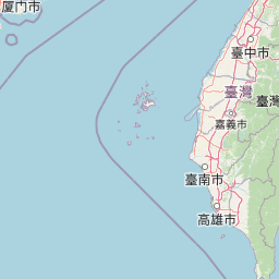
Map view of Shoushan National Nature Park

Use this park location map to pinpoint Shoushan National Nature Park in Taiwan, understand its exact geographic position, and read its mapped placement within the surrounding landscape more clearly.

Pigeon | © OpenStreetMap contributors

Location context for Shoushan National Nature Park

Kaohsiung
Park atlas

Trace the regional geography of other protected areas, exploring landscapes comparable to Shoushan National Nature Park.

Explore More Protected Areas: National Nature Parks and Landscapes Near Shoushan National Nature Park

Continue your exploration from Shoushan National Nature Park to browse additional protected areas in the surrounding region, mapping diverse landscapes from volcanic hills to subtropical forests. This geographic overview provides valuable context for comparing conservation efforts and understanding the distribution of natural parks near Kaohsiung.
National parkTainan
About 39 km away#1 closest

Northwest

Taijiang National Park: National Park Atlas and Protected Landscape Exploration

Discover mapped boundaries and regional geography.

Taijiang National Park offers a distinct look into protected natural landscapes within Tainan, Taiwan. This page details its identity as a national park, focusing on its mapped geographic features and its contribution to the regional atlas. Users can explore the specific protected area context and understand the landscape characteristics relevant to a structured geographic discovery approach.

Area
393.1 km²
Established
2009
IUCN
II
Relief
Lowland
National parkPingtung County
About 78 km away#2 closest

Southeast

Kenting National Park: Taiwan's Southern National Park Protected Landscape Identity

Mapped geography and regional context for this protected area.

Kenting National Park is a crucial protected area located in Pingtung County, Taiwan, representing a significant component of the nation's protected lands. This page provides detailed information ideal for atlas-driven exploration, focusing on the park's mapped geographic features, its role as a national park, and its contribution to understanding Taiwan's diverse landscapes. Discover the unique identity of Kenting National Park as a key element in regional conservation and geographic study.

Area
333 km²
Established
1984
IUCN
II
Visitors
5.8M annual
National parkTaiwan
About 84 km away#3 closest

Northwest

South Penghu Marine National Park: A Protected Volcanic Island Landscape in Taiwan's Penghu Archipelago

Mapped marine protected areas and unique geological features.

Discover the unique atlas value of South Penghu Marine National Park, Taiwan's protected national park renowned for its dramatic columnar basalt landforms and extensive coral reef systems. This marine protected area provides critical habitat for diverse species and showcases a rugged island geography shaped by volcanic activity. Explore its mapped boundaries and unique geological formations, including famous sea caves, offering a distinct context for landscape discovery.

Area
358.44 km²
Established
2014
IUCN
II
Visitors
8.4K annual
National parkNantou County
About 90 km away#4 closest

Northeast

Yushan National Park: Explore Taiwan's Highest Mountain and Alpine Protected Terrain

Mapped geography and dramatic peaks within Nantou County.

Yushan National Park is a crucial protected area in Taiwan, renowned for encompassing the island's highest mountain and a significant portion of the Central Mountain Range. This national park's dramatic geography spans over 103,000 hectares, with two-thirds of its territory lying above 2,000 meters. Its vertical ecological zones, from subtropical forests to alpine environments, offer a rich tapestry of landscapes ideal for atlas-style exploration of protected terrain and mountain peak geography.

Area
1,031.21 km²
Established
1985
IUCN
II
Visitors
1M annual
National parkHualien County
About 189 km away#5 closest

Northeast

Taroko National Park: Detailed National Park Geography and Protected Landscape Context

Explore mapped boundaries and natural terrain in Hualien County.

Taroko National Park represents a significant protected landscape within Taiwan, offering rich opportunities for geographical exploration and understanding protected-area distribution. As a designated national park, its mapped boundaries and unique terrain provide essential context for appreciating the natural geography of Hualien County and the surrounding region. This page supports detailed discovery of Taroko National Park's identity as a distinct protected area, ideal for atlas-based research and landscape comprehension.

Area
920 km²
Established
1986
IUCN
II
Relief
Mountain
National parkMiaoli County
About 198 km away#6 closest

Northeast

Shei-Pa National Park: Explore Taiwan's National Park Protected Landscape in Miaoli County

Mapped geographic boundaries and regional park context.

Shei-Pa National Park is a vital protected area in Miaoli County, Taiwan, offering rich opportunities for geographic and atlas-based exploration. Delve into the specifics of its mapped park boundaries and understand its role within the broader regional landscape. This destination provides essential context for discovering Taiwan's protected natural areas and their unique geographic characteristics.

Area
768.5 km²
Established
1992
IUCN
II
Relief
Mountain
National parkKinmen County
About 273 km away#7 closest

Northwest

Kinmen National Park: National Park Protected Landscape and Geographic Context

Mapped boundaries and regional park geography for atlas exploration.

Kinmen National Park stands as a significant protected area within Kinmen County, Taiwan. This page focuses on its identity as a national park, detailing its mapped boundaries and contributing to an understanding of its regional geographic context. It is designed for users seeking to explore the park's protected landscape features and its position within the broader atlas of natural areas.

Area
35.29 km²
Established
1995
IUCN
II
Relief
Upland
National parkTaiwan
About 309 km away#8 closest

Northeast

Yangmingshan National Park: Volcanic Terrain and Geothermal Features Atlas

Explore Taiwan's protected national park geography and mapped landscapes.

Yangmingshan National Park presents a striking example of volcanic geography, characterized by its rugged mountain terrain, active craters like Xiaoyoukeng, and ubiquitous geothermal features such as hot springs and sulfur deposits. As a protected national park within Taiwan, its landscape offers a rich context for understanding volcanic processes and alpine ecosystems. MoriAtlas provides detailed map exploration of Yangmingshan National Park, highlighting its unique geological formations and protected boundaries for an in-depth geographic discovery experience.

Area
113 km²
Established
1985
IUCN
II

Common questions about visiting, size, designation, and location context for Shoushan National Nature Park

Shoushan National Nature Park FAQs for park facts, access, geography, and protected area context

Find quick answers about Shoushan National Nature Park, including protected-area facts, park geography, trail and visitor context, and how the park fits into its surrounding country and regional landscape.
MoriAtlas Explorer

Continue Your Protected Areas Search Across the Global Atlas

Deepen your exploration by continuing the structured search for national parks and protected areas worldwide. Utilize the comprehensive filtering capabilities to compare different conservation landscapes and refine your understanding of global park geography. Discover more about the distribution and characteristics of protected natural areas.

Global natural geography