Mori Atlas logo
National parkSiniaka-Minia National Park

Understand the mapped boundaries and regional geography of this vital national park.

Siniaka-Minia National Park: A Protected Landscape for Atlas Discovery in Chad

Siniaka-Minia National Park represents a significant protected landscape within the Republic of Chad, offering users an essential entry point for atlas-driven geographic exploration. This page provides context on the park's identity as a national park, highlighting its position within Chad's diverse terrain and its role in the conservation of natural landscapes. Engage with structured data to understand the park's mapped features and its contribution to the broader regional geography of Central Africa.

savanna protected areawildlife conservationcentral Africalarge mammal habitatIUCN Category IVAfrican Parks managed

Siniaka-Minia National Park

National park

Park overview

Structured park overview, official facts, and landscape profile for Siniaka-Minia National Park

Siniaka-Minia National Park park facts, protected area profile, and essential visitor context

Review the core facts for Siniaka-Minia National Park, including designation, size, terrain, visitor scale, habitats, and operating context in one park-focused overview.

About Siniaka-Minia National Park

Siniaka-Minia National Park represents one of Chad's most significant protected areas, located in the central part of the country across the Guéra and Moyen-Chari regions. The park encompasses approximately 4,260 square kilometers of terrain, making it a substantial conservation area within the nation. Its establishment in 1965 reflected Chad's commitment to preserving unique ecosystems and endangered species, particularly the black rhinoceros which was the primary motivation for creating the protected area. The landscape is characterized by extensive plain terrain that is backdropped by a dramatic massif reaching 1,613 meters in elevation, creating a visually striking environment. The park's hydrology is defined by ephemeral river systems including the Siniaka River and Dorioum River, which flow seasonally and leave behind water holes that become critical water sources for wildlife during the hot summer months. In 2017, management of the reserve was transferred to African Parks, a nonprofit conservation organization with a strong track record in African protected area management, particularly following their success at Zakouma National Park. The transition to national park status in 2023 reflected the growing importance of this area within Chad's conservation portfolio. The park supports ecosystems that transition from Sudan savanna in the southern portions to thorny bush vegetation in the northern areas, with wetlands providing additional ecological diversity. This variety of habitats supports numerous wildlife species, though the park has faced significant challenges from poaching that led to the loss of black rhinoceros populations decades ago.

Quick facts and research context for Siniaka-Minia National Park

Siniaka-Minia National Park is situated in central Chad within the Guéra and Moyen-Chari regions, covering 4,260 square kilometers of protected terrain. The park was established in 1965 and was managed as a reserve before being upgraded to national park status in 2023. It is classified as an IUCN Category IV habitat and species management area. The landscape consists primarily of flat plains bordered by a mountainous massif reaching 1,613 meters in elevation. The park is drained by ephemeral rivers and contains seasonal waterholes critical for wildlife survival during dry periods. Conservation management transferred to African Parks in 2017, marking a significant partnership between the nonprofit organization and Chad's government.

Protection and recognition

Navigating the official designation framework, terrestrial scope, and management records

Siniaka-Minia National Park Protected Area Designation and Recognition Profile

Map-based researchers can analyze the official terrestrial protection status and the 2023 designation history established for Siniaka-Minia National Park. Tracking legal boundary frameworks and historical conservation milestones provides essential geographic context for studying regional networks of protected landscapes.

Protection details

Protection scope
Terrestrial
Designated year
2023
Transboundary protection
No
Park context

Deeper park guide and search-rich context for Siniaka-Minia National Park

Siniaka-Minia National Park history, landscape, wildlife, and travel context

Explore Siniaka-Minia National Park through its history, landscape character, ecosystems, wildlife, conservation priorities, cultural context, and seasonal travel timing in a structured park guide built for atlas discovery and search intent.

Why Siniaka-Minia National Park stands out

Siniaka-Minia National Park is best known for its role as a flagship conservation area in Chad, originally established to protect the black rhinoceros. The park encompasses a remarkable diversity of habitats ranging from open savanna plains to wetland areas, supporting populations of greater kudu, red-fronted gazelle, oribi, roan antelope, lion, and cheetah. It gained notable recognition in 2022 when African Parks conducted the largest buffalo translocation in history, moving over 900 animals from Zakouma National Park to bolster wildlife populations. The park's management by African Parks since 2017 has brought increased anti-poaching efforts and infrastructure development to this ecologically significant region of central Africa.

Siniaka-Minia National Park history and protected-area timeline

Siniaka-Minia was established in 1965 as a protected reserve with the specific goal of conserving black rhinoceros populations in central Chad. The designation reflected the species' historical presence in the region and the need for formal protection measures. Initially categorized as an IUCN Category IV protected area, the reserve was created to manage habitats and protect species populations. However, despite the protective status, poaching pressures proved overwhelming, and the black rhinoceros was driven to local extinction by the late 1970s. For decades, the reserve continued to function with limited resources and ongoing challenges from illegal hunting. A significant turning point occurred in 2017 when management responsibilities were transferred to African Parks, a nonprofit organization that had demonstrated success at Zakouma National Park. This partnership brought new resources, professional management, and improved anti-poaching capabilities to the reserve. In 2022, the reserve received a major wildlife boost when African Parks conducted the largest buffalo translocation ever undertaken, moving over 900 animals from Zakouma National Park to strengthen populations and reduce pressure on surrounding agricultural lands. The following year, in 2023, the reserve was formally elevated to national park status, marking a new chapter in its conservation history and reflecting Chad's strengthened commitment to protecting this landscape.

Siniaka-Minia National Park landscape and geographic character

The physical landscape of Siniaka-Minia National Park is characterized by its distinctive combination of flat savanna plains and mountainous terrain. The park sits on a large plain area that extends across much of the protected territory, providing open vistas and typical African savanna scenery. This plain is backdropped by a prominent massif that rises to 1,613 meters, creating a dramatic eastern boundary and adding topographic diversity to the park. The hydrological system is defined by two main river courses, the Siniaka River and the Dorioum River, both of which are ephemeral in nature. These rivers flow during wet seasons but dry up for significant portions of the year, leaving only isolated water holes scattered across the landscape. These water holes become critical refuges for wildlife during the hot summer months when surface water becomes scarce. The combination of open plains, mountain backdrop, and seasonal water systems creates a landscape of ecological importance that supports both savanna and wetland habitats within a relatively compact geographic area.

Siniaka-Minia National Park ecosystems, habitats, and plant life

The ecological character of Siniaka-Minia National Park encompasses a notable diversity of habitat types across its 4,260 square kilometer extent. The park transitions between distinct vegetation zones, with the southern portions characterized by Sudan savanna consisting of grasslands and scattered trees, while the northern areas feature thorny bush vegetation typical of more arid regions. Between these extremes, the park contains important wetland areas that provide critical habitat diversity and support water-dependent species. The variety of ecosystems from savanna to wetlands gives the park ecological significance beyond what a single habitat type would provide. The presence of seasonal rivers and remaining water holes during dry periods creates ephemeral wetland features that are vital for wildlife survival. This ecological diversity, while facing pressures from poaching and human activity, remains the foundation for the park's conservation value and supports the diverse wildlife species that inhabit the area.

Siniaka-Minia National Park wildlife and species highlights

Siniaka-Minia National Park supports a range of notable wildlife species despite the significant challenges the ecosystem has faced. The park was originally established to protect black rhinoceros populations, though this species was lost to poaching by the late 1970s. The protected area continues to harbor several threatened species including greater kudu, red-fronted gazelle, oribi, and roan antelope. Predatory species present in the park include lion and cheetah, representing important apex predators within the ecosystem. A major wildlife restoration effort occurred in January and February 2022 when African Parks conducted the largest buffalo translocation in history, moving over 900 African buffalo from Zakouma National Park to Siniaka-Minia. Many of these animals came from a herd at the outskirts of Zakouma that risked moving into agricultural lands, making the translocation beneficial for both wildlife and local communities. The park's wildlife populations continue to face pressures from poaching, but the presence of multiple threatened species maintains its conservation significance.

Siniaka-Minia National Park conservation status and protection priorities

Siniaka-Minia National Park holds significant conservation importance within Chad's protected area network, despite facing persistent challenges. The park was originally established to protect black rhinoceros populations, reflecting the species' historical presence in the region, and maintains designation as an IUCN Category IV protected area. While the black rhinoceros was lost to poaching decades ago, the park continues to preserve habitat for multiple threatened species including greater kudu, red-fronted gazelle, oribi, and roan antelope. Conservation management by African Parks since 2017 has brought increased anti-poaching efforts, though well-armed hunters continue to pose difficulties for effective surveillance. The organization has prioritized wildlife monitoring, infrastructure development, and collaboration with local law enforcement. The elevation to national park status in 2023 signaled Chad's strengthened commitment to conservation in the region. Ongoing challenges include the need for adequate personnel and equipment for effective patrol operations, while the park's mammal populations require continued protection. The 2022 buffalo translocation demonstrated active habitat management and species restoration efforts that go beyond basic protection.

Siniaka-Minia National Park cultural meaning and human context

Siniaka-Minia National Park exists within a landscape where local communities maintain agricultural activities, particularly farming that brings them into proximity with the protected area. The establishment and expansion of the park have created some tensions with local farmers regarding land use. The Minister of the Environment, Fisheries and Sustainable Development has committed to supporting local residents with access to water and other measures to sustain their economic activities. This human dimension reflects the reality that protected areas in Chad function within a context of ongoing human settlement and land use, requiring careful balance between conservation goals and community livelihoods.

Top sights and standout views in Siniaka-Minia National Park

Siniaka-Minia National Park stands out as a major conservation landscape in central Chad, featuring dramatic mountain-backed savanna scenery and diverse habitats ranging from open plains to wetlands. The park's upgrade from reserve to national park in 2023 marked an important milestone, while the 2022 buffalo translocation of over 900 animals represented the largest such effort in history. The area provides crucial habitat for species including greater kudu, red-fronted gazelle, roan antelope, lion, and cheetah. Management by African Parks has brought renewed conservation focus and anti-poaching efforts to a region that had struggled with wildlife crime. The ephemeral river systems and seasonal water holes create a dynamic landscape that cycles between wet and dry conditions, adding ecological interest to this significant protected area.

Monthly climate preview

Long-term representative measurements of monthly temperature and precipitation patterns

Siniaka-Minia National Park Climate Normals and Annual Weather Rhythm

Representative coordinate records show average monthly temperatures peaking above 34 degrees Celsius alongside distinct seasonal shifts in daily precipitation. Detailed twelve-month climate normals provide a complete picture of long-term temperature ranges and rainfall distribution.
Annual mean29 °C
25 °C34 °C
Jan27°
Feb30°
Mar33°
Apr34°
May32°
Jun30°
Jul27°
Aug25°
Sep26°
Oct27°
Nov27°
Dec26°
Warmest month
April

34.1 °C

Coolest month
August

25.5 °C

Wettest month
August

8.3 mm/day

Driest month
January

0 mm/day

Park location guide

Geography guide, regional context, and park location map for Siniaka-Minia National Park

Siniaka-Minia National Park park geography, regions, and map view in Chad

Understand where Siniaka-Minia National Park sits in Chad through a broader geographic reading of the surrounding landscape, nearby location context, and its mapped position within the national park landscape.

How Siniaka-Minia National Park fits into Chad

Chad is a landlocked Central African nation spanning approximately 1.28 million km². It borders six countries and contains three distinct regions: the Sahara desert in the north, the Sahel in the center, and the Sudanian Savanna in the south. Lake Chad, after which the country is named, is the second-largest wetland in Africa. Chad gained independence from France in 1960 and has a population of about 19 million.

Wider geography shaping Siniaka-Minia National Park in Chad

Chad is located in Central Africa and is landlocked, bordered by six countries. The terrain varies from the Sahara desert in the north through the Sahel arid zone in the center to the more fertile Sudanian Savanna in the south. Lake Chad, a major shallow wetland, lies in the southwestern part of the country near the Nigeria border.

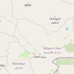
Map view of Siniaka-Minia National Park

Use this park location map to pinpoint Siniaka-Minia National Park in Chad, understand its exact geographic position, and read its mapped placement within the surrounding landscape more clearly.

Pigeon | © OpenStreetMap contributors

Location context for Siniaka-Minia National Park

GuéraMoyen-Chari
Park atlas

Trace the protected landscapes and savanna ecosystems surrounding Siniaka-Minia National Park across the Chad region.

Discover Other National Parks and Protected Areas Near Siniaka-Minia National Park in Central Chad

Browse other national parks and protected areas located geographically close to Siniaka-Minia National Park, spanning central Chad's diverse savanna and wetland habitats. Comparing these protected landscapes offers a deeper understanding of regional conservation efforts and distinct ecosystem characteristics beyond a single park's boundaries.
National parkGuéra Region
About 141 km away#1 closest

East

Zakouma National Park: Chad's Premier National Park and Protected Landscape

Explore the mapped savanna, acacia forests, and wildlife geography.

Zakouma National Park is Chad's oldest and most ecologically vital protected area, spanning 3,000 square kilometers of Sudano-Sahelian landscape. Situated within the Guéra Region, it is globally recognized for its exceptional Kordofan giraffe population, significant elephant recovery, and ongoing conservation successes, offering a unique view into African wildlife and protected area management.

Area
3,000 km²
Established
1963
IUCN
II
Relief
Lowland
National parkMoyen-Chari Region
About 142 km away#2 closest

South

Manda National Park: National Park Protected Landscape and Geographic Identity in Moyen-Chari

Discover mapped terrain and regional context for this Chad national park.

Manda National Park, a protected natural area within Chad's Moyen-Chari Region, offers valuable insights into regional geography and mapped protected landscapes. This detail page provides focused information on the park's identity as a national park, emphasizing its geographic setting and the importance of its mapped boundaries for structured atlas exploration. Understand how this protected area contributes to the diverse natural terrain of the Moyen-Chari Region.

Area
1,140 km²
Established
1969
IUCN
II
Climate
Tropical
National parkChad
About 244 km away#3 closest

East

Aouk National Park National Park: Mapped Protected Landscape and Regional Geography

Explore Chad's Aouk National Park boundaries and terrain.

Investigate Aouk National Park, a significant national park in Chad, through its detailed mapping and protected landscape attributes. This entry provides insight into the park's geographic placement within Central Africa, emphasizing its role as a conservation area. Users can explore the mapped boundaries and regional geographic context, facilitating a structured understanding of this protected territory for atlas-based research and discovery.

Area
7,400 km²
IUCN
II
Access
Moderate access
Scope
Terrestrial
National parkCentral African Republic
About 355 km away#4 closest

Southeast

Bamingui-Bangoran National Park: Protected Landscape and Geographic Context in Central Africa

Explore the savanna, forest, and riverine landscapes of this expansive national park.

Bamingui-Bangoran National Park represents a significant protected area within the Central African Republic, offering a rich landscape for geographic exploration. This page details the park's extensive savanna and tropical dry forest habitats, its role within the Guinea-Congo Forest biome, and its vital river systems like the Bamingui and Bangoran Rivers. Gain a clear understanding of its protected boundaries and its importance in regional conservation, providing valuable context for atlas-based discovery of Central African natural landscapes.

Area
11,191 km²
Established
1993
IUCN
II
Relief
Upland
National parkFar North Region
About 375 km away#5 closest

West

Waza National Park: A Designated Protected Landscape in the Far North Region

Mapped Boundaries and Regional Geographic Context

Waza National Park stands as a vital protected natural landscape in Cameroon's Far North Region. This entry provides a deep dive into its mapped protected-area boundaries and its significance within the broader regional geography. Explore the specific landscape identity of this national park through an atlas-focused lens, understanding its terrain and context without travel logistics or visitor advice.

Area
1,700 km²
Established
1934
IUCN
II
Relief
Lowland
National parkExtrême-Nord
About 382 km away#6 closest

West

Parc national de Ma Mbed Mbed: Geography and Protected Landscape Map Details

Extrême-Nord savanna buffer and transboundary conservation corridor.

Parc national de Ma Mbed Mbed is a key protected area covering 181 square kilometers of transitional savanna in Cameroon. Its location at the edge of the Sahelian zone creates a unique ecological interface, supporting critical elephant corridors and complex water-dependent vegetation patterns that feed into transregional river basins.

Area
181 km²
Established
2009
IUCN
II
Relief
Lowland
National parkExtrême-Nord
About 389 km away#7 closest

Northwest

Parc national de Kalamaloué: A Deep Geographic Analysis of Cameroon's Yaéré Floodplain

Mapped protected landscapes along the Logone and Chari rivers.

Parc national de Kalamaloué serves as a prime case study for sudano-sahelian geography, defined by its flat terrain and the seasonal inundation of the Logone basin. The park provides an essential look at how river hydrology influences small-scale protected habitats, ranging from dense mangrove fringes to dry acacia-dominated woodlands.

Area
45 km²
Established
1972
IUCN
II
Relief
Lowland
National parkSila Province
About 397 km away#8 closest

Northeast

Goz Beïda National Park: National Park Protected Landscape and Geographic Context

Explore mapped boundaries and regional terrain.

Gain a structured understanding of Goz Beïda National Park, a key protected area within Sila Province. This detail page provides insights into its geographic setting, offering mapped landscape context for atlas-based discovery. Learn about the park's specific protected area identity and its position within the regional geography.

Area
3,000 km²
IUCN
II
Scope
Terrestrial
Water
No major water

Common questions about visiting, size, designation, and location context for Siniaka-Minia National Park

Siniaka-Minia National Park FAQs for park facts, access, geography, and protected area context

Find quick answers about Siniaka-Minia National Park, including protected-area facts, park geography, trail and visitor context, and how the park fits into its surrounding country and regional landscape.
MoriAtlas Explorer

Continue Your Protected Areas Search Across the Global Atlas

Deepen your exploration by continuing the structured search for national parks and protected areas worldwide. Utilize the comprehensive filtering capabilities to compare different conservation landscapes and refine your understanding of global park geography. Discover more about the distribution and characteristics of protected natural areas.

Global natural geography