Why Surman National Park stands out
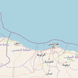
Surman National Park is primarily known for its coastal Mediterranean setting and its proximity to one of Libya's most significant archaeological sites, the ancient Roman city of Sabratha. The park represents a small but meaningful protected area within Libya's limited network of national parks, serving as a coastal conservation example in a country where desert environments dominate the landscape. Its establishment in 1992 reflects Libya's commitment to preserving non-desert ecosystems, particularly along the Mediterranean fringe where vegetation, wildlife, and human settlement have historically concentrated.
Surman National Park history and protected-area timeline
Surman National Park was established in 1992 as part of Libya's developing national park system. The creation of the park reflected a growing recognition among Libyan authorities of the need to protect coastal ecosystems and natural areas beyond the vast desert regions that dominate the country. The park's establishment coincided with broader environmental policy efforts in Libya during the late 20th century, a period when many nations were expanding their protected area networks. The proximity of the park to Sabratha, an ancient Roman city with origins dating to the 1st century BCE, places this protected area within a region of profound historical significance. Sabratha was one of the three cities of the Tripolis region and served as an important Roman trading settlement. The park's location near this archaeological treasure creates a meaningful connection between natural preservation and cultural heritage conservation in the area.
Surman National Park landscape and geographic character
The landscape of Surman National Park reflects its Mediterranean coastal setting in northwestern Libya. The terrain in this region generally consists of low-lying coastal plains that gradually transition to gently rolling hills as one moves inland from the sea. The Mediterranean coastline in this area features sandy shores and shallow waters along the North African shore. The climate of the region is Mediterranean, characterized by hot, dry summers and mild, relatively wet winters, with annual precipitation typically low but sufficient to support scrubland and steppe vegetation. The park's 400-hectare area encompasses coastal and near-coastal terrain, likely featuring the characteristic vegetation of the Mediterranean Basin in this latitude, including drought-resistant shrubs, herbaceous plants, and potentially some tree cover in areas with better water availability.
Surman National Park ecosystems, habitats, and plant life
The natural environment of Surman National Park represents Libya's Mediterranean coastal ecosystems, which form a narrow but ecologically distinct strip along the country's northern border. This region supports vegetation communities adapted to the Mediterranean climate, characterized by hot dry summers and a pronounced dry season. The flora of such coastal areas typically includes various species of scrub, thorny shrubs, and herbaceous plants that have evolved to tolerate seasonal drought and salt-laden coastal winds. While specific documentation of the park's biodiversity is limited, the Mediterranean Basin is recognized as a global biodiversity hotspot, hosting numerous endemic species. The coastal and near-coastal habitats within the park likely support birdlife, small mammals, and invertebrate species adapted to this transitional environment between the desert interior and the productive marine zone.
Surman National Park wildlife and species highlights
The wildlife present in Surman National Park would reflect the Mediterranean coastal ecosystems of northwestern Libya, a region that supports species adapted to semi-arid conditions and seasonal variations. Birdlife likely represents the most diverse group, as the Mediterranean Flyway passes through this coastal zone, bringing migratory species during seasonal transitions. Small mammals common to North African coastal areas, including various rodent species and potentially small carnivores such as foxes, may inhabit the park's terrestrial environments. The marine coastal zone likely supports fish species, marine invertebrates, and potentially coastal bird species that feed along the shoreline. While comprehensive species lists for the park are not available in the source material, the Mediterranean coastal ecosystem provides habitat for a range of adapted species.
Surman National Park conservation status and protection priorities
Surman National Park represents a conservation priority for Libya as one of the country's designated national parks protecting non-desert environments. The park's coastal location places it within the Mediterranean Basin, a globally significant biodiversity hotspot requiring conservation attention. Libya's national park system, of which Surman is a part, aims to preserve representative examples of the country's ecological diversity, including the limited but ecologically important Mediterranean coastal zone. The 1992 establishment date places the park within a period of increased environmental awareness in Libya and reflects early efforts to establish a structured protected area network. The park's small size makes it a focused conservation unit, likely allowing for relatively intensive management of its 400-hectare extent.
Surman National Park cultural meaning and human context
The cultural context of Surman National Park is deeply enriched by its proximity to the ancient Roman city of Sabratha, located nearby along the Libyan coast. Sabratha was an important Roman settlement founded in the 1st century BCE and became one of the three cities comprising the Tripolis region, alongside Oea (modern Tripoli) and Leptis Magna. The city's ruins represent one of Libya's most significant archaeological treasures, featuring a well-preserved Roman theater, temples, and residential structures. The presence of this ancient site near Surman National Park creates a cultural landscape where natural preservation intersects with historical heritage. The region has been inhabited for thousands of years, with various civilizations leaving their mark on the coastal zone between Tripoli and the Tunisian border.
Top sights and standout views in Surman National Park
The defining highlights of Surman National Park include its coastal Mediterranean setting along Libya's northwestern shore, its establishment as a protected area in 1992, and its proximity to the ancient Roman ruins of Sabratha. The park provides a conservation anchor for coastal ecosystems in a country where desert environments predominate, making it a notable example of Libya's efforts to protect its Mediterranean environmental heritage. The 400-hectare park represents a modest but meaningful contribution to Libya's protected area network, preserving a slice of the Mediterranean coastal ecosystem that has hosted human settlement and activity for millennia.
Best time to visit Surman National Park
The optimal time to visit Surman National Park would likely coincide with Libya's cooler winter months, from approximately November through March, when Mediterranean coastal temperatures are more comfortable for outdoor exploration. Summer months in this region can bring extreme heat, particularly inland, though coastal breezes provide some moderation. The winter period also tends to see higher visitor activity in Libya more broadly, though it's worth noting that Libya's tourism infrastructure has faced significant challenges in recent decades. Visitors interested in combining natural exploration with the nearby archaeological site of Sabratha may find the cooler months more suitable for walking tours of the ancient ruins as well. Spring, particularly late March through April, can also offer pleasant conditions and the possibility of seeing vegetation in bloom following the winter rainy season.