
Mori Atlas logo
Protected landscapeSouth Lewis, Harris and North Uist National Scenic Area

A vast island ecosystem spanning mountains, machair beaches, and intricate sea lochs.

South Lewis, Harris and North Uist National Scenic Area: Mapped Protected Landscapes

The South Lewis, Harris and North Uist National Scenic Area represents the largest protected landscape in Scotland, encompassing over 2,000 square kilometres of the northern Outer Hebrides. This vast region unites ancient Lewisian gneiss mountains, including the highest peak in the Outer Hebrides, with extensive peatland complexes and a complex, fjardic Atlantic coastline. From the machair grasslands of the west to the scattered islands of the Sound of Harris, the area preserves a unique interaction between dramatic island topography and a vital maritime marine environment.

national scenic areaOuter HebridesScottish islandscoastal scenerymachairpeatlands
A stylized flat-design illustration of a rugged coastline with cliffs, sandy beaches, and turquoise water under a soft, sunset-colored sky.

South Lewis, Harris and North Uist National Scenic Area

Protected landscape

Park overview

Structured park overview, official facts, and landscape profile for South Lewis, Harris and North Uist National Scenic Area

South Lewis, Harris and North Uist National Scenic Area park facts, protected area profile, and essential visitor context

Review the core facts for South Lewis, Harris and North Uist National Scenic Area, including designation, size, terrain, visitor scale, habitats, and operating context in one park-focused overview.

About South Lewis, Harris and North Uist National Scenic Area

South Lewis, Harris and North Uist is a national scenic area in the Western Isles of Scotland, recognised as the country's largest designation of its type. It stretches across the northern portion of the Outer Hebrides, taking in the south-west of Lewis, all of Harris, the Sound of Harris with its scattered islands, and the northern reaches of North Uist. Together the land and sea form a continuous scenic landscape where mountains, freshwater lochs, marine waters, peatlands, machair grasslands and remote settlements combine into a single protected setting.

The coastal scenery is a defining element. The east coast of Harris is broken by deep sea lochs, bays and small islets, while the west coast features wide sandy beaches associated with machair, a fertile coastal grassland system unique to the north-west Atlantic. Rocky headlands between the beaches have been eroded into geos, narrow inlets cut by the sea, and isolated stacks. The Sound of Harris separates Harris from North Uist, dotted with low-lying islands such as Taransay, Pabbay and Berneray, each contributing to the varied coastline.

Inland, the terrain contrasts sharply with the coast. North Harris rises to Clisham, at 799 metres the highest mountain in the Outer Hebrides, surrounded by steep-sided glens and precipitous crags. Exposure and grazing have prevented tree growth, so the hills remain largely open, with montane vegetation, heather, and rocky outcrops dominating the slopes. Loch Langavat and the Grimersta river and loch system on Lewis form a major freshwater corridor, recognised as the best Atlantic salmon system in the Western Isles.

North Uist contributes a different visual rhythm, defined by extensive deep peatland cut by waterways and lochs, and by the unusual fjardic sea loch at Loch nam Madadh, sometimes anglicised as Lochmaddy. This sea loch is part of one of the most extensive and diverse water systems in Europe, mixing salt and fresh water in a way that supports an unusual range of intertidal and aquatic species. Settlement is sparse, with Lochmaddy acting as a ferry terminal and small harbour for creel fishing and salmon farming.

The national scenic area designation does not create a national park authority. Instead, planning protection is delivered through NatureScot and the local authority, Comhairle nan Eilean Siar. Within the broader NSA boundary lie several overlapping international and national nature conservation designations, including Special Protection Areas and Special Areas of Conservation covering machair, peatlands, montane habitats, and salmon rivers, which together reinforce the area's combined scenic and ecological importance.

Quick facts and research context for South Lewis, Harris and North Uist National Scenic Area

South Lewis, Harris and North Uist is a national scenic area in the Western Isles of Scotland, covering roughly 2,024 square kilometres in total and including a land area of about 1,123 square kilometres alongside a marine area of around 901 square kilometres below low tide. It is the largest national scenic area in Scotland by both total and marine extent.

The area was first defined following the 1978 review of Scottish landscape protection, designated in 1981 when national scenic areas replaced earlier national park direction areas, and then redesignated under updated legislation in 2010. It is one of forty national scenic areas in Scotland, and is managed in cooperation with NatureScot and Comhairle nan Eilean Siar, the local authority for the Outer Hebrides.

Protection and recognition

Documented protection history and designation framework for the protected landscape

South Lewis, Harris and North Uist National Scenic Area Protection Status

South Lewis, Harris and North Uist National Scenic Area maintains a mixed protection scope established through designated records from 2010. Structured conservation tracking outlines the official administrative history and protected area framework without external recognition sources.

Protection details

Protection scope
Mixed
Designated year
2010
Transboundary protection
No
Park context

Deeper park guide and search-rich context for South Lewis, Harris and North Uist National Scenic Area

South Lewis, Harris and North Uist National Scenic Area history, landscape, wildlife, and travel context

Explore South Lewis, Harris and North Uist National Scenic Area through its history, landscape character, ecosystems, wildlife, conservation priorities, cultural context, and seasonal travel timing in a structured park guide built for atlas discovery and search intent.

Why South Lewis, Harris and North Uist National Scenic Area stands out

The area is best known for its extraordinary combination of mountain, machair, peatland and seascape. North Harris is dominated by Clisham, the highest peak in the Outer Hebrides at 799 metres, surrounded by steep-sided glens, precipitous crags, and sea lochs, while the western coast is lined by long sandy machair beaches backed by rocky headlands eroded into geos and stacks. The Sound of Harris, with its scattered islands between South Harris and North Uist, and the intricate fjardic coastline around Loch nam Madadh give the area a distinctive maritime character. The vast peatland complexes of North Uist and south Lewis add a quieter but equally defining wilderness quality, supporting rare montane heath, blanket bog, and one of the most extensive intertidal habitat mosaics in Europe.
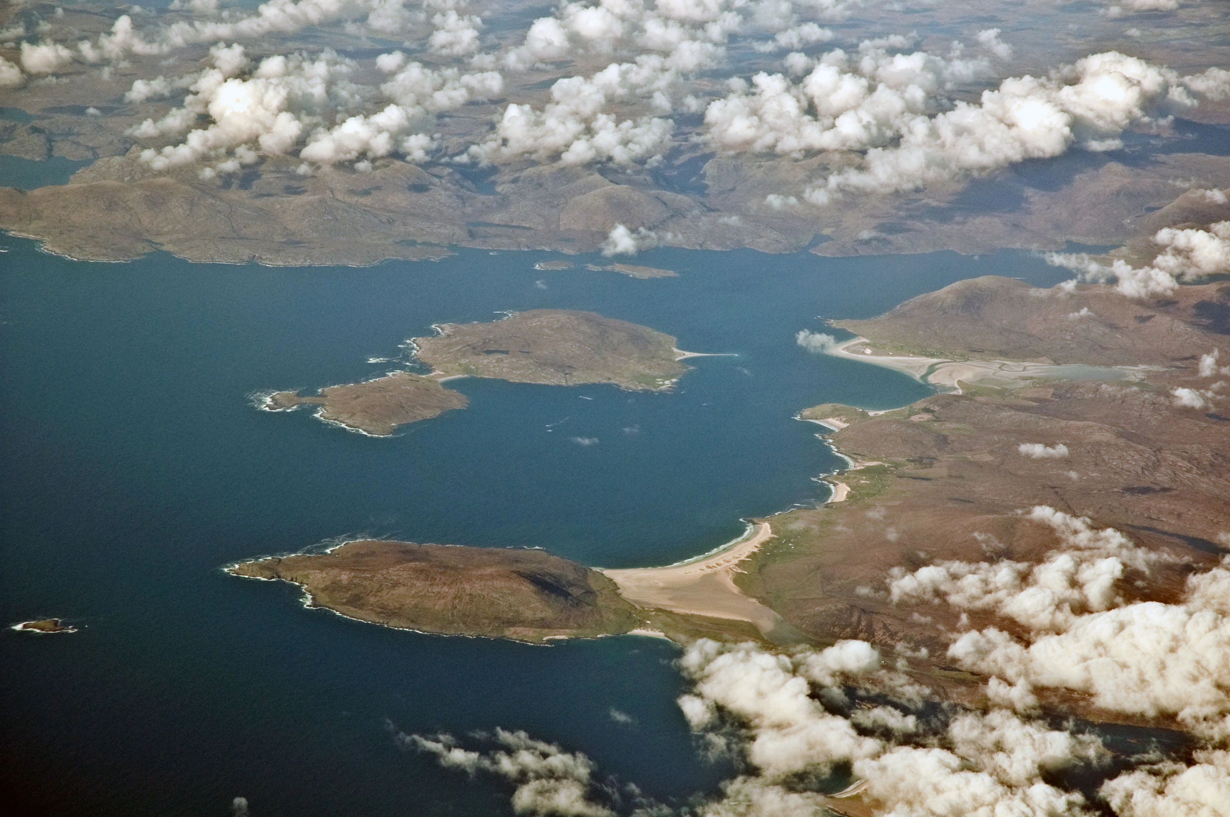
High-altitude aerial view of West Loch Tarbert in the Western Isles of Scotland, showing indented coastal islands, sandy shores, and surrounding rugged terrain partially obscured by scattered clouds.
An aerial view of West Loch Tarbert, illustrating the coastal landscape of the South Lewis, Harris and North Uist National Scenic Area.

South Lewis, Harris and North Uist National Scenic Area history and protected-area timeline

The origins of the designation lie in post-war concerns about Scottish landscape protection. After the Second World War, a committee chaired by Sir Douglas Ramsay was established to consider preservation of the Scottish landscape, and its 1945 report proposed that five areas, including Loch Lomond and the Trossachs, the Cairngorms, Glen Coe-Ben Nevis-Black Mount, Wester Ross, and Glen Strathfarrar-Glen Affric-Glen Cannich, should receive an additional level of planning protection. These became "national park direction areas", allowing central government review of local-authority planning decisions.

A further review of landscape protection in 1978 expanded this approach, identifying areas of exceptional scenic quality beyond the original five. The region that would become South Lewis, Harris and North Uist was among the new areas identified. In 1981, the earlier direction areas were replaced by the national scenic area designation, with this area included from the start. The boundary of the NSA remains as it was originally mapped in 1978.

In 2010, the area was redesignated under fresh legislation, formalising its modern status. There have since been calls for stronger protection: a proposal to create a national park on Harris was rejected by the Scottish Government in 2011, and the Scottish Campaign for National Parks included Harris among seven areas it recommended for national park status in 2013. In September 2016, Roseanna Cunningham, then Cabinet Secretary for Environment, Climate Change and Land Reform, told the Scottish Parliament that the Government had no plans to designate new national parks and intended to focus on the two existing national parks in Scotland.

Within the NSA, conservation history also includes the recognition of several Natura 2000 sites, with Special Protection Areas and Special Areas of Conservation designated for machair, montane habitats, blanket bog, the Grimersta salmon system, and Loch nam Madadh, reflecting an evolving understanding of the area's combined scenic and ecological value.

South Lewis, Harris and North Uist National Scenic Area landscape and geographic character

The landscape of the national scenic area is shaped by the meeting of ancient Lewisian gneiss mountains and a deeply indented Atlantic coastline. In North Harris, the terrain rises to Clisham at 799 metres, the highest peak in the Outer Hebrides, with steep-sided glens, precipitous crags, and exposed rocky faces giving the hills a distinctly mountainous character. Exposure to Atlantic weather, combined with historic grazing patterns, has kept the hills largely treeless, leaving open slopes of heather, rock, and montane vegetation.

Along the east of Harris, deep sea lochs penetrate far into the hills, producing a deeply cut shoreline of bays, headlands and small islets. The west side of Harris is gentler and more agricultural, with long, wide sandy beaches, dunes, and machair, the fertile coastal grassland that characterises much of the western Outer Hebrides. Between the beaches, rocky headlands stand as promontories, sculpted by the sea into geos, narrow cleft-like inlets, and isolated sea stacks.

South Lewis adds vast peatland, moorland, and a network of freshwater lochs and rivers. Loch Langavat and the Grimersta system cut through this terrain, creating contrasts of dark water and open moor. North Uist is defined by extensive low-lying peatland, intricate lochan systems, and unusually convoluted coastlines, including the fjardic sea loch of Loch nam Madadh, a sheltered inlet formed by glacial action rather than true fjord carving. The Sound of Harris separates these land masses with a scattering of low rocky and sandy islands, including Taransay, Pabbay and Berneray, extending the landscape outward into a wider seascape.
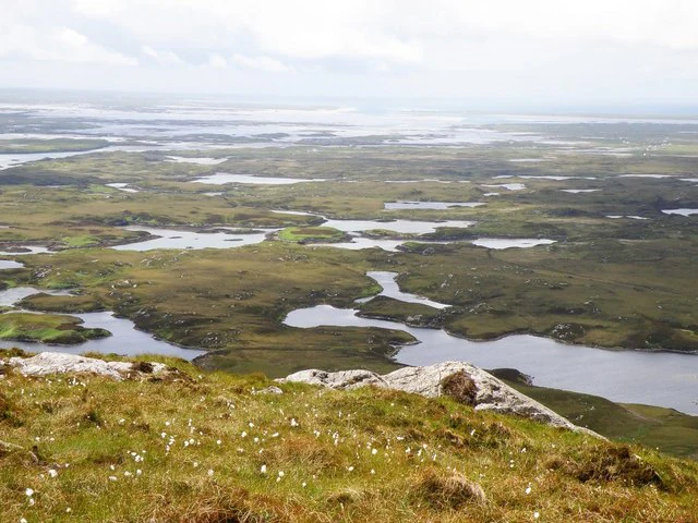
A high-angle view looking over a sprawling, boggy coastal landscape in North Uist, Scotland, characterized by numerous small lochs and rocky outcrops under an overcast sky.
A sweeping view across the expansive, water-dotted landscape of North Uist.

South Lewis, Harris and North Uist National Scenic Area ecosystems, habitats, and plant life

Ecologically, South Lewis, Harris and North Uist encompasses a remarkable range of habitats within a single continuous area. The mountains of North Harris support montane and upland heath communities, with thin soils and high exposure favouring specialised vegetation adapted to wind, rain, and short growing seasons. Below the montane zone, the hills grade into heather moorland and blanket bog, while valleys such as those around the Grimersta system add freshwater lochs, rivers, and salmon-bearing streams.

Along the west coast, machair grasslands form one of the most distinctive habitats in north-west Europe. The machair of North Uist is the second-largest area of machair in the Western Isles, and it differs from that of South Uist because a large proportion has traditionally been cultivated or used as rough pasture, producing a slightly different botanical mix. Inland, North Uist's deep peatlands support a particularly wide variety of vegetation, shaped by water levels, peat depth, and traditional land management.

The marine and intertidal habitats are equally important. Loch nam Madadh is a fjardic sea loch that is part of one of the most extensive and diverse water systems in Europe, with overlapping freshwater and saltwater influences. In some of its lagoons, freshwater organisms grow in a layer just above saltwater organisms, an unusual ecological arrangement. The marine zone of the NSA, extending below low tide, further extends the area's ecological character into deep and shallow waters around Harris, the Sound of Harris, and the waters adjacent to North Uist.

South Lewis, Harris and North Uist National Scenic Area wildlife and species highlights

Wildlife is a defining feature of the NSA, partly because the area's varied habitats support breeding populations of several species of conservation concern. The peatlands of Lewis, protected as a Special Protection Area, are designated for breeding black-throated divers, red-throated divers, dunlins, golden plovers, greenshanks and merlin, alongside golden eagles. North Harris is recognised for breeding golden eagles within both its montane heathland Special Area of Conservation and its Special Protection Area.

Mointeach Scadabhaigh, an area of blanket bog in South Uist that overlaps with related habitat in the NSA, hosts a productive breeding population of both red- and black-throated divers, including one of the highest-density red-throated diver populations in the United Kingdom. The machair of North Uist, including parts of outlying islands such as Berneray, Pabbay and Boreray, supports rich bird communities associated with cultivated coastal grasslands, while the surrounding waters and coastline provide habitat for seabirds, waders, and marine species.

The Grimersta river and loch system at Langavat in south Lewis is regarded as the best Atlantic salmon system in the Western Isles and is protected as a Special Area of Conservation, while Loch nam Madadh supports an unusual combination of intertidal plants and animals thanks to its layered freshwater and saltwater conditions. Together, these features give the area unusually high wildlife value for a landscape primarily designated for scenery.

South Lewis, Harris and North Uist National Scenic Area conservation status and protection priorities

The conservation significance of South Lewis, Harris and North Uist extends well beyond its scenic designation. Although the NSA itself provides a degree of protection through the planning system, the area also contains a network of Natura 2000 sites, with four Special Protection Areas and five Special Areas of Conservation either within or overlapping with the NSA. Four of these sites share both designations, although their precise borders differ.

These overlapping designations protect a range of high-value habitats: montane heathland and upland habitats in North Harris, machair grasslands and associated crofting landscapes in North Uist and outlying islands, blanket bog of a rare British type at Mointeach Scadabhaigh, freshwater lochs and rivers supporting salmon in south Lewis, and the unusual fjardic intertidal system of Loch nam Madadh. Together they recognise the area as one of international importance for birds, marine and freshwater species, and habitat conservation.

Because there is no equivalent of a national park authority managing the NSA, on-the-ground conservation relies on the wider framework of national and European designations, the local authority, Comhairle nan Eilean Siar, and NatureScot, which acts as the governing body listed for the area. Despite repeated calls, including proposals for national park status in 2011 and 2013, the Scottish Government has indicated that no new national parks are currently planned, leaving the existing NSA framework and the Natura 2000 designations as the principal long-term conservation instruments for the region.

South Lewis, Harris and North Uist National Scenic Area cultural meaning and human context

The cultural identity of South Lewis, Harris and North Uist is deeply woven into its landscape. The area lies at the heart of the Scottish Gaelic-speaking Outer Hebrides, and traditional crofting agriculture continues to shape land use, particularly on the machair coast of North Uist, where cultivation and rough pasture have long influenced habitat character. Place names throughout the area are predominantly Gaelic, with anglicised forms such as Lochmaddy reflecting the Scottish Gaelic Loch nam Madadh.

Fishing remains an important local activity, both creel fishing and aquaculture, with Lochmaddy acting as a harbour alongside its role as a ferry terminal linking the islands. Smaller inhabited islands such as Taransay and Berneray support long-standing communities, while more remote islets in the Sound of Harris are part of a wider cultural and seascape heritage of small-scale island settlement, navigation, and seasonal use. The combination of Gaelic language, crofting, fishing, and dispersed settlement is as much a part of what makes the area distinctive as its physical scenery.

Top sights and standout views in South Lewis, Harris and North Uist National Scenic Area

South Lewis, Harris and North Uist combines three contrasting scenic worlds into one continuous landscape: the mountains of North Harris with Clisham at their centre, the long machair beaches and rocky geos of the Atlantic coast, and the vast peatlands and intricate sea lochs of North Uist. The designation is unusual in being both the largest NSA in Scotland and the one with the greatest marine area, reflecting the inseparable nature of land and seascape in the Outer Hebrides.

Within this framework, key points of distinction include the Sound of Harris with its scattered islands, the Grimersta salmon system on Lewis, the machair of North Uist, and the fjardic sea loch at Loch nam Madadh. The area's status as a working cultural landscape, shaped by Gaelic language, crofting and fishing, adds a human dimension that complements its scenic and ecological importance.

Best time to visit South Lewis, Harris and North Uist National Scenic Area

The area's scenery changes with the seasons, and the best time to visit depends largely on what visitors hope to experience. Late spring and summer bring the longest daylight hours, the brightest colours on the machair, and the most active period for breeding birds, including the divers, golden eagles, and waders that the area's conservation designations seek to protect. Summer is also when the ferry services and small island communities are most accessible, and when crofting and fishing activity is at its busiest.

Spring and early autumn offer quieter conditions, often with dramatic skies over the Atlantic coast, fewer visitors, and a more contemplative feel across the mountains and peatlands. Winter brings short days, frequent Atlantic weather systems, and a more austere beauty, but also potential disruptions to ferry crossings and remote-island access. For those primarily interested in bird life, the breeding season is the strongest focus, while those drawn to landscape and photography may prefer the angled light and shifting weather of the shoulder seasons.
Monthly climate preview

Long-term representative point measurements tracking annual temperature and precipitation rhythms

South Lewis, Harris and North Uist National Scenic Area Climate Normals and Weather by Month

Representative coordinate records show average monthly temperatures ranging from 6.21 °C to 13.8 °C alongside varying precipitation rates across the twelve-month cycle. Detailed monthly climate normals provide broader analytical context for understanding long-term environmental patterns across the protected landscape.
Annual mean10 °C
6 °C14 °C
Jan
Feb
Mar
Apr
May10°
Jun12°
Jul13°
Aug14°
Sep13°
Oct11°
Nov
Dec
Warmest month
August

13.8 °C

Coolest month
February

6.2 °C

Wettest month
January

5.3 mm/day

Driest month
May

2.7 mm/day

Park location guide

Geography guide, regional context, and park location map for South Lewis, Harris and North Uist National Scenic Area

South Lewis, Harris and North Uist National Scenic Area park geography, regions, and map view in United Kingdom

Understand where South Lewis, Harris and North Uist National Scenic Area sits in United Kingdom through a broader geographic reading of the surrounding landscape, nearby location context, and its mapped position within the national park landscape.

How South Lewis, Harris and North Uist National Scenic Area fits into United Kingdom

The United Kingdom is a parliamentary constitutional monarchy located in northwestern Europe, consisting of four constituent countries: England, Scotland, Wales, and Northern Ireland. As a major global power with over 69 million residents, it maintains significant international influence in politics, economics, and culture.

Wider geography shaping South Lewis, Harris and North Uist National Scenic Area in United Kingdom

The United Kingdom is an island nation located in northwestern Europe, surrounded by the Atlantic Ocean, North Sea, English Channel, Celtic Sea, and Irish Sea. It shares a land border with the Republic of Ireland to the west. The territory includes the island of Great Britain, the northeastern portion of Ireland, and most of the smaller British Isles islands.

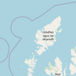
Map view of South Lewis, Harris and North Uist National Scenic Area

Use this park location map to pinpoint South Lewis, Harris and North Uist National Scenic Area in United Kingdom, understand its exact geographic position, and read its mapped placement within the surrounding landscape more clearly.

Pigeon | © OpenStreetMap contributors

Location context for South Lewis, Harris and North Uist National Scenic Area

ScotlandWestern Isles

Visualizing the mountains, machair beaches, and sea lochs of the Outer Hebrides

South Lewis, Harris and North Uist National Scenic Area Photos and Landscapes

Visual records illustrate the rugged terrain, marine ecosystems, and protected coastal habitats defining South Lewis, Harris and North Uist National Scenic Area. Examining photographic evidence reveals the scale of the mountainous interior, expansive peatlands, and intricate Atlantic shorelines across the northern islands.

High-altitude aerial view of West Loch Tarbert in the Western Isles of Scotland, showing indented coastal islands, sandy shores, and surrounding rugged terrain partially obscured by scattered clouds.

A wide coastal landscape in South Harris, Scotland, showing dark rocky foreground, turquoise sea with gentle waves, a curved sandy beach, and rolling green hills under a cloudy sky. Two people are standing on the rocks, one with a tripod.

A high-angle view looking over a sprawling, boggy coastal landscape in North Uist, Scotland, characterized by numerous small lochs and rocky outcrops under an overcast sky.

Park atlas

Explore surrounding regional landscapes and connected Atlantic protected areas

Parks Near South Lewis, Harris and North Uist National Scenic Area

Compare adjacent protected areas and regional reserves extending across the Scottish islands. Expanding the geographical view helps evaluate neighboring coastal terrain, peatlands, and marine sanctuaries.
A watercolor painting showing a soft landscape featuring purple mountains in the background, a line of green evergreen trees, and a river winding through a grassy plain under a light sky.
Nature reserveOuter Hebrides
About 34 km away#1 closest

Southwest

Monach Islands Nature Reserve: Atlas Overview of Outer Hebrides Coastal Landscapes

Mapped protected areas and machair grassland geography

The Monach Islands consist of three main islands linked by tidal flats, creating a dynamic environment shaped by coastal erosion and maritime forces. As a protected nature reserve, the islands are vital for understanding rare machair habitats and the marine geomorphology of the Outer Hebrides, serving as a critical refuge for seabirds and thousands of breeding grey seals.

Area
5.981 km²
IUCN
IV
Relief
Lowland
Climate
Temperate
Protected landscapeHighland
About 48 km away#2 closest

East

Trotternish National Scenic Area: A Geographic Atlas of the Isle of Skye Protected Landscape

Basalt escarpments and geologic landmarks in the Scottish Highlands

Trotternish National Scenic Area features a long, continuous basalt escarpment that defines the spine of northern Skye. This protected landscape contains complex ridge formations, dramatic coastal cliffs, and a rich record of Jurassic geology. Learn about the physical geography, mapped extent, and natural terrain that make this region a key protected area within the Highland geography of Scotland.

Established
1981
Relief
Upland
Climate
Temperate
Access
Moderate access
A pale, minimalist watercolor painting showing gentle hills, a curved shoreline, and sparse grass against a white background.
Protected areaNa h-Eileanan Siar
About 65 km away#3 closest

Northeast

Isle of Lewis Protected Area: Geography, Coastal Landscapes, and Highland Terrain

Mapped regional geography of the Outer Hebrides

The Isle of Lewis represents a significant protected landscape defined by its ancient geological roots and diverse coastal ecosystems. From the lime-rich machair grasslands of the west to the deeply indented sea lochs of the east, this area offers a unique perspective on the physical geography and inland peatland networks of the North Atlantic.

Area
1,770 km²
Visitors
219K annual
Relief
Mixed relief
Climate
Temperate
Watercolor painting of a coastal landscape with distant mountains, a rocky shoreline, and light foreground vegetation on a white background.
Protected landscapeHighland
About 92 km away#4 closest

Southeast

Small Isles Protected Landscape: Atlas of the Highland Inner Hebrides Archipelago

Mapped terrain, volcanic geology, and coastal protected areas.

Delve into the geography of the Small Isles, a protected landscape encompassing Rùm, Eigg, Canna, and Muck. This atlas entry provides a structured look at the volcanic peaks, maritime skerries, and diverse land-stewardship boundaries that define this remote Scottish archipelago.

Area
472.35 km²
Established
1981
Relief
Mountain
Climate
Temperate
Marine protected areaHighland
About 96 km away#5 closest

Southeast

Loch Alsh Nature Conservation Marine Protected Area: Geography and Protected Boundaries

A vital Highland marine landscape featuring rare underwater flame shell colonies.

Loch Alsh sits as a distinct marine boundary in the Northwest Highlands of Scotland. This protected area safeguards a vast seafloor ecosystem, most notably a massive flame shell colony that has transformed local understanding of marine biodiversity in the region. The loch landscape blends ancient metamorphic geology with the fjord-like waters separating Skye from the mainland, offering a unique perspective on protected coastal terrains.

Area
0.75 km²
Established
2014
Relief
Mountain
Climate
Temperate
A soft, impressionistic watercolor painting of a Scottish loch surrounded by rolling green hills and distant mountain silhouettes.
Marine protected areaRoss and Cromarty
About 99 km away#6 closest

East

Loch Carron Marine Protected Area: Coastal Geography and Protected Seabed Landscape Atlas

Exploring the tidal basins and underwater terrain of Ross and Cromarty.

Loch Carron stands as a landmark marine protected area defined by its dramatic underwater depth changes and robust tidal currents. This protected sea loch features the world's largest flame shell colony nestled beneath the cliffs at Strome Castle. The surrounding Highland geography of Ross and Cromarty creates a compressed, mountain-framed landscape that influences the rich ecological character of this essential coastal habitat.

Area
23 km²
Established
2019
Relief
Lowland
Climate
Temperate
Protected landscapeHighland
About 110 km away#7 closest

East

Wester Ross National Scenic Area: Protected Highland Mountain and Coastal Landscape Atlas

Geographic mapping of the Northwest Highlands terrain

Wester Ross National Scenic Area spans vast stretches of the Northwest Highlands, characterized by towering Torridonian sandstone peaks and deeply carved sea lochs. This protected region integrates ancient Scots pine forests, glacial-carved glens, and complex coastal environments into one of the most recognizable geographic features of Scotland. The landscape serves as a vital record of geological heritage and high-latitude biodiversity within the Highland administrative region.

Area
1,634.58 km²
Established
1981
Visitors
70K annual
Relief
Mountain
Protected landscapeHighland
About 128 km away#8 closest

Southeast

Morar, Moidart and Ardnamurchan National Scenic Area: Coastal Geography and Protected Lands

A mapped overview of peninsulas, lochs, and Highland terrain

Investigate the protected landscape of Morar, Moidart and Ardnamurchan. This area combines dramatic basalt cliffs, silver sands, and significant historical sites within a remote maritime setting. Gain clarity on the overlapping conservation zones and the complex geography that shapes this distinctive Scottish coastal region.

Area
369.6 km²
Established
1981
Relief
Mixed relief
Access
Moderate access

Common questions about visiting, size, designation, and location context for South Lewis, Harris and North Uist National Scenic Area

South Lewis, Harris and North Uist National Scenic Area FAQs for park facts, access, geography, and protected area context

Find quick answers about South Lewis, Harris and North Uist National Scenic Area, including protected-area facts, park geography, trail and visitor context, and how the park fits into its surrounding country and regional landscape.
MoriAtlas Explorer

Continue Your Protected Areas Search Across the Global Atlas

Deepen your exploration by continuing the structured search for national parks and protected areas worldwide. Utilize the comprehensive filtering capabilities to compare different conservation landscapes and refine your understanding of global park geography. Discover more about the distribution and characteristics of protected natural areas.

Global natural geography