
Mori Atlas logo
Nature reserveSpargründe bei Dohna

Tracing the deep ravines and crystalline geological formations of this protected Saxon valley landscape

Spargründe bei Dohna Nature Reserve: Geographic Map and Protected Valley Landscape Analysis

(Naturschutzgebiet Spargründe bei Dohna)

Spargründe bei Dohna represents a unique nature reserve in the Sächsische Schweiz-Osterzgebirge district of Germany, characterized by its sharp incisions into the surrounding granodiorite bedrock. The protected area consists of parallel valley systems including the Spargrund and Kleiner Spargrund, where dense beech and oak forests frame steep rocky slopes and quiet brookland. This detailed geographic record provides context on the structural boundaries and natural terrain of these ravines located near the Müglitz river corridor.

nature reservevalley landscaperocky ravinedeciduous forestbeech forestoak forest
A flat-style digital illustration of a scenic valley featuring a large waterfall flowing into a river, surrounded by pine trees and steep rocky cliffs under a soft sun.

Spargründe bei Dohna

Nature reserve

Park overview

Structured park overview, official facts, and landscape profile for Spargründe bei Dohna

Spargründe bei Dohna park facts, protected area profile, and essential visitor context

Review the core facts for Spargründe bei Dohna, including designation, size, terrain, visitor scale, habitats, and operating context in one park-focused overview.

About Spargründe bei Dohna

Spargründe bei Dohna is a compact nature reserve in eastern Saxony, defined by two narrow, mostly parallel valleys that open westward from the Müglitz valley. The protected zone comprises the Spargrund and the smaller Kleiner Spargrund, with the Schindergraben as the brook running through the latter, while the Sürßengrund adds an additional smaller valley area to the north. Altogether about 37 hectares of rugged valley landscape near Dohna are managed for nature conservation, and the reserve forms one of several Naturschutzgebiete within the Landkreis Sächsische Schweiz-Osterzgebirge.

The valleys lie on the western side of the Müglitz river, immediately opposite the historic core of Dohna. Their lower entrances are partially obscured by the embankment of the Müglitztalbahn railway, which was rerouted onto the western valley slope in the 1930s; in this section the Sürßenbach and Spargrundbach now run underground to their confluence with the Müglitz. Where the terrain opens up, the two brooks join between the rocky ridge of Vogelherd and a rocky spur that historically yielded granodiorite for construction.

The slopes of the Spargründe carry dense, largely shaded deciduous high forest dominated by beech and oak along the lower and middle valley sections. In the upper reaches the canopy thins, and narrow valley floodplains support a more diverse ground vegetation alongside the small streams. The Sürßengrund portion is partially followed by a local country road, while most of the Sürßenbach valley remains unaccompanied by formal paths, running between fields and orchards outside the village of Sürßen before reaching the protected area. Hiking trails with resting benches, information boards, and viewpoints such as the nearby Pilz overlook tie the reserve into the broader recreational landscape around Dohna and the Müglitz valley.

Quick facts and research context for Spargründe bei Dohna

The Spargründe bei Dohna is a protected nature reserve, formally designated as a Naturschutzgebiet in the district of Sächsische Schweiz-Osterzgebirge in Saxony, Germany. It covers around 37.3 hectares and lies on the western side of the Müglitz valley directly opposite the settlement area of Dohna. The reserve includes the two main valleys of Spargrund and Kleiner Spargrund, as well as the adjoining Sürßengrund to the north. Geologically, the area belongs to the northern margin of the Elbtalschiefergebirge and is shaped by the Cadomian-age Dohna Granodiorite. The site overlaps with the FFH area Müglitztal, tying the small valley reserve into the larger Natura 2000 network along the Müglitz river.

Protection and recognition

Analysis of terrestrial protected area designation and management boundaries

Spargründe bei Dohna Protection Status and Documented Conservation Scope

Spargründe bei Dohna maintains a strictly terrestrial protection scope within its designated conservation boundaries. Documented records provide comprehensive baseline facts regarding administrative status and international recognition frameworks.

Protection details

Protection scope
Terrestrial
Transboundary protection
No
Park context

Deeper park guide and search-rich context for Spargründe bei Dohna

Spargründe bei Dohna history, landscape, wildlife, and travel context

Explore Spargründe bei Dohna through its history, landscape character, ecosystems, wildlife, conservation priorities, cultural context, and seasonal travel timing in a structured park guide built for atlas discovery and search intent.

Why Spargründe bei Dohna stands out

The Spargründe bei Dohna is best known for its deeply cut, parallel forest valleys with steep rocky flanks of reddish-gray Dohna Granodiorite. The reserve exemplifies the small-scale, gorges-like valley landscapes typical of the northern edge of the Saxon Elbtalschiefergebirge, where narrow streams have incised sharp ravines into crystalline bedrock. Walking visitors encounter dark beech and oak forest along the lower valley slopes, scattered block fields, and quiet brookland in the upper valleys, making the area a representative example of Saxon mid-mountain valley nature close to Dohna.
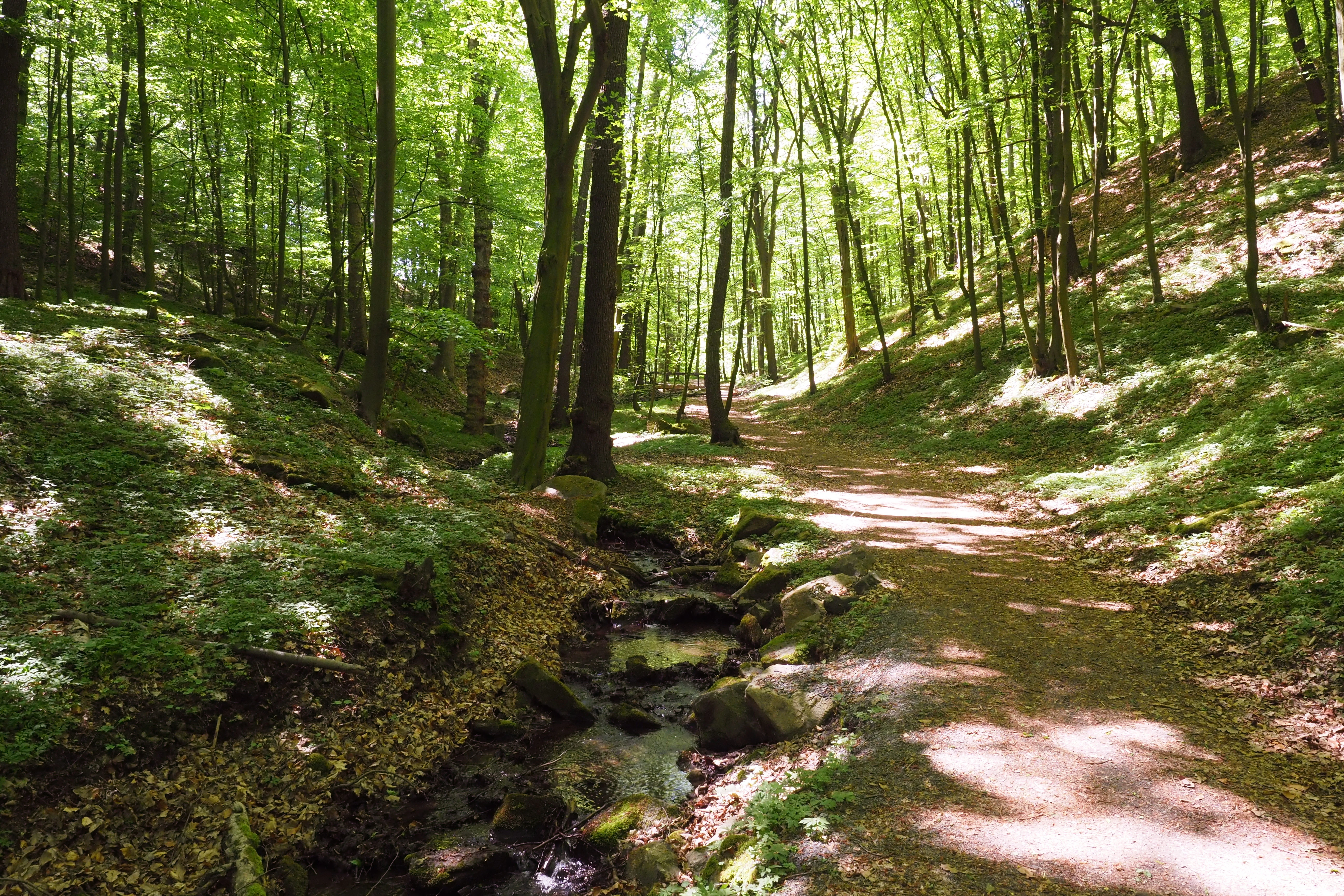
A dirt hiking path running alongside a small, shallow stream through a sunlit, green forest with tall deciduous trees.
A shaded hiking trail follows a small creek through the dense deciduous forest of the Spargründe bei Dohna nature reserve.

Spargründe bei Dohna history and protected-area timeline

The Spargründe bei Dohna is a designated Naturschutzgebiet, established within the framework of Saxon nature protection law, and the area has long been recognized locally as a distinctive landscape feature near Dohna. A 1965 volume in the 'Werte der Deutschen Heimat' series dedicated a section to the Spargrund, indicating that the valley was already appreciated as a notable piece of regional heritage during the mid-20th century.

A key historical influence on the visible character of the reserve came in the 1930s, when the Müglitztalbahn railway was relocated from the valley floor onto the western slope of the Müglitz. This rerouting buried parts of the Sürßenbach and the Spargrundbach underground beneath the rail embankment, reshaping how the lower valley entrances appear today. Earlier, small-scale quarrying of the local Dohna Granodiorite had taken place on one of the rocky spurs bounding the valleys, leaving the scattered block fields of broken stone that still mark parts of the slopes today.

Spargründe bei Dohna landscape and geographic character

The landscape of the Spargründe bei Dohna is shaped by sharply incised, narrow valleys cutting into the northern margin of the Elbtalschiefergebirge. The Spargrund winds between partially rocky slopes, expanding in its middle course into a steep-sided section that forms the boundary between Dohna and the neighboring municipality of Müglitztal, while the Kleiner Spargrund runs almost straight from west-southwest toward the Müglitz. Where the valleys meet, the rocky ridge Vogelherd and a second blocking ridge frame the confluence of the Spargrundbach with the Schindergraben.

The underlying geology is dominated by the Dohna Granodiorite, a Cadomian-age, reddish to gray, predominantly medium-grained leucocratic granite-type rock that emerges in exposed cliffs and scattered boulder fields along the slopes. Crystalline basement rocks in this area are relatively low in groundwater because the granodiorite shows few open fractures, giving the valleys their visually dry, rocky character above the brook level.
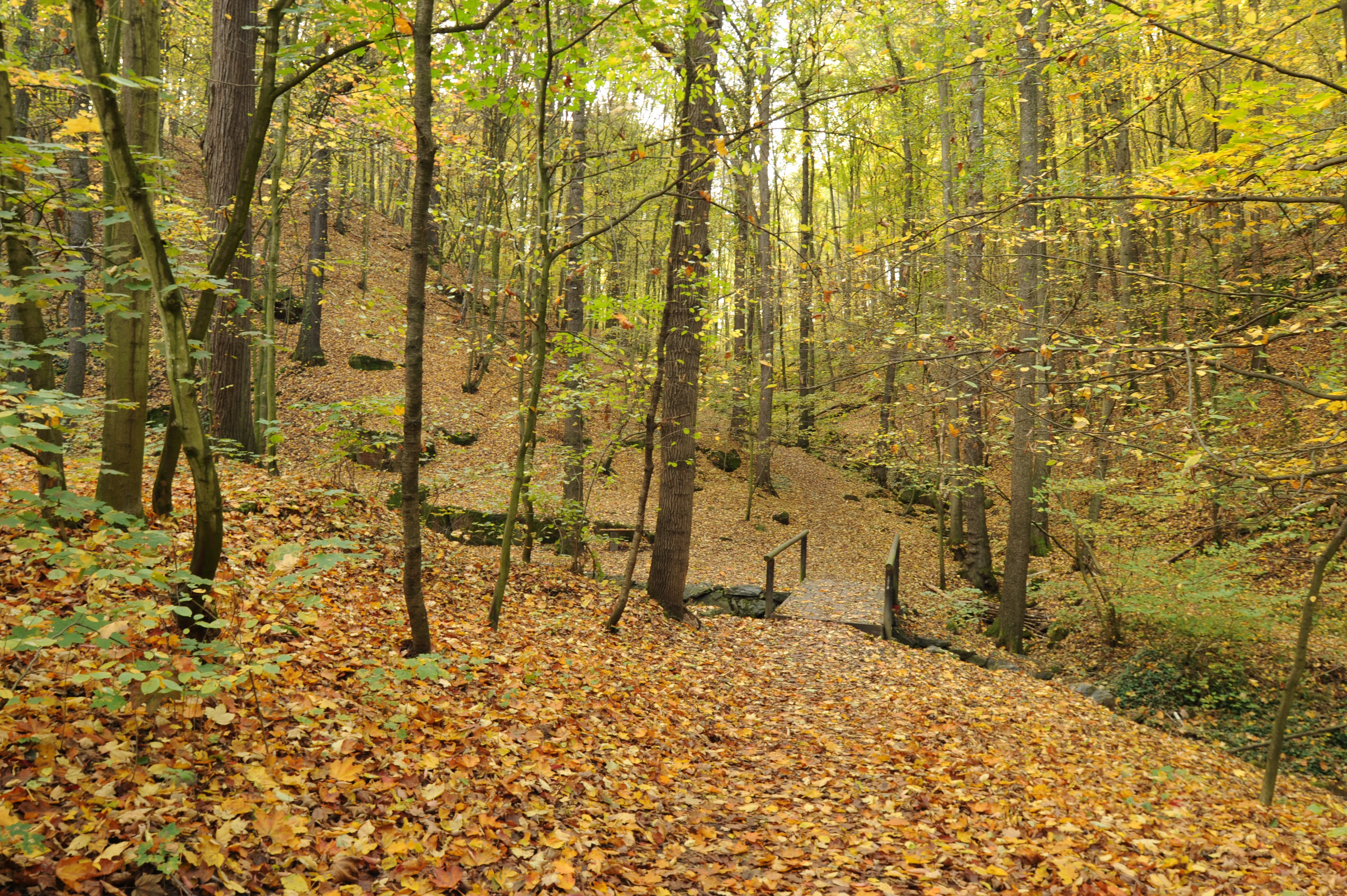
A forest path covered in fallen autumn leaves leads to a small footbridge over a stream in a wooded valley.
A wooded valley trail during autumn in Spargründe bei Dohna, featuring a small bridge crossing a creek.

Spargründe bei Dohna ecosystems, habitats, and plant life

Ecologically, the Spargründe bei Dohna is dominated by closed, shady deciduous forest along the lower and middle slopes, with beech and oak forming the main canopy. The forest creates a dark, humid valley atmosphere that contrasts with the more open slopes and the narrow valley floors higher up. As elevation within the valleys increases, the canopy lightens and the small floodplains beside the brooks support a more varied ground flora, characteristic of small mid-mountain stream valleys in Saxony.

The reserve sits within the FFH area Müglitztal, embedding its forest and brook habitats into a larger Natura 2000 network across the Müglitz river corridor. The juxtaposition of dense mature forest, rocky outcrops, small valley meadows, and minor watercourses provides a compact mosaic of forest and valley habitats in a relatively small area, contributing to habitat continuity along the Müglitz.
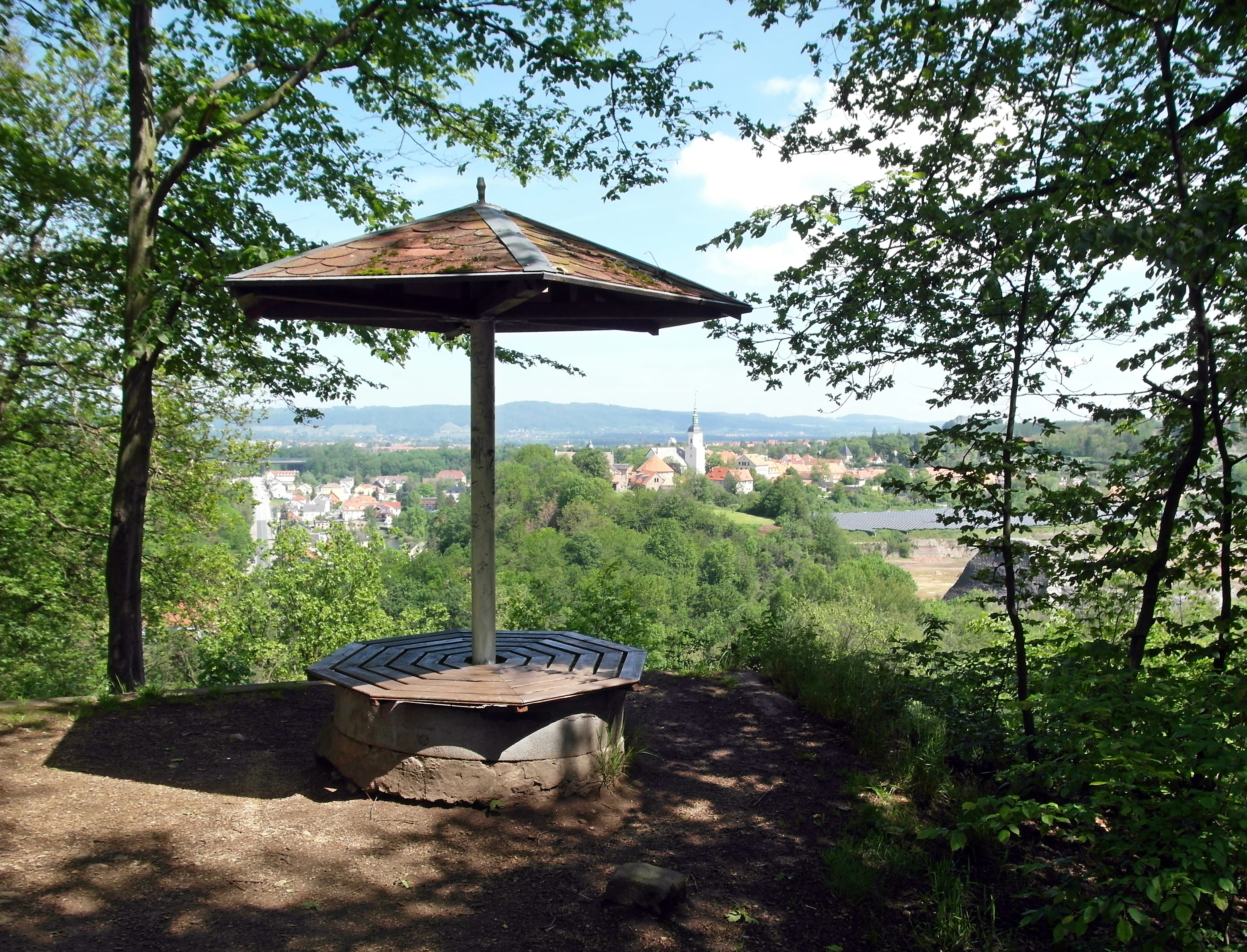
A wooden shelter with a central pillar and octagonal seating sits on a hillside overlooking a town with a prominent church steeple and distant hills.
A view of the town of Dohna from the Pilz viewpoint, located near the Spargründe bei Dohna nature reserve.

Spargründe bei Dohna wildlife and species highlights

The wildlife profile of the Spargründe bei Dohna is closely tied to its shaded, mature beech and oak forest and its cool, humid valley climate. Such conditions support typical forest-dwelling invertebrates, small mammals, and forest birds associated with old broadleaf stands in the Saxon mid-mountains. The brooks running through the narrow valley floors, although partially channeled underground in their lower courses, still provide riparian habitat along the protected sections.

The reserve's significance for fauna is amplified by its position inside the Müglitztal FFH area, where forest and stream habitats connect with the broader landscape of the Müglitz valley. While detailed species inventories are not the focus of the available sources, the structural combination of mature broadleaf canopy, rocky outcrops, and small streams offers nesting and shelter conditions valued by woodland birdlife and other forest fauna typical of the eastern Erzgebirge foothills.
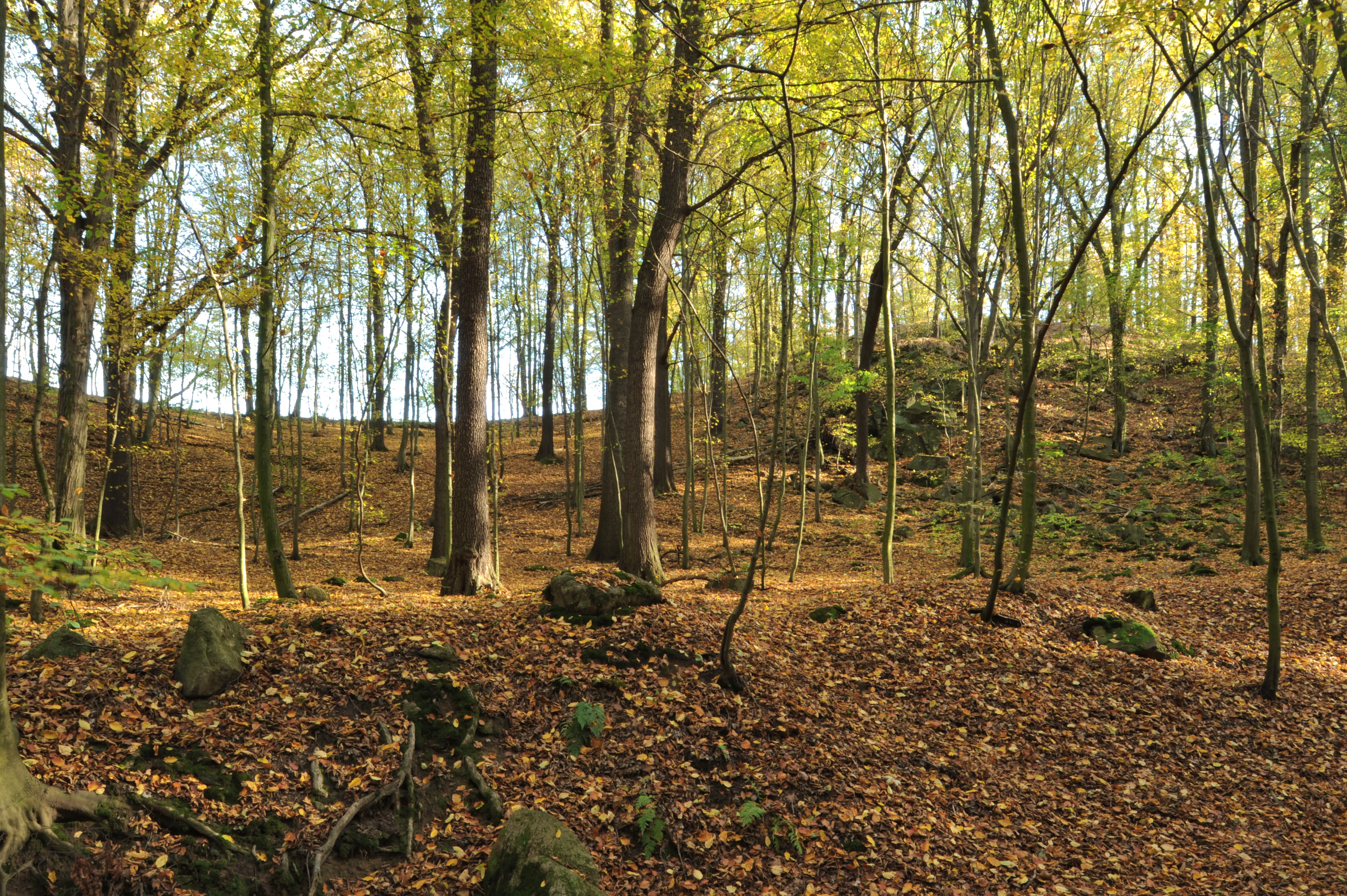
A forest floor covered in fallen autumn leaves with scattered rocks and boulders under a canopy of yellowing trees.
Autumn foliage and rock debris scattered on the slopes of the Spargründe valley.

Spargründe bei Dohna conservation status and protection priorities

The Spargründe bei Dohna is protected as a Naturschutzgebiet under Saxon nature conservation law, covering roughly 37 hectares of valley landscape west of Dohna. Its designation reflects the value of the area's narrow, rocky, forest-filled valleys as a representative example of Saxon mid-mountain valley nature, with the Dohna Granodiorite bedrock, the beech-oak forest stands, and the small tributary streams together forming the conservation focus.

Inclusion of the site in the FFH area Müglitzal raises its protection profile beyond purely national-level nature reserve status, integrating habitat conservation here with the larger European network along the Müglitz river. By safeguarding forest cover, rocky habitat structures, and stream-side vegetation in close proximity to Dohna, the reserve helps maintain landscape connectivity, protects local geomorphological features, and buffers habitat pressures along a heavily used regional river valley.

Spargründe bei Dohna cultural meaning and human context

The Spargründe bei Dohna sits in a region with a long tradition of valuing its small valley landscapes as part of local cultural heritage. A 1965 publication in the 'Werte der Deutschen Heimat' book series, dedicated to the area around Pirna, devoted a section specifically to the Spargrund, framing the valley as a recognized element of regional identity. Local cultural practices, including walking and small-scale quarrying of the Dohna Granodiorite, have historically shaped both the physical and the symbolic character of these valleys.

Today, the reserve is closely tied to the town of Dohna, whose tourism materials list the Spargründe among recommended hiking destinations and whose viewpoints, such as the Pilz, offer framed vistas toward the town and castle. The valleys thus blend ecological protection with regional recreational culture at the northern edge of the Saxon Switzerland-Osterzgebirge district.

Top sights and standout views in Spargründe bei Dohna

Key highlights of the Spargründe bei Dohna include the paired, almost parallel valley incisions of the Spargrund and the Kleiner Spargrund with the Schindergraben, the steep rocky slopes around the granite ridge Vogelherd, and the dense beech-oak forest that shades the lower valley. The Sürßengrund adds a quieter, partly agricultural counterpart with a small brook running from the village of Sürßen toward the Müglitz. Walking infrastructure, including marked trails, information boards, and the nearby viewpoint Pilz with views back to Dohna, makes the compact reserve a readily accessible introduction to the valley landscapes at the edge of the Saxon Switzerland region.

Best time to visit Spargründe bei Dohna

The Spargründe bei Dohna shows its most atmospheric character in late spring and early summer, when the beech and oak canopy has fully leafed out and the small valley brooks carry more water, deepening the shaded, cool ambiance of the ravines. Autumn is also rewarding, with leaf color across the broadleaf forest and softer light penetrating the rocky slopes, while the open sections of the Sürßengrund remain accessible between fields and orchards. Winter visits are possible on the established footpaths, though fallen leaves can hide some rocky ground, and snow or frost can emphasize the contrast between dark forest, bare granite, and the pale block fields along the slopes.

Monthly climate preview

Long-term monthly temperature and precipitation patterns sampled from representative park coordinates

Spargründe bei Dohna Climate Normals and Annual Temperature Rhythm

Spargründe bei Dohna exhibits a measured annual cycle of temperature and precipitation based on long-term climatology records from representative coordinates. Reviewing the complete monthly profile provides deeper clarity into the multi-year temperature ranges and precipitation rates recorded across the terrain.
Annual mean8 °C
-2 °C19 °C
Jan-2°
Feb-1°
Mar
Apr
May13°
Jun17°
Jul19°
Aug19°
Sep14°
Oct
Nov
Dec-1°
Warmest month
July

19.1 °C

Coolest month
January

-1.8 °C

Wettest month
July

2.8 mm/day

Driest month
April

1.3 mm/day

Park location guide

Geography guide, regional context, and park location map for Spargründe bei Dohna

Spargründe bei Dohna park geography, regions, and map view in Germany

Understand where Spargründe bei Dohna sits in Germany through a broader geographic reading of the surrounding landscape, nearby location context, and its mapped position within the national park landscape.

How Spargründe bei Dohna fits into Germany

Germany is a federal republic in Western and Central Europe with a population of over 83 million across sixteen constituent states. It is Europe's largest economy by nominal GDP and a major global exporter and importer. The capital is Berlin, and the country borders Denmark, Poland, Czech Republic, Austria, Switzerland, France, Luxembourg, Belgium, and the Netherlands.

Wider geography shaping Spargründe bei Dohna in Germany

Germany is located in Western and Central Europe, spanning 357,022 km². It borders Denmark to the north, Poland and the Czech Republic to the east, Austria and Switzerland to the south, and France, Luxembourg, Belgium, and the Netherlands to the west. The country has coastlines on the Baltic Sea and North Sea to the north, with the Alps located in the southern region.

Map view of Spargründe bei Dohna

Use this park location map to pinpoint Spargründe bei Dohna in Germany, understand its exact geographic position, and read its mapped placement within the surrounding landscape more clearly.

Pigeon | © OpenStreetMap contributors

Location context for Spargründe bei Dohna

Saxony

Explore the rocky ravines, granodiorite outcrops, and forest valleys of the protected nature reserve.

Spargründe bei Dohna Photos and Landscape Scenery Visual Archive

Visual documentation captures the sharply incised valley terrain, dense beech-oak forests, and exposed rock formations defining the protected area. Photographic records reveal the distinct geological character and narrow ravine habitats unique to the Saxon mid-mountain landscape.

A dirt hiking path running alongside a small, shallow stream through a sunlit, green forest with tall deciduous trees.

A dirt hiking trail covered in autumn leaves leads through a wooded gorge flanked by tall, moss-covered sandstone cliffs.

A forest path covered in fallen autumn leaves leads to a small footbridge over a stream in a wooded valley.

A wooden shelter with a central pillar and octagonal seating sits on a hillside overlooking a town with a prominent church steeple and distant hills.

A forest floor covered in fallen autumn leaves with scattered rocks and boulders under a canopy of yellowing trees.

A forest landscape with a small stream flowing over moss-covered stones in the Spargründe valley, with a small wooden bench positioned on the slope.

Park atlas

Compare nearby valley reserves and regional protected terrain across the Saxon border.

Exploring Parks Near Spargründe bei Dohna and Surrounding Protected Landscapes

Continue browsing other parks near Spargründe bei Dohna to discover similar incised valley formations and rocky forest ravines. Expanding the geographic scope reveals connected conservation corridors throughout the surrounding regional terrain.
A pale, soft watercolor illustration showing a horizontal landscape of light green trees, shrubs, and rolling grassy plains on a white background.
Nature reserveGermany
About 6.1 km away#1 closest

North

Elbinseln Pillnitz und Gauernitz: A Study in Protected Saxon River Landscapes

Examining floodplain geography and rare river island ecosystems

Located in the Elbe valley between Dresden and Meissen, Elbinseln Pillnitz und Gauernitz preserves the final natural river islands within the state of Saxony. This protected nature reserve anchors a vital network of alluvial soils, riparian woodlands, and unarmored riverbanks, offering a unique perspective on the dynamic floodplain geography of Germany's major river corridors.

Area
0.235 km²
Established
2006
IUCN
IV
Relief
Lowland
Watercolor painting of a soft landscape featuring distant hills and foreground vegetation in shades of green, yellow, and soft red.
Nature reserveSachsen
About 6.7 km away#2 closest

North

Dresdner Elbtalhänge Nature Reserve: Geography, Mapped Boundaries, and Landscape Context

An essential nature reserve along the Elbe valley in Sachsen

Dresdner Elbtalhänge captures the striking transition between the flat Elbe floodplain and the Westlausitz hill region. This detailed atlas entry covers the reserve's unique geomorphology, including its incised ravine systems, south-facing oak forests, and exposed rock formations that define its protected character within Sachsen.

Area
203.6 km²
Established
2007
IUCN
IV
Watercolor painting showing a landscape with green hills, trees, and a river winding through the scene
National parkGermany
About 12 km away#3 closest

East

Saxon Switzerland National Park: Protected Area Geography and Map Exploration

Discover its mapped boundaries and regional landscape context.

Saxon Switzerland National Park, a protected national park in Germany, offers a distinct focus for geographic and atlas-based discovery. This page details the park's specific protected landscape, its mapped boundaries, and its contribution to the regional geography. MoriAtlas allows for in-depth exploration of such natural areas, providing essential context for understanding their place within broader natural systems and mapped terrains.

Area
93.5 km²
Established
1990
IUCN
II
Visitors
1.7M annual
Nature reserveFreistaat Sachsen
About 14 km away#4 closest

West

Windberg Nature Reserve: Mapping the Forested Ridge and Protected Landscape of Saxony

Geology, mining heritage, and protected oak-beech forest ecosystems

Windberg serves as the prominent local landmark for Freital, defined by its elongated forested plateau and complex tectonic geography. This nature reserve offers a study in the intersection of environmental conservation and human industrial history, featuring Saxony's deepest cave and varied habitats within the eastern Ore Mountains foothills.

Established
1967
Relief
Mountain
Climate
Temperate
Access
Easy access
Nature reserveSächsische Schweiz-Osterzgebirge
About 17 km away#5 closest

South

Weicholdswald Nature Reserve: Mapped Protected Landscapes of the Eastern Ore Mountains

A preserved beech forest enclave within the Sächsische Schweiz-Osterzgebirge

Weicholdswald stands as a primary nature reserve in the Sächsische Schweiz-Osterzgebirge district, known for its 160-year-old beech trees and extensive deadwood habitats. This protected area provides a rare look at near-natural forest ecosystems that have remained free from historic clear-cutting or coniferous monocultures, maintaining rich biodiversity across its streams and granitic slopes.

Area
1.037 km²
Established
1961
IUCN
IV
Nature reserveSaxony
About 20 km away#6 closest

West

Weißeritztalhänge Nature Reserve: Protected Slope Forests and River Valley Geography

Regional landscape profile in Saxony, Germany

Weißeritztalhänge represents a significant nature reserve situated along the Wilde Weißeritz in Saxony. The protected area features expansive slope forests that transition from the Saxon lowlands into the Erzgebirge, providing a critical refuge for diverse woodland and river-dwelling species.

Area
4.486 km²
Established
1961
IUCN
IV
Relief
Upland
A soft watercolor illustration of a bog landscape with a dark central pool, surrounding marsh vegetation, and distant pale hills.
Nature reserveÚstecký kraj
About 20 km away#7 closest

Southeast

Rájecká rašeliniště Nature Reserve: Protected Peatland and Sandstone Geography in Ústecký kraj

Geographic atlas and protected area landscape summary

Rájecká rašeliniště serves as a critical study in landscape ecology, featuring rare peat-forming vegetation located within the high-relief sandstone formations of the Ústecký kraj. This protected nature reserve provides a unique look at how specialized bog communities thrive despite the porous, water-draining characteristics of the local sandstone terrain, highlighting the site's importance within the Czech conservation landscape.

Area
0.017 km²
Established
2004
IUCN
IV
Water
Major water bodies
Watercolor painting of a panoramic mountain landscape with rolling green hills, patches of forest, and distant peaks under a soft sky.
Nature reserveSaxony
About 21 km away#8 closest

South

Geisingberg Nature Reserve: A Volcanic Basalt Peak in the Eastern Ore Mountains of Saxony

Exploration of protected mountain terrain and volcanic geology

Geisingberg serves as a rare volcanic Quellkuppe rising above the Saxon mining landscapes of Altenberg. The nature reserve protects 300 hectares of high-altitude bogs, species-rich meadows, and historic forest clearings. Gain a deeper understanding of this mountain through detailed mapped terrain, topographic features, and long-standing protected-area status within the Ore Mountains.

Area
3 km²
Established
1960
Relief
Mountain
Climate
Temperate

Common questions about visiting, size, designation, and location context for Spargründe bei Dohna

Spargründe bei Dohna FAQs for park facts, access, geography, and protected area context

Find quick answers about Spargründe bei Dohna, including protected-area facts, park geography, trail and visitor context, and how the park fits into its surrounding country and regional landscape.
MoriAtlas Explorer

Continue Your Protected Areas Search Across the Global Atlas

Deepen your exploration by continuing the structured search for national parks and protected areas worldwide. Utilize the comprehensive filtering capabilities to compare different conservation landscapes and refine your understanding of global park geography. Discover more about the distribution and characteristics of protected natural areas.

Global natural geography