
Mori Atlas logo
Nature reserveSuddenmoor

Mapped terrain of open meadows, peat soils, and traditional hedge-banked field boundaries

Suddenmoor Nature Reserve and Protected Wetland Landscape in Landkreis Osnabrück, Germany

(Naturschutzgebiet Suddenmoor)

Suddenmoor is a protected nature reserve in Germany, covering a low-lying expanse of peatlands and meadows in the district of Landkreis Osnabrück. This detailed geographic overview highlights the reserve's unique mosaic of drainage ditches, bog woodland fragments, and open grassland plains. As a key node within a wider regional network of protected landscapes, Suddenmoor provides an essential habitat for lowland meadow biodiversity, situated between the Hahlener Moor and the broader Artland countryside.

lowland peatlandwet meadowsnature reserveEU Habitats Directive siteground-nesting wadersWallhecken
Stylized digital illustration of a green meadow landscape with a fence line, trees in the midground, and a distant rocky ridgeline under a soft pastel sky.

Suddenmoor

Nature reserve

Park overview

Structured park overview, official facts, and landscape profile for Suddenmoor

Suddenmoor park facts, protected area profile, and essential visitor context

Review the core facts for Suddenmoor, including designation, size, terrain, visitor scale, habitats, and operating context in one park-focused overview.

About Suddenmoor

Suddenmoor is a small but ecologically rich German nature reserve that protects a working agricultural landscape in one of its least altered and most valuable wetland forms. Located in the western Artland in the district of Osnabrück, the reserve covers around 311 hectares of low-elevation peatland meadows and pastures that have been heavily modified by centuries of farming but still retain their ecological importance.

The reserve is a representative example of the typical Artland countryside: almost flat terrain, fine-grained field patterns, shallow drainage ditches, and the distinctive Wallhecken, or hedge-bordered field boundaries, that define the local land use. Around 20 hectares of its meadows fall within the EU habitat type of "lowland hay meadows" and are characterized by moderately species-rich plant communities dominated by meadow foxtail and Yorkshire fog, with sweet vernal grass, red fescue, meadow buttercup, cuckoo flower, and red clover on poorer soils.

Abandoned plots within the reserve have developed into wet grassland and tall herb communities, with occasional small swamp areas. Small bog woodland and alder carr remnants are scattered across the meadows, some of them drained in the past but others still in good condition. These wet woodland patches support sphagnum mosses, common cottongrass, brown sedge, marsh pennywort, and the bog lily, while small moor heath patches add bell heather and purple moor grass to the mosaic.

The reserve plays a particularly important role for bird conservation in the wider region. Its open northeastern section is a key breeding area for curlew, lapwing, meadow pipit, whinchat, and stonechat. Amphibians and reptiles, grasshoppers, and dragonflies also benefit from the mix of wet grassland, ditches, and bog woodland fragments. Surrounding the reserve, the cultural landscape continues largely as farmland, while the protected area itself acts as a refuge and source habitat for species that have declined across the broader agricultural plain.

Quick facts and research context for Suddenmoor

Suddenmoor is a nature reserve (Naturschutzgebiet) in Lower Saxony with the official identifier NSG WE 303 and an area of about 311 hectares. It is administratively managed by the district of Osnabrück and largely lies within the Habitats Directive site "Hahnenmoor, Hahlener Moor, Suddenmoor".

The reserve sits at elevations of roughly 22 to 25 meters above sea level and lies in the western part of the Artland landscape. It is bordered by the Hahlener Moor to the northwest, the Anten reserve to the southwest, and extensive agricultural land along most of its remaining edges, with the Naturpark Nördlicher Teutoburger Wald, Wiehengebirge landscape protection area to the south. Until 2018, Suddenmoor was jointly protected together with Anten under the combined designation "Suddenmoor/Anten".

Protection and recognition

Terrestrial conservation scope, baseline records, and official designation metrics

Suddenmoor Protection Status and Documented International Recognition Data

Suddenmoor maintains documented terrestrial protection metrics within the global database alongside associated management boundaries. Verified conservation data outlines official recognition history without assuming external environmental outcomes.

Protection details

Protection scope
Terrestrial
Transboundary protection
No
WDPA ID
555690874
Park context

Deeper park guide and search-rich context for Suddenmoor

Suddenmoor history, landscape, wildlife, and travel context

Explore Suddenmoor through its history, landscape character, ecosystems, wildlife, conservation priorities, cultural context, and seasonal travel timing in a structured park guide built for atlas discovery and search intent.

Why Suddenmoor stands out

Suddenmoor is best known as a breeding ground for ground-nesting waders and open-country songbirds in an otherwise heavily farmed lowland landscape. Its extensive open meadows on peat soils, intersected by a dense network of ditches, make it one of the more significant open farmland habitats in the western Artland. The reserve is also notable for the small-scale mosaic of habitats that it conserves: wet meadows classified as the EU priority habitat "lowland hay meadows," bog woodland and alder carr fragments, moor heath patches, and traditional Wallhecken, the boundary hedges characteristic of the northwestern German countryside. Together these features support amphibians, reptiles, grasshoppers, and dragonflies alongside the reserve's signature birdlife.
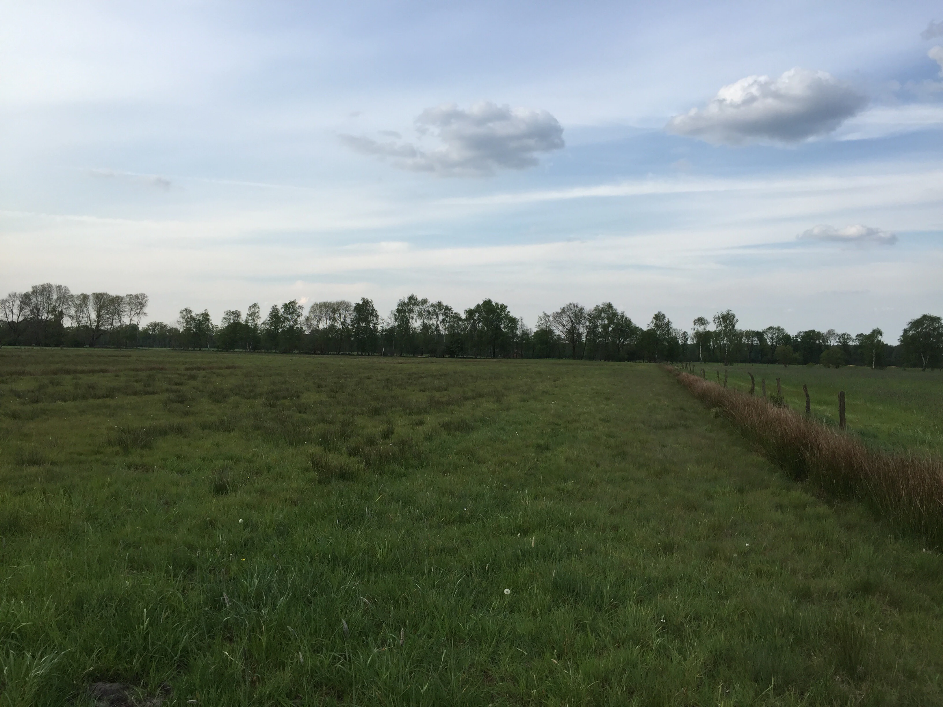
A wide, flat green meadow in Suddenmoor stretching to a distant treeline under a cloudy blue sky.
Open meadows and hedgerows characteristic of the landscape in Suddenmoor.

Suddenmoor history and protected-area timeline

The current Suddenmoor Nature Reserve was formally designated on 1 July 2018 by the district of Osnabrück, the responsible lower nature protection authority. The designation of roughly 311 hectares under the identifier NSG WE 303 gave the area its own independent protected status.

Prior to this, Suddenmoor had been protected jointly with the neighboring Anten reserve as the combined protected area "Suddenmoor/Anten". The splitting of this earlier designation into two separate reserves reflects a more refined approach to conserving the distinct wetland, meadow, and hedge-dominated habitats of each area.

The cultural landscape in which the reserve sits is much older. The Wallhecken that frame the fields, the network of drainage ditches connecting the area to the Renslager Canal and onward to the Hahnenmoorkanal, and the long-established agricultural use of the peat soils all belong to a centuries-old pattern of land management in the Artland. The formal nature reserve status of 2018 was therefore less about creating a new habitat than about safeguarding, in a more structured way, a traditional cultural landscape whose ecological value had become increasingly important as farmland bird populations declined across Germany.

Suddenmoor landscape and geographic character

Suddenmoor lies on a very gently undulating, almost flat stretch of land, rising only from about 22 to 25 meters above sea level. The terrain reflects its origin as lowland peatland, now drained and shaped into a finely divided agricultural landscape. The ground is dominated by wet peat soils, locally enriched by mineral substrates, with a mosaic of meadows, small woodland patches, and shrubby field boundaries.

The defining visual elements of the reserve are the wide open meadow horizons broken up by Wallhecken, the traditional hedge-banked field boundaries that give the western Artland its distinctive rhythm. Tree lines and small field copses add structure, particularly along the northwestern and southern edges, while the northeastern portion of the reserve remains largely open and treeless.

A dense network of drainage ditches crosses the area, carrying water northward toward the Renslager Canal and eventually into the Hahnenmoorkanal. These ditches are not just hydrological features but an integral part of the landscape, creating structural variety in otherwise uniform grasslands and connecting the small bog woodland fragments to the wider peatland system of the region.

Suddenmoor ecosystems, habitats, and plant life

The ecological identity of Suddenmoor centers on wet grassland habitats developed over peat soils. The most recognized communities are flower-rich lowland meadows, of which approximately 20 hectares are classified as the EU priority habitat "lowland hay meadows" and qualify as valuable for conservation under the Habitats Directive. These meadows are moderately species-rich, with a core matrix of common agricultural grasses and a more diverse herb layer on the poorest soils.

Where grazing or mowing has stopped, the vegetation has shifted into wet grassland and tall herb communities, with small patches of true swamp developing in the wettest corners. Equally important are the bog woodland and alder carr remnants scattered through the meadows, supporting sphagnum mosses, cottongrass, brown sedge, marsh pennywort, and bog lily. On the driest peat, tiny fragments of moor heath persist, with bell heather, cottongrass, purple moor grass, and sphagnum.

The combination of peatland, open wet meadow, hedge, and scrub creates a habitat pattern that is increasingly rare in the intensively farmed northwest German plain, and that is closely linked ecologically to the nearby Hahlener Moor and Anten reserves.

Suddenmoor wildlife and species highlights

The reserve is, above all, a bird-protected landscape. Its open northeastern meadows are crucial breeding habitat for ground-nesting waders such as curlew and lapwing, while meadow pipit, whinchat, and stonechat use the same open grassland along with their associated hedge networks. The Wallhecken, tree lines, and field copses add woody-edge species, so that the reserve effectively supports open-country, hedge, and woodland bird communities within a single compact area.

The wetland character of the site makes it equally important for amphibians and reptiles, which use the ditches, wet grassland, and bog fragments as breeding and shelter habitat. The water-filled ditches and bog-influenced pools are also valuable for dragonflies, while the mix of grassland types supports a diverse grasshopper fauna. Together these groups make Suddenmoor a small but species-rich refuge for the typical fauna of northwestern German peatland and wet meadow habitats.

Suddenmoor conservation status and protection priorities

Suddenmoor was placed under formal nature protection on 1 July 2018 to preserve a representative example of culturally shaped peatland that still holds significant lowland meadow, bog, and farmland wildlife habitat. The reserve's designation under the code NSG WE 303 gave it long-term legal protection under Lower Saxon nature conservation law, with the district of Osnabrück as the responsible authority.

The conservation significance of the reserve extends beyond its own boundaries. Most of its area forms part of the EU Habitats Directive site "Hahnenmoor, Hahlener Moor, Suddenmoor," which was established to protect habitat types and species of European importance. Inclusion in this network reflects the international recognition of the reserve's lowland hay meadows, bog woodland remnants, and moor heath fragments.

The southern edge of the reserve connects to the protected landscape of the Naturpark Nördlicher Teutoburger Wald, Wiehengebirge, and to the north lies the larger Hahlener Moor. Suddenmoor therefore functions as a key inner component of a larger regional network that links protected peatland reserves in the Artland with the upland landscapes of the Teutoburg Forest and Wiehengebirge.

Suddenmoor cultural meaning and human context

Suddenmoor is a protected component of the Artland cultural landscape, one of the most distinctive traditional farming regions of northwestern Germany. The Wallhecken, the small fields, the hedges, tree rows, and the centuries-old pattern of ditches and meadows are as much expressions of local land use as they are ecological structures, and they define the visual identity of the reserve today.

The reserve was originally part of the larger joint designation "Suddenmoor/Anten," reflecting how closely knit the local land-use and ecological heritage of this part of the district of Osnabrück has historically been. The decision to split that combined designation and protect Suddenmoor as its own reserve in 2018 underscores how strongly the local population and authorities value this traditional landscape in its own right.

Top sights and standout views in Suddenmoor

Suddenmoor's strongest qualities lie in the combination of extensive open wet meadows, Wallhecken-shaped field mosaics, and bog woodland remnants that together create a rare continuous habitat for lowland farmland wildlife. Its curlew, lapwing, and meadow-breeding songbird populations, along with the EU-recognized lowland hay meadows and bog fragments, mark it out as an unusually intact piece of the Artland countryside.

The reserve is also notable for being part of a much wider protected-area network that links the Hahlener Moor, Anten, the Naturpark Nördlicher Teutoburger Wald, Wiehengebirge, and the TERRA.vita Nature and Geopark, giving Suddenmoor a role as a small but meaningful node in the regional conservation strategy of northwestern Germany.

Best time to visit Suddenmoor

The most rewarding seasons for visiting Suddenmoor are late spring and early summer, when the meadows are at their most species-rich and breeding waders and open-country songbirds are most active and vocal. In this period, the open character of the reserve, the flowering hay meadows, and the visible diversity of the Wallhecken are at their strongest.

Late summer and early autumn can also be interesting, as the agricultural use of neighbouring fields changes and the wetter parts of the reserve remain visually distinct from the surrounding farmland. Conditions are generally mild, given the very low elevation of the area.


Monthly climate preview

Long-term temperature and precipitation records across twelve months at Suddenmoor

Suddenmoor Climate Normals and Measured Annual Weather by Month

Representative coordinate records outline the annual temperature range and monthly precipitation rhythm measured at Suddenmoor between 1991 and 2020. Detailed multi-year climate normals provide complete month-by-month averages for temperature extremes and precipitation totals.
Annual mean10 °C
1 °C18 °C
Jan
Feb
Mar
Apr
May13°
Jun16°
Jul18°
Aug18°
Sep14°
Oct10°
Nov
Dec
Warmest month
July

18.2 °C

Coolest month
January

1.4 °C

Wettest month
December

2.4 mm/day

Driest month
April

1.4 mm/day

Park location guide

Geography guide, regional context, and park location map for Suddenmoor

Suddenmoor park geography, regions, and map view in Germany

Understand where Suddenmoor sits in Germany through a broader geographic reading of the surrounding landscape, nearby location context, and its mapped position within the national park landscape.

How Suddenmoor fits into Germany

Germany is a federal republic in Western and Central Europe with a population of over 83 million across sixteen constituent states. It is Europe's largest economy by nominal GDP and a major global exporter and importer. The capital is Berlin, and the country borders Denmark, Poland, Czech Republic, Austria, Switzerland, France, Luxembourg, Belgium, and the Netherlands.

Wider geography shaping Suddenmoor in Germany

Germany is located in Western and Central Europe, spanning 357,022 km². It borders Denmark to the north, Poland and the Czech Republic to the east, Austria and Switzerland to the south, and France, Luxembourg, Belgium, and the Netherlands to the west. The country has coastlines on the Baltic Sea and North Sea to the north, with the Alps located in the southern region.

Map view of Suddenmoor

Use this park location map to pinpoint Suddenmoor in Germany, understand its exact geographic position, and read its mapped placement within the surrounding landscape more clearly.

Pigeon | © OpenStreetMap contributors

Location context for Suddenmoor

Landkreis OsnabrückLower Saxony

Protected area views of wet meadows, peat soils, and hedgerow habitats in Lower Saxony

Suddenmoor Photos and Landscape Scenery Visual Exploration

Visual records capture the open lowland landscapes, wet peat pastures, and traditional hedge boundaries that define the protected terrain of Suddenmoor. Examining these habitat views helps researchers and naturalists understand the ecological structure of the western Artland wetland mosaic.

A wide, flat green meadow in Suddenmoor stretching to a distant treeline under a cloudy blue sky.

Park atlas

Discover related wetland reserves and regional conservation areas across Lower Saxony.

Explore Parks Near Suddenmoor and Surrounding Protected Landscapes

Compare Suddenmoor with nearby national parks and protected areas across the surrounding lowland region to understand shared wetland habitats. Examining adjacent reserves reveals the broader ecological network connecting regional peatlands and agricultural mosaics.
Nature reserveEmsland
About 10 km away#1 closest

Northwest

Zitterteiche Nature Reserve in Emsland: Mapped Protected Landscapes and Geography

A study of lowland heath ponds and environmental history

Zitterteiche represents a specific, small-scale nature reserve in the Emsland of Germany, consisting of two shallow heath ponds defined by their surrounding agricultural plains. This detailed entry maps the physical terrain and ecological shift of these protected waters, offering a focused perspective on the regional geography and the historical trajectory of this unique, formally protected wetland area.

Area
0.029 km²
Established
1937
IUCN
IV
Relief
Lowland
Nature reserveLandkreis Osnabrück
About 14 km away#2 closest

Southwest

Swatte Poele: Protected Heath Ponds and Glacial Moraine Geography in Landkreis Osnabrück

A mapped nature reserve and FFH habitat area.

The Swatte Poele nature reserve protects a distinctive glacial complex where shallow heath ponds meet wet mires and dry sandy heaths. Located within the Fensterberge end moraine, the site functions as an important ecological node in the broader European habitat network. This detailed map and landscape overview examines the terrain transitions and conservation status of this small yet biologically dense German protected area.

Area
0.043 km²
Established
1976
Nature reserveLower Saxony
About 21 km away#3 closest

Northwest

Südtannenmoor Nature Reserve in Lower Saxony: An Atlas of Protected Bog Wetlands

Mapping rare heath pool ecosystems in the Emsland region

This nature reserve protects a fragile intersection of raised-bog remnants and shallow heath pools framed by coniferous forests. The site serves as a key reference for the restoration of specialized wetland vegetation in northwestern Germany, offering a clear view of how small-scale geography influences biodiversity in the Emsland landscape.

Area
0.049 km²
Established
2009
IUCN
IV
Relief
Lowland
Protected landscapeEmsland
About 23 km away#4 closest

Northwest

Naturpark Hümmling: Geographic Overview of Emsland Protected Landscapes

Tracing glacial sand ridges, moorlands, and prehistoric cultural sites.

Naturpark Hümmling stands as a prominent protected landscape in Lower Saxony, characterized by its distinctive geest ridge, extensive raised bogs, and dense concentration of Neolithic stone monuments. The area map highlights a complex interplay of river valleys, heathland remnants, and historic cultural landmarks that define the geographical identity of this Emsland treasure.

Area
576 km²
Established
2015
Relief
Upland
Climate
Temperate
A soft watercolor painting of a rolling landscape with green fields, scattered evergreen and deciduous trees, and distant hills under a light sky.
Nature reserveNorth Rhine-Westphalia
About 25 km away#5 closest

South

Koffituten Nature Reserve and the Protected Bog Landscapes of North Rhine-Westphalia

A study of raised bog regeneration and inland dune ecosystems.

Koffituten provides a clear look at bog restoration and land management within the Steinfurt district. This nature reserve protects a rare raised bog island alongside a mix of pine-oak forest, fen woodland, and inland dunes. Its compact size and historical restoration work make it a focal point for understanding the interplay between wetland and dry-land habitats in the German lowlands.

Area
0.236 km²
Established
1991
Relief
Lowland
Climate
Temperate
Nature reserveLandkreis Cloppenburg
About 32 km away#6 closest

Northeast

Talsperre Thülsfeld Nature Reserve: Geography and Protected Land Profile

Inland dune and wetland conservation in Landkreis Cloppenburg

Talsperre Thülsfeld functions as a protected nature reserve showcasing the traditional northwest German lowland landscape. The site contains a five kilometer long reservoir, expansive heathlands, and bog communities, offering a clear view of how glacial geography shapes modern conservation areas. Researchers and observers can examine the transition between dry sandy dunes and damp riverine floodplains within this concentrated ecological boundary.

Area
4.62 km²
Established
1957
Relief
Lowland
Climate
Temperate
Nature reserveLower Saxony
About 33 km away#7 closest

Northwest

Windelberg Nature Reserve: Protected Inland Dune and Heathland Mosaic in Lower Saxony

Historic sandy heath and oak woodland conservation site

Windelberg is a significant nature reserve in the Emsland region, featuring inland dunes and juniper heathland on the Hümmling glacial ridge. This area showcases a compact mosaic of dry, acidic habitats and relict oak woodland that reflects centuries of traditional land management in northwest Germany. Its status as a protected area within the Natura 2000 network highlights its importance for regional habitat conservation.

Area
0.163 km²
Established
2009
IUCN
IV
Nature reserveLandkreis Emsland
About 38 km away#8 closest

Northwest

Stillgewässer bei Kluse Nature Reserve: Geographic Overview and Protected Wetland Landscape

Mapping the distinctive aquatic corridors of Landkreis Emsland.

Stillgewässer bei Kluse features a compact yet diverse mosaic of standing water pools, floating bog fringes, and oak woodlands on sandy soils. As a protected nature reserve, it functions as a crucial ecological refuge within the Emsland agricultural landscape, offering a unique opportunity to study man-made wetlands that have evolved into mature natural habitats.

Area
0.521 km²
Established
2018
Relief
Lowland
Climate
Temperate

Common questions about visiting, size, designation, and location context for Suddenmoor

Suddenmoor FAQs for park facts, access, geography, and protected area context

Find quick answers about Suddenmoor, including protected-area facts, park geography, trail and visitor context, and how the park fits into its surrounding country and regional landscape.
MoriAtlas Explorer

Continue Your Protected Areas Search Across the Global Atlas

Deepen your exploration by continuing the structured search for national parks and protected areas worldwide. Utilize the comprehensive filtering capabilities to compare different conservation landscapes and refine your understanding of global park geography. Discover more about the distribution and characteristics of protected natural areas.

Global natural geography