Mori Atlas logo
Nature reserveSüdlicher Bliesgau/Auf der Lohe

Mapping the calcareous slopes, orchid-rich meadows, and ridge terrain of the southern Bliesgau region

Südlicher Bliesgau/Auf der Lohe: A Protected Nature Reserve in the Saarland Cultural Landscape

(Naturschutzgebiet Südlicher Bliesgau/Auf der Lohe)

Südlicher Bliesgau/Auf der Lohe encompasses varied hillside terrain and ridge systems west of the Blies river valley in Saarland. This nature reserve, characterized by its Muschelkalk limestone soils, preserves a mosaic of semi-open slopes that host sensitive orchid-rich meadow habitats. Its geography forms a vital link within a broader cluster of protected landscapes along the German-French border region.

nature reserveNaturschutzgebietorchid meadowscalcareous slopesBliesgauSaarland

Südlicher Bliesgau/Auf der Lohe

Nature reserve

Park overview

Structured park overview, official facts, and landscape profile for Südlicher Bliesgau/Auf der Lohe

Südlicher Bliesgau/Auf der Lohe park facts, protected area profile, and essential visitor context

Review the core facts for Südlicher Bliesgau/Auf der Lohe, including designation, size, terrain, visitor scale, habitats, and operating context in one park-focused overview.

About Südlicher Bliesgau/Auf der Lohe

Südlicher Bliesgau/Auf der Lohe is a substantial nature reserve situated in the southern portion of the Bliesgau, a culturally and ecologically distinctive region in the eastern Saarland near the French frontier. Covering roughly 15.75 square kilometres, the reserve extends across the municipal territories of Blieskastel and Mandelbachtal, encompassing a network of hillsides, ridgelines, and valley-edge terrain west of the Blies river.

The landscape of the protected area is shaped by gentle to moderately steep slopes, often underlain by calcareous substrates that have given the broader region its reputation for species-rich semi-natural grassland. This combination of geology, slope exposure, and long-standing land use traditions supports the orchid-rich meadows for which the reserve is particularly noted. Walking routes, such as the Orchideenpfad referenced in regional visitor information, allow close-up encounters with these habitats.

In the broader conservation framework of Saarland, the reserve plays a connecting role between neighbouring protected sites. To the west lie the Muschelkalkhänge bei Bebelsheim und Wittersheim, a 197-hectare reserve focused on calcareous slope habitats, while to the east across the Blies river extends the Zwischen Bliesdalheim und Herbitzheim reserve (124 hectares). Together with these sites, Südlicher Bliesgau/Auf der Lohe contributes to a contiguous belt of protected ecological corridors linking calcareous slopes, dry grasslands, and floodplain environments along this border stretch of the Saar.

The reserve is administered by the Saarpfalz-Kreis and recognized internationally through inclusion in the World Database on Protected Areas (WDPA ID 329663). Its IUCN Category IV designation indicates that management focuses on maintaining or restoring particular species and habitat types, aligning the site with conservation aims rather than large-scale wilderness protection.

Quick facts and research context for Südlicher Bliesgau/Auf der Lohe

Südlicher Bliesgau/Auf der Lohe is a nature reserve of about 15.75 square kilometres in the Saarpfalz-Kreis district of Saarland, located in the southern part of the Bliesgau cultural landscape near the French border. Classified as an IUCN Category IV Habitat/Species Management Area, it was established by decree on 26 March 2004 with the identifier NSG-108. The reserve lies west of the Blies river, between Ballweiler and Habkirchen, and forms part of a network of neighbouring protected sites including adjacent calcareous slope areas and Blies floodplain reserves.

Protection and recognition

Examine official records and international recognition data for this protected landscape

Südlicher Bliesgau/Auf der Lohe Protection Status and Protected Area Designation Facts

Südlicher Bliesgau/Auf der Lohe holds documented protection status details stored within official databases. Protected area records outline the established designation framework and international recognition context.

Protection details

WDPA ID
329663
Park context

Deeper park guide and search-rich context for Südlicher Bliesgau/Auf der Lohe

Südlicher Bliesgau/Auf der Lohe history, landscape, wildlife, and travel context

Explore Südlicher Bliesgau/Auf der Lohe through its history, landscape character, ecosystems, wildlife, conservation priorities, cultural context, and seasonal travel timing in a structured park guide built for atlas discovery and search intent.

Why Südlicher Bliesgau/Auf der Lohe stands out

The reserve is best known for its hillside orchid meadows (Orchideenwiesen), semi-open calcareous slope habitats, and its role within a cluster of ecologically linked protected areas along the German-French section of the Blies valley. These slopes, rich in lime-influenced soils and traditional land use, support habitat conditions favoured by specialist plant communities.
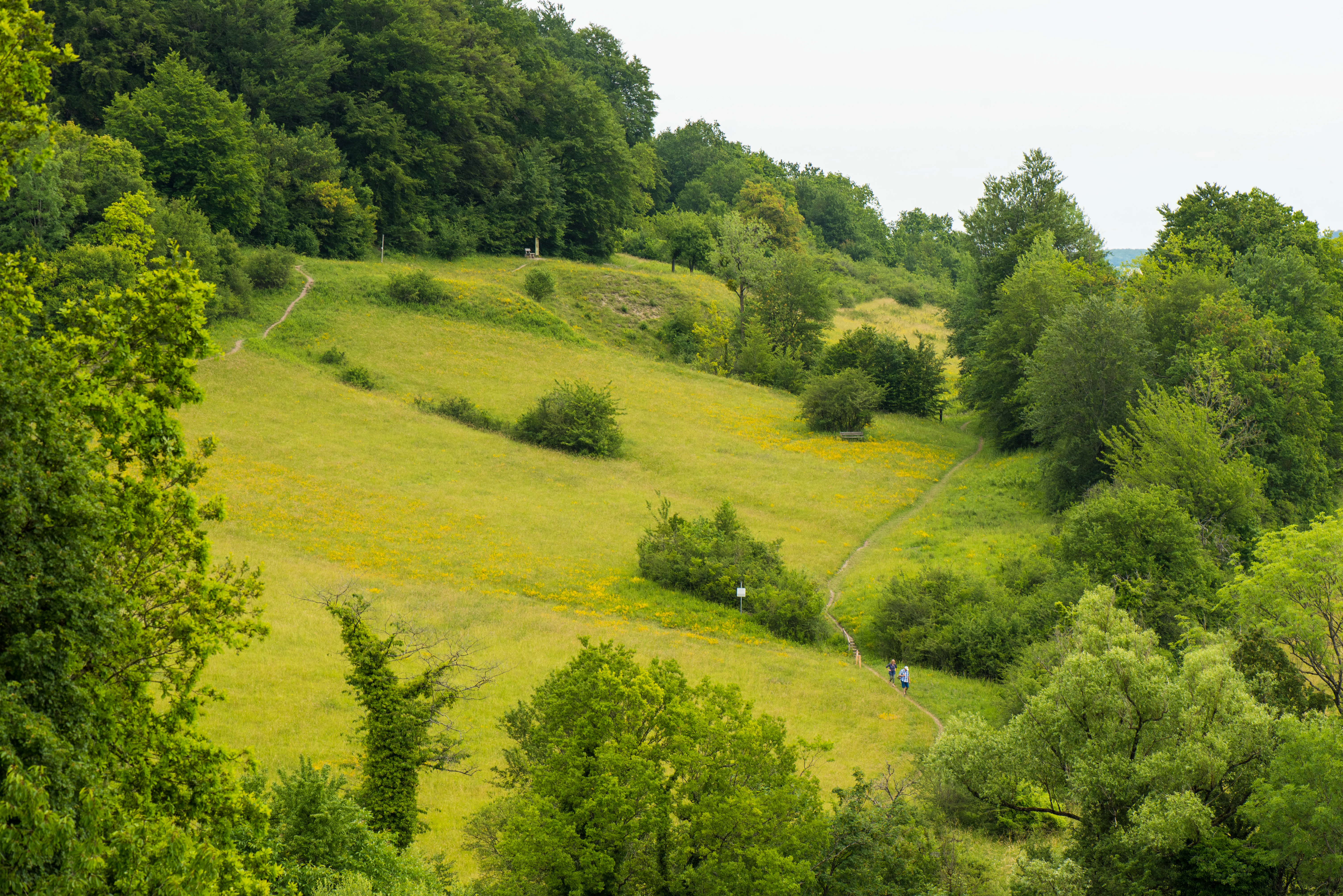
A wide-angle view of a green grassy hillside featuring a narrow hiking trail cutting through the meadow, bordered by dense deciduous forests and small shrubs.
A hiking trail winding through the grassy slopes of the Orchideenpfad in Gersheim.

Südlicher Bliesgau/Auf der Lohe history and protected-area timeline

The area gained formal nature conservation recognition through a decree issued on 26 March 2004, designated as NSG-108, establishing Südlicher Bliesgau/Auf der Lohe as a protected Naturschutzgebiet under Saarland's nature conservation law. The designation was recorded with an official effective date of 25 March 2004.

The reserve emerged as part of a broader regional effort to safeguard the calcareous slope habitats and species-rich meadows of the southern Bliesgau, an area historically shaped by traditional agricultural land use. Its establishment contributed to a network of complementary protected sites along the Blies valley and the German-French border region, reinforcing landscape-scale habitat connectivity. Beyond the formal designation, the available documentation does not provide deeper historical narrative.

Südlicher Bliesgau/Auf der Lohe landscape and geographic character

The reserve occupies west-facing and varied hillside terrain west of the Blies river valley, with elevation differences and slope exposures that create diverse microhabitats. Soils derived from calcareous parent material, particularly Muschelkalk (shell limestone) substrates, underpin much of the area and contribute to the distinctive botanical character of the slopes.

The B 423 federal road runs along the western edge and through the southern portion of the area, while the L 105 state road crosses the eastern and southern sections. The Blies river itself flows around the reserve to the east, south, and southwest, defining the broader hydrological setting. Along the southeastern edge, the international border with France marks the boundary of the protected landscape.

The terrain transitions between forested ridges, open meadow slopes, and valley-edge habitats, producing a structurally varied protected area that supports the semi-open cultural landscape mosaic typical of the southern Bliesgau.

Südlicher Bliesgau/Auf der Lohe ecosystems, habitats, and plant life

Ecologically, Südlicher Bliesgau/Auf der Lohe is associated with calcareous grassland communities, semi-open hillside meadows, and ridge-and-slope woodlands on limestone-derived substrates. These habitats support the orchid-rich meadows that are central to the reserve's identity and conservation profile.

The combination of slope orientation, soil chemistry, and traditional land use has created conditions favourable to specialized plant communities. The reserve functions as part of a mosaic in which calcareous slopes transition to more acidic or mesic habitats, reinforcing habitat diversity within a relatively compact area. The landscape pattern echoes the broader ecological character of the Bliesgau, recognized at regional and cross-border scales for habitat-rich cultural landscapes.

Südlicher Bliesgau/Auf der Lohe conservation status and protection priorities

As an IUCN Category IV Habitat/Species Management Area, the reserve's primary conservation objective centers on the maintenance and management of specific habitat types, particularly calcareous slope grasslands and the orchid meadow communities they support. The designation emphasizes active habitat stewardship over strict preservation, allowing management interventions that sustain the semi-open landscape character.

Within the Saarpfalz-Kreis network of Naturschutzgebiete, the reserve functions as a key node connecting the Muschelkalkhänge bei Bebelsheim und Wittersheim to the west with the Bliesaue habitats of Zwischen Bliesdalheim und Herbitzheim to the east. This positioning supports ecological connectivity across slope, river, and floodplain habitats along a sensitive border region, enhancing the overall conservation value of the site within Saarland's protected-area system.

Südlicher Bliesgau/Auf der Lohe cultural meaning and human context

The reserve lies in a region where long-standing agricultural and pastoral land use has shaped the cultural landscape, particularly through traditional meadow management that maintains the open habitats on which species-rich grasslands depend. The southern Bliesgau itself carries strong regional identity in Saarland, marked by its half-timbered village architecture, cross-border traditions, and historical interactions with neighbouring Lorraine in France.

The presence of educational and recreational trails, such as the Orchideenpfad at Gersheim, reflects the integration of nature conservation with local cultural landscape appreciation and regional nature tourism.

Top sights and standout views in Südlicher Bliesgau/Auf der Lohe

Among the reserve's most distinctive features are its orchid-rich meadows, known locally as Orchideenwiesen, which have become a recognized symbol of the site's conservation value. The calcareous slopes derived from Muschelkalk substrates define both the scenery and ecological character of the area.

The reserve's position within a cluster of protected areas along the Blies valley also stands out as a defining strength, linking slope habitats with floodplain reserves and cross-border ecological gradients near France. Its accessibility through local hiking trails adds a practical dimension to its conservation and educational role.

Best time to visit Südlicher Bliesgau/Auf der Lohe

The late spring to early summer period is typically when the orchid-rich meadows of the Bliesgau slopes are most expressive, with flowering peaks influencing both the visibility of the reserve's characteristic habitats and the appeal of walking routes such as the Orchideenpfad. Warmer months also make ridge and slope trails more comfortable for exploring the wider landscape mosaic of hills, meadows, and Blies valley edges.

In higher seasons, the cultural landscape itself, including surrounding villages and viewpoints across the protected slopes, becomes part of the broader visit experience. Cooler months offer quieter conditions and a different reading of the terrain, with structural landscape features becoming more apparent once the meadows recede.

Monthly climate preview

Long-term representative coordinate measurements of monthly temperature and precipitation patterns

Annual Climate Normals and Temperature Rhythms for Südlicher Bliesgau/Auf der Lohe

Historical data recorded between 1991 and 2000 reveals a measured annual sequence of average temperatures and daily precipitation rates across the representative coordinate. Reviewing the comprehensive monthly breakdown provides deeper insight into the local climate normals and long-term meteorological baseline.
Annual mean10 °C
0 °C19 °C
Jan
Feb
Mar
Apr
May13°
Jun17°
Jul19°
Aug19°
Sep15°
Oct10°
Nov
Dec
Warmest month
July

19.5 °C

Coolest month
January

0.5 °C

Wettest month
December

2.6 mm/day

Driest month
April

1.6 mm/day

Park location guide

Geography guide, regional context, and park location map for Südlicher Bliesgau/Auf der Lohe

Südlicher Bliesgau/Auf der Lohe park geography, regions, and map view in Germany

Understand where Südlicher Bliesgau/Auf der Lohe sits in Germany through a broader geographic reading of the surrounding landscape, nearby location context, and its mapped position within the national park landscape.

How Südlicher Bliesgau/Auf der Lohe fits into Germany

Germany is a federal republic in Western and Central Europe with a population of over 83 million across sixteen constituent states. It is Europe's largest economy by nominal GDP and a major global exporter and importer. The capital is Berlin, and the country borders Denmark, Poland, Czech Republic, Austria, Switzerland, France, Luxembourg, Belgium, and the Netherlands.

Wider geography shaping Südlicher Bliesgau/Auf der Lohe in Germany

Germany is located in Western and Central Europe, spanning 357,022 km². It borders Denmark to the north, Poland and the Czech Republic to the east, Austria and Switzerland to the south, and France, Luxembourg, Belgium, and the Netherlands to the west. The country has coastlines on the Baltic Sea and North Sea to the north, with the Alps located in the southern region.

Map view of Südlicher Bliesgau/Auf der Lohe

Use this park location map to pinpoint Südlicher Bliesgau/Auf der Lohe in Germany, understand its exact geographic position, and read its mapped placement within the surrounding landscape more clearly.

Pigeon | © OpenStreetMap contributors

Location context for Südlicher Bliesgau/Auf der Lohe

Saarland

Visual exploration of calcareous slopes, meadow habitats, and protected terrain.

Südlicher Bliesgau/Auf der Lohe Photos and Landscape Scenery

Visual records capture the distinctive ridge and slope topography, calcareous meadows, and semi-open habitats of Südlicher Bliesgau/Auf der Lohe. Photographic documentation reveals the underlying limestone terrain, rare plant communities, and protected landscape character across the region.

A wide-angle view of a green grassy hillside featuring a narrow hiking trail cutting through the meadow, bordered by dense deciduous forests and small shrubs.

Park atlas

Compare adjacent limestone slopes, river valley reserves, and regional conservation areas

Explore Other Parks Near Südlicher Bliesgau/Auf der Lohe and Surrounding Protected Landscapes

Browse protected areas situated around Südlicher Bliesgau/Auf der Lohe to examine connected calcareous habitats and valley-edge ecosystems. Extending your geographic comparison reveals broader regional terrain patterns and related conservation landscapes across the border.
A soft watercolor illustration depicting a river flowing through a lush green floodplain with trees, grasses, and a hazy background.
Nature reserveSaarland
About 5.6 km away#1 closest

Northeast

Bliesaue zwischen Blieskastel und Bliesdalheim Nature Reserve and Regional Landscape Geography

Protected floodplain ecosystems in Saarland, Germany

The Bliesaue zwischen Blieskastel und Bliesdalheim protects a near-natural river course and its surrounding floodplain in the Saarland region. The reserve is characterized by complex soil conditions from Buntsandstein and Muschelkalk substrates, supporting a rich network of wetlands, marshes, and meadows that function as a cohesive ecological unit for migratory birds and protected species.

Area
1.981 km²
Established
2015
Relief
Lowland
Climate
Temperate
A soft watercolor illustration depicting a panoramic landscape with rolling green hills, distant pink-hued mountains, and a rocky outcrop in the foreground.
Nature reserveSaarland
About 7 km away#2 closest

Northwest

Birzberg, Honigsack/Kappelberghang bei Fechingen: Saarland Protected Nature Reserve Geography

Mapping the slope woodlands and riparian habitats near Saarbrücken

Spanning 188 hectares across the Saar valley margins, this nature reserve is defined by its varied hillside topography and calcareous soil influence. The protected area supports a complex mosaic of woodland slopes and grassland environments, providing a crucial habitat corridor within the Saarland region of Germany.

Area
1.88 km²
Established
2016
Nature reserveSaarland
About 9.8 km away#3 closest

Northwest

Wusterhang und Beierwies bei Fechingen: Protected Nature Reserve and Habitat Map

A study of calcareous beech forests and meadow geography in Saarland

Wusterhang und Beierwies bei Fechingen is a specialized nature reserve that captures the essential habitat diversity of the Saarland region. The area is defined by its small-scale mosaic of woodruff beech forest, orchid-rich calcareous slopes, and nutrient-poor grasslands. By examining this protected site, you can better understand the intersection of forest and meadow ecosystems that define this specific part of southwestern German geography.

Nature reserveSaarland
About 11 km away#4 closest

Northeast

Badstube Mimbach Nature Reserve: Protected Limestone Grasslands and Woodland in Saarland

A regional atlas exploration of Saarland biodiversity hotspots

Badstube Mimbach stands as a significant nature reserve located within the Bliesgau region of Saarland. This protected landscape is defined by its south-facing limestone slopes and terraced fields, providing essential habitat for rare flora and specialized fauna in a compact ten-hectare mosaic of open meadow and beech forest.

Area
0.095 km²
Established
2016
IUCN
IV
Nature reserveGermany
About 17 km away#5 closest

North

Taubental Nature Reserve: Protected Landscape and Forest Geography in Germany

Core zone forest conservation in the Saarpfalz district.

Taubental Nature Reserve protects a continuous stretch of mixed broadleaf and coniferous forest situated on the Buntsandstone ridges of southwestern Germany. As a core zone within the Bliesgau Biosphere, it maintains essential habitat connectivity despite its proximity to major regional infrastructure, providing a unique case study in forest preservation within the Saarpfalz-Kreis landscape.

Area
4.26 km²
Established
2007
Nature reserveRheinland-Pfalz
About 17 km away#6 closest

East

Monbijou Nature Reserve: Mapped Protected Landscapes in the Südwestpfalz District

Regional geography and conservation of dry grassland habitats

Monbijou stands as a significant twenty-six hectare nature reserve in Rheinland-Pfalz, defined by its mosaic of sun-exposed dry grasslands and forest-edge communities. This protected area plays a crucial role in maintaining rare plant species and uncommon animal habitats within the rolling terrain of the southwestern Palatinate, near the Hornbach stream and the local airfield.

Area
0.26 km²
Established
1978
Scope
Terrestrial
Water
Minor water
A soft, artistic watercolor painting showing a wide, tranquil wetland scene with soft green and yellow hues, distant rolling hills, and patches of trees and vegetation in a floodplain environment.
Protected landscapeSaarland
About 20 km away#7 closest

Northeast

Beeder Bruch Protected Landscape: Blies River Floodplain and Wetland Geography in Saarland

A managed riverine sanctuary in the Bliesgau Biosphere Reserve

Beeder Bruch is a formally recognized protected landscape in Saarland, defined by the extensive floodplain of the Blies river. The site integrates wet meadows, riparian forests, and reedbeds, serving as a key European bird protection zone. Visitors can explore the mapped terrain, which utilizes conservation grazing to maintain essential wetland habitats and support local biodiversity within the Bliesgau region.

Area
127 km²
Established
2015
IUCN
V
Nature reserveRheinland-Pfalz
About 21 km away#8 closest

East

Wahlbacher Heide Nature Reserve: Geographic Mapping and Protected Landscape Analysis

Explore the Muschelkalk dry grasslands of the Westpfalz region

Wahlbacher Heide offers a focused look at the calcareous dry grassland habitats within the Westpfalz region of Germany. This nature reserve provides essential insights into the preservation of rare orchids and gentians on Lower Muschelkalk bedrock. Use this mapped resource to understand the interplay between the crescent-shaped open meadows, juniper stands, and the surrounding agricultural corridor that frames this important protected site.

Area
0.074 km²
Established
1985

Common questions about visiting, size, designation, and location context for Südlicher Bliesgau/Auf der Lohe

Südlicher Bliesgau/Auf der Lohe FAQs for park facts, access, geography, and protected area context

Find quick answers about Südlicher Bliesgau/Auf der Lohe, including protected-area facts, park geography, trail and visitor context, and how the park fits into its surrounding country and regional landscape.
MoriAtlas Explorer

Continue Your Protected Areas Search Across the Global Atlas

Deepen your exploration by continuing the structured search for national parks and protected areas worldwide. Utilize the comprehensive filtering capabilities to compare different conservation landscapes and refine your understanding of global park geography. Discover more about the distribution and characteristics of protected natural areas.

Global natural geography