
Mori Atlas logo
National parkTai Rom Yen National Park

Discover the mapped boundaries and protected landscape context of Tai Rom Yen National Park.

Tai Rom Yen National Park: A National Park Detail Page for Thailand's Geography

Tai Rom Yen National Park represents a key protected natural area within Thailand's diverse geography. As a designated national park, it offers critical landscape context for understanding regional conservation and mapped natural territories. This page serves as a gateway to exploring the park's specific geographic features and its role within the broader atlas of Thailand's protected lands, focusing on its boundaries and environmental significance without travel-specific details.

ThailandNational ParkSoutheast AsiaProtected Area

Tai Rom Yen National Park

National park

Park overview

Structured park overview, official facts, and landscape profile for Tai Rom Yen National Park

Tai Rom Yen National Park park facts, protected area profile, and essential visitor context

Review the core facts for Tai Rom Yen National Park, including designation, size, terrain, visitor scale, habitats, and operating context in one park-focused overview.
Monthly climate preview

Long-term representative point measurements tracking monthly temperature and precipitation rhythm

Tai Rom Yen National Park Climate Normals and Annual Weather by Month

Recorded baseline data captures the multiyear average temperature and precipitation rhythm across twelve measured monthly intervals at Tai Rom Yen National Park. Reviewing the complete monthly profile provides detailed context on long-term climate normals without relying on live forecasts.
Annual mean26 °C
25 °C28 °C
Jan25°
Feb26°
Mar27°
Apr28°
May28°
Jun27°
Jul26°
Aug26°
Sep26°
Oct26°
Nov26°
Dec25°
Warmest month
April

28.2 °C

Coolest month
January

25.2 °C

Wettest month
November

10.7 mm/day

Driest month
February

1.3 mm/day

Park location guide

Geography guide, regional context, and park location map for Tai Rom Yen National Park

Tai Rom Yen National Park park geography, regions, and map view in Thailand

Understand where Tai Rom Yen National Park sits in Thailand through a broader geographic reading of the surrounding landscape, nearby location context, and its mapped position within the national park landscape.

How Tai Rom Yen National Park fits into Thailand

Thailand is a Southeast Asian nation formerly called Siam, located in mainland Southeast Asia. It operates as a unitary parliamentary constitutional monarchy under King Vajiralongkorn. The country borders Myanmar, Laos, Cambodia, and Malaysia, with maritime boundaries involving Vietnam, Indonesia, and India. Thailand has a population of nearly 66 million and covers approximately 513,120 km². Historically, the Sukhothai Kingdom marks the beginning of Thai history, followed by the powerful Ayutthaya Kingdom.

Wider geography shaping Tai Rom Yen National Park in Thailand

Thailand occupies mainland Southeast Asia with borders to Myanmar (west/northwest), Laos (east/northeast), Cambodia (southeast), and Malaysia (south). The country has coastline along the Gulf of Thailand to the southeast and the Andaman Sea to the southwest. The territory covers approximately 513,120 km².

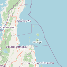
Map view of Tai Rom Yen National Park

Use this park location map to pinpoint Tai Rom Yen National Park in Thailand, understand its exact geographic position, and read its mapped placement within the surrounding landscape more clearly.

Pigeon | © OpenStreetMap contributors
Park atlas

Map the Surrounding Protected Landscapes and Compare National Park Geography in Thailand

Continue Park Discovery: Explore National Parks and Protected Areas Near Tai Rom Yen National Park

After exploring Tai Rom Yen National Park, trace the connected network of national parks and other protected areas across the surrounding region, focusing on their unique geographic contexts and conservation profiles. This enables deeper atlas-style park discovery, allowing users to compare diverse landscapes and understand regional protected area distribution.
National parkThailand
About 51 km away#1 closest

Southeast

Khao Luang National Park: A Protected National Park with Distinct Geographic Identity in Thailand

Explore its mapped boundaries and regional landscape context.

Khao Luang National Park represents a crucial component of Thailand's protected areas, offering specific geographic insights for atlas exploration. This detail page focuses on the park's intrinsic identity as a mapped natural landscape, providing the structured data needed to understand its unique place within the country's geography. Discover the contours and context of this protected national park as a key entity for serious geographic study.

National parkNakhon Si Thammarat Province
About 59 km away#2 closest

Northeast

Hat Khanom, Mu Ko Thale Tai National Park: National Park, Nakhon Si Thammarat Province, Thailand

Discover mapped boundaries and regional landscape context.

Hat Khanom, Mu Ko Thale Tai National Park is a designated national park offering a protected landscape within the geographic scope of Nakhon Si Thammarat Province. This entity provides a structured point for understanding its specific protected-area identity, its mapped terrain, and its contribution to the broader regional geography. Explore its geographic significance and atlas-relevant details to grasp its place in Thailand's natural landscape.

Area
312 km²
IUCN
II
Relief
Mixed relief
Climate
Tropical
National parkSurat Thani Province
About 76 km away#3 closest

North

Mu Ko Ang Thong National Park: National Park with Distinct Protected Landscape and Geographic Context

Explore mapped boundaries within Surat Thani Province, Thailand.

Mu Ko Ang Thong National Park serves as a key protected area, offering a focused study of its specific geography and landscape features within the broader atlas of Surat Thani Province. As a national park, its mapped boundaries are crucial for understanding conservation landscapes in this part of southern Thailand. Users exploring this destination will find detailed context on its natural terrain and regional geographic placement.

Area
102 km²
Established
1980
IUCN
II
Visitors
134.3K annual
National parkSurat Thani Province
About 80 km away#4 closest

Northwest

Kaeng Krung National Park: Exploring Protected Area Boundaries and Regional Geography

A National Park within Surat Thani Province's diverse landscapes.

Kaeng Krung National Park is a distinct protected area situated in Surat Thani Province, Thailand. This page provides essential context for understanding the park's geographic significance, its mapped boundaries, and its contribution to the regional protected landscape atlas. Explore the fundamental geographic characteristics that define this important natural reserve and its surrounding terrain.

Area
541 km²
Established
1991
IUCN
II
Visitors
909 annual
National parkKrabi Province
About 81 km away#5 closest

Southwest

Khao Phanom Bencha National Park: Protected Mountainous Rainforest and Waterfall Landscapes

Explore Krabi Province's unique protected area and its dramatic geographic features.

Khao Phanom Bencha National Park represents a core protected landscape within Krabi Province, Thailand. Dominated by the imposing Khao Phanom Bencha mountain range, its terrain includes steep, forested slopes and intricate valley systems that give rise to impressive waterfalls. This national park is an essential component of the region's protected natural areas, offering a detailed look at its unique ecosystem and geographic character through mapped landscape context and atlas exploration.

Area
50 km²
Established
1981
IUCN
II
Visitors
17.3K annual
National parkSurat Thani Province
About 82 km away#6 closest

West

Khlong Phanom National Park: Protected National Park in Surat Thani Province, Southern Thailand

Discover its mapped boundaries and regional landscape context.

Khlong Phanom National Park is a designated national park providing valuable insight into the natural geography of Surat Thani Province. This protected landscape serves as a key entity for understanding regional terrain and the distribution of conservation areas in Southern Thailand. Explore its mapped geographic features and protected boundaries to gain a structured understanding of its place within the national park atlas.

Area
410 km²
Established
2000
IUCN
II
Visitors
1.7K annual
National parkSurat Thani Province
About 101 km away#7 closest

West

Khao Sok National Park: Protected Landscape Atlas and Geographic Detail

Explore mapped boundaries and regional terrain in Surat Thani Province.

Khao Sok National Park represents a crucial protected landscape within the expansive geography of Surat Thani Province, Thailand. This detailed entry focuses on the park's identity as a national park, emphasizing its mapped boundaries and the surrounding natural terrain. Through structured information and geographic context, users can gain a clear understanding of Khao Sok National Park's place in the atlas, contributing to a more informed approach to landscape discovery.

Area
739 km²
Established
1980
IUCN
II
Visitors
419.5K annual
National parkPhang Nga Province
About 112 km away#8 closest

West

Si Phang-nga National Park: Protected Landscape Identity and Geographic Context in Phang Nga

Explore the park's mapped boundaries and unique karst landscape.

Si Phang-nga National Park stands as a key protected area, distinguished by its extraordinary limestone karst formations that dominate the coastal geography of Phang Nga Province, Thailand. The park's protected landscape features include dramatic pinnacles rising from mangrove-lined waters and intricate cave systems with archaeological significance. Delve into the unique natural terrain and map context that define this vital national park, offering a deep dive into its geological history and ecological importance.

Area
246 km²
Established
1988
IUCN
II
Visitors
21.3K annual

Common questions about visiting, size, designation, and location context for Tai Rom Yen National Park

Tai Rom Yen National Park FAQs for park facts, access, geography, and protected area context

Find quick answers about Tai Rom Yen National Park, including protected-area facts, park geography, trail and visitor context, and how the park fits into its surrounding country and regional landscape.
MoriAtlas Explorer

Continue Your Protected Areas Search Across the Global Atlas

Deepen your exploration by continuing the structured search for national parks and protected areas worldwide. Utilize the comprehensive filtering capabilities to compare different conservation landscapes and refine your understanding of global park geography. Discover more about the distribution and characteristics of protected natural areas.

Global natural geography