
Mori Atlas logo
Nature reserveTalsperre Thülsfeld

Examining the ecological mosaic of reservoir, inland dunes, and heathland in Lower Saxony

Talsperre Thülsfeld Nature Reserve: A Mapped Analysis of Protected Geest and Wetland Landscapes

(Naturschutzgebiet Talsperre Thülsfeld (NSG WE 060))

Talsperre Thülsfeld represents a significant protected area in the district of Cloppenburg, defined by a complex interaction between the Soeste river valley and glacial geest terrain. The reserve encompasses an extensive reservoir system, diverse inland dune formations, and one of the largest continuous heathland patches in Lower Saxony. This site serves as a vital habitat for migratory waterbirds and preserves an integrated landscape of open water, bog, and woodland ecosystems.

nature reserveheathlandboginland dunesreservoirSoeste valley
A stylized illustration of a river winding through a park landscape with purple blooming heath in the foreground, forest edges, and a pale sun in the sky.

Talsperre Thülsfeld

Nature reserve

Park overview

Structured park overview, official facts, and landscape profile for Talsperre Thülsfeld

Talsperre Thülsfeld park facts, protected area profile, and essential visitor context

Review the core facts for Talsperre Thülsfeld, including designation, size, terrain, visitor scale, habitats, and operating context in one park-focused overview.

About Talsperre Thülsfeld

Talsperre Thülsfeld spans approximately five kilometers along the Thülsfelder Stausee, an artificial reservoir created by damming the Soeste river. At normal water levels the reservoir itself covers roughly 165 hectares and includes several small islands. The surrounding protected area extends well beyond the open water, encompassing shallow margins, the upstream course of the Soeste with its low-lying mires, and the gently rolling geest landscape that frames the valley. The terrain is shaped by glacial ground moraines overlaid by inland dunes, producing the characteristic mix of sandy ridges, intermediate flats, and wetter depressions that together support such a varied flora.

The reserve is recognized under the European Habitats Directive as the site "Heiden und Moore an der Talsperre Thülsfeld," and the majority of this FFH area lies within the national nature reserve. To the south the reserve borders the landscape protection areas "Soestetal zwischen Cloppenburg und Neumühlen" and "Dwergter Sand," while to the north it adjoins "Soestetal zwischen Talsperre und Friesoythe." This layered designation reflects the regional importance of the site, which is managed cooperatively by the district of Cloppenburg and supported by the Zweckverband Thülsfelder Talsperre.

Ecologically the reserve stands out for the breadth of habitat types within a relatively compact area. The reservoir offers extensive shallow-water zones with pondweed and frogbit communities, while the bays are fringed by reeds, sedge beds, willow scrub, and alder/birch swamp forest. To the west lie dry and moist heath patches, boggy hollows, and sand flats dominated by silver grass and other stress-tolerant species. Large parts of the western and southern zone are wooded, including pine forests, oak woods of pedunculate and sessile oak with birch, rowan, aspen, and small amounts of beech, and more distinctive Hainsimsen-type beech forest. Historically managed wood-pasture and coppice woodland still survives in places, and small floating Sphagnum mats, sweet gale scrub, and tiny raised bog remnants add further detail to the ecological mosaic.

Beyond its conservation role, the reserve functions as a nearby recreational landscape for the surrounding communities. The northern and eastern shores host several campsites just outside the protected boundary, and a network of walking routes runs through the area. An interpretive trail of about ten kilometers with fourteen stations, opened in October 2017, links the most important habitats and helps visitors understand the relationship between the reservoir, the Soeste valley, the dunes, and the heath.

Quick facts and research context for Talsperre Thülsfeld

Talsperre Thülsfeld is a roughly 462 hectare nature reserve in the district of Cloppenburg, Lower Saxony, located between Friesoythe and Cloppenburg in the communities of Molbergen, Garrel, and the city of Friesoythe. It has carried the official designation NSG WE 060 and has been protected since 9 March 1957, replacing a 1938 designation. The reserve is largely coextensive with the approximately 434 hectare EU Habitats Directive site "Heiden und Moore an der Talsperre Thülsfeld," highlighting its role in European nature protection networks. Its altitudes run from roughly 22.5 to 30 meters above sea level. Responsible for management is the district of Cloppenburg as the lower nature protection authority, while grazing is carried out by the Zweckverband Thülsfelder Talsperre.

Protection and recognition

Explore terrestrial protected area records, management scope, and international database metrics.

Talsperre Thülsfeld Protection Status and Documented Conservation Data

Talsperre Thülsfeld maintains a documented terrestrial protection status within global conservation databases and spatial inventories. Reference records compile official administrative designations, spatial scopes, and verified territorial frameworks without supplementary assumptions.

Protection details

Protection scope
Terrestrial
Transboundary protection
No
WDPA ID
82684
Park context

Deeper park guide and search-rich context for Talsperre Thülsfeld

Talsperre Thülsfeld history, landscape, wildlife, and travel context

Explore Talsperre Thülsfeld through its history, landscape character, ecosystems, wildlife, conservation priorities, cultural context, and seasonal travel timing in a structured park guide built for atlas discovery and search intent.

Why Talsperre Thülsfeld stands out

The reserve is best known for the unusual combination of habitats packed into a single lowland site: an artificial reservoir with islands and shallow bays, extensive heathland, inland dunes, raised and transitional bogs, and fragments of historical wood-pasture and coppice woodland. The heathland alone, totaling around 68 hectares, ranks among the larger continuous heaths in Lower Saxony and is actively maintained with the help of large flocks of sheep and goats to prevent it from turning into scrub. Equally important is the area's role as a habitat and resting place for waterbirds. The reservoir supports a rich community of breeding waterfowl and serves as a significant stopover site for migratory species, while the adjacent Soeste valley adds riverine and bog habitats to the mix. Together these qualities make the reserve a textbook example of northwestern German geest and bog landscape conservation.
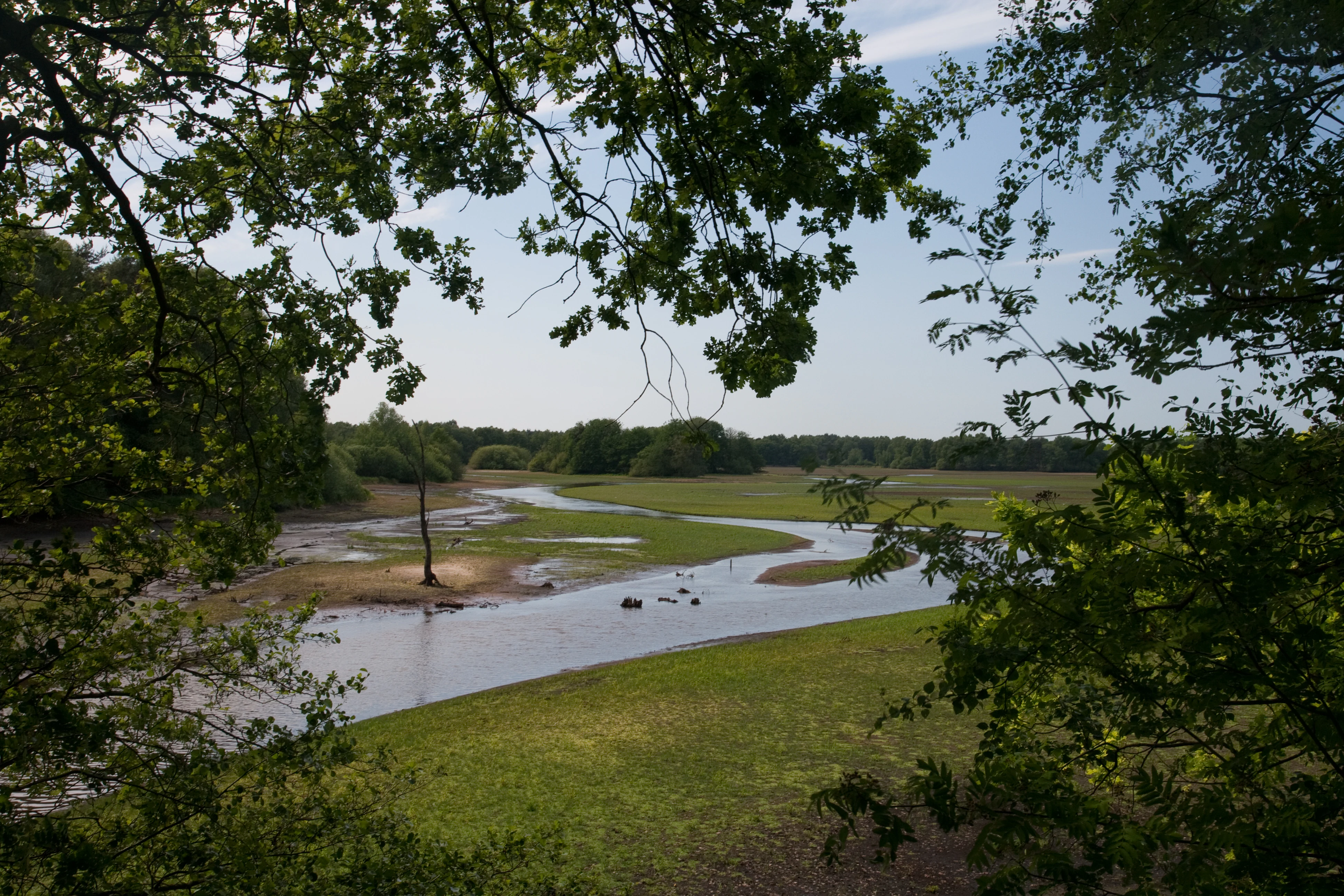
A winding river flows through a grassy wetland area, framed by the dark green leaves of overhanging trees.
The Soeste River winding through the Thülsfeld Reservoir nature reserve.

Talsperre Thülsfeld history and protected-area timeline

The natural values of the Thülsfeld area have been officially recognized for several decades. An initial nature reserve was established at the site on 5 February 1938, reflecting an early understanding that the heath, bog, and inland dune landscape along the Soeste valley was worth protecting. That early designation was later replaced by the current reserve, which has been in force under the designation NSG WE 060 since 9 March 1957.

The creation of the Thülsfelder Stausee itself, by damming the Soeste, added an important aquatic and shoreline dimension to what was already a varied lowland landscape. Over the following decades the site gained additional conservation weight when it was incorporated into the European network of protected areas through the Habitats Directive, formally recognized as the site "Heiden und Moore an der Talsperre Thülsfeld." Open heath in the reserve has been actively maintained by the Zweckverband Thülsfelder Talsperre using large flocks of sheep and goats, an approach that combines traditional land use with modern conservation goals.

In more recent years, public use of the site has been formalized alongside conservation: in October 2017 the reserve opened a roughly ten kilometer interpretive experience trail with fourteen themed stations, designed to walk visitors through the principal habitats and explain their ecological significance. The site therefore represents both a long-running conservation effort and an evolving balance between nature protection, traditional land management, and public access.

Talsperre Thülsfeld landscape and geographic character

The landscape of Talsperre Thülsfeld is a classic example of the gently rolling northwestern German geest. Beneath the surface the land is shaped by glacial ground moraines, while on top it carries the unmistakable imprint of inland dune formation: low sandy ridges, drier crests, and slightly damper depressions create a subtle but ecologically decisive topography. The Soeste river has carved a shallow valley through this terrain, and the modern reservoir fills part of that valley, linking the riverine and the dry sandy worlds in a single continuous landscape.

The reservoir itself is long and narrow, stretching around five kilometers and holding roughly 165 hectares of open water at normal levels. Its shoreline is highly indented, forming numerous bays, shallow flats, and small islands. Surrounding the water, the relief transitions gradually into heath on the drier western side and into wetter woodland and boggy Soeste floodplain upstream. This combination of open water, sandy heath, and wooded river floodplain is what gives the site its distinctive visual variety: wide horizons across the reservoir, dry open heath to the west, dark woodland to the south, and a quietly meandering river disappearing into wet woodland upstream.
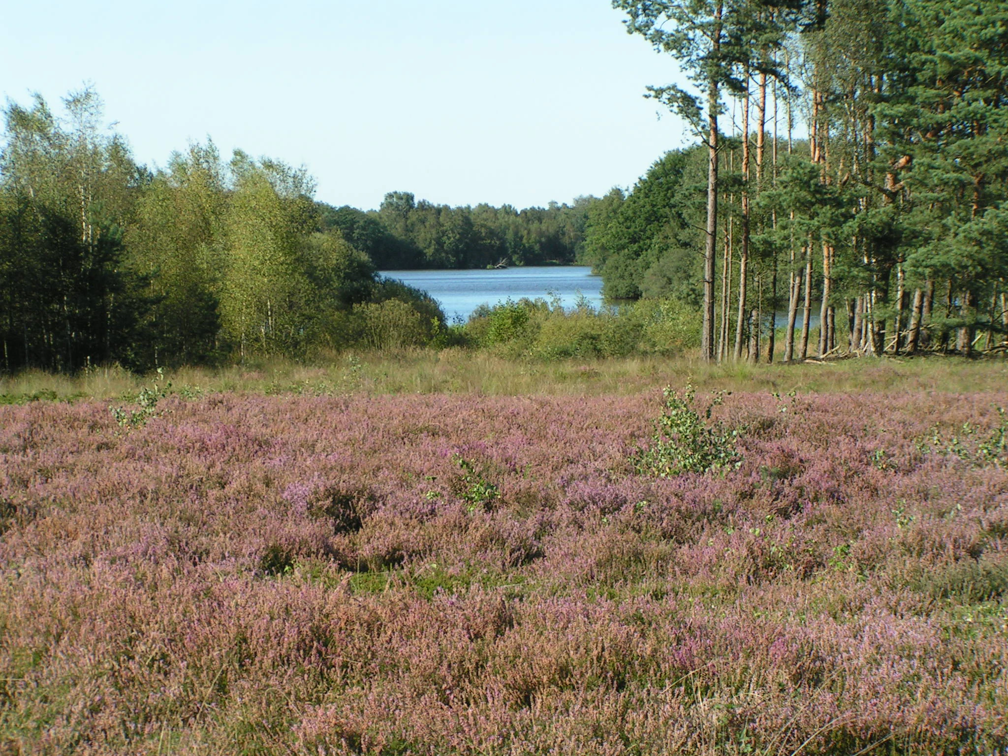
A wide view of a purple heathland in full bloom in the foreground, transitioning to a dense forest and a reservoir in the background under a clear sky.
Heathlands in bloom on the banks of the Thülsfeld Reservoir.

Talsperre Thülsfeld ecosystems, habitats, and plant life

The ecological identity of the reserve rests on the close interplay of five major habitat complexes: open water and shoreline, river and bog, heath, dry sandy grassland, and forest. Each of these contributes different species and structures, and the transitions between them, for instance between damp heath and birch swamp along the Soeste, or between dry heath and pine forest on the dunes, are often where the richest biodiversity occurs.

The reservoir is floored in many places by pondweed and frogbit communities in its shallow bays, while the margins host reeds, sedge beds, and willow scrub, grading into swamp forest dominated by alder and birch. The Soeste upstream runs in a near-natural bed through a partly boggy floodplain, lined with woodland and supporting submerged aquatic vegetation. To the west lie extensive heath areas, with broom heather dominant on dry ground, cross-leaved heath on wetter patches, and crowberry locally abundant. Gorse species, bell heather, silver grass, and various bunch grasses colonize the sand flats and transitions.

Forest cover is substantial on the western and southern sides. Pine forests occupy the poorer sandy soils, while oak woods rich in pedunculate and sessile oak, along with birch, rowan, aspen, and remnant beech, form a more diverse broadleaf matrix. Some of these woods reflect older management systems: wood-pasture with old open-grown trees and traditional coppice woodland. Beech stands are present as Hainsimsen-beech forest on slightly more base-rich patches. Small floating Sphagnum mats, sweet gale scrub, and tiny raised bog remnants add unusual mire elements that complement the larger heath and bog pattern.

Talsperre Thülsfeld wildlife and species highlights

The defining wildlife feature of Talsperre Thülsfeld is its waterbird fauna. The Thülsfelder Stausee is habitat for a diverse community of water-associated birds, and the reserve gains particular ecological significance during the spring and autumn migration periods, when the reservoir and its bays serve as a major resting and feeding area for numerous migratory waterfowl. The combination of open water, shallow bays, reed-fringed inlets, and adjacent damp meadows and bogs produces a wide range of foraging and roosting conditions within a small radius.

Beyond the reservoir itself, the mosaic of boggy Soeste floodplain, swamp forest, dry heath, and inland dune supports the expected range of northwestern German lowland fauna: wetland and bog species along the river corridor, heath and sand specialists on the drier ground, and woodland-associated species in the oak, birch, and pine forests. The presence of historical wood-pasture trees and coppice woodland further increases structural diversity in the forested zones, providing nesting and feeding opportunities for bird and insect species associated with older, more open woodlands.

Talsperre Thülsfeld conservation status and protection priorities

Talsperre Thülsfeld is protected at both national and European levels. Nationally it has been a designated nature reserve (Naturschutzgebiet) since 9 March 1957, replacing an earlier 1938 designation, and carries the reference NSG WE 060. It is administered by the district of Cloppenburg as the responsible lower nature protection authority. At European level, most of the reserve coincides with the roughly 434 hectare Habitats Directive site "Heiden und Moore an der Talsperre Thülsfeld," placing it within the Natura 2000 network and giving it formal recognition for its heath, bog, and forest habitat types.

The overarching conservation purpose of the area is to safeguard the complex of heath biotopes, mires, partly wooded inland dunes, and the aquatic and riverside habitats of the Thülsfelder Stausee, the Soeste, and its tributaries. Active management is central to this mission: roughly 220 sheep and around 70 goats are deployed year-round by the Zweckverband Thülsfelder Talsperre to prevent the valuable heath from becoming overgrown with shrubs and trees. The surrounding landscape protection areas along the Soeste valley and the Dwergter Sand extend the protected landscape context beyond the strict reserve boundary, while an interpretive trail opened in 2017 extends the conservation mission into public education and awareness.

Top sights and standout views in Talsperre Thülsfeld

The defining highlights of Talsperre Thülsfeld include roughly 68 hectares of heathland ranking among the largest in Lower Saxony, a long, island-studded reservoir with extensive shallow bays and marsh-fringed margins, a near-natural stretch of the Soeste river with boggy floodplain, and an unusually intact inland dune system with associated dry and wet heath transitions. A ten kilometer interpretive trail opened in October 2017 ties these features together for visitors and reflects the site's dual role as a serious conservation area and a public recreational landscape.

Best time to visit Talsperre Thülsfeld

Spring and early summer are particularly rewarding for visitors, when heath species come into bloom and the reservoir and Soeste valley host the most active bird communities, including returning breeders. Autumn brings the second peak for nature interest, as migratory waterfowl use the reservoir as a staging area while heath and woodland take on warmer colours. Winter can be quieter and colder, but the open water and bare deciduous trees often make waterbirds and landscape views easier to observe. The interpretive trail and walking paths are best enjoyed in mild, dry weather, when both heath and reservoir scenery are at their most accessible.

Monthly climate preview

Long-term representative temperature ranges and precipitation rhythm for Talsperre Thülsfeld

Talsperre Thülsfeld Climate Normals and Monthly Weather Patterns

Representative coordinate measurements reveal annual temperature and precipitation cycles across twelve recorded intervals for Talsperre Thülsfeld. Examining the complete monthly climate profile provides deeper context on long-term thermal averages and daily extremes.
Annual mean9 °C
1 °C18 °C
Jan
Feb
Mar
Apr
May13°
Jun16°
Jul18°
Aug18°
Sep14°
Oct10°
Nov
Dec
Warmest month
July

17.9 °C

Coolest month
January

1.2 °C

Wettest month
July

2.5 mm/day

Driest month
April

1.4 mm/day

Park location guide

Geography guide, regional context, and park location map for Talsperre Thülsfeld

Talsperre Thülsfeld park geography, regions, and map view in Germany

Understand where Talsperre Thülsfeld sits in Germany through a broader geographic reading of the surrounding landscape, nearby location context, and its mapped position within the national park landscape.

How Talsperre Thülsfeld fits into Germany

Germany is a federal republic in Western and Central Europe with a population of over 83 million across sixteen constituent states. It is Europe's largest economy by nominal GDP and a major global exporter and importer. The capital is Berlin, and the country borders Denmark, Poland, Czech Republic, Austria, Switzerland, France, Luxembourg, Belgium, and the Netherlands.

Wider geography shaping Talsperre Thülsfeld in Germany

Germany is located in Western and Central Europe, spanning 357,022 km². It borders Denmark to the north, Poland and the Czech Republic to the east, Austria and Switzerland to the south, and France, Luxembourg, Belgium, and the Netherlands to the west. The country has coastlines on the Baltic Sea and North Sea to the north, with the Alps located in the southern region.

Map view of Talsperre Thülsfeld

Use this park location map to pinpoint Talsperre Thülsfeld in Germany, understand its exact geographic position, and read its mapped placement within the surrounding landscape more clearly.

Pigeon | © OpenStreetMap contributors

Location context for Talsperre Thülsfeld

Landkreis CloppenburgNiedersachsen

Explore protected habitats, glacial geest terrain, and lowland ecosystems in visual detail.

Talsperre Thülsfeld Photos and Landscape Scenery: Visualizing the Reserve

Visual documentation captures the varied terrain of Talsperre Thülsfeld, revealing open reservoir waters, extensive heathland, and meandering river floodplains. Examining these protected habitats provides a clearer understanding of northwestern German lowland conservation geography.

A winding river flows through a grassy wetland area, framed by the dark green leaves of overhanging trees.

A wide panoramic photograph showing the Thülsfeld Reservoir with calm water, framed by trees on the left and dense green shore vegetation on the right.

A wide view of a purple heathland in full bloom in the foreground, transitioning to a dense forest and a reservoir in the background under a clear sky.

Park atlas

Compare nearby regional nature reserves, lowland habitats, and protected river valleys.

Exploring Other Parks Near Talsperre Thülsfeld and Surrounding Protected Landscapes

Continue browsing other parks near Talsperre Thülsfeld to compare similar glacial geest terrains, heathlands, and wetland reserves across the surrounding region. Examining adjacent protected areas provides deeper context into northwestern German lowland conservation and river valley ecosystems.
Protected landscapeEmsland
About 24 km away#1 closest

West

Naturpark Hümmling: Geographic Overview of Emsland Protected Landscapes

Tracing glacial sand ridges, moorlands, and prehistoric cultural sites.

Naturpark Hümmling stands as a prominent protected landscape in Lower Saxony, characterized by its distinctive geest ridge, extensive raised bogs, and dense concentration of Neolithic stone monuments. The area map highlights a complex interplay of river valleys, heathland remnants, and historic cultural landmarks that define the geographical identity of this Emsland treasure.

Area
576 km²
Established
2015
Relief
Upland
Climate
Temperate
Nature reserveOldenburg
About 26 km away#2 closest

Northeast

Tannersand und Gierenberg Nature Reserve: Inland Dunes and Bog Pool Mapping

Protected sandy geest landscape within the Osenberge near Oldenburg

Tannersand und Gierenberg represents a vital nature reserve featuring an unusual inland dune system and embedded wetland Slatts. The protected area exhibits a dense contrast between coniferous dune ridges and peat-moss-rich swamps. This record details the park boundaries, landscape mosaic, and the specific terrain that classifies it as a significant protected site within Lower Saxony, Germany.

Area
0.35 km²
Established
1938
Nature reserveLower Saxony
About 28 km away#3 closest

West

Windelberg Nature Reserve: Protected Inland Dune and Heathland Mosaic in Lower Saxony

Historic sandy heath and oak woodland conservation site

Windelberg is a significant nature reserve in the Emsland region, featuring inland dunes and juniper heathland on the Hümmling glacial ridge. This area showcases a compact mosaic of dry, acidic habitats and relict oak woodland that reflects centuries of traditional land management in northwest Germany. Its status as a protected area within the Natura 2000 network highlights its importance for regional habitat conservation.

Area
0.163 km²
Established
2009
IUCN
IV
Nature reserveLandkreis Osnabrück
About 32 km away#4 closest

Southwest

Suddenmoor Nature Reserve: Mapped Protected Landscapes in Landkreis Osnabrück

Lowland peatland habitats and regional German geography

Suddenmoor serves as a crucial nature reserve in Landkreis Osnabrück, characterized by its flat, peat-rich soil and dense network of drainage channels. The reserve preserves an authentic Artland landscape, featuring a rare combination of wet meadow ecosystems and traditional Wallhecken field boundaries. This protected area stands as a vital connector between larger wetland complexes in the northern German lowland terrain.

Area
3.11 km²
Established
2018
Relief
Lowland
Climate
Temperate
Nature reserveEmsland
About 32 km away#5 closest

Southwest

Zitterteiche Nature Reserve in Emsland: Mapped Protected Landscapes and Geography

A study of lowland heath ponds and environmental history

Zitterteiche represents a specific, small-scale nature reserve in the Emsland of Germany, consisting of two shallow heath ponds defined by their surrounding agricultural plains. This detailed entry maps the physical terrain and ecological shift of these protected waters, offering a focused perspective on the regional geography and the historical trajectory of this unique, formally protected wetland area.

Area
0.029 km²
Established
1937
IUCN
IV
Relief
Lowland
Watercolor painting of a green and pink landscape featuring a forest line with tall grasses in the foreground and soft hills in the background.
Protected landscapeNiedersachsen
About 33 km away#6 closest

North

Elmendorfer Holz: Protected Landscape and Forest Ecology in Niedersachsen, Germany

Mapping lowland forest habitats and regional protected boundaries

Elmendorfer Holz is a significant protected area and forest reserve situated north of the Zwischenahner Meer. It is defined by its near-natural oak and hornbeam canopy and dense layering of conservation status. The forest serves as a vital ecological anchor within the broader agricultural mosaic of the Ammerland district, providing a clear reference for northwestern German lowland woodland characteristics.

Area
0.285 km²
Established
2007
Nature reserveAmmerland
About 35 km away#7 closest

Northwest

Vreschen-Bokel am Aper Tief: Protected Nature Reserve and River Wetland Geography

Mapping the lowland meadows and tidal channels of Ammerland, Germany.

Vreschen-Bokel am Aper Tief protects a complex landscape of species-rich meadows and ancient river channels of the Aper Tief. Situated in the flat terrain of the Ammerland district, this reserve provides a vital glimpse into the hydrological character of the northwestern German coastal region and its ongoing ecological restoration.

Area
1.044 km²
Established
2009
IUCN
IV
Relief
Lowland
Nature reserveOldenburg
About 36 km away#8 closest

East

Stühe Nature Reserve: A Detailed Map and Geographic Overview of the Delmenhorster Geest

Protected beech forests and lowland bog ecosystems in Oldenburg

Stühe serves as a significant forest refuge in the Oldenburg district, showcasing a rare intersection of beech, oak, and riparian floodplain forests. This nature reserve, anchored within the wider Delmenhorster Geest landscape, features glacial depressions, kettle-like stillwaters, and preserved bog monuments that document the natural history of the northwest German lowlands.

Area
2.17 km²
Established
2018
Relief
Lowland
Climate
Temperate

Common questions about visiting, size, designation, and location context for Talsperre Thülsfeld

Talsperre Thülsfeld FAQs for park facts, access, geography, and protected area context

Find quick answers about Talsperre Thülsfeld, including protected-area facts, park geography, trail and visitor context, and how the park fits into its surrounding country and regional landscape.
MoriAtlas Explorer

Continue Your Protected Areas Search Across the Global Atlas

Deepen your exploration by continuing the structured search for national parks and protected areas worldwide. Utilize the comprehensive filtering capabilities to compare different conservation landscapes and refine your understanding of global park geography. Discover more about the distribution and characteristics of protected natural areas.

Global natural geography